Bridge Statistics for Lapwai, Idaho (ID)
Condition, Traffic, Stress, Structural Evaluation, Project Costs
- National Bridge Inventory (NBI) Statistics
- 11Number of bridges
- 305ft / 92.8mTotal length
- $27,729,000Total costs
- 34,245Total average daily traffic
- 5,412Total average daily truck traffic
- National Bridge Inventory (NBI) Registered Bridges for Lapwai
- No street view available for this location
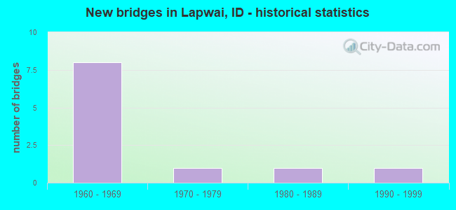
- New bridges - historical statistics
- 81960-1969
- 11970-1979
- 11980-1989
- 11990-1999
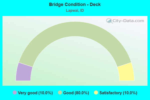
- Bridge Condition - Deck
- 10.0%Very good
- 80.0%Good
- 10.0%Satisfactory
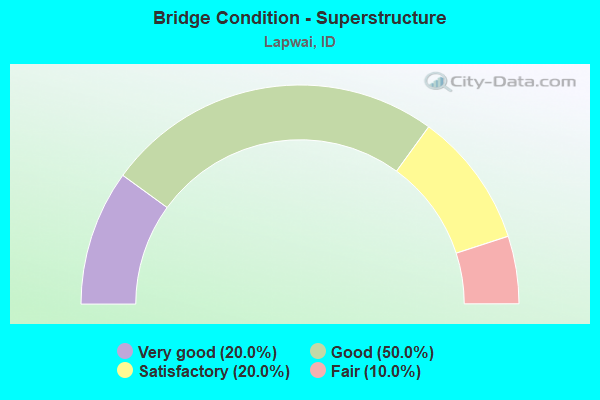
- Bridge Condition - Superstructure
- 20.0%Very good
- 50.0%Good
- 20.0%Satisfactory
- 10.0%Fair

- Bridge Condition - Substructure
- 40.0%Good
- 40.0%Satisfactory
- 20.0%Fair
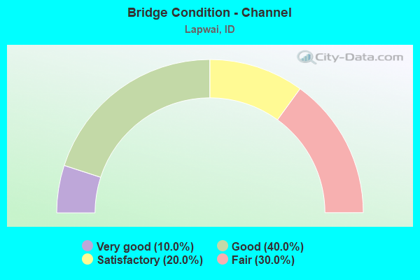
- Bridge Condition - Channel
- 10.0%Very good
- 40.0%Good
- 20.0%Satisfactory
- 30.0%Fair
Find on map >> Show street view
Structure Number: 1004, Location: 8 S. JULIAETTA (Lat: 46.472639, Lng: -116.772222), Route carried "on" structure: State highway 3, Year Built: 1968, Status: Open, Structure Length: 1.98m (6.50ft), Average Daily Traffic: 2,500 (year 2019), Truck Traffic: 24%, Average Future Daily Traffic: 3,750 (year 2039), Design Load: HS 20, Features Intersected: ARROW GULCH
Minimum Vertical Clearance: 30+ m (98+ ft), Kilometerpoint: 0.151, Lanes on structure: 2, Base Highway Network: Yes (Inventory Route: SH0, Subroute: 1), Owner: State Highway Agency, Approaching Roadway Width: 10.4m (34.1ft), Material/Design: Prestressed concrete, Design/Construction: Stringer/Multi-beam, Number Of Spans In Main Unit: 1, Length of Maximum Span: 19.5m (64.0ft), Curb-To-Curb Width: 10.4m (34.1ft), Out-to-Out Width: 11.2m (36.7ft)
Condition: Deck: Good, Superstructure: Good, Substructure: Satisfactory, Channel: Very good, Operating Rating: 53.5 metric tons, Method Used To Determine Operating Rating: Load Factor (LF), Inventory Rating: 31.8 metric tons, Method Used To Determine Inventory Rating: Load Factor (LF), Structural Evaluation: Equal to present minimum criteria, Deck Geometry: Somewhat better than minimum adequacy, Waterway Adequacy: Superior to present desirable criteria, Approach Roadway Alignment: Equal to present desirable criteria, Designated Inspection Frequency: Every 24 months, Inspection Date: Febuary 2021, Deck Structure Type: Concrete Cast-file-Place, Wearing Surface/Protective System: Wearing Surface: Latex Concrete
Find on map >> Show street view
Structure Number: 10385, Location: 9.3 E. LEWISTON (Lat: 46.460361, Lng: -116.787806), Route carried "on" structure: US 12, Year Built: 1968, Status: Open, Structure Length: 4.02m (13.19ft), Average Daily Traffic: 7,000 (year 2019), Truck Traffic: 9%, Average Future Daily Traffic: 10,500 (year 2039), Design Load: HS 20, Features Intersected: APRROACH RD;CATHOLIC CR.
Minimum Vertical Clearance: 30+ m (98+ ft), Kilometerpoint: 22.365, Lanes on structure: 2, Base Highway Network: Yes (Inventory Route: US0, Subroute: 5), Owner: State Highway Agency, Approaching Roadway Width: 12.2m (40.0ft), Skew: 2 degrees, Material/Design: Prestressed concrete, Design/Construction: Stringer/Multi-beam, Number Of Spans In Main Unit: 3, Length of Maximum Span: 14.9m (48.9ft), Curb-To-Curb Width: 12.2m (40.0ft), Out-to-Out Width: 13.1m (43.0ft)
Condition: Deck: Good, Superstructure: Very good, Substructure: Good, Channel: Good, Operating Rating: 49.0 metric tons, Method Used To Determine Operating Rating: Load Factor (LF), Inventory Rating: 29.0 metric tons, Method Used To Determine Inventory Rating: Load Factor (LF), Structural Evaluation: Better than present minimum criteria, Deck Geometry: Somewhat better than minimum adequacy, Waterway Adequacy: Equal to present desirable criteria, Approach Roadway Alignment: Equal to present desirable criteria, Designated Inspection Frequency: Every 48 months, Inspection Date: Febuary 2019, Deck Structure Type: Concrete Cast-file-Place, Wearing Surface/Protective System: Wearing Surface: Latex Concrete
Find on map >> Show street view
Structure Number: 1039, Location: 10.4 E. LEWISTON (Lat: 46.471556, Lng: -116.773361), Route carried "on" structure: US 12, Year Built: 1972, Status: Open, Structure Length: 38.04m (124.80ft), Average Daily Traffic: 4,000 (year 2019), Truck Traffic: 15%, Average Future Daily Traffic: 6,000 (year 2039), Design Load: HS 20, Features Intersected: CLWATER R.;NPRR;ARROW BR
Minimum Vertical Clearance: 30+ m (98+ ft), Kilometerpoint: 24.076, Lanes on structure: 2, Base Highway Network: Yes (Inventory Route: US0, Subroute: 5), Owner: State Highway Agency, Approaching Roadway Width: 12.2m (40.0ft), Skew: 3 degrees, Navigation Control: Yes ( Vertical Clearance: 2.0m (6.6ft), Horizontal Clearance: 36.0m (118.1ft)), Material/Design: Steel continuous, Design/Construction: Stringer/Multi-beam, Number Of Spans In Main Unit: 8, Length of Maximum Span: 76.2m (250.0ft), Curb-To-Curb Width: 12.4m (40.7ft), Out-to-Out Width: 13.4m (44.0ft)
Condition: Deck: Good, Superstructure: Satisfactory, Substructure: Fair, Channel: Good, Operating Rating: 37.2 metric tons, Method Used To Determine Operating Rating: Load Factor (LF), Inventory Rating: 21.8 metric tons, Method Used To Determine Inventory Rating: Load Factor (LF), Structural Evaluation: Somewhat better than minimum adequacy, Deck Geometry: Equal to present minimum criteria, Underclear: Somewhat better than minimum adequacy, Waterway Adequacy: Superior to present desirable criteria, Approach Roadway Alignment: Equal to present desirable criteria, Length Of Structure Improvement: 38.10m (125.00ft), Designated Inspection Frequency: Every 24 months, Underwater Inspection Frequency: Every 60 months, Other Special Inspection Frequency: Every 48 months, Inspection Date: October 2021, Underwater Inspection Date: September 2017, Other Special Inspection Date: October 2019, Bridge Improvement Cost: $9,900,000, Roadway Improvement Cost: $990,000, Total Project Cost: $14,900,000 ( Estimate for 2017), Deck Structure Type: Concrete Cast-file-Place, Wearing Surface/Protective System: Wearing Surface: Epoxy Overlay
Find on map >> Show street view
Structure Number: 18455, Location: 1 N. LAPWAI (Lat: 46.423556, Lng: -116.803972), Route carried "on" structure: US 95, Year Built: 1964, Status: Open, Structure Length: 2.26m (7.41ft), Average Daily Traffic: 5,300 (year 2019), Truck Traffic: 15%, Average Future Daily Traffic: 7,950 (year 2039), Design Load: HS 20, Features Intersected: LAPWAI CREEK
Minimum Vertical Clearance: 30+ m (98+ ft), Kilometerpoint: 484.456, Lanes on structure: 2, Base Highway Network: Yes (Inventory Route: US0, Subroute: 1), Owner: State Highway Agency, Approaching Roadway Width: 12.2m (40.0ft), Skew: 4 degrees, Material/Design: Prestressed concrete, Design/Construction: Stringer/Multi-beam, Number Of Spans In Main Unit: 1, Length of Maximum Span: 21.0m (68.9ft), Curb-To-Curb Width: 12.2m (40.0ft), Out-to-Out Width: 12.8m (42.0ft)
Condition: Deck: Good, Superstructure: Very good, Substructure: Satisfactory, Channel: Good, Operating Rating: 66.2 metric tons, Method Used To Determine Operating Rating: Load Factor (LF), Inventory Rating: 39.9 metric tons, Method Used To Determine Inventory Rating: Load Factor (LF), Structural Evaluation: Equal to present minimum criteria, Deck Geometry: Somewhat better than minimum adequacy, Waterway Adequacy: Superior to present desirable criteria, Approach Roadway Alignment: Equal to present desirable criteria, Designated Inspection Frequency: Every 24 months, Inspection Date: November 2021, Deck Structure Type: Concrete Cast-file-Place, Wearing Surface/Protective System: Wearing Surface: Epoxy Overlay
Find on map >> Show street view
Structure Number: 1846, Location: SPAULDING CITY LIMITS (Lat: 46.443389, Lng: -116.812417), Route carried "on" structure: US 95, Year Built: 1964, Status: Open, Structure Length: 2.26m (7.41ft), Average Daily Traffic: 5,300 (year 2019), Truck Traffic: 15%, Average Future Daily Traffic: 7,950 (year 2039), Design Load: HS 20, Features Intersected: LAPWAI CREEK
Minimum Vertical Clearance: 30+ m (98+ ft), Kilometerpoint: 486.764, Lanes on structure: 2, Base Highway Network: Yes (Inventory Route: US0, Subroute: 1), Owner: State Highway Agency, Approaching Roadway Width: 12.2m (40.0ft), Skew: 4 degrees, Material/Design: Prestressed concrete, Design/Construction: Stringer/Multi-beam, Number Of Spans In Main Unit: 1, Length of Maximum Span: 21.0m (68.9ft), Curb-To-Curb Width: 12.2m (40.0ft), Out-to-Out Width: 12.8m (42.0ft)
Condition: Deck: Good, Superstructure: Satisfactory, Substructure: Satisfactory, Channel: Fair, Operating Rating: 66.2 metric tons, Method Used To Determine Operating Rating: Load Factor (LF), Inventory Rating: 39.9 metric tons, Method Used To Determine Inventory Rating: Load Factor (LF), Structural Evaluation: Equal to present minimum criteria, Deck Geometry: Somewhat better than minimum adequacy, Waterway Adequacy: Superior to present desirable criteria, Approach Roadway Alignment: Equal to present desirable criteria, Designated Inspection Frequency: Every 24 months, Inspection Date: November 2021, Deck Structure Type: Concrete Cast-file-Place, Wearing Surface/Protective System: Wearing Surface: Epoxy Overlay
Find on map >> Show street view
Structure Number: 18465, Location: 4 N. LAPWAI (Lat: 46.442508, Lng: -116.842700), Route carried "on" structure: US 95, Year Built: 1962, Status: Open, Structure Length: 37.49m (123.00ft), Average Daily Traffic: 6,000 (year 2019), Truck Traffic: 27%, Average Future Daily Traffic: 9,000 (year 2039), Design Load: HS 20, Features Intersected: NPRR;CLEARWATER RIVER
Minimum Vertical Clearance: 30+ m (98+ ft), Kilometerpoint: 489.430, Lanes on structure: 2, Base Highway Network: Yes (Inventory Route: US0, Subroute: 1), Owner: State Highway Agency, Approaching Roadway Width: 8.5m (27.9ft), Navigation Control: Yes ( Vertical Clearance: 8.0m (26.2ft), Horizontal Clearance: 35.0m (114.8ft)), Material/Design: Steel, Design/Construction: Stringer/Multi-beam, Number Of Spans In Main Unit: 11, Length of Maximum Span: 36.6m (120.1ft), Curb-To-Curb Width: 8.5m (27.9ft), Out-to-Out Width: 10.1m (33.1ft)
Condition: Deck: Satisfactory, Superstructure: Fair, Substructure: Satisfactory, Channel: Satisfactory, Operating Rating: 68.0 metric tons, Method Used To Determine Operating Rating: Load Factor (LF), Inventory Rating: 40.8 metric tons, Method Used To Determine Inventory Rating: Load Factor (LF), Structural Evaluation: Somewhat better than minimum adequacy, Deck Geometry: Meets minimum limits, Underclear: Meets minimum limits, Waterway Adequacy: Superior to present desirable criteria, Approach Roadway Alignment: Equal to present desirable criteria, Length Of Structure Improvement: 37.46m (122.90ft), Designated Inspection Frequency: Every 24 months, Underwater Inspection Frequency: Every 60 months, Other Special Inspection Frequency: Every 24 months, Inspection Date: October 2021, Underwater Inspection Date: October 2020, Other Special Inspection Date: October 2021, Bridge Improvement Cost: $8,111,000, Roadway Improvement Cost: $811,000, Total Project Cost: $12,167,000 ( Estimate for 2019), Deck Structure Type: Concrete Cast-file-Place, Wearing Surface/Protective System: Wearing Surface: Epoxy Overlay
Find on map >> Show street view
Structure Number: 29831, Location: 0.7 S. 0.1 E. LAPWAI (Lat: 46.393917, Lng: -116.798389), Route carried "on" structure: County highway , Year Built: 1995, Status: Open, Structure Length: 1.80m (5.91ft), Average Daily Traffic: 230 (year 2019), Truck Traffic: 15%, Average Future Daily Traffic: 345 (year 2039), Design Load: HS 25 or greater, Features Intersected: LAPWAI CR;GARDEN GULCH, Facility Carried by Structure: GARDEN GULCH ROAD
Minimum Vertical Clearance: 30+ m (98+ ft), Kilometerpoint: 160.974, Lanes on structure: 2, Owner: County Highway Agency, Approaching Roadway Width: 6.4m (21.0ft), Material/Design: Prestressed concrete, Design/Construction: Tee Beam, Number Of Spans In Main Unit: 1, Length of Maximum Span: 17.4m (57.1ft), Curb-To-Curb Width: 7.4m (24.3ft), Out-to-Out Width: 7.5m (24.6ft)
Condition: Deck: Good, Superstructure: Good, Substructure: Good, Channel: Good, Operating Rating: 47.2 metric tons, Method Used To Determine Operating Rating: Load Factor (LF), Inventory Rating: 17.2 metric tons, Method Used To Determine Inventory Rating: Load Factor (LF), Structural Evaluation: Somewhat better than minimum adequacy, Deck Geometry: Somewhat better than minimum adequacy, Waterway Adequacy: Better than present minimum criteria, Approach Roadway Alignment: Equal to present desirable criteria, Length Of Structure Improvement: 2.53m (8.30ft), Designated Inspection Frequency: Every 24 months, Inspection Date: September 2020, Bridge Improvement Cost: $411,000, Roadway Improvement Cost: $41,000, Total Project Cost: $617,000 ( Estimate for 2016), Deck Structure Type: Concrete Precast Panels, Wearing Surface/Protective System: Wearing Surface: Bituminous
Find on map >> Show street view
Structure Number: 2986, Location: 1.0 N. 0.1 E. LAPWAI (Lat: 46.416750, Lng: -116.800028), Route carried "on" structure: County highway , Year Built: 1963, Status: Open, Structure Length: 1.46m (4.79ft), Average Daily Traffic: 80 (year 2019), Truck Traffic: 13%, Average Future Daily Traffic: 120 (year 2039), Design Load: HS 20, Features Intersected: LAPWAI CREEK, Facility Carried by Structure: TOM BEALL ROAD
Minimum Vertical Clearance: 30+ m (98+ ft), Kilometerpoint: 161.148, Lanes on structure: 2, Owner: County Highway Agency, Approaching Roadway Width: 7.3m (24.0ft), Material/Design: Concrete, Design/Construction: Tee Beam, Number Of Spans In Main Unit: 1, Length of Maximum Span: 14.0m (45.9ft), Curb or Sidewalk Widths: Left: 0.2m (0.7ft), Right: 0.2m (0.7ft), Curb-To-Curb Width: 7.3m (24.0ft), Out-to-Out Width: 7.9m (25.9ft)
Condition: Deck: Good, Superstructure: Good, Substructure: Good, Channel: Fair, Operating Rating: 71.7 metric tons, Method Used To Determine Operating Rating: Load Factor (LF), Inventory Rating: 42.6 metric tons, Method Used To Determine Inventory Rating: Load Factor (LF), Structural Evaluation: Better than present minimum criteria, Deck Geometry: Equal to present minimum criteria, Waterway Adequacy: Better than present minimum criteria, Approach Roadway Alignment: Equal to present desirable criteria, Designated Inspection Frequency: Every 24 months, Inspection Date: July 2020, Deck Structure Type: Concrete Cast-file-Place, Wearing Surface/Protective System: Wearing Surface: Monolithic Concrete
Find on map >> Show street view
Structure Number: 29875, Location: 1.5 N. 0.2 W. LAPWAI (Lat: 46.426694, Lng: -116.805833), Route carried "on" structure: County highway , Year Built: 1963, Status: Open, Structure Length: 1.46m (4.79ft), Average Daily Traffic: 110 (year 2019), Truck Traffic: 10%, Average Future Daily Traffic: 165 (year 2039), Design Load: HS 20, Features Intersected: LAPWAI CREEK, Facility Carried by Structure: RED DUCK LANE
Minimum Vertical Clearance: 30+ m (98+ ft), Kilometerpoint: 161.043, Lanes on structure: 2, Owner: County Highway Agency, Approaching Roadway Width: 7.3m (24.0ft), Material/Design: Concrete, Design/Construction: Tee Beam, Number Of Spans In Main Unit: 1, Length of Maximum Span: 14.0m (45.9ft), Curb or Sidewalk Widths: Left: 0.2m (0.7ft), Right: 0.2m (0.7ft), Curb-To-Curb Width: 7.3m (24.0ft), Out-to-Out Width: 7.9m (25.9ft)
Condition: Deck: Good, Superstructure: Good, Substructure: Fair, Channel: Fair, Operating Rating: 71.7 metric tons, Method Used To Determine Operating Rating: Load Factor (LF), Inventory Rating: 42.6 metric tons, Method Used To Determine Inventory Rating: Load Factor (LF), Structural Evaluation: Somewhat better than minimum adequacy, Deck Geometry: Somewhat better than minimum adequacy, Waterway Adequacy: Better than present minimum criteria, Approach Roadway Alignment: Equal to present minimum criteria, Designated Inspection Frequency: Every 24 months, Inspection Date: July 2020, Deck Structure Type: Concrete Cast-file-Place, Wearing Surface/Protective System: Wearing Surface: Monolithic Concrete
Find on map >> Show street view
Structure Number: 9370001P, Location: 1.4 miles southeast of Jc (Lat: 46.448500, Lng: -116.817917), Route carried "on" structure: Federal lands road 10, Year Built: 1988, Status: Posted for load, Structure Length: 1.98m (6.50ft), Average Daily Traffic: 225 (year 2008), Truck Traffic: 1%, Average Future Daily Traffic: 300 (year 2028), Design Load: HS 15, Features Intersected: LAPWAI CREEK, Facility Carried by Structure: ENTRANCE ROAD
Minimum Vertical Clearance: 30+ m (98+ ft), Kilometerpoint: 0.386, Lanes on structure: 2, Owner: National Park Service, Approaching Roadway Width: 9.8m (32.2ft), Material/Design: Wood or Timber, Design/Construction: Truss - Thru, Number Of Spans In Main Unit: 1, Length of Maximum Span: 18.3m (60.0ft), Curb or Sidewalk Widths: Left: 0.0m, Right: 1.2m (3.9ft), Curb-To-Curb Width: 5.5m (18.0ft), Out-to-Out Width: 7.3m (24.0ft)
Condition: Deck: Very good, Superstructure: Good, Substructure: Good, Channel: Satisfactory, Operating Rating: 35.4 metric tons, Method Used To Determine Operating Rating: Allowable Stress (AS), Inventory Rating: 24.5 metric tons, Method Used To Determine Inventory Rating: Allowable Stress (AS), Structural Evaluation: Equal to present minimum criteria, Waterway Adequacy: Equal to present minimum criteria, Approach Roadway Alignment: Equal to present minimum criteria, Designated Inspection Frequency: Every 24 months, Inspection Date: July 2020, Bridge Improvement Cost: $30,000, Roadway Improvement Cost: $3,000, Total Project Cost: $45,000 ( Estimate for 2014), Deck Structure Type: Wood or Timber, Wearing Surface/Protective System: Wearing Surface: Wood or Timber
Find on map >> Show street view
Structure Number: 1847, Location: 6.1 E. LEWISTON (Lat: 46.446000, Lng: -116.849528), Route carried "under" structure: US 12, Year Built: 1964, Structure Length: 0. m, Average Daily Traffic: 3,500 (year 2018), Truck Traffic: 9%, Features Intersected: US 12;US 12-95 IC, Facility Carried by Structure: US 95
Minimum Vertical Clearance: 5.03m (16.50ft), Kilometerpoint: 17.136, Lanes on structure: 2, Lanes under structure: 2, Material/Design: Prestressed concrete, Design/Construction: Stringer/Multi-beam, Length of Maximum Span: 25.3m (83.0ft)