Bridge Statistics for Latimer, Iowa (IA)
Condition, Traffic, Stress, Structural Evaluation, Project Costs
- National Bridge Inventory (NBI) Statistics
- 26Number of bridges
- 249ft / 75.8mTotal length
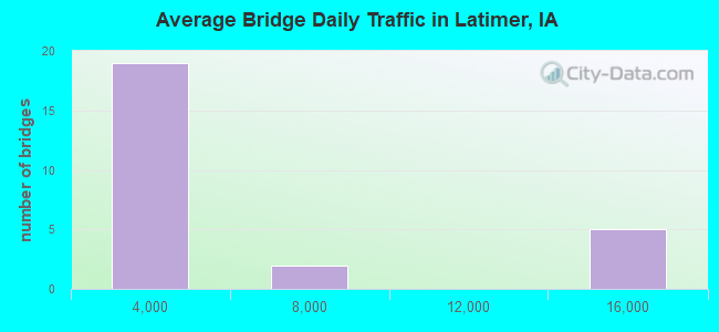
- 86,310Total average daily traffic
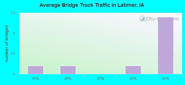
- 26,352Total average daily truck traffic
- National Bridge Inventory (NBI) Registered Bridges for Latimer
- No street view available for this location
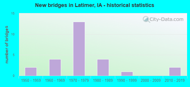
- New bridges - historical statistics
- 21950-1959
- 41960-1969
- 131970-1979
- 41980-1989
- 11990-1999
- 22010-2019
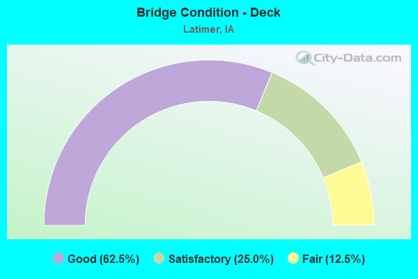
- Bridge Condition - Deck
- 62.5%Good
- 25.0%Satisfactory
- 12.5%Fair
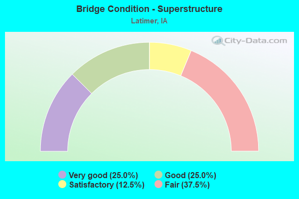
- Bridge Condition - Superstructure
- 25.0%Very good
- 25.0%Good
- 12.5%Satisfactory
- 37.5%Fair
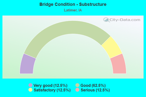
- Bridge Condition - Substructure
- 12.5%Very good
- 62.5%Good
- 12.5%Satisfactory
- 12.5%Serious
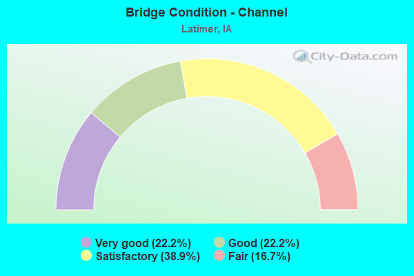
- Bridge Condition - Channel
- 22.2%Very good
- 22.2%Good
- 38.9%Satisfactory
- 16.7%Fair
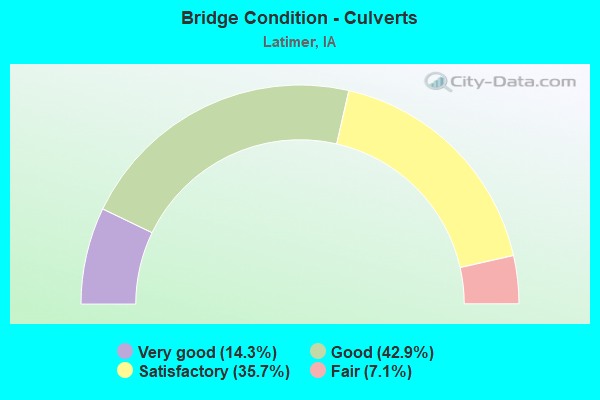
- Bridge Condition - Culverts
- 14.3%Very good
- 42.9%Good
- 35.7%Satisfactory
- 7.1%Fair
Find on map >> Show street view
Structure Number: 157741, Location: 92210402 (Lat: 42.809375, Lng: -93.340464), Route carried "on" structure: County highway , Year Built: 2015, Status: Open, Structure Length: 0.87m (2.85ft), Average Daily Traffic: 50 (year 2013), Average Future Daily Traffic: 50 (year 2040), Design Load: HL 93, Features Intersected: BUFFALO CREEK, Facility Carried by Structure: INDIGO AVE
Minimum Vertical Clearance: 30+ m (98+ ft), Kilometerpoint: 21.494, Lanes on structure: 2, Owner: County Highway Agency, Approaching Roadway Width: 7.9m (25.9ft), Material/Design: Concrete, Design/Construction: Culvert, Number Of Spans In Main Unit: 2, Length of Maximum Span: 3.7m (12.1ft), Curb or Sidewalk Widths: Left: 6.7m (22.0ft), Right: 6.7m (22.0ft)
Condition: Channel: Very good, Culverts: Very good, Operating Rating: 42.1 metric tons, Method Used To Determine Operating Rating: Assigned ratings based on Load and Resistance Factor Design (LRFD) reported by rating factor (RF) using HL93 loadings, Inventory Rating: 32.4 metric tons, Method Used To Determine Inventory Rating: Assigned ratings based on Load and Resistance Factor Design (LRFD) reported by rating factor (RF) using HL93 loadings, Structural Evaluation: Equal to present desirable criteria, Waterway Adequacy: Superior to present desirable criteria, Approach Roadway Alignment: Equal to present desirable criteria, Designated Inspection Frequency: Every 48 months, Inspection Date: June 2020
Find on map >> Show street view
Structure Number: 157751, Location: 092210502 (Lat: 42.810778, Lng: -93.360058), Route carried "on" structure: County highway , Year Built: 1987, Status: Open, Structure Length: 0.64m (2.10ft), Average Daily Traffic: 20 (year 2013), Average Future Daily Traffic: 20 (year 2040), Design Load: HS 20, Features Intersected: BUFFALO CREEK, Facility Carried by Structure: HEATHER AVE
Minimum Vertical Clearance: 30+ m (98+ ft), Kilometerpoint: 22.392, Lanes on structure: 2, Owner: County Highway Agency, Approaching Roadway Width: 7.9m (25.9ft), Material/Design: Concrete continuous, Design/Construction: Culvert, Number Of Spans In Main Unit: 2, Length of Maximum Span: 3.0m (9.8ft)
Condition: Channel: Satisfactory, Culverts: Satisfactory, Operating Rating: 44.1 metric tons, Method Used To Determine Operating Rating: Assigned rating based on Load Factor Design (LFD) reported in metric tons, Inventory Rating: 32.7 metric tons, Method Used To Determine Inventory Rating: Assigned rating based on Load Factor Design (LFD) reported in metric tons, Structural Evaluation: Equal to present minimum criteria, Waterway Adequacy: Better than present minimum criteria, Approach Roadway Alignment: Equal to present desirable criteria, Length Of Structure Improvement: 2.10m (6.89ft), Designated Inspection Frequency: Every 48 months, Inspection Date: June 2020, Bridge Improvement Cost: $15,000, Roadway Improvement Cost: $2,000
Find on map >> Show street view
Structure Number: 15776, Location: 092210601 (Lat: 42.819286, Lng: -93.371922), Route carried "on" structure: County highway , Year Built: 1965, Status: Open, Structure Length: 0.94m (3.08ft), Average Daily Traffic: 20 (year 2013), Average Future Daily Traffic: 20 (year 2040), Design Load: H 20, Features Intersected: BUFFALO CR, Facility Carried by Structure: 200TH STREET
Minimum Vertical Clearance: 30+ m (98+ ft), Kilometerpoint: 10.366, Lanes on structure: 2, Owner: County Highway Agency, Approaching Roadway Width: 7.9m (25.9ft), Material/Design: Steel, Design/Construction: Culvert, Number Of Spans In Main Unit: 2, Length of Maximum Span: 4.0m (13.1ft)
Condition: Channel: Satisfactory, Culverts: Satisfactory, Operating Rating: 42.4 metric tons, Method Used To Determine Operating Rating: Load Factor (LF), Inventory Rating: 39.5 metric tons, Method Used To Determine Inventory Rating: Load Factor (LF), Structural Evaluation: Equal to present minimum criteria, Waterway Adequacy: Better than present minimum criteria, Approach Roadway Alignment: Equal to present desirable criteria, Length Of Structure Improvement: 3.10m (10.17ft), Designated Inspection Frequency: Every 24 months, Inspection Date: June 2020, Bridge Improvement Cost: $15,000, Roadway Improvement Cost: $2,000
Find on map >> Show street view
Structure Number: 157771, Location: 092210901 (Lat: 42.803447, Lng: -93.333928), Route carried "on" structure: County highway , Year Built: 1995, Status: Open, Structure Length: 0.98m (3.22ft), Average Daily Traffic: 900 (year 2021), Truck Traffic: 19%, Average Future Daily Traffic: 900 (year 2039), Design Load: HS 20, Features Intersected: BUFFALO CREEK, Facility Carried by Structure: FM 190TH ST
Minimum Vertical Clearance: 30+ m (98+ ft), Kilometerpoint: 10.194, Lanes on structure: 2, Owner: County Highway Agency, Approaching Roadway Width: 9.8m (32.2ft), Skew: 1 degrees, Material/Design: Concrete, Design/Construction: Culvert, Number Of Spans In Main Unit: 3, Length of Maximum Span: 3.0m (9.8ft)
Condition: Channel: Good, Culverts: Good, Operating Rating: 44.1 metric tons, Method Used To Determine Operating Rating: Assigned rating based on Load Factor Design (LFD) reported in metric tons, Inventory Rating: 32.7 metric tons, Method Used To Determine Inventory Rating: Assigned rating based on Load Factor Design (LFD) reported in metric tons, Structural Evaluation: Better than present minimum criteria, Waterway Adequacy: Better than present minimum criteria, Approach Roadway Alignment: Equal to present desirable criteria, Length Of Structure Improvement: 3.20m (10.50ft), Designated Inspection Frequency: Every 48 months, Inspection Date: June 2019, Bridge Improvement Cost: $15,000, Roadway Improvement Cost: $2,000
Find on map >> Show street view
Structure Number: 157781, Location: 092211002 (Lat: 42.800586, Lng: -93.320900), Route carried "on" structure: County highway , Year Built: 2011, Status: Open, Structure Length: 0.98m (3.22ft), Average Daily Traffic: 25 (year 2021), Average Future Daily Traffic: 25 (year 2039), Design Load: HS 20, Features Intersected: BUFFALO CREEK, Facility Carried by Structure: S33(JONQUILAVE)
Minimum Vertical Clearance: 30+ m (98+ ft), Kilometerpoint: 20.508, Lanes on structure: 2, Owner: County Highway Agency, Approaching Roadway Width: 7.9m (25.9ft), Material/Design: Concrete continuous, Design/Construction: Culvert, Number Of Spans In Main Unit: 3, Length of Maximum Span: 3.0m (9.8ft)
Condition: Channel: Very good, Culverts: Very good, Operating Rating: 44.1 metric tons, Method Used To Determine Operating Rating: Assigned rating based on Load Factor Design (LFD) reported in metric tons, Inventory Rating: 32.7 metric tons, Method Used To Determine Inventory Rating: Assigned rating based on Load Factor Design (LFD) reported in metric tons, Structural Evaluation: Equal to present desirable criteria, Waterway Adequacy: Superior to present desirable criteria, Approach Roadway Alignment: Equal to present desirable criteria, Designated Inspection Frequency: Every 48 months, Inspection Date: June 2019
Find on map >> Show street view
Structure Number: 15779, Location: 092211102 (Lat: 42.799319, Lng: -93.301100), Route carried "on" structure: County highway , Year Built: 1958, Year Reconstructed: 2017, Status: Open, Structure Length: 1.34m (4.40ft), Average Daily Traffic: 20 (year 2021), Average Future Daily Traffic: 20 (year 2040), Design Load: H 15, Features Intersected: BUFFALO CR, Facility Carried by Structure: KILLDEER AVE
Minimum Vertical Clearance: 30+ m (98+ ft), Kilometerpoint: 20.934, Lanes on structure: 2, Owner: County Highway Agency, Approaching Roadway Width: 7.9m (25.9ft), Material/Design: Prestressed concrete, Design/Construction: Stringer/Multi-beam, Number Of Spans In Main Unit: 1, Length of Maximum Span: 13.1m (43.0ft), Curb-To-Curb Width: 6.1m (20.0ft), Out-to-Out Width: 6.7m (22.0ft)
Condition: Deck: Satisfactory, Superstructure: Fair, Substructure: Satisfactory, Channel: Satisfactory, Operating Rating: 49.4 metric tons, Method Used To Determine Operating Rating: Allowable Stress (AS), Inventory Rating: 25.1 metric tons, Method Used To Determine Inventory Rating: Allowable Stress (AS), Structural Evaluation: Somewhat better than minimum adequacy, Deck Geometry: Somewhat better than minimum adequacy, Waterway Adequacy: Somewhat better than minimum adequacy, Approach Roadway Alignment: Better than present minimum criteria, Length Of Structure Improvement: 7.00m (22.97ft), Designated Inspection Frequency: Every 24 months, Inspection Date: June 2020, Bridge Improvement Cost: $151,000, Roadway Improvement Cost: $15,000, Deck Structure Type: Concrete Cast-file-Place, Wearing Surface/Protective System: Wearing Surface: Monolithic Concrete
Find on map >> Show street view
Structure Number: 15782, Location: 092212102 (Lat: 42.769778, Lng: -93.340308), Route carried "on" structure: County highway , Year Built: 1958, Status: Posted for load-capacity, Structure Length: 0.76m (2.49ft), Average Daily Traffic: 60 (year 2021), Average Future Daily Traffic: 60 (year 2041), Design Load: H 15, Features Intersected: SPRING CR, Facility Carried by Structure: INDIGO AVE
Minimum Vertical Clearance: 30+ m (98+ ft), Kilometerpoint: 17.098, Lanes on structure: 2, Owner: County Highway Agency, Approaching Roadway Width: 7.9m (25.9ft), Material/Design: Concrete, Design/Construction: Channel Beam, Number Of Spans In Main Unit: 1, Length of Maximum Span: 7.3m (24.0ft), Curb-To-Curb Width: 6.3m (20.7ft), Out-to-Out Width: 6.9m (22.6ft)
Condition: Deck: Fair, Superstructure: Fair, Substructure: Serious, Channel: Satisfactory, Operating Rating: 28.5 metric tons, Method Used To Determine Operating Rating: Allowable Stress (AS), Inventory Rating: 21.3 metric tons, Method Used To Determine Inventory Rating: Allowable Stress (AS), Structural Evaluation: High priority of corrective action, Deck Geometry: Somewhat better than minimum adequacy, Waterway Adequacy: Equal to present minimum criteria, Approach Roadway Alignment: Equal to present desirable criteria, Bridge Posting: Required (Relationship of Operating Rating to Maximum Legal Load: 30.0 - 39.9% below), Length Of Structure Improvement: 5.00m (16.40ft), Designated Inspection Frequency: Every 12 months, Inspection Date: June 2021, Bridge Improvement Cost: $108,000, Roadway Improvement Cost: $11,000, Deck Structure Type: Concrete Cast-file-Place, Wearing Surface/Protective System: Wearing Surface: Monolithic Concrete
Find on map >> Show street view
Structure Number: 157831, Location: 092212202 (Lat: 42.767208, Lng: -93.320744), Route carried "on" structure: County highway , Year Built: 1986, Status: Open, Structure Length: 0.98m (3.22ft), Average Daily Traffic: 30 (year 2021), Average Future Daily Traffic: 30 (year 2039), Design Load: HS 20, Features Intersected: SPRING CREEK, Facility Carried by Structure: FM JONQUIL AVE
Minimum Vertical Clearance: 30+ m (98+ ft), Kilometerpoint: 16.800, Lanes on structure: 2, Owner: County Highway Agency, Approaching Roadway Width: 7.9m (25.9ft), Material/Design: Concrete, Design/Construction: Culvert, Number Of Spans In Main Unit: 3, Length of Maximum Span: 3.0m (9.8ft)
Condition: Channel: Satisfactory, Culverts: Good, Operating Rating: 44.1 metric tons, Method Used To Determine Operating Rating: Assigned rating based on Load Factor Design (LFD) reported in metric tons, Inventory Rating: 32.7 metric tons, Method Used To Determine Inventory Rating: Assigned rating based on Load Factor Design (LFD) reported in metric tons, Structural Evaluation: Better than present minimum criteria, Waterway Adequacy: Better than present minimum criteria, Approach Roadway Alignment: Better than present minimum criteria, Length Of Structure Improvement: 3.20m (10.50ft), Designated Inspection Frequency: Every 48 months, Inspection Date: June 2019, Bridge Improvement Cost: $15,000, Roadway Improvement Cost: $2,000
Find on map >> Show street view
Structure Number: 157881, Location: 092212602 (Lat: 42.752592, Lng: -93.301058), Route carried "on" structure: County highway , Year Built: 1983, Status: Open, Structure Length: 1.16m (3.81ft), Average Daily Traffic: 30 (year 2013), Average Future Daily Traffic: 30 (year 2040), Design Load: HS 20, Features Intersected: SPRING CREEK, Facility Carried by Structure: KILLDEER AVE
Minimum Vertical Clearance: 30+ m (98+ ft), Kilometerpoint: 15.746, Lanes on structure: 2, Owner: County Highway Agency, Approaching Roadway Width: 7.9m (25.9ft), Material/Design: Concrete continuous, Design/Construction: Culvert, Number Of Spans In Main Unit: 3, Length of Maximum Span: 3.7m (12.1ft)
Condition: Channel: Fair, Culverts: Good, Operating Rating: 44.1 metric tons, Method Used To Determine Operating Rating: Assigned rating based on Load Factor Design (LFD) reported in metric tons, Inventory Rating: 32.7 metric tons, Method Used To Determine Inventory Rating: Assigned rating based on Load Factor Design (LFD) reported in metric tons, Structural Evaluation: Better than present minimum criteria, Waterway Adequacy: Better than present minimum criteria, Approach Roadway Alignment: Better than present minimum criteria, Length Of Structure Improvement: 3.80m (12.47ft), Designated Inspection Frequency: Every 24 months, Inspection Date: June 2020, Bridge Improvement Cost: $15,000, Roadway Improvement Cost: $2,000
Find on map >> Show street view
Structure Number: 157891, Location: 092212701 (Lat: 42.759831, Lng: -93.308506), Route carried "on" structure: County highway , Year Built: 1986, Status: Open, Structure Length: 0.98m (3.22ft), Average Daily Traffic: 45 (year 2013), Average Future Daily Traffic: 45 (year 2040), Design Load: HS 20, Features Intersected: SPRING CREEK, Facility Carried by Structure: 160TH STREET
Minimum Vertical Clearance: 30+ m (98+ ft), Kilometerpoint: 11.471, Lanes on structure: 2, Owner: County Highway Agency, Approaching Roadway Width: 7.9m (25.9ft), Material/Design: Concrete continuous, Design/Construction: Culvert, Number Of Spans In Main Unit: 3, Length of Maximum Span: 3.0m (9.8ft)
Condition: Channel: Good, Culverts: Good, Operating Rating: 44.1 metric tons, Method Used To Determine Operating Rating: Assigned rating based on Load Factor Design (LFD) reported in metric tons, Inventory Rating: 32.7 metric tons, Method Used To Determine Inventory Rating: Assigned rating based on Load Factor Design (LFD) reported in metric tons, Structural Evaluation: Better than present minimum criteria, Waterway Adequacy: Equal to present desirable criteria, Approach Roadway Alignment: Equal to present desirable criteria, Length Of Structure Improvement: 3.20m (10.50ft), Designated Inspection Frequency: Every 48 months, Inspection Date: June 2020, Bridge Improvement Cost: $15,000, Roadway Improvement Cost: $2,000
Find on map >> Show street view
Structure Number: 15791, Location: 092220101 (Lat: 42.819375, Lng: -93.397653), Route carried "on" structure: County highway , Year Built: 1966, Status: Open, Structure Length: 1.01m (3.31ft), Average Daily Traffic: 10 (year 2021), Average Future Daily Traffic: 10 (year 2040), Design Load: H 20, Features Intersected: SMALL STREAM, Facility Carried by Structure: 200TH STREET
Minimum Vertical Clearance: 30+ m (98+ ft), Kilometerpoint: 8.262, Lanes on structure: 2, Owner: County Highway Agency, Approaching Roadway Width: 7.9m (25.9ft), Material/Design: Steel, Design/Construction: Culvert, Number Of Spans In Main Unit: 3, Length of Maximum Span: 2.4m (7.9ft)
Condition: Channel: Fair, Culverts: Fair, Operating Rating: 30.8 metric tons, Method Used To Determine Operating Rating: Field evaluation and documented engineering judgment, Inventory Rating: 22.7 metric tons, Method Used To Determine Inventory Rating: Field evaluation and documented engineering judgment, Structural Evaluation: Somewhat better than minimum adequacy, Waterway Adequacy: Equal to present minimum criteria, Approach Roadway Alignment: Equal to present desirable criteria, Length Of Structure Improvement: 5.50m (18.04ft), Designated Inspection Frequency: Every 24 months, Inspection Date: June 2020, Bridge Improvement Cost: $119,000, Roadway Improvement Cost: $12,000
Find on map >> Show street view
Structure Number: 15792, Location: 092220102 (Lat: 42.818483, Lng: -93.399600), Route carried "on" structure: County highway , Year Built: 1966, Status: Open, Structure Length: 0.73m (2.40ft), Average Daily Traffic: 30 (year 2013), Average Future Daily Traffic: 30 (year 2040), Design Load: H 20, Features Intersected: SMALL STREAM, Facility Carried by Structure: FINCH AVE
Minimum Vertical Clearance: 30+ m (98+ ft), Kilometerpoint: 26.557, Lanes on structure: 2, Owner: County Highway Agency, Approaching Roadway Width: 7.9m (25.9ft), Skew: 2 degrees, Material/Design: Steel, Design/Construction: Culvert, Number Of Spans In Main Unit: 3, Length of Maximum Span: 2.4m (7.9ft)
Condition: Channel: Fair, Culverts: Satisfactory, Operating Rating: 32.7 metric tons, Method Used To Determine Operating Rating: Field evaluation and documented engineering judgment, Inventory Rating: 24.5 metric tons, Method Used To Determine Inventory Rating: Field evaluation and documented engineering judgment, Structural Evaluation: Equal to present minimum criteria, Waterway Adequacy: Equal to present minimum criteria, Approach Roadway Alignment: Equal to present minimum criteria, Length Of Structure Improvement: 5.00m (16.40ft), Designated Inspection Frequency: Every 24 months, Inspection Date: June 2020, Bridge Improvement Cost: $108,000, Roadway Improvement Cost: $11,000
Find on map >> Show street view
Structure Number: 36516, Location: 092222503 (Lat: 42.760006, Lng: -93.386817), Route carried "on" structure: County highway , Year Built: 1971, Status: Open, Structure Length: 0.61m (2.00ft), Average Daily Traffic: 60 (year 2013), Average Future Daily Traffic: 60 (year 2040), Design Load: HS 20, Features Intersected: DRAINAGE, Facility Carried by Structure: SR 160 TH ST
Minimum Vertical Clearance: 30+ m (98+ ft), Kilometerpoint: 7.490, Lanes on structure: 2, Owner: County Highway Agency, Approaching Roadway Width: 7.3m (24.0ft), Skew: 1 degrees, Material/Design: Concrete, Design/Construction: Culvert, Number Of Spans In Main Unit: 2, Length of Maximum Span: 3.0m (9.8ft)
Condition: Channel: Good, Culverts: Satisfactory, Operating Rating: 44.1 metric tons, Method Used To Determine Operating Rating: Assigned rating based on Load Factor Design (LFD) reported in metric tons, Inventory Rating: 32.7 metric tons, Method Used To Determine Inventory Rating: Assigned rating based on Load Factor Design (LFD) reported in metric tons, Structural Evaluation: Equal to present minimum criteria, Waterway Adequacy: Superior to present desirable criteria, Approach Roadway Alignment: Equal to present desirable criteria, Length Of Structure Improvement: 2.10m (6.89ft), Designated Inspection Frequency: Every 48 months, Inspection Date: June 2020, Bridge Improvement Cost: $275,000, Roadway Improvement Cost: $15,000
Find on map >> Show street view
Structure Number: 36662, Location: 092212002 (Lat: 42.770950, Lng: -93.360117), Route carried "on" structure: City street , Year Built: 1964, Status: Open, Structure Length: 0.85m (2.79ft), Average Daily Traffic: 160 (year 2021), Average Future Daily Traffic: 160 (year 2041), Design Load: H 20, Features Intersected: DD 30 SPRING CREEK, Facility Carried by Structure: HEATHER STREET
Minimum Vertical Clearance: 30+ m (98+ ft), Kilometerpoint: 0.571, Lanes on structure: 2, Owner: County Highway Agency, Approaching Roadway Width: 8.5m (27.9ft), Material/Design: Steel, Design/Construction: Culvert, Number Of Spans In Main Unit: 2, Length of Maximum Span: 3.7m (12.1ft), Curb-To-Curb Width: 7.3m (24.0ft), Out-to-Out Width: 8.5m (27.9ft)
Condition: Channel: Satisfactory, Culverts: Satisfactory, Operating Rating: 32.7 metric tons, Method Used To Determine Operating Rating: Field evaluation and documented engineering judgment, Inventory Rating: 24.5 metric tons, Method Used To Determine Inventory Rating: Field evaluation and documented engineering judgment, Structural Evaluation: Equal to present minimum criteria, Deck Geometry: Somewhat better than minimum adequacy, Waterway Adequacy: Equal to present desirable criteria, Approach Roadway Alignment: Better than present minimum criteria, Designated Inspection Frequency: Every 24 months, Inspection Date: January 2021
Find on map >> Show street view
Structure Number: 504815, Location: 092211902 (Lat: 42.771836, Lng: -93.379983), Route carried "on" structure: City street , Year Built: 1973, Status: Open, Structure Length: 0.76m (2.49ft), Average Daily Traffic: 560 (year 2021), Average Future Daily Traffic: 560 (year 2039), Design Load: HS 20, Features Intersected: DD NO. 30, Facility Carried by Structure: FM GROUSE AVE
Minimum Vertical Clearance: 30+ m (98+ ft), Kilometerpoint: 0.642, Lanes on structure: 2, Owner: City or Municipal Highway Agency, Approaching Roadway Width: 12.8m (42.0ft), Material/Design: Concrete continuous, Design/Construction: Culvert, Number Of Spans In Main Unit: 2, Length of Maximum Span: 3.7m (12.1ft)
Condition: Channel: Very good, Culverts: Good, Operating Rating: 44.1 metric tons, Method Used To Determine Operating Rating: Assigned rating based on Load Factor Design (LFD) reported in metric tons, Inventory Rating: 32.7 metric tons, Method Used To Determine Inventory Rating: Assigned rating based on Load Factor Design (LFD) reported in metric tons, Structural Evaluation: Better than present minimum criteria, Waterway Adequacy: Superior to present desirable criteria, Approach Roadway Alignment: Equal to present desirable criteria, Length Of Structure Improvement: 2.70m (8.86ft), Designated Inspection Frequency: Every 48 months, Inspection Date: June 2019, Bridge Improvement Cost: $175,000, Roadway Improvement Cost: $25,000
Find on map >> Show street view
Structure Number: 60242, Location: 1.1 mi. N of Jct. IA 3 (Lat: 42.760017, Lng: -93.389033), Route carried "on" structure: County highway , Year Built: 1973, Status: Open, Structure Length: 9.72m (31.89ft), Average Daily Traffic: 60 (year 2013), Average Future Daily Traffic: 60 (year 2040), Design Load: H 20, Features Intersected: I-35, Facility Carried by Structure: 160 TH ST
Minimum Vertical Clearance: 30+ m (98+ ft), Kilometerpoint: 7.308, Lanes on structure: 2, Lanes under structure: 4, Owner: State Highway Agency, Approaching Roadway Width: 9.1m (29.9ft), Skew: 2 degrees, Material/Design: Steel continuous, Design/Construction: Stringer/Multi-beam, Number Of Spans In Main Unit: 4, Length of Maximum Span: 31.1m (102.0ft), Curb or Sidewalk Widths: Left: 0.2m (0.7ft), Right: 0.2m (0.7ft), Curb-To-Curb Width: 9.1m (29.9ft), Out-to-Out Width: 10.2m (33.5ft)
Condition: Deck: Good, Superstructure: Fair, Substructure: Very good, Operating Rating: 51.7 metric tons, Method Used To Determine Operating Rating: Load Factor (LF), Inventory Rating: 30.9 metric tons, Method Used To Determine Inventory Rating: Load Factor (LF), Structural Evaluation: Somewhat better than minimum adequacy, Deck Geometry: Better than present minimum criteria, Underclear: Somewhat better than minimum adequacy, Approach Roadway Alignment: Equal to present minimum criteria, Designated Inspection Frequency: Every 24 months, Inspection Date: September 2020, Deck Structure Type: Concrete Cast-file-Place, Wearing Surface/Protective System: Wearing Surface: Monolithic Concrete
Find on map >> Show street view
Structure Number: 60243, Location: 2.1 mi. N of jct. IA 3 (Lat: 42.772072, Lng: -93.381183), Route carried "on" structure: Interstate 35, Year Built: 1973, Status: Open, Structure Length: 0.76m (2.49ft), Average Daily Traffic: 13,600 (year 2020), Truck Traffic: 32%, Average Future Daily Traffic: 13,600 (year 2041), Design Load: HS 20, Features Intersected: DRAINAGE DITCH
Minimum Vertical Clearance: 30+ m (98+ ft), Kilometerpoint: 269.848, Lanes on structure: 4, Base Highway Network: Yes, Owner: State Highway Agency, Approaching Roadway Width: 24.4m (80.1ft), Material/Design: Concrete continuous, Design/Construction: Culvert, Number Of Spans In Main Unit: 2, Length of Maximum Span: 3.7m (12.1ft)
Condition: Channel: Satisfactory, Culverts: Good, Operating Rating: 66.4 metric tons, Method Used To Determine Operating Rating: Load Factor (LF) rating reported by rating factor (RF) method using MS18 loading, Inventory Rating: 39.9 metric tons, Method Used To Determine Inventory Rating: Load Factor (LF) rating reported by rating factor (RF) method using MS18 loading, Structural Evaluation: Better than present minimum criteria, Waterway Adequacy: Equal to present minimum criteria, Approach Roadway Alignment: Equal to present desirable criteria, Designated Inspection Frequency: Every 24 months, Inspection Date: January 2021
Find on map >> Show street view
Structure Number: 60244, Location: 2.2 MI. N OF JCT. Iowa 3 (Lat: 42.773458, Lng: -93.379956), Route carried "on" structure: City street , Year Built: 1973, Status: Open, Structure Length: 23.50m (77.10ft), Average Daily Traffic: 560 (year 2021), Average Future Daily Traffic: 560 (year 2041), Design Load: HS 20, Features Intersected: I 35, Facility Carried by Structure: FM S-25
Minimum Vertical Clearance: 30+ m (98+ ft), Kilometerpoint: 0.781, Lanes on structure: 2, Lanes under structure: 4, Owner: State Highway Agency, Approaching Roadway Width: 11.6m (38.1ft), Material/Design: Steel continuous, Design/Construction: Stringer/Multi-beam, Number Of Spans In Main Unit: 4, Length of Maximum Span: 73.8m (242.1ft), Curb-To-Curb Width: 9.7m (31.8ft), Out-to-Out Width: 10.8m (35.4ft)
Condition: Deck: Good, Superstructure: Satisfactory, Substructure: Good, Operating Rating: 59.0 metric tons, Method Used To Determine Operating Rating: Load Factor (LF), Inventory Rating: 35.5 metric tons, Method Used To Determine Inventory Rating: Load Factor (LF), Structural Evaluation: Equal to present minimum criteria, Deck Geometry: Equal to present minimum criteria, Underclear: Somewhat better than minimum adequacy, Approach Roadway Alignment: Equal to present minimum criteria, Designated Inspection Frequency: Every 24 months, Inspection Date: May 2021, Deck Structure Type: Concrete Cast-file-Place, Wearing Surface/Protective System: Wearing Surface: Monolithic Concrete
Find on map >> Show street view
Structure Number: 60245, Location: 4.5 MILES N OF JCT IA 3 (Lat: 42.803519, Lng: -93.359967), Route carried "on" structure: County highway , Year Built: 1973, Status: Open, Structure Length: 10.24m (33.60ft), Average Daily Traffic: 880 (year 2021), Truck Traffic: 13%, Average Future Daily Traffic: 880 (year 2040), Design Load: HS 20, Features Intersected: I-35, Facility Carried by Structure: SR C-25
Minimum Vertical Clearance: 30+ m (98+ ft), Kilometerpoint: 8.064, Lanes on structure: 2, Lanes under structure: 4, Owner: State Highway Agency, Approaching Roadway Width: 13.4m (44.0ft), Skew: 2 degrees, Material/Design: Steel continuous, Design/Construction: Stringer/Multi-beam, Number Of Spans In Main Unit: 4, Length of Maximum Span: 32.6m (107.0ft), Curb-To-Curb Width: 9.8m (32.2ft), Out-to-Out Width: 10.8m (35.4ft)
Condition: Deck: Satisfactory, Superstructure: Good, Substructure: Good, Operating Rating: 46.6 metric tons, Method Used To Determine Operating Rating: Load Factor (LF), Inventory Rating: 27.9 metric tons, Method Used To Determine Inventory Rating: Load Factor (LF), Structural Evaluation: Better than present minimum criteria, Deck Geometry: Equal to present minimum criteria, Underclear: Somewhat better than minimum adequacy, Approach Roadway Alignment: Equal to present minimum criteria, Designated Inspection Frequency: Every 24 months, Inspection Date: September 2020, Deck Structure Type: Concrete Cast-file-Place, Wearing Surface/Protective System: Wearing Surface: Monolithic Concrete
Find on map >> Show street view
Structure Number: 602467, Location: 0.5 mi. N of SR C25 (Lat: 42.809506, Lng: -93.354633), Route carried "on" structure: Interstate 35, Year Built: 1973, Status: Open, Structure Length: 4.82m (15.81ft), Average Daily Traffic: 7,050 (year 2020), Truck Traffic: 31%, Average Future Daily Traffic: 7,050 (year 2040), Design Load: HS 20, Features Intersected: BUFFALO CREEK
Minimum Vertical Clearance: 30+ m (98+ ft), Kilometerpoint: 274.544, Lanes on structure: 2, Base Highway Network: Yes, Owner: State Highway Agency, Approaching Roadway Width: 12.2m (40.0ft), Material/Design: Prestressed concrete, Design/Construction: Stringer/Multi-beam, Number Of Spans In Main Unit: 3, Length of Maximum Span: 21.0m (68.9ft), Curb-To-Curb Width: 12.2m (40.0ft), Out-to-Out Width: 13.2m (43.3ft)
Condition: Deck: Good, Superstructure: Very good, Substructure: Good, Channel: Good, Operating Rating: 58.5 metric tons, Method Used To Determine Operating Rating: Allowable Stress (AS), Inventory Rating: 45.8 metric tons, Method Used To Determine Inventory Rating: Allowable Stress (AS), Structural Evaluation: Better than present minimum criteria, Deck Geometry: Better than present minimum criteria, Waterway Adequacy: Equal to present desirable criteria, Approach Roadway Alignment: Equal to present desirable criteria, Designated Inspection Frequency: Every 24 months, Inspection Date: November 2020, Deck Structure Type: Concrete Cast-file-Place, Wearing Surface/Protective System: Wearing Surface: Low Slump Concrete
Find on map >> Show street view
Structure Number: 602468, Location: 0.5 mi. N of SR C25 (Lat: 42.810019, Lng: -93.354667), Route carried "on" structure: Interstate 35, Year Built: 1973, Status: Open, Structure Length: 4.85m (15.91ft), Average Daily Traffic: 7,050 (year 2020), Truck Traffic: 31%, Average Future Daily Traffic: 7,050 (year 2040), Design Load: HS 20, Features Intersected: BUFFALO CREEK
Minimum Vertical Clearance: 30+ m (98+ ft), Kilometerpoint: 77.086, Lanes on structure: 2, Owner: State Highway Agency, Approaching Roadway Width: 12.2m (40.0ft), Material/Design: Prestressed concrete, Design/Construction: Stringer/Multi-beam, Number Of Spans In Main Unit: 3, Length of Maximum Span: 21.0m (68.9ft), Curb-To-Curb Width: 12.2m (40.0ft), Out-to-Out Width: 13.2m (43.3ft)
Condition: Deck: Good, Superstructure: Very good, Substructure: Good, Channel: Very good, Operating Rating: 57.6 metric tons, Method Used To Determine Operating Rating: Allowable Stress (AS), Inventory Rating: 45.8 metric tons, Method Used To Determine Inventory Rating: Allowable Stress (AS), Structural Evaluation: Better than present minimum criteria, Deck Geometry: Better than present minimum criteria, Waterway Adequacy: Better than present minimum criteria, Approach Roadway Alignment: Better than present minimum criteria, Designated Inspection Frequency: Every 24 months, Inspection Date: November 2020, Deck Structure Type: Concrete Cast-file-Place, Wearing Surface/Protective System: Wearing Surface: Low Slump Concrete
Find on map >> Show street view
Structure Number: 60247, Location: 2.2 MI. N OF S.R. C25 (Lat: 42.833667, Lng: -93.350281), Route carried "on" structure: County highway , Year Built: 1973, Status: Open, Structure Length: 8.35m (27.40ft), Average Daily Traffic: 90 (year 2021), Truck Traffic: 26%, Average Future Daily Traffic: 90 (year 2040), Design Load: H 20, Features Intersected: I-35, Facility Carried by Structure: SR C-23
Minimum Vertical Clearance: 30+ m (98+ ft), Kilometerpoint: 12.130, Lanes on structure: 2, Lanes under structure: 4, Owner: State Highway Agency, Approaching Roadway Width: 11.6m (38.1ft), Material/Design: Prestressed concrete, Design/Construction: Stringer/Multi-beam, Number Of Spans In Main Unit: 4, Length of Maximum Span: 29.6m (97.1ft), Curb or Sidewalk Widths: Left: 0.2m (0.7ft), Right: 0.2m (0.7ft), Curb-To-Curb Width: 9.2m (30.2ft), Out-to-Out Width: 10.2m (33.5ft)
Condition: Deck: Good, Superstructure: Good, Substructure: Good, Operating Rating: 64.5 metric tons, Method Used To Determine Operating Rating: Load Factor (LF), Inventory Rating: 20.6 metric tons, Method Used To Determine Inventory Rating: Load Factor (LF), Structural Evaluation: Somewhat better than minimum adequacy, Deck Geometry: Better than present minimum criteria, Underclear: Somewhat better than minimum adequacy, Approach Roadway Alignment: Equal to present minimum criteria, Designated Inspection Frequency: Every 24 months, Inspection Date: November 2020, Deck Structure Type: Concrete Cast-file-Place, Wearing Surface/Protective System: Wearing Surface: Monolithic Concrete
Find on map >> Show street view
Structure Number: 60242, Location: 1.1 mi. N of Jct. IA 3 (Lat: 42.760017, Lng: -93.389033), Route carried "under" structure: Interstate 35, Year Built: 1973, Structure Length: 0. m, Average Daily Traffic: 13,600 (year 2020), Truck Traffic: 32%, Features Intersected: I-35, Facility Carried by Structure: 160 TH ST
Minimum Vertical Clearance: 30+ m (98+ ft), Kilometerpoint: 268.389, Lanes on structure: 2, Lanes under structure: 4, Material/Design: Steel continuous, Design/Construction: Stringer/Multi-beam, Length of Maximum Span: 31.1m (102.0ft)
Find on map >> Show street view
Structure Number: 60244, Location: 2.2 MI. N OF JCT. Iowa 3 (Lat: 42.773458, Lng: -93.379956), Route carried "under" structure: Interstate 35, Year Built: 1973, Structure Length: 0. m, Average Daily Traffic: 13,600 (year 2020), Truck Traffic: 32%, Features Intersected: I 35, Facility Carried by Structure: FM S-25
Minimum Vertical Clearance: 30+ m (98+ ft), Kilometerpoint: 270.067, Lanes on structure: 2, Lanes under structure: 4, Material/Design: Steel continuous, Design/Construction: Stringer/Multi-beam, Length of Maximum Span: 73.8m (242.1ft)
Find on map >> Show street view
Structure Number: 60245, Location: 4.5 MILES N OF JCT IA 3 (Lat: 42.803519, Lng: -93.359967), Route carried "under" structure: Interstate 35, Year Built: 1973, Structure Length: 0. m, Average Daily Traffic: 13,700 (year 2020), Truck Traffic: 31%, Features Intersected: I-35, Facility Carried by Structure: SR C-25
Minimum Vertical Clearance: 30+ m (98+ ft), Kilometerpoint: 273.772, Lanes on structure: 2, Lanes under structure: 4, Material/Design: Steel continuous, Design/Construction: Stringer/Multi-beam, Length of Maximum Span: 32.6m (107.0ft)
Find on map >> Show street view
Structure Number: 60247, Location: 2.2 MI. N OF S.R. C25 (Lat: 42.833667, Lng: -93.350281), Route carried "under" structure: Interstate 35, Year Built: 1973, Structure Length: 0. m, Average Daily Traffic: 14,100 (year 2020), Truck Traffic: 31%, Features Intersected: I-35, Facility Carried by Structure: SR C-23
Minimum Vertical Clearance: 30+ m (98+ ft), Kilometerpoint: 277.301, Lanes on structure: 2, Lanes under structure: 4, Material/Design: Prestressed concrete, Design/Construction: Stringer/Multi-beam, Length of Maximum Span: 29.6m (97.1ft)