Bridge Statistics for Lexington, Alabama (AL)
Condition, Traffic, Stress, Structural Evaluation, Project Costs
- National Bridge Inventory (NBI) Statistics
- 22Number of bridges
- 236ft / 71.9mTotal length
- $23,316,000Total costs
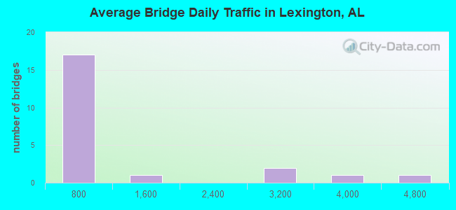
- 19,296Total average daily traffic
- 1,415Total average daily truck traffic
- 25,908Total future (year 2028) average daily traffic
- National Bridge Inventory (NBI) Registered Bridges for Lexington
- No street view available for this location
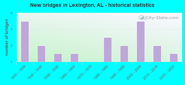
- New bridges - historical statistics
- 51930-1939
- 21940-1949
- 11950-1959
- 11960-1969
- 31980-1989
- 21990-1999
- 52000-2009
- 22010-2019
- 12020-2022
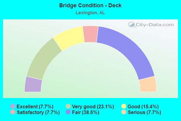
- Bridge Condition - Deck
- 7.7%Excellent
- 23.1%Very good
- 15.4%Good
- 7.7%Satisfactory
- 38.5%Fair
- 7.7%Serious
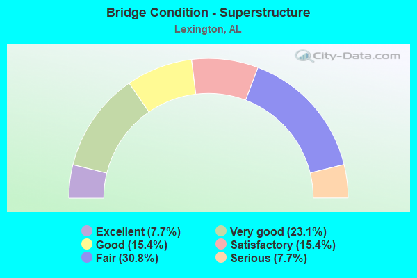
- Bridge Condition - Superstructure
- 7.7%Excellent
- 23.1%Very good
- 15.4%Good
- 15.4%Satisfactory
- 30.8%Fair
- 7.7%Serious
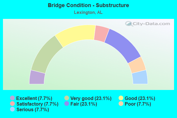
- Bridge Condition - Substructure
- 7.7%Excellent
- 23.1%Very good
- 23.1%Good
- 7.7%Satisfactory
- 23.1%Fair
- 7.7%Poor
- 7.7%Serious

- Bridge Condition - Channel
- 13.6%Very good
- 36.4%Good
- 45.5%Satisfactory
- 4.5%Fair
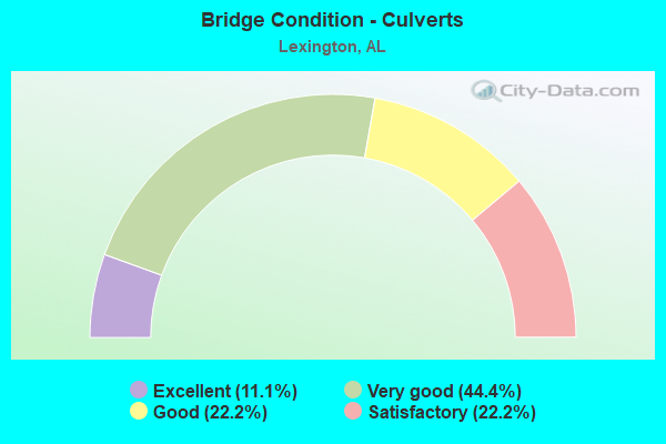
- Bridge Condition - Culverts
- 11.1%Excellent
- 44.4%Very good
- 22.2%Good
- 22.2%Satisfactory
Find on map >> Show street view
Structure Number: 1536, Location: 0.4 MI SE INT CO 59 (Lat: 34.975553, Lng: -87.331950), Route carried "on" structure: County highway , Year Built: 1937, Status: Closed, Structure Length: 5.36m (17.59ft), Average Daily Traffic: 25 (year 1989), Average Future Daily Traffic: 50 (year 2028), Features Intersected: COTTS CREEK, Facility Carried by Structure: CO. 153
Minimum Vertical Clearance: 30+ m (98+ ft), Kilometerpoint: 0.010, Lanes on structure: 1, Owner: County Highway Agency, Approaching Roadway Width: 4.9m (16.1ft), Material/Design: Steel, Design/Construction: Truss - Thru, Number Of Spans In Main Unit: 1, Number Of Approach Spans: 2, Length of Maximum Span: 18.6m (61.0ft), Curb-To-Curb Width: 3.4m (11.2ft), Out-to-Out Width: 3.6m (11.8ft)
Condition: Deck: Serious, Superstructure: Serious, Substructure: Serious, Channel: Fair, Deck Geometry: High priority of corrective action, Waterway Adequacy: Meets minimum limits, Approach Roadway Alignment: Meets minimum limits, Bridge Posting: Required (Relationship of Operating Rating to Maximum Legal Load: > 39.9% below), Length Of Structure Improvement: 6.39m (20.96ft), Designated Inspection Frequency: Every 24 months, Other Special Inspection Frequency: Every 12 months, Inspection Date: December 2008, Other Special Inspection Date: December 2009, Bridge Improvement Cost: $482,000, Roadway Improvement Cost: $48,000, Total Project Cost: $530,000 ( Estimate for 2022), Deck Structure Type: Concrete Cast-file-Place
Find on map >> Show street view
Structure Number: 1586, Location: 1 MI N OF INT. 48 * 160 (Lat: 34.998383, Lng: -87.387219), Route carried "on" structure: County highway 48, Year Built: 1937, Status: Open, Structure Length: 0.76m (2.49ft), Average Daily Traffic: 110 (year 1989), Truck Traffic: 10%, Average Future Daily Traffic: 220 (year 2028), Features Intersected: LITTLE BLUEWATER CREEK
Minimum Vertical Clearance: 30+ m (98+ ft), Kilometerpoint: 0.010, Lanes on structure: 1, Owner: County Highway Agency, Approaching Roadway Width: 7.9m (25.9ft), Skew: 1 degrees, Material/Design: Concrete, Design/Construction: Tee Beam, Number Of Spans In Main Unit: 1, Length of Maximum Span: 7.6m (24.9ft), Curb-To-Curb Width: 5.6m (18.4ft), Out-to-Out Width: 5.8m (19.0ft)
Condition: Deck: Fair, Superstructure: Fair, Substructure: Satisfactory, Channel: Satisfactory, Operating Rating: 32.7 metric tons, Method Used To Determine Operating Rating: Field evaluation and documented engineering judgment, Inventory Rating: 23.9 metric tons, Method Used To Determine Inventory Rating: Field evaluation and documented engineering judgment, Structural Evaluation: Somewhat better than minimum adequacy, Deck Geometry: High priority of corrective action, Waterway Adequacy: Somewhat better than minimum adequacy, Approach Roadway Alignment: Somewhat better than minimum adequacy, Length Of Structure Improvement: 1.41m (4.63ft), Designated Inspection Frequency: Every 24 months, Inspection Date: Febuary 2021, Bridge Improvement Cost: $183,000, Roadway Improvement Cost: $18,000, Total Project Cost: $201,000 ( Estimate for 2022), Deck Structure Type: Concrete Cast-file-Place, Wearing Surface/Protective System: Wearing Surface: Bituminous
Find on map >> Show street view
Structure Number: 1593, Location: 1.8 MI E CO 88 (Lat: 34.939897, Lng: -87.336339), Route carried "on" structure: County highway 88, Year Built: 1937, Status: Posted for load, Structure Length: 3.44m (11.29ft), Average Daily Traffic: 232 (year 2001), Truck Traffic: 10%, Average Future Daily Traffic: 337 (year 2031), Features Intersected: SECOND CREEK
Minimum Vertical Clearance: 30+ m (98+ ft), Kilometerpoint: 0.010, Lanes on structure: 2, Owner: County Highway Agency, Approaching Roadway Width: 6.7m (22.0ft), Skew: 4 degrees, Material/Design: Steel, Design/Construction: Stringer/Multi-beam, Number Of Spans In Main Unit: 1, Number Of Approach Spans: 2, Length of Maximum Span: 15.5m (50.9ft), Curb or Sidewalk Widths: Left: 0.4m (1.3ft), Right: 0.4m (1.3ft), Curb-To-Curb Width: 6.2m (20.3ft), Out-to-Out Width: 6.4m (21.0ft)
Condition: Deck: Fair, Superstructure: Fair, Substructure: Poor, Channel: Satisfactory, Operating Rating: 14.1 metric tons, Method Used To Determine Operating Rating: Load Factor (LF), Inventory Rating: 8.4 metric tons, Method Used To Determine Inventory Rating: Load Factor (LF), Structural Evaluation: High priority of replacement, Waterway Adequacy: Somewhat better than minimum adequacy, Approach Roadway Alignment: Somewhat better than minimum adequacy, Bridge Posting: Required (Relationship of Operating Rating to Maximum Legal Load: > 39.9% below), Length Of Structure Improvement: 4.34m (14.24ft), Designated Inspection Frequency: Every 24 months, Other Special Inspection Frequency: Every 12 months, Inspection Date: September 2020, Other Special Inspection Date: September 2021, Bridge Improvement Cost: $625,000, Roadway Improvement Cost: $63,000, Total Project Cost: $688,000 ( Estimate for 2022), Deck Structure Type: Concrete Cast-file-Place, Wearing Surface/Protective System: Wearing Surface: Bituminous
Find on map >> Show street view
Structure Number: 1645, Location: 1.3 MI NW INT SR 64 (Lat: 34.980606, Lng: -87.433581), Route carried "on" structure: County highway 136, Year Built: 1937, Status: Posted for load, Structure Length: 1.13m (3.71ft), Average Daily Traffic: 494 (year 2001), Truck Traffic: 10%, Average Future Daily Traffic: 734 (year 2031), Features Intersected: BLUE WATER CREEK
Minimum Vertical Clearance: 30+ m (98+ ft), Kilometerpoint: 0.010, Lanes on structure: 2, Owner: County Highway Agency, Approaching Roadway Width: 7.9m (25.9ft), Material/Design: Concrete, Design/Construction: Tee Beam, Number Of Spans In Main Unit: 2, Length of Maximum Span: 5.5m (18.0ft), Curb-To-Curb Width: 5.7m (18.7ft), Out-to-Out Width: 5.9m (19.4ft)
Condition: Deck: Fair, Superstructure: Fair, Substructure: Fair, Channel: Satisfactory, Operating Rating: 13.6 metric tons, Method Used To Determine Operating Rating: Field evaluation and documented engineering judgment, Inventory Rating: 10.9 metric tons, Method Used To Determine Inventory Rating: Field evaluation and documented engineering judgment, Structural Evaluation: Meets minimum limits, Waterway Adequacy: Better than present minimum criteria, Approach Roadway Alignment: Somewhat better than minimum adequacy, Bridge Posting: Required (Relationship of Operating Rating to Maximum Legal Load: > 39.9% below), Length Of Structure Improvement: 1.81m (5.94ft), Designated Inspection Frequency: Every 24 months, Other Special Inspection Frequency: Every 12 months, Inspection Date: Febuary 2021, Other Special Inspection Date: Febuary 2022, Bridge Improvement Cost: $235,000, Roadway Improvement Cost: $24,000, Total Project Cost: $259,000 ( Estimate for 2022), Deck Structure Type: Concrete Cast-file-Place, Wearing Surface/Protective System: Wearing Surface: Bituminous
Find on map >> Show street view
Structure Number: 1649, Location: 1 MI E * N OF SR 64 (Lat: 34.972794, Lng: -87.428089), Route carried "on" structure: County highway 159, Year Built: 1937, Status: Open, Structure Length: 0.76m (2.49ft), Average Daily Traffic: 190 (year 1989), Truck Traffic: 10%, Average Future Daily Traffic: 380 (year 2028), Features Intersected: LITTLE BLUEWATER CREEK
Minimum Vertical Clearance: 30+ m (98+ ft), Kilometerpoint: 0.010, Lanes on structure: 2, Owner: County Highway Agency, Approaching Roadway Width: 5.8m (19.0ft), Material/Design: Concrete, Design/Construction: Tee Beam, Number Of Spans In Main Unit: 1, Length of Maximum Span: 7.6m (24.9ft), Curb-To-Curb Width: 5.8m (19.0ft), Out-to-Out Width: 5.9m (19.4ft)
Condition: Deck: Fair, Superstructure: Fair, Substructure: Fair, Channel: Satisfactory, Operating Rating: 33.1 metric tons, Method Used To Determine Operating Rating: Field evaluation and documented engineering judgment, Inventory Rating: 32.7 metric tons, Method Used To Determine Inventory Rating: Field evaluation and documented engineering judgment, Structural Evaluation: Somewhat better than minimum adequacy, Waterway Adequacy: Somewhat better than minimum adequacy, Approach Roadway Alignment: Meets minimum limits, Length Of Structure Improvement: 1.41m (4.63ft), Designated Inspection Frequency: Every 24 months, Inspection Date: Febuary 2021, Bridge Improvement Cost: $183,000, Roadway Improvement Cost: $18,000, Total Project Cost: $201,000 ( Estimate for 2022), Deck Structure Type: Concrete Cast-file-Place, Wearing Surface/Protective System: Wearing Surface: Bituminous
Find on map >> Show street view
Structure Number: 3118, Location: 4 M S JCT SR 101 & SR 64 (Lat: 34.922056, Lng: -87.376361), Route carried "on" structure: State highway 101, Year Built: 1947, Status: Open, Structure Length: 0.85m (2.79ft), Average Daily Traffic: 3,600 (year 2021), Truck Traffic: 8%, Average Future Daily Traffic: 4,393 (year 2033), Design Load: H 15, Features Intersected: BRANCH
Minimum Vertical Clearance: 30+ m (98+ ft), Kilometerpoint: 53.932, Lanes on structure: 2, Owner: State Highway Agency, Approaching Roadway Width: 8.7m (28.5ft), Skew: 3 degrees, Material/Design: Concrete continuous, Design/Construction: Slab, Number Of Spans In Main Unit: 2, Length of Maximum Span: 3.0m (9.8ft), Curb-To-Curb Width: 8.5m (27.9ft), Out-to-Out Width: 11.9m (39.0ft)
Condition: Deck: Good, Superstructure: Good, Substructure: Good, Channel: Good, Operating Rating: 32.7 metric tons, Method Used To Determine Operating Rating: Field evaluation and documented engineering judgment, Inventory Rating: 24.5 metric tons, Method Used To Determine Inventory Rating: Field evaluation and documented engineering judgment, Structural Evaluation: Equal to present minimum criteria, Deck Geometry: Meets minimum limits, Waterway Adequacy: Better than present minimum criteria, Approach Roadway Alignment: Better than present minimum criteria, Length Of Structure Improvement: 1.51m (4.95ft), Designated Inspection Frequency: Every 24 months, Inspection Date: June 2021, Bridge Improvement Cost: $405,000, Roadway Improvement Cost: $41,000, Total Project Cost: $446,000 ( Estimate for 2022), Deck Structure Type: Concrete Cast-file-Place
Find on map >> Show street view
Structure Number: 312, Location: 2 M N JCT SR 101 & SR 64 (Lat: 35.000025, Lng: -87.359500), Route carried "on" structure: State highway 101, Year Built: 1947, Status: Open, Structure Length: 0.76m (2.49ft), Average Daily Traffic: 1,220 (year 2021), Truck Traffic: 10%, Average Future Daily Traffic: 1,489 (year 2033), Design Load: H 15, Features Intersected: Crossroads Branch
Minimum Vertical Clearance: 30+ m (98+ ft), Kilometerpoint: 62.745, Lanes on structure: 2, Owner: State Highway Agency, Approaching Roadway Width: 8.5m (27.9ft), Material/Design: Concrete continuous, Design/Construction: Slab, Number Of Spans In Main Unit: 2, Length of Maximum Span: 3.0m (9.8ft), Curb-To-Curb Width: 8.5m (27.9ft), Out-to-Out Width: 12.6m (41.3ft)
Condition: Deck: Satisfactory, Superstructure: Satisfactory, Substructure: Good, Channel: Satisfactory, Operating Rating: 32.7 metric tons, Method Used To Determine Operating Rating: Field evaluation and documented engineering judgment, Inventory Rating: 24.5 metric tons, Method Used To Determine Inventory Rating: Field evaluation and documented engineering judgment, Structural Evaluation: Equal to present minimum criteria, Deck Geometry: Somewhat better than minimum adequacy, Waterway Adequacy: Better than present minimum criteria, Approach Roadway Alignment: Better than present minimum criteria, Length Of Structure Improvement: 1.41m (4.63ft), Designated Inspection Frequency: Every 24 months, Inspection Date: June 2021, Bridge Improvement Cost: $396,000, Roadway Improvement Cost: $40,000, Total Project Cost: $436,000 ( Estimate for 2022), Deck Structure Type: Concrete Cast-file-Place
Find on map >> Show street view
Structure Number: 5938, Location: 1.2 MI N CO RT 50 (Lat: 34.923900, Lng: -87.339489), Route carried "on" structure: County highway 51, Year Built: 1957, Status: Posted for load, Structure Length: 3.29m (10.79ft), Average Daily Traffic: 150 (year 1989), Truck Traffic: 10%, Average Future Daily Traffic: 300 (year 2031), Features Intersected: SECOND CREEK
Minimum Vertical Clearance: 30+ m (98+ ft), Kilometerpoint: 0.010, Lanes on structure: 2, Owner: County Highway Agency, Approaching Roadway Width: 7.3m (24.0ft), Material/Design: Steel, Design/Construction: Stringer/Multi-beam, Number Of Spans In Main Unit: 5, Length of Maximum Span: 9.1m (29.9ft), Curb or Sidewalk Widths: Left: 0.2m (0.7ft), Right: 0.2m (0.7ft), Curb-To-Curb Width: 6.1m (20.0ft), Out-to-Out Width: 6.1m (20.0ft)
Condition: Deck: Fair, Superstructure: Satisfactory, Substructure: Fair, Channel: Satisfactory, Operating Rating: 22.1 metric tons, Method Used To Determine Operating Rating: Allowable Stress (AS), Inventory Rating: 13.5 metric tons, Method Used To Determine Inventory Rating: Allowable Stress (AS), Structural Evaluation: Meets minimum limits, Waterway Adequacy: Somewhat better than minimum adequacy, Approach Roadway Alignment: Better than present minimum criteria, Bridge Posting: Required (Relationship of Operating Rating to Maximum Legal Load: > 39.9% below), Length Of Structure Improvement: 4.17m (13.68ft), Designated Inspection Frequency: Every 24 months, Other Special Inspection Frequency: Every 12 months, Inspection Date: Febuary 2021, Other Special Inspection Date: Febuary 2022, Bridge Improvement Cost: $571,000, Roadway Improvement Cost: $57,000, Total Project Cost: $628,000 ( Estimate for 2022), Deck Structure Type: Concrete Precast Panels
Find on map >> Show street view
Structure Number: 9405, Location: 0.6 MI N INT CO 50 (Lat: 34.912469, Lng: -87.393256), Route carried "on" structure: County highway 67, Year Built: 1967, Status: Open, Structure Length: 1.56m (5.12ft), Average Daily Traffic: 235 (year 1989), Truck Traffic: 10%, Average Future Daily Traffic: 470 (year 2030), Features Intersected: MILL CREEK
Minimum Vertical Clearance: 30+ m (98+ ft), Kilometerpoint: 0.010, Lanes on structure: 2, Owner: County Highway Agency, Approaching Roadway Width: 6.1m (20.0ft), Skew: 1 degrees, Material/Design: Concrete, Design/Construction: Culvert, Number Of Spans In Main Unit: 4, Length of Maximum Span: 3.9m (12.8ft), Curb or Sidewalk Widths: Left: 0.3m (1.0ft), Right: 0.3m (1.0ft), Curb-To-Curb Width: 8.8m (28.9ft), Out-to-Out Width: 9.3m (30.5ft)
Condition: Channel: Satisfactory, Culverts: Satisfactory, Operating Rating: 41.9 metric tons, Method Used To Determine Operating Rating: Load Factor (LF), Inventory Rating: 25.1 metric tons, Method Used To Determine Inventory Rating: Load Factor (LF), Structural Evaluation: Equal to present minimum criteria, Waterway Adequacy: Better than present minimum criteria, Approach Roadway Alignment: Equal to present minimum criteria, Length Of Structure Improvement: 2.25m (7.38ft), Designated Inspection Frequency: Every 24 months, Inspection Date: Febuary 2021, Bridge Improvement Cost: $415,000, Roadway Improvement Cost: $42,000, Total Project Cost: $457,000 ( Estimate for 2022), Deck Structure Type: Concrete Cast-file-Place
Find on map >> Show street view
Structure Number: 12599, Location: 4 MI W JCT SR64 & SR101 (Lat: 34.957139, Lng: -87.433750), Route carried "on" structure: State highway 64, Year Built: 1981, Status: Open, Structure Length: 13.56m (44.49ft), Average Daily Traffic: 2,670 (year 2018), Truck Traffic: 6%, Average Future Daily Traffic: 3,660 (year 2033), Design Load: HS 20, Features Intersected: BLUEWATER CREEK
Minimum Vertical Clearance: 30+ m (98+ ft), Kilometerpoint: 9.775, Lanes on structure: 2, Owner: State Highway Agency, Approaching Roadway Width: 7.3m (24.0ft), Material/Design: Steel continuous, Design/Construction: Stringer/Multi-beam, Number Of Spans In Main Unit: 7, Length of Maximum Span: 24.4m (80.1ft), Curb or Sidewalk Widths: Left: 0.2m (0.7ft), Right: 0.2m (0.7ft), Curb-To-Curb Width: 12.2m (40.0ft), Out-to-Out Width: 13.1m (43.0ft)
Condition: Deck: Good, Superstructure: Good, Substructure: Good, Channel: Satisfactory, Operating Rating: 58.4 metric tons, Method Used To Determine Operating Rating: Load Factor (LF), Inventory Rating: 35.0 metric tons, Method Used To Determine Inventory Rating: Load Factor (LF), Structural Evaluation: Better than present minimum criteria, Deck Geometry: Equal to present minimum criteria, Waterway Adequacy: Equal to present desirable criteria, Approach Roadway Alignment: Equal to present desirable criteria, Length Of Structure Improvement: 14.37m (47.15ft), Designated Inspection Frequency: Every 24 months, Inspection Date: July 2020, Bridge Improvement Cost: $4,237,000, Roadway Improvement Cost: $424,000, Total Project Cost: $4,661,000 ( Estimate for 2022), Deck Structure Type: Concrete Cast-file-Place
Find on map >> Show street view
Structure Number: 1337, Location: 2.4 M N JCT SR 101 & SR 2 (Lat: 34.887750, Lng: -87.388583), Route carried "on" structure: State highway 101, Year Built: 1984, Status: Open, Structure Length: 1.16m (3.81ft), Average Daily Traffic: 4,561 (year 2021), Truck Traffic: 8%, Average Future Daily Traffic: 5,565 (year 2033), Design Load: HS 20, Features Intersected: SPRINGFIELD BRANCH
Minimum Vertical Clearance: 30+ m (98+ ft), Kilometerpoint: 49.959, Lanes on structure: 2, Owner: State Highway Agency, Approaching Roadway Width: 7.3m (24.0ft), Skew: 2 degrees, Material/Design: Concrete, Design/Construction: Culvert, Number Of Spans In Main Unit: 3, Length of Maximum Span: 3.0m (9.8ft), Curb-To-Curb Width: 12.2m (40.0ft), Out-to-Out Width: 16.5m (54.1ft)
Condition: Channel: Good, Culverts: Good, Operating Rating: 66.2 metric tons, Method Used To Determine Operating Rating: Load Factor (LF), Inventory Rating: 39.9 metric tons, Method Used To Determine Inventory Rating: Load Factor (LF), Structural Evaluation: Better than present minimum criteria, Deck Geometry: Equal to present minimum criteria, Waterway Adequacy: Equal to present desirable criteria, Approach Roadway Alignment: Equal to present desirable criteria, Length Of Structure Improvement: 1.84m (6.04ft), Designated Inspection Frequency: Every 24 months, Inspection Date: June 2021, Bridge Improvement Cost: $636,000, Roadway Improvement Cost: $64,000, Total Project Cost: $700,000 ( Estimate for 2022)
Find on map >> Show street view
Structure Number: 1368, Location: 2 MI NE LEXINGTON (Lat: 34.980447, Lng: -87.400694), Route carried "on" structure: County highway 136, Year Built: 1985, Status: Open, Structure Length: 1.10m (3.61ft), Average Daily Traffic: 250 (year 1989), Truck Traffic: 10%, Average Future Daily Traffic: 500 (year 2030), Design Load: HS 20, Features Intersected: LITTLE BLUEWATER CREEK
Minimum Vertical Clearance: 30+ m (98+ ft), Kilometerpoint: 0.010, Lanes on structure: 2, Owner: County Highway Agency, Approaching Roadway Width: 8.5m (27.9ft), Skew: 4 degrees, Material/Design: Concrete, Design/Construction: Culvert, Number Of Spans In Main Unit: 2, Length of Maximum Span: 3.0m (9.8ft), Curb-To-Curb Width: 17.5m (57.4ft), Out-to-Out Width: 18.0m (59.1ft)
Condition: Channel: Satisfactory, Culverts: Satisfactory, Operating Rating: 88.9 metric tons, Method Used To Determine Operating Rating: Load Factor (LF), Inventory Rating: 60.1 metric tons, Method Used To Determine Inventory Rating: Load Factor (LF), Structural Evaluation: Equal to present minimum criteria, Waterway Adequacy: Better than present minimum criteria, Approach Roadway Alignment: Equal to present minimum criteria, Length Of Structure Improvement: 1.77m (5.81ft), Designated Inspection Frequency: Every 24 months, Inspection Date: Febuary 2021, Bridge Improvement Cost: $605,000, Roadway Improvement Cost: $61,000, Total Project Cost: $666,000 ( Estimate for 2022), Wearing Surface/Protective System: Wearing Surface: Bituminous
Find on map >> Show street view
Structure Number: 16537, Location: 1.7MI E SR 101 (Lat: 34.906489, Lng: -87.350008), Route carried "on" structure: County highway 50, Year Built: 1994, Status: Open, Structure Length: 1.09m (3.58ft), Average Daily Traffic: 260 (year 1989), Truck Traffic: 10%, Average Future Daily Traffic: 300 (year 2028), Design Load: HS 20, Features Intersected: CORUM HOLLOW CREEK
Minimum Vertical Clearance: 30+ m (98+ ft), Kilometerpoint: 0.010, Lanes on structure: 2, Owner: County Highway Agency, Approaching Roadway Width: 6.1m (20.0ft), Skew: 3 degrees, Material/Design: Concrete, Design/Construction: Culvert, Number Of Spans In Main Unit: 3, Length of Maximum Span: 3.5m (11.5ft), Curb or Sidewalk Widths: Left: 0.3m (1.0ft), Right: 0.3m (1.0ft), Curb-To-Curb Width: 12.2m (40.0ft), Out-to-Out Width: 12.7m (41.7ft)
Condition: Channel: Good, Culverts: Good, Operating Rating: 62.1 metric tons, Method Used To Determine Operating Rating: Load Factor (LF), Inventory Rating: 37.3 metric tons, Method Used To Determine Inventory Rating: Load Factor (LF), Structural Evaluation: Better than present minimum criteria, Deck Geometry: Superior to present desirable criteria, Waterway Adequacy: Better than present minimum criteria, Approach Roadway Alignment: Somewhat better than minimum adequacy, Length Of Structure Improvement: 1.76m (5.77ft), Designated Inspection Frequency: Every 24 months, Inspection Date: April 2021, Bridge Improvement Cost: $487,000, Roadway Improvement Cost: $49,000, Total Project Cost: $536,000 ( Estimate for 2022), Deck Structure Type: Concrete Cast-file-Place
Find on map >> Show street view
Structure Number: 1713, Location: 1.5 MI NORTH OF AL 64 (Lat: 34.980075, Lng: -87.345453), Route carried "on" structure: County highway 59, Year Built: 1999, Status: Open, Structure Length: 6.00m (19.69ft), Average Daily Traffic: 297 (year 2001), Truck Traffic: 10%, Average Future Daily Traffic: 416 (year 2028), Design Load: HS 20, Features Intersected: SECOND CREEK
Minimum Vertical Clearance: 30+ m (98+ ft), Kilometerpoint: 0.010, Lanes on structure: 2, Owner: County Highway Agency, Approaching Roadway Width: 6.0m (19.7ft), Material/Design: Prestressed concrete, Design/Construction: Stringer/Multi-beam, Number Of Spans In Main Unit: 5, Length of Maximum Span: 12.0m (39.4ft), Curb or Sidewalk Widths: Left: 0.4m (1.3ft), Right: 0.4m (1.3ft), Curb-To-Curb Width: 8.0m (26.2ft), Out-to-Out Width: 8.8m (28.9ft)
Condition: Deck: Very good, Superstructure: Very good, Substructure: Very good, Channel: Good, Operating Rating: 62.5 metric tons, Method Used To Determine Operating Rating: Load Factor (LF), Inventory Rating: 56.7 metric tons, Method Used To Determine Inventory Rating: Load Factor (LF), Structural Evaluation: Equal to present desirable criteria, Deck Geometry: Somewhat better than minimum adequacy, Waterway Adequacy: Superior to present desirable criteria, Approach Roadway Alignment: Better than present minimum criteria, Length Of Structure Improvement: 7.04m (23.10ft), Designated Inspection Frequency: Every 24 months, Inspection Date: May 2020, Bridge Improvement Cost: $1,352,000, Roadway Improvement Cost: $135,000, Total Project Cost: $1,487,000 ( Estimate for 2022), Deck Structure Type: Concrete Cast-file-Place
Find on map >> Show street view
Structure Number: 17913, Location: 1 MI. EAST ALA 101 (Lat: 34.907581, Lng: -87.363128), Route carried "on" structure: County highway 50, Year Built: 2002, Status: Open, Structure Length: 7.80m (25.59ft), Average Daily Traffic: 270 (year 2000), Average Future Daily Traffic: 400 (year 2030), Design Load: HS 20, Features Intersected: SECOND CREEK
Minimum Vertical Clearance: 30+ m (98+ ft), Kilometerpoint: 0.010, Lanes on structure: 2, Owner: County Highway Agency, Approaching Roadway Width: 6.1m (20.0ft), Material/Design: Prestressed concrete, Design/Construction: Stringer/Multi-beam, Number Of Spans In Main Unit: 5, Length of Maximum Span: 18.0m (59.1ft), Curb or Sidewalk Widths: Left: 0.4m (1.3ft), Right: 0.4m (1.3ft), Curb-To-Curb Width: 9.0m (29.5ft), Out-to-Out Width: 9.8m (32.2ft)
Condition: Deck: Very good, Superstructure: Very good, Substructure: Very good, Channel: Very good, Operating Rating: 55.3 metric tons, Method Used To Determine Operating Rating: Load Factor (LF), Inventory Rating: 33.2 metric tons, Method Used To Determine Inventory Rating: Load Factor (LF), Structural Evaluation: Equal to present desirable criteria, Deck Geometry: Equal to present minimum criteria, Waterway Adequacy: Superior to present desirable criteria, Approach Roadway Alignment: Equal to present desirable criteria, Length Of Structure Improvement: 8.81m (28.90ft), Designated Inspection Frequency: Every 24 months, Inspection Date: May 2020, Bridge Improvement Cost: $1,934,000, Roadway Improvement Cost: $193,000, Total Project Cost: $2,127,000 ( Estimate for 2022), Deck Structure Type: Concrete Cast-file-Place
Find on map >> Show street view
Structure Number: 17917, Location: 1.4 MI E S.R. #101 (Lat: 34.907506, Lng: -87.356825), Route carried "on" structure: County highway 50, Year Built: 2000, Status: Open, Structure Length: 1.16m (3.81ft), Average Daily Traffic: 120 (year 1989), Average Future Daily Traffic: 178 (year 2030), Design Load: HS 20, Features Intersected: CORUM HOLLOW BRANCH
Minimum Vertical Clearance: 30+ m (98+ ft), Kilometerpoint: 0.010, Lanes on structure: 2, Owner: County Highway Agency, Approaching Roadway Width: 7.3m (24.0ft), Skew: 4 degrees, Material/Design: Concrete, Design/Construction: Culvert, Number Of Spans In Main Unit: 3, Length of Maximum Span: 3.3m (10.8ft), Curb or Sidewalk Widths: Left: 0.2m (0.7ft), Right: 0.2m (0.7ft), Curb-To-Curb Width: 7.7m (25.3ft), Out-to-Out Width: 8.2m (26.9ft)
Condition: Channel: Satisfactory, Culverts: Very good, Operating Rating: 67.1 metric tons, Method Used To Determine Operating Rating: Load Factor (LF), Inventory Rating: 40.3 metric tons, Method Used To Determine Inventory Rating: Load Factor (LF), Structural Evaluation: Equal to present desirable criteria, Deck Geometry: Somewhat better than minimum adequacy, Waterway Adequacy: Better than present minimum criteria, Approach Roadway Alignment: Equal to present desirable criteria, Length Of Structure Improvement: 1.83m (6.00ft), Designated Inspection Frequency: Every 24 months, Inspection Date: April 2021, Bridge Improvement Cost: $402,000, Roadway Improvement Cost: $40,000, Total Project Cost: $442,000 ( Estimate for 2022)
Find on map >> Show street view
Structure Number: 18012, Location: 2 MI E JCT SR64 & SR101 (Lat: 34.969611, Lng: -87.333944), Route carried "on" structure: State highway 64, Year Built: 2008, Status: Open, Structure Length: 8.84m (29.00ft), Average Daily Traffic: 2,720 (year 2020), Truck Traffic: 6%, Average Future Daily Traffic: 3,729 (year 2033), Design Load: HS 20, Features Intersected: SECOND CREEK
Minimum Vertical Clearance: 30+ m (98+ ft), Kilometerpoint: 19.500, Lanes on structure: 2, Owner: State Highway Agency, Approaching Roadway Width: 14.0m (45.9ft), Material/Design: Prestressed concrete, Design/Construction: Stringer/Multi-beam, Number Of Spans In Main Unit: 5, Length of Maximum Span: 21.3m (69.9ft), Curb-To-Curb Width: 13.4m (44.0ft), Out-to-Out Width: 14.2m (46.6ft)
Condition: Deck: Very good, Superstructure: Very good, Substructure: Very good, Channel: Very good, Operating Rating: 57.1 metric tons, Method Used To Determine Operating Rating: Load Factor (LF), Inventory Rating: 33.6 metric tons, Method Used To Determine Inventory Rating: Load Factor (LF), Structural Evaluation: Equal to present desirable criteria, Deck Geometry: Better than present minimum criteria, Waterway Adequacy: Superior to present desirable criteria, Approach Roadway Alignment: Superior to present desirable criteria, Length Of Structure Improvement: 9.82m (32.22ft), Designated Inspection Frequency: Every 24 months, Inspection Date: July 2020, Bridge Improvement Cost: $3,096,000, Roadway Improvement Cost: $310,000, Total Project Cost: $3,406,000 ( Estimate for 2022), Deck Structure Type: Concrete Cast-file-Place
Find on map >> Show street view
Structure Number: 19455, Location: 0.4 MI N JCT CO 136 (Lat: 34.984878, Lng: -87.429442), Route carried "on" structure: County highway 159, Year Built: 2004, Status: Open, Structure Length: 1.05m (3.44ft), Average Daily Traffic: 90 (year 2004), Average Future Daily Traffic: 110 (year 2028), Design Load: HS 20, Features Intersected: KEATY BRANCH
Minimum Vertical Clearance: 30+ m (98+ ft), Kilometerpoint: 0.000, Lanes on structure: 2, Owner: County Highway Agency, Approaching Roadway Width: 6.1m (20.0ft), Skew: 4 degrees, Material/Design: Concrete, Design/Construction: Culvert, Number Of Spans In Main Unit: 2, Length of Maximum Span: 5.2m (17.1ft), Curb or Sidewalk Widths: Left: 0.3m (1.0ft), Right: 0.3m (1.0ft), Curb-To-Curb Width: 12.0m (39.4ft), Out-to-Out Width: 12.5m (41.0ft)
Condition: Channel: Good, Culverts: Very good, Operating Rating: 88.9 metric tons, Method Used To Determine Operating Rating: Load Factor (LF), Inventory Rating: 56.6 metric tons, Method Used To Determine Inventory Rating: Load Factor (LF), Structural Evaluation: Equal to present desirable criteria, Deck Geometry: Superior to present desirable criteria, Waterway Adequacy: Equal to present minimum criteria, Approach Roadway Alignment: Equal to present minimum criteria, Length Of Structure Improvement: 1.73m (5.68ft), Designated Inspection Frequency: Every 24 months, Inspection Date: Febuary 2021, Bridge Improvement Cost: $580,000, Roadway Improvement Cost: $58,000, Total Project Cost: $638,000 ( Estimate for 2022), Deck Structure Type: Concrete Cast-file-Place
Find on map >> Show street view
Structure Number: 19768, Location: 0.3 MI S INT AL 101 (Lat: 34.964867, Lng: -87.368606), Route carried "on" structure: County highway 51, Year Built: 2006, Status: Open, Structure Length: 1.09m (3.58ft), Average Daily Traffic: 766 (year 2001), Average Future Daily Traffic: 1,138 (year 2030), Design Load: HS 20, Features Intersected: MILL CREEK
Minimum Vertical Clearance: 30+ m (98+ ft), Kilometerpoint: 0.010, Lanes on structure: 2, Owner: County Highway Agency, Approaching Roadway Width: 6.1m (20.0ft), Skew: 4 degrees, Material/Design: Concrete, Design/Construction: Culvert, Number Of Spans In Main Unit: 2, Length of Maximum Span: 5.2m (17.1ft), Curb or Sidewalk Widths: Left: 0.3m (1.0ft), Right: 0.3m (1.0ft), Curb-To-Curb Width: 8.1m (26.6ft), Out-to-Out Width: 8.6m (28.2ft)
Condition: Channel: Good, Culverts: Very good, Operating Rating: 73.7 metric tons, Method Used To Determine Operating Rating: Load Factor (LF), Inventory Rating: 44.2 metric tons, Method Used To Determine Inventory Rating: Load Factor (LF), Structural Evaluation: Equal to present desirable criteria, Deck Geometry: Somewhat better than minimum adequacy, Waterway Adequacy: Equal to present minimum criteria, Approach Roadway Alignment: Meets minimum limits, Length Of Structure Improvement: 1.77m (5.81ft), Designated Inspection Frequency: Every 24 months, Inspection Date: January 2021, Bridge Improvement Cost: $409,000, Roadway Improvement Cost: $41,000, Total Project Cost: $450,000 ( Estimate for 2022)
Find on map >> Show street view
Structure Number: 20387, Location: 0.7 MI W INT ST RT 101 (Lat: 34.929228, Lng: -87.389428), Route carried "on" structure: County highway 104, Year Built: 2010, Status: Open, Structure Length: 1.75m (5.74ft), Average Daily Traffic: 254 (year 2001), Truck Traffic: 10%, Average Future Daily Traffic: 377 (year 2032), Design Load: HS 20, Features Intersected: MILL CREEK
Minimum Vertical Clearance: 30+ m (98+ ft), Kilometerpoint: 0.010, Lanes on structure: 2, Owner: County Highway Agency, Approaching Roadway Width: 6.1m (20.0ft), Skew: 3 degrees, Material/Design: Concrete, Design/Construction: Culvert, Number Of Spans In Main Unit: 4, Length of Maximum Span: 3.7m (12.1ft), Curb or Sidewalk Widths: Left: 0.3m (1.0ft), Right: 0.3m (1.0ft), Curb-To-Curb Width: 8.7m (28.5ft), Out-to-Out Width: 9.2m (30.2ft)
Condition: Channel: Good, Culverts: Very good, Operating Rating: 66.7 metric tons, Method Used To Determine Operating Rating: Load Factor (LF), Inventory Rating: 40.0 metric tons, Method Used To Determine Inventory Rating: Load Factor (LF), Structural Evaluation: Equal to present desirable criteria, Deck Geometry: Equal to present minimum criteria, Waterway Adequacy: Better than present minimum criteria, Approach Roadway Alignment: Better than present minimum criteria, Length Of Structure Improvement: 2.46m (8.07ft), Designated Inspection Frequency: Every 24 months, Inspection Date: September 2020, Bridge Improvement Cost: $497,000, Roadway Improvement Cost: $50,000, Total Project Cost: $547,000 ( Estimate for 2022)
Find on map >> Show street view
Structure Number: 21014, Location: 1.4 mi N. Int SR 101 (Lat: 34.993386, Lng: -87.350708), Route carried "on" structure: County highway 489, Year Built: 2016, Status: Open, Structure Length: 2.72m (8.92ft), Average Daily Traffic: 414 (year 2016), Truck Traffic: 9%, Average Future Daily Traffic: 615 (year 2035), Design Load: HS 20, Features Intersected: Second Creek
Minimum Vertical Clearance: 30+ m (98+ ft), Kilometerpoint: 0.010, Lanes on structure: 2, Owner: County Highway Agency, Approaching Roadway Width: 3.0m (9.8ft), Material/Design: Concrete, Design/Construction: Culvert, Number Of Spans In Main Unit: 6, Length of Maximum Span: 4.3m (14.1ft), Curb-To-Curb Width: 6.1m (20.0ft), Out-to-Out Width: 14.6m (47.9ft)
Condition: Channel: Very good, Culverts: Excellent, Operating Rating: 53.6 metric tons, Method Used To Determine Operating Rating: Load Factor (LF), Inventory Rating: 32.1 metric tons, Method Used To Determine Inventory Rating: Load Factor (LF), Structural Evaluation: Better than present minimum criteria, Deck Geometry: High priority of corrective action, Waterway Adequacy: Equal to present desirable criteria, Approach Roadway Alignment: Equal to present minimum criteria, Length Of Structure Improvement: 3.64m (11.94ft), Designated Inspection Frequency: Every 24 months, Inspection Date: July 2021, Bridge Improvement Cost: $1,871,000, Roadway Improvement Cost: $187,000, Total Project Cost: $2,058,000 ( Estimate for 2022), Deck Structure Type: Concrete Cast-file-Place
Find on map >> Show street view
Structure Number: 21405, Location: 1 mi East SR 101 (Lat: 34.885544, Lng: -87.373703), Route carried "on" structure: County highway 76, Year Built: 2020, Status: Open, Structure Length: 6.71m (22.01ft), Average Daily Traffic: 368 (year 2018), Truck Traffic: 10%, Average Future Daily Traffic: 547 (year 2038), Design Load: HS 20, Features Intersected: second creek
Minimum Vertical Clearance: 30+ m (98+ ft), Kilometerpoint: 0.010, Lanes on structure: 2, Owner: County Highway Agency, Approaching Roadway Width: 6.1m (20.0ft), Skew: 1 degrees, Material/Design: Concrete, Design/Construction: Stringer/Multi-beam, Number Of Spans In Main Unit: 3, Number Of Approach Spans: 2, Length of Maximum Span: 30.5m (100.1ft), Curb or Sidewalk Widths: Left: 0.4m (1.3ft), Right: 0.4m (1.3ft), Curb-To-Curb Width: 7.2m (23.6ft), Out-to-Out Width: 9.4m (30.8ft)
Condition: Deck: Excellent, Superstructure: Excellent, Substructure: Excellent, Channel: Good, Operating Rating: 81.6 metric tons, Method Used To Determine Operating Rating: Load Factor (LF), Inventory Rating: 34.2 metric tons, Method Used To Determine Inventory Rating: Load Factor (LF), Structural Evaluation: Superior to present desirable criteria, Deck Geometry: Meets minimum limits, Waterway Adequacy: Equal to present minimum criteria, Approach Roadway Alignment: Somewhat better than minimum adequacy, Length Of Structure Improvement: 7.74m (25.39ft), Designated Inspection Frequency: Every 24 months, Inspection Date: May 2020, Bridge Improvement Cost: $1,593,000, Roadway Improvement Cost: $159,000, Total Project Cost: $1,752,000 ( Estimate for 2022), Deck Structure Type: Concrete Cast-file-Place, Wearing Surface/Protective System: Wearing Surface: Monolithic Concrete