Bridge Statistics for Lexington, New York (NY)
Condition, Traffic, Stress, Structural Evaluation, Project Costs
- National Bridge Inventory (NBI) Statistics
- 22Number of bridges
- 180ft / 54.8mTotal length
- $29,008,000Total costs
- 3,800Total average daily traffic
- 313Total average daily truck traffic
- 4,360Total future (year 2036) average daily traffic
- National Bridge Inventory (NBI) Registered Bridges for Lexington
- No street view available for this location
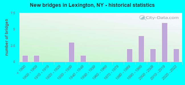
- New bridges - historical statistics
- 1Before 1900
- 11900-1909
- 31930-1939
- 11940-1949
- 21980-1989
- 41990-1999
- 22000-2009
- 62010-2019
- 22020-2022
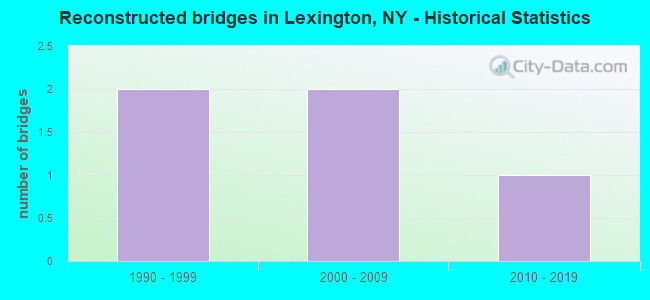
- Reconstructed bridges - Historical Statistics
- 21990-1999
- 22000-2009
- 12010-2019
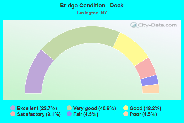
- Bridge Condition - Deck
- 22.7%Excellent
- 40.9%Very good
- 18.2%Good
- 9.1%Satisfactory
- 4.5%Fair
- 4.5%Poor
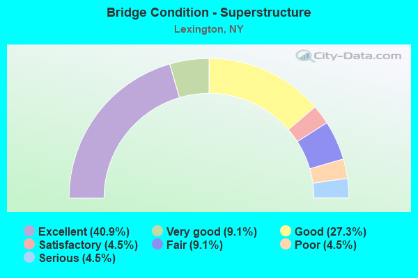
- Bridge Condition - Superstructure
- 40.9%Excellent
- 9.1%Very good
- 27.3%Good
- 4.5%Satisfactory
- 9.1%Fair
- 4.5%Poor
- 4.5%Serious
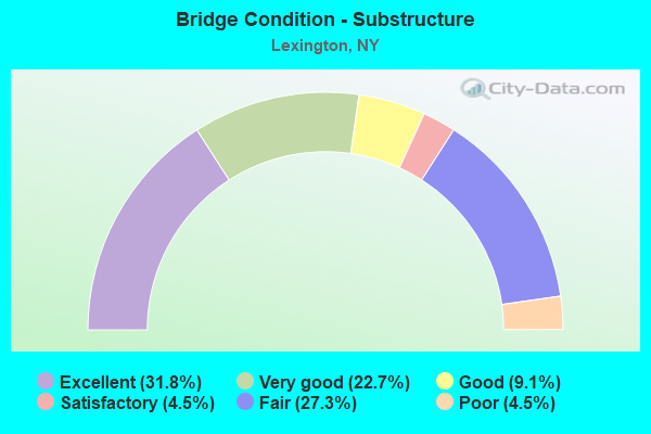
- Bridge Condition - Substructure
- 31.8%Excellent
- 22.7%Very good
- 9.1%Good
- 4.5%Satisfactory
- 27.3%Fair
- 4.5%Poor
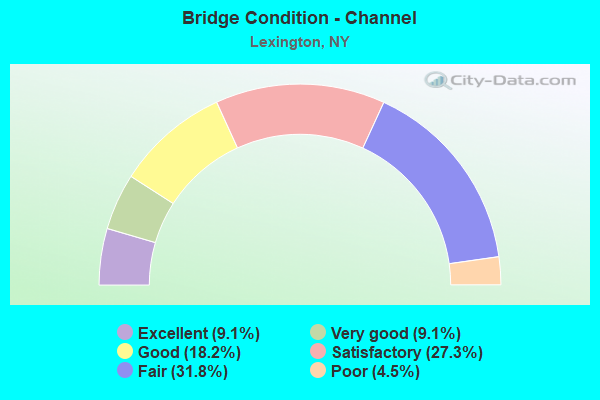
- Bridge Condition - Channel
- 9.1%Excellent
- 9.1%Very good
- 18.2%Good
- 27.3%Satisfactory
- 31.8%Fair
- 4.5%Poor
Find on map >> Show street view
Structure Number: 102519, Location: RT 42 4.6 MI N ULSTER CO (Lat: 42.211864, Lng: -74.386925), Route carried "on" structure: State highway 42, Year Built: 2011, Status: Open, Structure Length: 3.11m (10.20ft), Average Daily Traffic: 669 (year 2016), Truck Traffic: 9%, Average Future Daily Traffic: 697 (year 2040), Design Load: HL 93, Features Intersected: WESTKILL CREEK
Minimum Vertical Clearance: 30+ m (98+ ft), Kilometerpoint: 7.450, Lanes on structure: 2, Base Highway Network: Yes, Owner: State Highway Agency, Approaching Roadway Width: 9.1m (29.9ft), Material/Design: Steel, Design/Construction: Stringer/Multi-beam, Number Of Spans In Main Unit: 1, Length of Maximum Span: 30.5m (100.1ft), Curb-To-Curb Width: 9.1m (29.9ft), Out-to-Out Width: 10.1m (33.1ft)
Condition: Deck: Very good, Superstructure: Very good, Substructure: Very good, Channel: Satisfactory, Inventory Rating: 73.5 metric tons, Method Used To Determine Inventory Rating: Load Factor (LF), Structural Evaluation: Equal to present desirable criteria, Deck Geometry: Equal to present minimum criteria, Waterway Adequacy: Equal to present minimum criteria, Approach Roadway Alignment: Equal to present desirable criteria, Length Of Structure Improvement: 3.10m (10.17ft), Designated Inspection Frequency: Every 24 months, Inspection Date: May 2021, Bridge Improvement Cost: $720,000, Roadway Improvement Cost: $422,000, Total Project Cost: $1,142,000 ( Estimate for 2021), Deck Structure Type: Concrete Precast Panels, Wearing Surface/Protective System: Wearing Surface: Integral Concrete
Find on map >> Show street view
Structure Number: 10252, Location: RT 42 6.4 MI N ULSTER CO (Lat: 42.233142, Lng: -74.392053), Route carried "on" structure: State highway 42, Year Built: 2011, Status: Open, Structure Length: 4.63m (15.19ft), Average Daily Traffic: 669 (year 2016), Truck Traffic: 9%, Average Future Daily Traffic: 697 (year 2040), Design Load: HL 93, Features Intersected: WEST KILL
Minimum Vertical Clearance: 30+ m (98+ ft), Kilometerpoint: 10.072, Lanes on structure: 2, Base Highway Network: Yes, Owner: State Highway Agency, Approaching Roadway Width: 9.1m (29.9ft), Skew: 3 degrees, Material/Design: Steel, Design/Construction: Stringer/Multi-beam, Number Of Spans In Main Unit: 1, Length of Maximum Span: 45.7m (149.9ft), Curb-To-Curb Width: 9.1m (29.9ft), Out-to-Out Width: 10.1m (33.1ft)
Condition: Deck: Excellent, Superstructure: Excellent, Substructure: Very good, Channel: Good, Inventory Rating: 66.2 metric tons, Method Used To Determine Inventory Rating: Load Factor (LF), Structural Evaluation: Equal to present desirable criteria, Deck Geometry: Equal to present minimum criteria, Waterway Adequacy: Somewhat better than minimum adequacy, Approach Roadway Alignment: Meets minimum limits, Length Of Structure Improvement: 4.63m (15.19ft), Designated Inspection Frequency: Every 24 months, Inspection Date: May 2020, Bridge Improvement Cost: $1,157,000, Roadway Improvement Cost: $677,000, Total Project Cost: $1,834,000 ( Estimate for 2021), Deck Structure Type: Concrete Precast Panels, Wearing Surface/Protective System: Wearing Surface: Integral Concrete
Find on map >> Show street view
Structure Number: 102521, Location: RT 42 7.2 MI N ULSTER CO (Lat: 42.244864, Lng: -74.381697), Route carried "on" structure: State highway 42, Year Built: 2017, Status: Open, Structure Length: 4.33m (14.21ft), Average Daily Traffic: 669 (year 2016), Truck Traffic: 9%, Average Future Daily Traffic: 697 (year 2040), Design Load: HL 93, Features Intersected: WEST KILL CREEK
Minimum Vertical Clearance: 30+ m (98+ ft), Kilometerpoint: 11.649, Lanes on structure: 2, Base Highway Network: Yes, Owner: State Highway Agency, Approaching Roadway Width: 8.5m (27.9ft), Skew: 5 degrees, Material/Design: Steel, Design/Construction: Stringer/Multi-beam, Number Of Spans In Main Unit: 1, Length of Maximum Span: 42.7m (140.1ft), Curb-To-Curb Width: 8.5m (27.9ft), Out-to-Out Width: 9.5m (31.2ft)
Condition: Deck: Very good, Superstructure: Excellent, Substructure: Excellent, Channel: Excellent, Inventory Rating: 61.7 metric tons, Method Used To Determine Inventory Rating: Load Factor (LF), Structural Evaluation: Superior to present desirable criteria, Deck Geometry: Somewhat better than minimum adequacy, Waterway Adequacy: Meets minimum limits, Approach Roadway Alignment: Meets minimum limits, Length Of Structure Improvement: 4.32m (14.17ft), Designated Inspection Frequency: Every 24 months, Inspection Date: August 2020, Bridge Improvement Cost: $1,133,000, Roadway Improvement Cost: $664,000, Total Project Cost: $1,797,000 ( Estimate for 2021), Deck Structure Type: Concrete Cast-file-Place, Wearing Surface/Protective System: Wearing Surface: Integral Concrete, Deck Protection: Epoxy Coated Reinforcing
Find on map >> Show street view
Structure Number: 102522, Location: JCT SH 42 & SCHOHARIE CRK (Lat: 42.240014, Lng: -74.365839), Route carried "on" structure: State highway 42, Year Built: 1930, Year Reconstructed: 2019, Status: Posted for load-capacity, Structure Length: 5.49m (18.01ft), Average Daily Traffic: 669 (year 2016), Truck Traffic: 9%, Average Future Daily Traffic: 697 (year 2040), Design Load: HS 20, Features Intersected: SCHOHARIE CREEK
Minimum Vertical Clearance: 4.50m (14.76ft), Kilometerpoint: 13.210, Lanes on structure: 2, Base Highway Network: Yes, Owner: State Highway Agency, Approaching Roadway Width: 7.3m (24.0ft), Material/Design: Steel, Design/Construction: Truss - Thru, Number Of Spans In Main Unit: 1, Length of Maximum Span: 53.3m (174.9ft), Curb or Sidewalk Widths: Left: 1.5m (4.9ft), Right: 0.0m, Curb-To-Curb Width: 7.3m (24.0ft), Out-to-Out Width: 7.8m (25.6ft)
Condition: Deck: Very good, Superstructure: Fair, Substructure: Fair, Channel: Fair, Operating Rating: 45.4 metric tons, Method Used To Determine Operating Rating: Load Factor (LF), Inventory Rating: 26.3 metric tons, Method Used To Determine Inventory Rating: Load Factor (LF), Structural Evaluation: Somewhat better than minimum adequacy, Deck Geometry: Meets minimum limits, Waterway Adequacy: Equal to present desirable criteria, Approach Roadway Alignment: Equal to present desirable criteria, Length Of Structure Improvement: 5.48m (17.98ft), Designated Inspection Frequency: Every 24 months, Critical Feature Inspection Frequency: Every 24 months, Inspection Date: September 2021, Critical Feature Inspection Date: September 2021, Bridge Improvement Cost: $3,759,000, Roadway Improvement Cost: $2,201,000, Total Project Cost: $5,960,000 ( Estimate for 2021), Deck Structure Type: Concrete Cast-file-Place, Wearing Surface/Protective System: Wearing Surface: Integral Concrete, Deck Protection: Epoxy Coated Reinforcing
Find on map >> Show street view
Structure Number: 32012, Location: 3.5 MI NW LEXINGTON (Lat: 42.267953, Lng: -74.412567), Route carried "on" structure: Other road , Year Built: 1989, Status: Open, Structure Length: 1.52m (4.99ft), Average Daily Traffic: 25 (year 2018), Truck Traffic: 6%, Average Future Daily Traffic: 35 (year 2038), Design Load: HS 20, Features Intersected: LITTLE WEST KILL, Facility Carried by Structure: FALKE ROAD
Minimum Vertical Clearance: 30+ m (98+ ft), Kilometerpoint: 0.145, Lanes on structure: 2, Owner: County Highway Agency, Approaching Roadway Width: 6.4m (21.0ft), Material/Design: Steel, Design/Construction: Stringer/Multi-beam, Number Of Spans In Main Unit: 1, Length of Maximum Span: 14.0m (45.9ft), Curb-To-Curb Width: 7.3m (24.0ft), Out-to-Out Width: 8.3m (27.2ft)
Condition: Deck: Satisfactory, Superstructure: Very good, Substructure: Fair, Channel: Fair, Inventory Rating: 72.6 metric tons, Method Used To Determine Inventory Rating: Load Factor (LF), Structural Evaluation: Somewhat better than minimum adequacy, Deck Geometry: Equal to present minimum criteria, Waterway Adequacy: Meets minimum limits, Approach Roadway Alignment: Equal to present desirable criteria, Length Of Structure Improvement: 1.52m (4.99ft), Designated Inspection Frequency: Every 24 months, Inspection Date: October 2020, Bridge Improvement Cost: $299,000, Roadway Improvement Cost: $175,000, Total Project Cost: $474,000 ( Estimate for 2021), Deck Structure Type: Concrete Cast-file-Place, Wearing Surface/Protective System: Wearing Surface: Bituminous, Deck Protection: Epoxy Coated Reinforcing
Find on map >> Show street view
Structure Number: 320121, Location: 1.5 MI EAST OF LEXINGTON (Lat: 42.238519, Lng: -74.339847), Route carried "on" structure: Other road , Year Built: 1935, Year Reconstructed: 2013, Status: Open, Structure Length: 4.08m (13.39ft), Average Daily Traffic: 18 (year 2016), Truck Traffic: 6%, Average Future Daily Traffic: 25 (year 2036), Design Load: HL 93, Features Intersected: SCHOHARIE CREEK, Facility Carried by Structure: BUSH ROAD
Minimum Vertical Clearance: 30+ m (98+ ft), Kilometerpoint: 0.145, Lanes on structure: 1, Owner: County Highway Agency, Approaching Roadway Width: 4.3m (14.1ft), Material/Design: Steel, Design/Construction: Truss - Thru, Number Of Spans In Main Unit: 1, Length of Maximum Span: 39.3m (128.9ft), Curb-To-Curb Width: 4.0m (13.1ft), Out-to-Out Width: 5.4m (17.7ft)
Condition: Deck: Very good, Superstructure: Good, Substructure: Fair, Channel: Satisfactory, Operating Rating: 71.7 metric tons, Method Used To Determine Operating Rating: Load Factor (LF), Inventory Rating: 42.6 metric tons, Method Used To Determine Inventory Rating: Load Factor (LF), Structural Evaluation: Somewhat better than minimum adequacy, Deck Geometry: Somewhat better than minimum adequacy, Waterway Adequacy: Equal to present desirable criteria, Approach Roadway Alignment: High priority of corrective action, Length Of Structure Improvement: 4.08m (13.39ft), Designated Inspection Frequency: Every 24 months, Critical Feature Inspection Frequency: Every 24 months, Inspection Date: August 2021, Critical Feature Inspection Date: August 2021, Bridge Improvement Cost: $1,596,000, Roadway Improvement Cost: $935,000, Total Project Cost: $2,531,000 ( Estimate for 2021), Deck Structure Type: Concrete Cast-file-Place, Wearing Surface/Protective System: Wearing Surface: Integral Concrete, Deck Protection: Epoxy Coated Reinforcing
Find on map >> Show street view
Structure Number: 320122, Location: 2.5 MI NE HMLT CHICHESTER (Lat: 42.130767, Lng: -74.344786), Route carried "on" structure: Other road , Year Built: 2008, Status: Open, Structure Length: 1.52m (4.99ft), Average Daily Traffic: 80 (year 2016), Truck Traffic: 6%, Average Future Daily Traffic: 112 (year 2036), Design Load: HS 25 or greater, Features Intersected: BROADSTREET HOLLOW STREA, Facility Carried by Structure: BROADSTREET HOLLOW
Minimum Vertical Clearance: 30+ m (98+ ft), Kilometerpoint: 0.354, Lanes on structure: 2, Owner: County Highway Agency, Approaching Roadway Width: 6.1m (20.0ft), Skew: 4 degrees, Material/Design: Steel, Design/Construction: Stringer/Multi-beam, Number Of Spans In Main Unit: 1, Length of Maximum Span: 14.9m (48.9ft), Curb-To-Curb Width: 7.3m (24.0ft), Out-to-Out Width: 7.9m (25.9ft)
Condition: Deck: Very good, Superstructure: Satisfactory, Substructure: Very good, Channel: Good, Operating Rating: 61.7 metric tons, Method Used To Determine Operating Rating: Allowable Stress (AS), Inventory Rating: 36.3 metric tons, Method Used To Determine Inventory Rating: Allowable Stress (AS), Structural Evaluation: Equal to present minimum criteria, Deck Geometry: Equal to present minimum criteria, Waterway Adequacy: Equal to present minimum criteria, Approach Roadway Alignment: Meets minimum limits, Length Of Structure Improvement: 1.52m (4.99ft), Designated Inspection Frequency: Every 24 months, Inspection Date: June 2020, Bridge Improvement Cost: $413,000, Roadway Improvement Cost: $242,000, Total Project Cost: $655,000 ( Estimate for 2021), Deck Structure Type: Wood or Timber, Wearing Surface/Protective System: Wearing Surface: Bituminous, Membrane: Other
Find on map >> Show street view
Structure Number: 320123, Location: 3.5 MI W OF LANESVILLE (Lat: 42.133869, Lng: -74.338206), Route carried "on" structure: Other road , Year Built: 1997, Status: Open, Structure Length: 1.58m (5.18ft), Average Daily Traffic: 80 (year 2016), Truck Traffic: 6%, Average Future Daily Traffic: 112 (year 2036), Features Intersected: BROADSTREET HLLOW, Facility Carried by Structure: BROADSTR HLLOW RD
Minimum Vertical Clearance: 30+ m (98+ ft), Kilometerpoint: 1.030, Lanes on structure: 2, Owner: County Highway Agency, Approaching Roadway Width: 5.5m (18.0ft), Skew: 4 degrees, Material/Design: Prestressed concrete, Design/Construction: Box Beam or Girders - Multiple, Number Of Spans In Main Unit: 1, Length of Maximum Span: 14.6m (47.9ft), Curb-To-Curb Width: 5.6m (18.4ft), Out-to-Out Width: 6.2m (20.3ft)
Condition: Deck: Very good, Superstructure: Good, Substructure: Good, Channel: Fair, Operating Rating: 98.0 metric tons, Method Used To Determine Operating Rating: Load Factor (LF), Inventory Rating: 57.2 metric tons, Method Used To Determine Inventory Rating: Load Factor (LF), Structural Evaluation: Better than present minimum criteria, Deck Geometry: Meets minimum limits, Waterway Adequacy: Somewhat better than minimum adequacy, Approach Roadway Alignment: Equal to present minimum criteria, Length Of Structure Improvement: 1.58m (5.18ft), Designated Inspection Frequency: Every 24 months, Inspection Date: June 2021, Bridge Improvement Cost: $594,000, Roadway Improvement Cost: $348,000, Total Project Cost: $942,000 ( Estimate for 2021), Wearing Surface/Protective System: Wearing Surface: Bituminous, Membrane: Other
Find on map >> Show street view
Structure Number: 320124, Location: 4 MI WEST OF LANESVILLE (Lat: 42.132575, Lng: -74.341469), Route carried "on" structure: Other road , Year Built: 1987, Status: Open, Structure Length: 0.98m (3.22ft), Average Daily Traffic: 40 (year 2016), Truck Traffic: 6%, Average Future Daily Traffic: 56 (year 2036), Features Intersected: BROADSTREET HOLLOW STREA, Facility Carried by Structure: TIMBERLAKE ROAD
Minimum Vertical Clearance: 30+ m (98+ ft), Kilometerpoint: 0.016, Lanes on structure: 2, Owner: County Highway Agency, Approaching Roadway Width: 5.5m (18.0ft), Material/Design: Steel, Design/Construction: Stringer/Multi-beam, Number Of Spans In Main Unit: 1, Length of Maximum Span: 8.8m (28.9ft), Curb-To-Curb Width: 5.5m (18.0ft), Out-to-Out Width: 6.1m (20.0ft)
Condition: Deck: Fair, Superstructure: Fair, Substructure: Fair, Channel: Poor, Operating Rating: 45.4 metric tons, Method Used To Determine Operating Rating: Load Factor (LF), Inventory Rating: 27.2 metric tons, Method Used To Determine Inventory Rating: Load Factor (LF), Structural Evaluation: Somewhat better than minimum adequacy, Deck Geometry: Meets minimum limits, Waterway Adequacy: High priority of corrective action, Approach Roadway Alignment: Meets minimum limits, Length Of Structure Improvement: 0.97m (3.18ft), Designated Inspection Frequency: Every 24 months, Inspection Date: April 2021, Bridge Improvement Cost: $214,000, Roadway Improvement Cost: $125,000, Total Project Cost: $339,000 ( Estimate for 2021), Deck Structure Type: Wood or Timber, Wearing Surface/Protective System: Wearing Surface: Wood or Timber
Find on map >> Show street view
Structure Number: 320125, Location: 3.5 MI SW HUNTER (Lat: 42.187331, Lng: -74.282103), Route carried "on" structure: Other road , Year Built: 1897, Status: Posted for load, Structure Length: 1.37m (4.49ft), Average Daily Traffic: 18 (year 2018), Truck Traffic: 6%, Average Future Daily Traffic: 25 (year 2038), Features Intersected: WEST KILL, Facility Carried by Structure: SPRUCETON ROAD
Minimum Vertical Clearance: 30+ m (98+ ft), Kilometerpoint: 1.352, Lanes on structure: 2, Owner: County Highway Agency, Approaching Roadway Width: 5.5m (18.0ft), Skew: 1 degrees, Material/Design: Steel, Design/Construction: Stringer/Multi-beam, Number Of Spans In Main Unit: 1, Length of Maximum Span: 12.5m (41.0ft), Curb-To-Curb Width: 5.6m (18.4ft), Out-to-Out Width: 6.2m (20.3ft)
Condition: Deck: Poor, Superstructure: Serious, Substructure: Poor, Channel: Fair, Operating Rating: 15.9 metric tons, Method Used To Determine Operating Rating: Load and Resistance Factor Rating (LRFR) rating reported by rating factor(RF) method using HL-93 loadings, Inventory Rating: 12.3 metric tons, Method Used To Determine Inventory Rating: Load and Resistance Factor Rating (LRFR) rating reported by rating factor(RF) method using HL-93 loadings, Structural Evaluation: High priority of corrective action, Deck Geometry: Meets minimum limits, Waterway Adequacy: Equal to present desirable criteria, Approach Roadway Alignment: Meets minimum limits, Bridge Posting: Required (Relationship of Operating Rating to Maximum Legal Load: > 39.9% below), Length Of Structure Improvement: 1.37m (4.49ft), Designated Inspection Frequency: Every 12 months, Inspection Date: April 2021, Bridge Improvement Cost: $268,000, Roadway Improvement Cost: $157,000, Total Project Cost: $425,000 ( Estimate for 2021), Deck Structure Type: Concrete Cast-file-Place, Wearing Surface/Protective System: Wearing Surface: Bituminous
Find on map >> Show street view
Structure Number: 320126, Location: 1.5 MI E HAMLET SPRUCETON (Lat: 42.184575, Lng: -74.273119), Route carried "on" structure: Other road , Year Built: 1930, Year Reconstructed: 1999, Status: Open, Structure Length: 1.19m (3.90ft), Average Daily Traffic: 18 (year 2018), Truck Traffic: 6%, Average Future Daily Traffic: 25 (year 2038), Design Load: HS 20, Features Intersected: WEST KILL, Facility Carried by Structure: SPRUCETON ROAD
Minimum Vertical Clearance: 30+ m (98+ ft), Kilometerpoint: 1.014, Lanes on structure: 1, Owner: County Highway Agency, Approaching Roadway Width: 4.6m (15.1ft), Material/Design: Steel, Design/Construction: Stringer/Multi-beam, Number Of Spans In Main Unit: 1, Length of Maximum Span: 11.2m (36.7ft), Curb-To-Curb Width: 4.1m (13.5ft), Out-to-Out Width: 4.5m (14.8ft)
Condition: Deck: Satisfactory, Superstructure: Poor, Substructure: Fair, Channel: Fair, Operating Rating: 66.2 metric tons, Method Used To Determine Operating Rating: Allowable Stress (AS), Inventory Rating: 46.3 metric tons, Method Used To Determine Inventory Rating: Allowable Stress (AS), Structural Evaluation: Meets minimum limits, Deck Geometry: Somewhat better than minimum adequacy, Waterway Adequacy: Meets minimum limits, Approach Roadway Alignment: High priority of corrective action, Length Of Structure Improvement: 1.18m (3.87ft), Designated Inspection Frequency: Every 24 months, Inspection Date: April 2021, Bridge Improvement Cost: $175,000, Roadway Improvement Cost: $102,000, Total Project Cost: $277,000 ( Estimate for 2021), Deck Structure Type: Wood or Timber, Wearing Surface/Protective System: Wearing Surface: Bituminous
Find on map >> Show street view
Structure Number: 320127, Location: 4.5 MI SW HUNTER (Lat: 42.189064, Lng: -74.297900), Route carried "on" structure: Other road , Year Built: 1997, Status: Open, Structure Length: 1.83m (6.00ft), Average Daily Traffic: 2 (year 2016), Truck Traffic: 6%, Average Future Daily Traffic: 3 (year 2036), Features Intersected: WEST KILL, Facility Carried by Structure: AD VAN ROAD
Minimum Vertical Clearance: 30+ m (98+ ft), Kilometerpoint: 0.113, Lanes on structure: 1, Owner: County Highway Agency, Approaching Roadway Width: 4.9m (16.1ft), Material/Design: Prestressed concrete, Design/Construction: Box Beam or Girders - Multiple, Number Of Spans In Main Unit: 1, Length of Maximum Span: 17.4m (57.1ft), Curb-To-Curb Width: 4.9m (16.1ft), Out-to-Out Width: 5.5m (18.0ft)
Condition: Deck: Very good, Superstructure: Good, Substructure: Satisfactory, Channel: Satisfactory, Operating Rating: 73.5 metric tons, Method Used To Determine Operating Rating: Allowable Stress (AS), Inventory Rating: 43.5 metric tons, Method Used To Determine Inventory Rating: Allowable Stress (AS), Structural Evaluation: Equal to present minimum criteria, Deck Geometry: High priority of corrective action, Waterway Adequacy: Somewhat better than minimum adequacy, Approach Roadway Alignment: Meets minimum limits, Length Of Structure Improvement: 1.82m (5.97ft), Designated Inspection Frequency: Every 24 months, Inspection Date: June 2021, Bridge Improvement Cost: $297,000, Roadway Improvement Cost: $174,000, Total Project Cost: $471,000 ( Estimate for 2021), Deck Structure Type: Concrete Cast-file-Place, Wearing Surface/Protective System: Wearing Surface: Monolithic Concrete, Deck Protection: Epoxy Coated Reinforcing
Find on map >> Show street view
Structure Number: 320128, Location: 5 MI SW HUNTER (Lat: 42.192389, Lng: -74.309022), Route carried "on" structure: Other road , Year Built: 1940, Year Reconstructed: 2003, Status: Open, Structure Length: 1.65m (5.41ft), Average Daily Traffic: 3 (year 2016), Truck Traffic: 6%, Average Future Daily Traffic: 4 (year 2036), Features Intersected: WEST KILL, Facility Carried by Structure: BAKER ROAD
Minimum Vertical Clearance: 30+ m (98+ ft), Kilometerpoint: 0.016, Lanes on structure: 2, Owner: County Highway Agency, Approaching Roadway Width: 5.5m (18.0ft), Material/Design: Steel, Design/Construction: Stringer/Multi-beam, Number Of Spans In Main Unit: 1, Length of Maximum Span: 13.7m (44.9ft), Curb-To-Curb Width: 4.9m (16.1ft), Out-to-Out Width: 5.5m (18.0ft)
Condition: Deck: Excellent, Superstructure: Good, Substructure: Good, Channel: Satisfactory, Operating Rating: 65.3 metric tons, Method Used To Determine Operating Rating: Allowable Stress (AS), Inventory Rating: 44.5 metric tons, Method Used To Determine Inventory Rating: Allowable Stress (AS), Structural Evaluation: Better than present minimum criteria, Deck Geometry: High priority of corrective action, Waterway Adequacy: Somewhat better than minimum adequacy, Approach Roadway Alignment: High priority of corrective action, Length Of Structure Improvement: 1.64m (5.38ft), Designated Inspection Frequency: Every 24 months, Inspection Date: May 2021, Bridge Improvement Cost: $198,000, Roadway Improvement Cost: $116,000, Total Project Cost: $314,000 ( Estimate for 2021), Deck Structure Type: Wood or Timber, Wearing Surface/Protective System: Wearing Surface: Bituminous
Find on map >> Show street view
Structure Number: 320129, Location: 3 MI S JEWETT CENTER (Lat: 42.191583, Lng: -74.327661), Route carried "on" structure: Other road , Year Built: 2012, Status: Open, Structure Length: 1.62m (5.31ft), Average Daily Traffic: 33 (year 2019), Average Future Daily Traffic: 46 (year 2039), Design Load: HL 93, Features Intersected: WEST KILL, Facility Carried by Structure: EVERGREEN MOUNTAIN
Minimum Vertical Clearance: 30+ m (98+ ft), Kilometerpoint: 0.000, Lanes on structure: 2, Owner: County Highway Agency, Approaching Roadway Width: 6.1m (20.0ft), Material/Design: Prestressed concrete, Design/Construction: Box Beam or Girders - Multiple, Number Of Spans In Main Unit: 1, Length of Maximum Span: 15.2m (49.9ft), Curb-To-Curb Width: 6.1m (20.0ft), Out-to-Out Width: 7.1m (23.3ft)
Condition: Deck: Very good, Superstructure: Excellent, Substructure: Excellent, Channel: Excellent, Operating Rating: 96.2 metric tons, Method Used To Determine Operating Rating: Load Factor (LF), Inventory Rating: 57.2 metric tons, Method Used To Determine Inventory Rating: Load Factor (LF), Structural Evaluation: Superior to present desirable criteria, Deck Geometry: Somewhat better than minimum adequacy, Waterway Adequacy: Equal to present desirable criteria, Approach Roadway Alignment: Somewhat better than minimum adequacy, Length Of Structure Improvement: 1.61m (5.28ft), Designated Inspection Frequency: Every 24 months, Inspection Date: April 2021, Bridge Improvement Cost: $407,000, Roadway Improvement Cost: $238,000, Total Project Cost: $645,000 ( Estimate for 2021), Deck Structure Type: Concrete Cast-file-Place, Wearing Surface/Protective System: Wearing Surface: Integral Concrete, Deck Protection: Epoxy Coated Reinforcing
Find on map >> Show street view
Structure Number: 32013, Location: 3 MI S JEWETT CENTER (Lat: 42.194431, Lng: -74.333711), Route carried "on" structure: Other road , Year Built: 2013, Status: Open, Structure Length: 1.98m (6.50ft), Average Daily Traffic: 57 (year 2016), Truck Traffic: 6%, Average Future Daily Traffic: 80 (year 2036), Features Intersected: WEST KILL, Facility Carried by Structure: TUMBLWEED RNCH RD
Minimum Vertical Clearance: 30+ m (98+ ft), Kilometerpoint: 0.016, Lanes on structure: 2, Owner: County Highway Agency, Approaching Roadway Width: 6.7m (22.0ft), Material/Design: Prestressed concrete, Design/Construction: Box Beam or Girders - Multiple, Number Of Spans In Main Unit: 1, Length of Maximum Span: 18.6m (61.0ft), Curb-To-Curb Width: 6.6m (21.7ft), Out-to-Out Width: 7.6m (24.9ft)
Condition: Deck: Good, Superstructure: Excellent, Substructure: Excellent, Channel: Very good, Inventory Rating: 54.4 metric tons, Method Used To Determine Inventory Rating: Load Factor (LF), Structural Evaluation: Superior to present desirable criteria, Deck Geometry: Somewhat better than minimum adequacy, Waterway Adequacy: Equal to present desirable criteria, Approach Roadway Alignment: Somewhat better than minimum adequacy, Length Of Structure Improvement: 1.98m (6.50ft), Designated Inspection Frequency: Every 24 months, Inspection Date: October 2021, Bridge Improvement Cost: $482,000, Roadway Improvement Cost: $282,000, Total Project Cost: $764,000 ( Estimate for 2021), Deck Structure Type: Concrete Cast-file-Place, Wearing Surface/Protective System: Wearing Surface: Integral Concrete, Deck Protection: Epoxy Coated Reinforcing
Find on map >> Show street view
Structure Number: 320131, Location: 2 MI SE WESTKILL (Lat: 42.197939, Lng: -74.357697), Route carried "on" structure: Other road , Year Built: 1997, Status: Open, Structure Length: 2.41m (7.91ft), Average Daily Traffic: 2 (year 2018), Truck Traffic: 6%, Average Future Daily Traffic: 3 (year 2038), Features Intersected: WEST KILL, Facility Carried by Structure: SHOEMAKER ROAD
Minimum Vertical Clearance: 30+ m (98+ ft), Kilometerpoint: 0.032, Lanes on structure: 1, Owner: County Highway Agency, Approaching Roadway Width: 4.9m (16.1ft), Material/Design: Prestressed concrete, Design/Construction: Box Beam or Girders - Multiple, Number Of Spans In Main Unit: 1, Length of Maximum Span: 23.2m (76.1ft), Curb-To-Curb Width: 4.9m (16.1ft), Out-to-Out Width: 5.5m (18.0ft)
Condition: Deck: Good, Superstructure: Good, Substructure: Fair, Channel: Fair, Operating Rating: 85.3 metric tons, Method Used To Determine Operating Rating: Allowable Stress (AS), Inventory Rating: 45.4 metric tons, Method Used To Determine Inventory Rating: Allowable Stress (AS), Structural Evaluation: Somewhat better than minimum adequacy, Deck Geometry: High priority of corrective action, Waterway Adequacy: Somewhat better than minimum adequacy, Approach Roadway Alignment: High priority of corrective action, Length Of Structure Improvement: 2.40m (7.87ft), Designated Inspection Frequency: Every 24 months, Inspection Date: May 2021, Bridge Improvement Cost: $420,000, Roadway Improvement Cost: $246,000, Total Project Cost: $666,000 ( Estimate for 2021), Deck Structure Type: Concrete Cast-file-Place, Wearing Surface/Protective System: Wearing Surface: Monolithic Concrete, Deck Protection: Epoxy Coated Reinforcing
Find on map >> Show street view
Structure Number: 320132, Location: 1.5 MI SE HMLT WESTKILL (Lat: 42.200853, Lng: -74.367544), Route carried "on" structure: Other road , Year Built: 1996, Status: Open, Structure Length: 2.29m (7.51ft), Average Daily Traffic: 5 (year 2016), Truck Traffic: 6%, Average Future Daily Traffic: 7 (year 2036), Features Intersected: WEST KILL, Facility Carried by Structure: LONG ROAD
Minimum Vertical Clearance: 30+ m (98+ ft), Kilometerpoint: 0.016, Lanes on structure: 2, Owner: County Highway Agency, Approaching Roadway Width: 5.5m (18.0ft), Material/Design: Prestressed concrete, Design/Construction: Box Beam or Girders - Multiple, Number Of Spans In Main Unit: 1, Length of Maximum Span: 21.6m (70.9ft), Curb-To-Curb Width: 5.6m (18.4ft), Out-to-Out Width: 6.2m (20.3ft)
Condition: Deck: Very good, Superstructure: Excellent, Substructure: Very good, Channel: Satisfactory, Inventory Rating: 57.2 metric tons, Method Used To Determine Inventory Rating: Allowable Stress (AS), Structural Evaluation: Equal to present desirable criteria, Deck Geometry: Meets minimum limits, Waterway Adequacy: Somewhat better than minimum adequacy, Approach Roadway Alignment: Equal to present desirable criteria, Length Of Structure Improvement: 2.28m (7.48ft), Designated Inspection Frequency: Every 24 months, Inspection Date: June 2021, Bridge Improvement Cost: $612,000, Roadway Improvement Cost: $358,000, Total Project Cost: $970,000 ( Estimate for 2021), Deck Structure Type: Concrete Cast-file-Place, Wearing Surface/Protective System: Wearing Surface: Monolithic Concrete, Deck Protection: Epoxy Coated Reinforcing
Find on map >> Show street view
Structure Number: 330293, Location: 2.3 MILES NW OF LEXINGTON (Lat: 42.260572, Lng: -74.398592), Route carried "on" structure: County highway , Year Built: 1900, Year Reconstructed: 2011, Status: Open, Structure Length: 4.45m (14.60ft), Average Daily Traffic: 220 (year 2018), Truck Traffic: 12%, Average Future Daily Traffic: 308 (year 2038), Design Load: HL 93, Features Intersected: SCHOHARIE CREEK, Facility Carried by Structure: LIT WESTKILL ROAD
Minimum Vertical Clearance: 30+ m (98+ ft), Kilometerpoint: 0.064, Lanes on structure: 2, Owner: County Highway Agency, Approaching Roadway Width: 7.3m (24.0ft), Material/Design: Steel, Design/Construction: Truss - Thru, Number Of Spans In Main Unit: 1, Length of Maximum Span: 43.3m (142.1ft), Curb-To-Curb Width: 6.5m (21.3ft), Out-to-Out Width: 7.7m (25.3ft)
Condition: Deck: Excellent, Superstructure: Excellent, Substructure: Very good, Channel: Fair, Operating Rating: 48.6 metric tons, Method Used To Determine Operating Rating: Load and Resistance Factor Rating (LRFR) rating reported by rating factor(RF) method using HL-93 loadings, Inventory Rating: 37.3 metric tons, Method Used To Determine Inventory Rating: Load and Resistance Factor Rating (LRFR) rating reported by rating factor(RF) method using HL-93 loadings, Structural Evaluation: Equal to present desirable criteria, Deck Geometry: Meets minimum limits, Waterway Adequacy: Meets minimum limits, Approach Roadway Alignment: Somewhat better than minimum adequacy, Length Of Structure Improvement: 4.45m (14.60ft), Designated Inspection Frequency: Every 24 months, Critical Feature Inspection Frequency: Every 24 months, Inspection Date: June 2021, Critical Feature Inspection Date: June 2021, Bridge Improvement Cost: $3,075,000, Roadway Improvement Cost: $1,800,000, Total Project Cost: $4,875,000 ( Estimate for 2021), Deck Structure Type: Concrete Precast Panels, Wearing Surface/Protective System: Wearing Surface: Bituminous
Find on map >> Show street view
Structure Number: 330294, Location: 1 MI E HMLT OF W KILL (Lat: 42.202775, Lng: -74.377417), Route carried "on" structure: County highway , Year Built: 2013, Status: Open, Structure Length: 3.47m (11.38ft), Average Daily Traffic: 171 (year 2017), Truck Traffic: 6%, Average Future Daily Traffic: 239 (year 2037), Design Load: HL 93, Features Intersected: WEST KILL, Facility Carried by Structure: SPRUCETON ROAD
Minimum Vertical Clearance: 30+ m (98+ ft), Kilometerpoint: 1.142, Lanes on structure: 2, Owner: County Highway Agency, Approaching Roadway Width: 8.5m (27.9ft), Skew: 3 degrees, Material/Design: Prestressed concrete, Design/Construction: Box Beam or Girders - Multiple, Number Of Spans In Main Unit: 1, Length of Maximum Span: 33.2m (108.9ft), Curb-To-Curb Width: 8.6m (28.2ft), Out-to-Out Width: 9.7m (31.8ft)
Condition: Deck: Good, Superstructure: Excellent, Substructure: Excellent, Channel: Good, Structural Evaluation: Superior to present desirable criteria, Deck Geometry: Equal to present minimum criteria, Waterway Adequacy: Equal to present minimum criteria, Approach Roadway Alignment: High priority of corrective action, Length Of Structure Improvement: 3.47m (11.38ft), Designated Inspection Frequency: Every 24 months, Inspection Date: October 2021, Bridge Improvement Cost: $1,170,000, Roadway Improvement Cost: $685,000, Total Project Cost: $1,855,000 ( Estimate for 2021), Deck Structure Type: Concrete Cast-file-Place, Wearing Surface/Protective System: Wearing Surface: Integral Concrete, Deck Protection: Epoxy Coated Reinforcing
Find on map >> Show street view
Structure Number: 330295, Location: 2.7 MI SE HMLT OF W KILL (Lat: 42.198094, Lng: -74.341019), Route carried "on" structure: County highway , Year Built: 2002, Status: Open, Structure Length: 1.55m (5.09ft), Average Daily Traffic: 171 (year 2017), Truck Traffic: 6%, Average Future Daily Traffic: 239 (year 2037), Design Load: HS 25 or greater, Features Intersected: WEST KILL, Facility Carried by Structure: COUNTY ROAD 6
Minimum Vertical Clearance: 30+ m (98+ ft), Kilometerpoint: 4.312, Lanes on structure: 2, Owner: County Highway Agency, Approaching Roadway Width: 7.3m (24.0ft), Skew: 1 degrees, Material/Design: Concrete, Design/Construction: Frame, Number Of Spans In Main Unit: 1, Length of Maximum Span: 15.2m (49.9ft), Curb-To-Curb Width: 7.2m (23.6ft), Out-to-Out Width: 13.9m (45.6ft)
Condition: Deck: Good, Superstructure: Good, Substructure: Excellent, Channel: Satisfactory, Operating Rating: 83.5 metric tons, Method Used To Determine Operating Rating: Field evaluation and documented engineering judgment, Inventory Rating: 40.8 metric tons, Method Used To Determine Inventory Rating: Field evaluation and documented engineering judgment, Structural Evaluation: Better than present minimum criteria, Deck Geometry: Meets minimum limits, Waterway Adequacy: Somewhat better than minimum adequacy, Approach Roadway Alignment: Equal to present minimum criteria, Length Of Structure Improvement: 1.55m (5.09ft), Designated Inspection Frequency: Every 24 months, Inspection Date: August 2020, Bridge Improvement Cost: $413,000, Roadway Improvement Cost: $242,000, Total Project Cost: $655,000 ( Estimate for 2021), Wearing Surface/Protective System: Wearing Surface: Bituminous
Find on map >> Show street view
Structure Number: 330296, Location: 0.5 MI W HMLT SPRUCETON (Lat: 42.193458, Lng: -74.318658), Route carried "on" structure: County highway , Year Built: 2021, Status: Open, Structure Length: 2.53m (8.30ft), Average Daily Traffic: 171 (year 2017), Truck Traffic: 6%, Average Future Daily Traffic: 239 (year 2037), Features Intersected: WEST KILL, Facility Carried by Structure: SPRUCETON ROAD
Minimum Vertical Clearance: 30+ m (98+ ft), Kilometerpoint: 6.516, Lanes on structure: 2, Owner: County Highway Agency, Approaching Roadway Width: 7.3m (24.0ft), Skew: 3 degrees, Material/Design: Prestressed concrete, Design/Construction: Box Beam or Girders - Multiple, Number Of Spans In Main Unit: 1, Length of Maximum Span: 24.1m (79.1ft), Curb-To-Curb Width: 7.3m (24.0ft), Out-to-Out Width: 8.3m (27.2ft)
Condition: Deck: Excellent, Superstructure: Excellent, Substructure: Excellent, Channel: Very good, Operating Rating: 86.2 metric tons, Method Used To Determine Operating Rating: Load Factor (LF), Inventory Rating: 51.7 metric tons, Method Used To Determine Inventory Rating: Load Factor (LF), Structural Evaluation: Superior to present desirable criteria, Deck Geometry: Somewhat better than minimum adequacy, Waterway Adequacy: Equal to present desirable criteria, Approach Roadway Alignment: Somewhat better than minimum adequacy, Length Of Structure Improvement: 1.85m (6.07ft), Designated Inspection Frequency: Every 24 months, Inspection Date: December 2021, Bridge Improvement Cost: $447,000, Roadway Improvement Cost: $262,000, Total Project Cost: $709,000 ( Estimate for 2021), Deck Structure Type: Concrete Cast-file-Place, Wearing Surface/Protective System: Wearing Surface: Integral Concrete, Deck Protection: Epoxy Coated Reinforcing
Find on map >> Show street view
Structure Number: 336359, Location: 3.2 MILES SW OF HUNTER (Lat: 42.188953, Lng: -74.288167), Route carried "on" structure: Other road , Year Built: 2020, Status: Open, Structure Length: 1.25m (4.10ft), Average Daily Traffic: 10 (year 2018), Truck Traffic: 6%, Average Future Daily Traffic: 14 (year 2038), Design Load: HL 93, Features Intersected: WEST KILL, Facility Carried by Structure: WOLFF ROAD
Minimum Vertical Clearance: 30+ m (98+ ft), Kilometerpoint: 0.016, Lanes on structure: 1, Owner: County Highway Agency, Approaching Roadway Width: 5.2m (17.1ft), Material/Design: Concrete, Design/Construction: Box Beam or Girders - Multiple, Number Of Spans In Main Unit: 1, Length of Maximum Span: 11.9m (39.0ft), Curb-To-Curb Width: 5.2m (17.1ft), Out-to-Out Width: 6.2m (20.3ft)
Condition: Deck: Excellent, Superstructure: Excellent, Substructure: Excellent, Channel: Good, Operating Rating: 98.9 metric tons, Method Used To Determine Operating Rating: Load Factor (LF), Inventory Rating: 59.0 metric tons, Method Used To Determine Inventory Rating: Load Factor (LF), Structural Evaluation: Superior to present desirable criteria, Deck Geometry: High priority of corrective action, Waterway Adequacy: Equal to present desirable criteria, Approach Roadway Alignment: Equal to present minimum criteria, Length Of Structure Improvement: 1.24m (4.07ft), Designated Inspection Frequency: Every 24 months, Inspection Date: October 2020, Bridge Improvement Cost: $446,000, Roadway Improvement Cost: $261,000, Total Project Cost: $708,000 ( Estimate for 2021), Wearing Surface/Protective System: Wearing Surface: Bituminous