Bridge Statistics for Little America, Wyoming (WY)
Condition, Traffic, Stress, Structural Evaluation, Project Costs
- National Bridge Inventory (NBI) Statistics
- 15Number of bridges
- 121ft / 37.0mTotal length
- $4,000Total costs
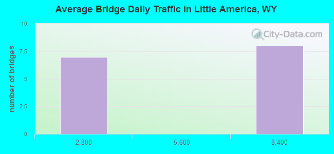
- 59,231Total average daily traffic
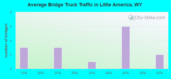
- 26,079Total average daily truck traffic
- National Bridge Inventory (NBI) Registered Bridges for Little America
- No street view available for this location
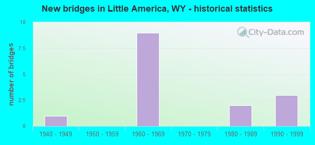
- New bridges - historical statistics
- 11940-1949
- 91960-1969
- 21980-1989
- 31990-1999
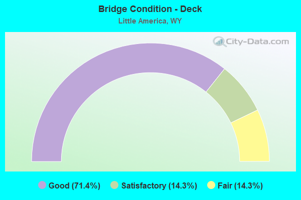
- Bridge Condition - Deck
- 71.4%Good
- 14.3%Satisfactory
- 14.3%Fair
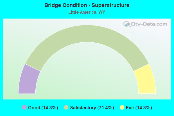
- Bridge Condition - Superstructure
- 14.3%Good
- 71.4%Satisfactory
- 14.3%Fair
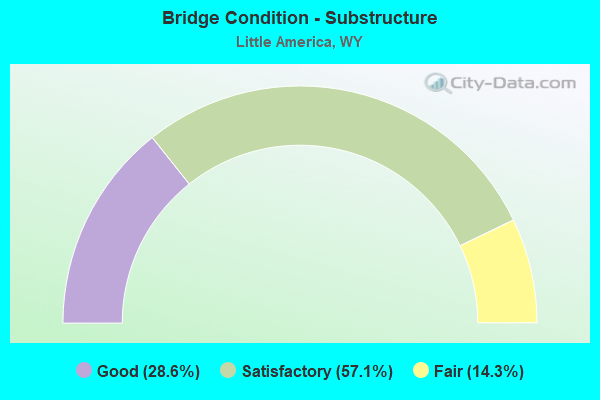
- Bridge Condition - Substructure
- 28.6%Good
- 57.1%Satisfactory
- 14.3%Fair
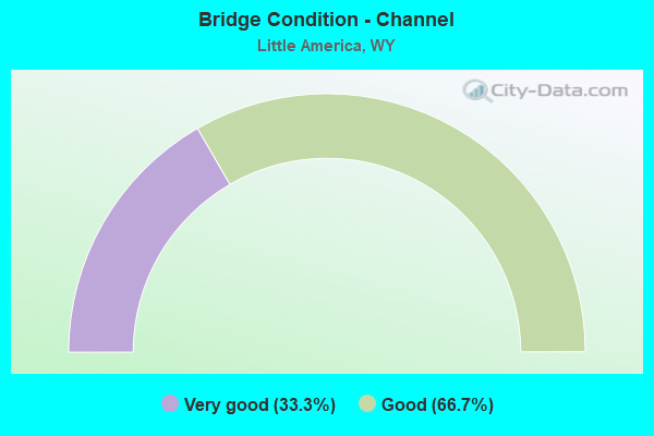
- Bridge Condition - Channel
- 33.3%Very good
- 66.7%Good
Find on map >> Show street view
Structure Number: AOL, Location: Granger Jct - Green River (Lat: 41.542111, Lng: -109.857583), Route carried "on" structure: Interstate 80, Year Built: 1967, Status: Open, Structure Length: 3.66m (12.01ft), Average Daily Traffic: 7,699 (year 2021), Truck Traffic: 50%, Average Future Daily Traffic: 10,779 (year 2041), Design Load: HS 20+Mod, Features Intersected: WYO 374
Minimum Vertical Clearance: 5.27m (17.29ft), Kilometerpoint: 111.038, Lanes on structure: 2, Lanes under structure: 2, Base Highway Network: Yes (Inventory Route: ML8, Subroute: 1), Owner: State Highway Agency, Approaching Roadway Width: 11.6m (38.1ft), Skew: 10 degrees, Material/Design: Concrete continuous, Design/Construction: Tee Beam, Number Of Spans In Main Unit: 3, Length of Maximum Span: 14.3m (46.9ft), Curb-To-Curb Width: 11.6m (38.1ft), Out-to-Out Width: 12.4m (40.7ft)
Condition: Deck: Good, Superstructure: Satisfactory, Substructure: Satisfactory, Operating Rating: 54.0 metric tons, Method Used To Determine Operating Rating: Load Factor (LF), Inventory Rating: 32.4 metric tons, Method Used To Determine Inventory Rating: Load Factor (LF), Structural Evaluation: Equal to present minimum criteria, Deck Geometry: Equal to present minimum criteria, Underclear: Somewhat better than minimum adequacy, Approach Roadway Alignment: Equal to present desirable criteria, Designated Inspection Frequency: Every 24 months, Inspection Date: Febuary 2022, Deck Structure Type: Concrete Cast-file-Place, Wearing Surface/Protective System: Wearing Surface: Epoxy Overlay
Find on map >> Show street view
Structure Number: AOM, Location: Granger Jct - Green River (Lat: 41.542542, Lng: -109.857600), Route carried "on" structure: Interstate 80, Year Built: 1967, Status: Open, Structure Length: 3.66m (12.01ft), Average Daily Traffic: 7,200 (year 2021), Truck Traffic: 44%, Average Future Daily Traffic: 10,080 (year 2041), Design Load: HS 20+Mod, Features Intersected: WYO 374
Minimum Vertical Clearance: 5.27m (17.29ft), Kilometerpoint: 110.839, Lanes on structure: 2, Lanes under structure: 2, Base Highway Network: Yes (Inventory Route: ML8, Subroute: 1), Owner: State Highway Agency, Approaching Roadway Width: 11.6m (38.1ft), Skew: 10 degrees, Material/Design: Concrete continuous, Design/Construction: Tee Beam, Number Of Spans In Main Unit: 3, Length of Maximum Span: 14.3m (46.9ft), Curb-To-Curb Width: 11.6m (38.1ft), Out-to-Out Width: 12.4m (40.7ft)
Condition: Deck: Good, Superstructure: Satisfactory, Substructure: Satisfactory, Operating Rating: 54.4 metric tons, Method Used To Determine Operating Rating: Load Factor (LF), Inventory Rating: 32.7 metric tons, Method Used To Determine Inventory Rating: Load Factor (LF), Structural Evaluation: Equal to present minimum criteria, Deck Geometry: Equal to present minimum criteria, Underclear: Equal to present minimum criteria, Approach Roadway Alignment: Equal to present desirable criteria, Designated Inspection Frequency: Every 24 months, Inspection Date: Febuary 2022, Deck Structure Type: Concrete Cast-file-Place, Wearing Surface/Protective System: Wearing Surface: Latex Concrete
Find on map >> Show street view
Structure Number: AON, Location: Granger Jct - Green River (Lat: 41.542625, Lng: -109.793503), Route carried "on" structure: Interstate 80, Year Built: 1967, Status: Open, Structure Length: 3.05m (10.01ft), Average Daily Traffic: 7,344 (year 2021), Truck Traffic: 53%, Average Future Daily Traffic: 10,282 (year 2041), Design Load: HS 20+Mod, Features Intersected: Tenneco Road
Minimum Vertical Clearance: 30+ m (98+ ft), Kilometerpoint: 116.388, Lanes on structure: 2, Lanes under structure: 2, Base Highway Network: Yes (Inventory Route: ML8, Subroute: 1), Owner: State Highway Agency, Approaching Roadway Width: 11.6m (38.1ft), Skew: 10 degrees, Material/Design: Concrete continuous, Design/Construction: Tee Beam, Number Of Spans In Main Unit: 3, Length of Maximum Span: 12.2m (40.0ft), Curb-To-Curb Width: 11.6m (38.1ft), Out-to-Out Width: 12.4m (40.7ft)
Condition: Deck: Good, Superstructure: Satisfactory, Substructure: Good, Operating Rating: 49.9 metric tons, Method Used To Determine Operating Rating: Load Factor (LF), Inventory Rating: 29.9 metric tons, Method Used To Determine Inventory Rating: Load Factor (LF), Structural Evaluation: Equal to present minimum criteria, Deck Geometry: Equal to present minimum criteria, Underclear: High priority of corrective action, Approach Roadway Alignment: Equal to present desirable criteria, Designated Inspection Frequency: Every 24 months, Inspection Date: Febuary 2022, Deck Structure Type: Concrete Cast-file-Place, Wearing Surface/Protective System: Wearing Surface: Latex Concrete
Find on map >> Show street view
Structure Number: AOO, Location: Granger Jct - Green River (Lat: 41.543058, Lng: -109.793508), Route carried "on" structure: Interstate 80, Year Built: 1967, Status: Open, Structure Length: 3.05m (10.01ft), Average Daily Traffic: 7,200 (year 2021), Truck Traffic: 44%, Average Future Daily Traffic: 10,080 (year 2041), Design Load: HS 20+Mod, Features Intersected: Tenneco Road
Minimum Vertical Clearance: 30+ m (98+ ft), Kilometerpoint: 116.188, Lanes on structure: 2, Lanes under structure: 2, Base Highway Network: Yes (Inventory Route: ML8, Subroute: 1), Owner: State Highway Agency, Approaching Roadway Width: 11.6m (38.1ft), Skew: 10 degrees, Material/Design: Concrete continuous, Design/Construction: Tee Beam, Number Of Spans In Main Unit: 3, Length of Maximum Span: 12.2m (40.0ft), Curb-To-Curb Width: 11.6m (38.1ft), Out-to-Out Width: 12.4m (40.7ft)
Condition: Deck: Good, Superstructure: Satisfactory, Substructure: Satisfactory, Operating Rating: 49.9 metric tons, Method Used To Determine Operating Rating: Load Factor (LF), Inventory Rating: 29.9 metric tons, Method Used To Determine Inventory Rating: Load Factor (LF), Structural Evaluation: Equal to present minimum criteria, Deck Geometry: Equal to present minimum criteria, Underclear: High priority of corrective action, Approach Roadway Alignment: Equal to present desirable criteria, Designated Inspection Frequency: Every 24 months, Inspection Date: Febuary 2022, Deck Structure Type: Concrete Cast-file-Place, Wearing Surface/Protective System: Wearing Surface: Latex Concrete
Find on map >> Show street view
Structure Number: BKB, Location: Jct I-80 - Green River (Lat: 41.543564, Lng: -109.807708), Route carried "on" structure: State highway 374, Year Built: 1946, Status: Open, Structure Length: 1.12m (3.67ft), Average Daily Traffic: 544 (year 2021), Truck Traffic: 10%, Average Future Daily Traffic: 762 (year 2041), Design Load: H 20, Features Intersected: Unnamed Draw
Minimum Vertical Clearance: 30+ m (98+ ft), Kilometerpoint: 116.137, Lanes on structure: 2, Owner: State Highway Agency, Approaching Roadway Width: 8.8m (28.9ft), Skew: 3 degrees, Material/Design: Concrete continuous, Design/Construction: Culvert, Number Of Spans In Main Unit: 3, Length of Maximum Span: 3.0m (9.8ft)
Condition: Channel: Very good, Culverts: Satisfactory, Operating Rating: 32.7 metric tons, Method Used To Determine Operating Rating: Field evaluation and documented engineering judgment, Inventory Rating: 32.7 metric tons, Method Used To Determine Inventory Rating: Field evaluation and documented engineering judgment, Structural Evaluation: Equal to present minimum criteria, Waterway Adequacy: Equal to present desirable criteria, Approach Roadway Alignment: Equal to present desirable criteria, Designated Inspection Frequency: Every 24 months, Inspection Date: June 2021
Find on map >> Show street view
Structure Number: CWL, Location: Kemmerer - Granger Jct (Lat: 41.544014, Lng: -109.910519), Route carried "on" structure: Ramp US 30, Year Built: 1967, Status: Open, Structure Length: 8.23m (27.00ft), Average Daily Traffic: 88 (year 2021), Truck Traffic: 30%, Average Future Daily Traffic: 123 (year 2041), Design Load: HS 20, Features Intersected: I-80, Facility Carried by Structure: I-80 EBL Off Ramp
Minimum Vertical Clearance: 30+ m (98+ ft), Kilometerpoint: 0.908, Lanes on structure: 1, Lanes under structure: 4, Base Highway Network: Yes (Inventory Route: RP6, Subroute: 5), Owner: State Highway Agency, Approaching Roadway Width: 9.8m (32.2ft), Skew: 4 degrees, Material/Design: Concrete continuous, Design/Construction: Box Beam or Girders - Single/Spread, Number Of Spans In Main Unit: 4, Length of Maximum Span: 25.3m (83.0ft), Curb-To-Curb Width: 9.8m (32.2ft), Out-to-Out Width: 10.6m (34.8ft)
Condition: Deck: Fair, Superstructure: Satisfactory, Substructure: Satisfactory, Operating Rating: 62.1 metric tons, Method Used To Determine Operating Rating: Load Factor (LF), Inventory Rating: 35.9 metric tons, Method Used To Determine Inventory Rating: Load Factor (LF), Structural Evaluation: Equal to present minimum criteria, Deck Geometry: Superior to present desirable criteria, Underclear: Equal to present minimum criteria, Approach Roadway Alignment: Equal to present desirable criteria, Designated Inspection Frequency: Every 24 months, Inspection Date: July 2021, Deck Structure Type: Concrete Cast-file-Place, Wearing Surface/Protective System: Wearing Surface: Latex Concrete
Find on map >> Show street view
Structure Number: FOY, Location: 6 Mi Se Little America (Lat: 41.502878, Lng: -109.773672), Route carried "on" structure: County highway 85, Year Built: 1980, Status: Open, Structure Length: 1.10m (3.61ft), Average Daily Traffic: 707 (year 2021), Truck Traffic: 10%, Average Future Daily Traffic: 990 (year 2041), Design Load: HS 20, Features Intersected: Unnamed Draw
Minimum Vertical Clearance: 30+ m (98+ ft), Kilometerpoint: 5.219, Lanes on structure: 2, Owner: County Highway Agency, Approaching Roadway Width: 8.5m (27.9ft), Material/Design: Concrete, Design/Construction: Culvert, Number Of Spans In Main Unit: 4, Length of Maximum Span: 2.4m (7.9ft)
Condition: Channel: Good, Culverts: Satisfactory, Operating Rating: 32.7 metric tons, Method Used To Determine Operating Rating: Field evaluation and documented engineering judgment, Inventory Rating: 32.7 metric tons, Method Used To Determine Inventory Rating: Field evaluation and documented engineering judgment, Structural Evaluation: Equal to present minimum criteria, Waterway Adequacy: Equal to present desirable criteria, Approach Roadway Alignment: Equal to present desirable criteria, Length Of Structure Improvement: 4.57m (14.99ft), Designated Inspection Frequency: Every 24 months, Inspection Date: August 2020, Bridge Improvement Cost: $2,000, Roadway Improvement Cost: $1,000, Total Project Cost: $4,000
Find on map >> Show street view
Structure Number: FOZ, Location: 4 Mi Se Of Little America (Lat: 41.521356, Lng: -109.788236), Route carried "on" structure: County highway 85, Year Built: 1980, Status: Open, Structure Length: 3.14m (10.30ft), Average Daily Traffic: 707 (year 2021), Truck Traffic: 10%, Average Future Daily Traffic: 990 (year 2041), Design Load: HS 20, Features Intersected: Meadow Springs Draw
Minimum Vertical Clearance: 30+ m (98+ ft), Kilometerpoint: 2.757, Lanes on structure: 2, Owner: County Highway Agency, Approaching Roadway Width: 8.5m (27.9ft), Material/Design: Concrete, Design/Construction: Tee Beam, Number Of Spans In Main Unit: 2, Length of Maximum Span: 14.6m (47.9ft), Curb-To-Curb Width: 7.5m (24.6ft), Out-to-Out Width: 8.5m (27.9ft)
Condition: Deck: Satisfactory, Superstructure: Fair, Substructure: Fair, Channel: Good, Operating Rating: 32.7 metric tons, Method Used To Determine Operating Rating: Field evaluation and documented engineering judgment, Inventory Rating: 32.7 metric tons, Method Used To Determine Inventory Rating: Field evaluation and documented engineering judgment, Structural Evaluation: Somewhat better than minimum adequacy, Deck Geometry: Meets minimum limits, Waterway Adequacy: Better than present minimum criteria, Approach Roadway Alignment: Equal to present desirable criteria, Designated Inspection Frequency: Every 24 months, Inspection Date: August 2020, Deck Structure Type: Concrete Cast-file-Place, Wearing Surface/Protective System: Wearing Surface: Latex Concrete
Find on map >> Show street view
Structure Number: IYG, Location: Kemmerer-Granger Jct (Lat: 41.544483, Lng: -109.911703), Route carried "on" structure: Ramp US 12, Year Built: 1992, Status: Open, Structure Length: 10.00m (32.81ft), Average Daily Traffic: 972 (year 2021), Truck Traffic: 20%, Average Future Daily Traffic: 1,361 (year 2041), Design Load: HS 20, Features Intersected: I-80, Facility Carried by Structure: I-80 EBL On Ramp
Minimum Vertical Clearance: 30.18m (99.02ft), Kilometerpoint: 0.787, Lanes on structure: 1, Lanes under structure: 4, Base Highway Network: Yes (Inventory Route: RP6, Subroute: 5), Owner: State Highway Agency, Approaching Roadway Width: 8.2m (26.9ft), Skew: 5 degrees, Material/Design: Prestressed concrete, Design/Construction: Box Beam or Girders - Multiple, Number Of Spans In Main Unit: 4, Length of Maximum Span: 31.1m (102.0ft), Curb-To-Curb Width: 7.9m (25.9ft), Out-to-Out Width: 8.7m (28.5ft)
Condition: Deck: Good, Superstructure: Good, Substructure: Good, Operating Rating: 70.8 metric tons, Method Used To Determine Operating Rating: Load Factor (LF), Inventory Rating: 42.6 metric tons, Method Used To Determine Inventory Rating: Load Factor (LF), Structural Evaluation: Better than present minimum criteria, Deck Geometry: Equal to present desirable criteria, Underclear: Equal to present minimum criteria, Approach Roadway Alignment: Equal to present desirable criteria, Designated Inspection Frequency: Every 24 months, Inspection Date: July 2021, Deck Structure Type: Concrete Cast-file-Place
Find on map >> Show street view
Structure Number: AOL, Location: Granger Jct - Green River (Lat: 41.542111, Lng: -109.857583), Route carried "under" structure: State highway 374, Year Built: 1967, Structure Length: 0. m, Average Daily Traffic: 469 (year 2021), Truck Traffic: 24%, Features Intersected: WYO 374, Facility Carried by Structure: I-80 EBL
Minimum Vertical Clearance: 5.27m (17.29ft), Kilometerpoint: 0.026, Lanes on structure: 2, Lanes under structure: 2, Material/Design: Concrete continuous, Design/Construction: Tee Beam, Length of Maximum Span: 14.3m (46.9ft)
Find on map >> Show street view
Structure Number: AOM, Location: Granger Jct - Green River (Lat: 41.542542, Lng: -109.857600), Route carried "under" structure: State highway 374, Year Built: 1967, Structure Length: 0. m, Average Daily Traffic: 469 (year 2021), Truck Traffic: 24%, Features Intersected: WYO 374, Facility Carried by Structure: I-80 WBL
Minimum Vertical Clearance: 5.23m (17.16ft), Kilometerpoint: 111.856, Lanes on structure: 2, Lanes under structure: 2, Material/Design: Concrete continuous, Design/Construction: Tee Beam, Length of Maximum Span: 14.3m (46.9ft)
Find on map >> Show street view
Structure Number: CWL, Location: Kemmerer - Granger Jct (Lat: 41.544014, Lng: -109.910519), Route carried "under" structure: Interstate 80, Year Built: 1967, Structure Length: 0. m, Average Daily Traffic: 6,593 (year 2021), Truck Traffic: 44%, Features Intersected: I-80
Minimum Vertical Clearance: 5.38m (17.65ft), Kilometerpoint: 106.387, Lanes on structure: 1, Lanes under structure: 2, Material/Design: Concrete continuous, Design/Construction: Box Beam or Girders - Single/Spread, Length of Maximum Span: 25.3m (83.0ft)
Find on map >> Show street view
Structure Number: CWL, Location: Kemmerer - Granger Jct (Lat: 41.544014, Lng: -109.910519), Route carried "under" structure: Interstate 80, Year Built: 1967, Structure Length: 0. m, Average Daily Traffic: 6,323 (year 2021), Truck Traffic: 44%, Features Intersected: I-80
Minimum Vertical Clearance: 5.24m (17.19ft), Kilometerpoint: 106.584, Lanes on structure: 1, Lanes under structure: 2, Material/Design: Concrete continuous, Design/Construction: Box Beam or Girders - Single/Spread, Length of Maximum Span: 25.3m (83.0ft)
Find on map >> Show street view
Structure Number: IYG, Location: Kemmerer-Granger Jct (Lat: 41.544483, Lng: -109.911703), Route carried "under" structure: Interstate 80, Year Built: 1992, Structure Length: 0. m, Average Daily Traffic: 6,323 (year 2021), Truck Traffic: 44%, Features Intersected: I-80
Minimum Vertical Clearance: 5.99m (19.65ft), Kilometerpoint: 106.494, Lanes on structure: 1, Lanes under structure: 2, Material/Design: Prestressed concrete, Design/Construction: Box Beam or Girders - Multiple, Length of Maximum Span: 31.1m (102.0ft)
Find on map >> Show street view
Structure Number: IYG, Location: Kemmerer-Granger Jct (Lat: 41.544483, Lng: -109.911703), Route carried "under" structure: Interstate 80, Year Built: 1992, Structure Length: 0. m, Average Daily Traffic: 6,593 (year 2021), Truck Traffic: 44%, Features Intersected: I-80
Minimum Vertical Clearance: 5.76m (18.90ft), Kilometerpoint: 106.296, Lanes on structure: 1, Lanes under structure: 2, Material/Design: Prestressed concrete, Design/Construction: Box Beam or Girders - Multiple, Length of Maximum Span: 31.1m (102.0ft)