Bridge Statistics for Londonderry, New Hampshire (NH)
Condition, Traffic, Stress, Structural Evaluation, Project Costs
- National Bridge Inventory (NBI) Statistics
- 20Number of bridges
- 167ft / 50.8mTotal length
- $43,988,000Total costs
- 444,026Total average daily traffic
- 28,979Total average daily truck traffic
- National Bridge Inventory (NBI) Registered Bridges for Londonderry
- No street view available for this location
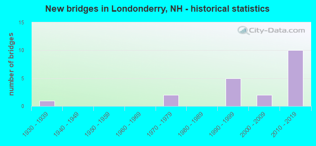
- New bridges - historical statistics
- 11930-1939
- 21970-1979
- 51990-1999
- 22000-2009
- 102010-2019
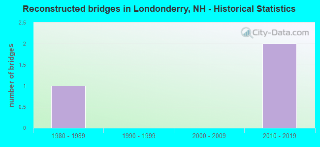
- Reconstructed bridges - Historical Statistics
- 11980-1989
- 01990-1999
- 02000-2009
- 22010-2019
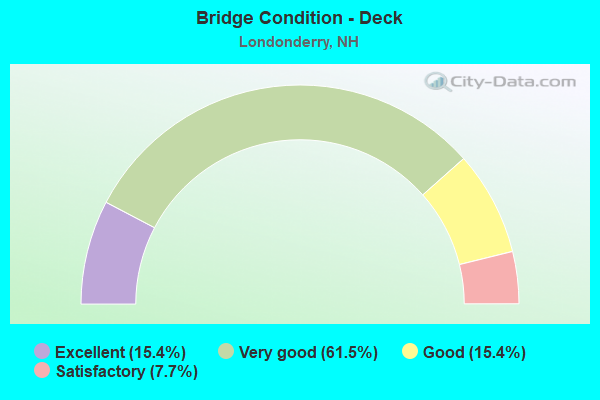
- Bridge Condition - Deck
- 15.4%Excellent
- 61.5%Very good
- 15.4%Good
- 7.7%Satisfactory
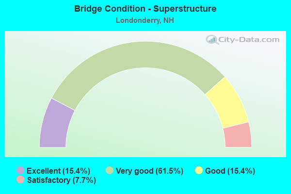
- Bridge Condition - Superstructure
- 15.4%Excellent
- 61.5%Very good
- 15.4%Good
- 7.7%Satisfactory
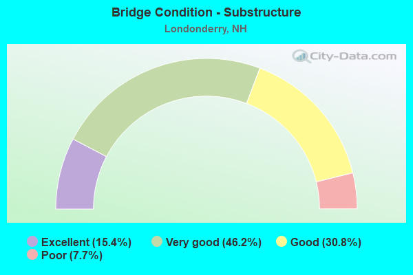
- Bridge Condition - Substructure
- 15.4%Excellent
- 46.2%Very good
- 30.8%Good
- 7.7%Poor
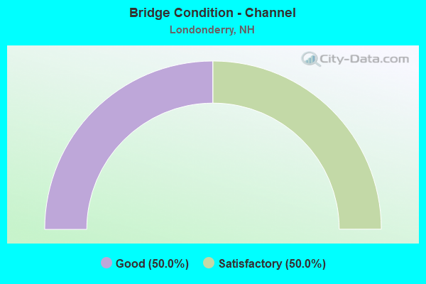
- Bridge Condition - Channel
- 50.0%Good
- 50.0%Satisfactory
Find on map >> Show street view
Structure Number: 131007800152, Location: 0.4 MI. RTE. 111 (Lat: 42.790417, Lng: -71.364425), Route carried "on" structure: Other road , Year Built: 1995, Status: Open, Structure Length: 1.04m (3.41ft), Average Daily Traffic: 1,356 (year 2020), Truck Traffic: 4%, Average Future Daily Traffic: 2,006 (year 2042), Design Load: HS 25 or greater, Features Intersected: BEAVER BROOK, Facility Carried by Structure: BRIDLE BRIDGE ROAD
Minimum Vertical Clearance: 30+ m (98+ ft), Kilometerpoint: 0.269, Lanes on structure: 2, Owner: City or Municipal Highway Agency, Approaching Roadway Width: 7.3m (24.0ft), Material/Design: Concrete, Design/Construction: Arch - Deck, Number Of Spans In Main Unit: 1, Length of Maximum Span: 9.8m (32.2ft), Curb-To-Curb Width: 8.5m (27.9ft), Out-to-Out Width: 9.4m (30.8ft)
Condition: Deck: Good, Superstructure: Good, Substructure: Good, Channel: Satisfactory, Operating Rating: 64.4 metric tons, Method Used To Determine Operating Rating: Load Factor (LF), Inventory Rating: 42.6 metric tons, Method Used To Determine Inventory Rating: Load Factor (LF), Structural Evaluation: Better than present minimum criteria, Deck Geometry: Somewhat better than minimum adequacy, Waterway Adequacy: Equal to present desirable criteria, Approach Roadway Alignment: Equal to present desirable criteria, Length Of Structure Improvement: 1.04m (3.41ft), Designated Inspection Frequency: Every 24 months, Inspection Date: September 2021, Bridge Improvement Cost: $2,718,000, Roadway Improvement Cost: $200,000, Total Project Cost: $3,142,000 ( Estimate for 2022), Deck Structure Type: Concrete Precast Panels, Wearing Surface/Protective System: Wearing Surface: Bituminous
Find on map >> Show street view
Structure Number: 154007000135, Location: 0.73 MI FR HARVEY RD (Lat: 42.906944, Lng: -71.405725), Route carried "on" structure: Other road , Year Built: 1974, Status: Open, Structure Length: 0.73m (2.40ft), Average Daily Traffic: 1,701 (year 2020), Truck Traffic: 4%, Average Future Daily Traffic: 2,517 (year 2042), Design Load: HS 20, Features Intersected: LITTLE COHAS BROOK, Facility Carried by Structure: HALL ROAD
Minimum Vertical Clearance: 30+ m (98+ ft), Kilometerpoint: 1.188, Lanes on structure: 2, Owner: City or Municipal Highway Agency, Approaching Roadway Width: 6.1m (20.0ft), Material/Design: Concrete, Design/Construction: Slab, Number Of Spans In Main Unit: 1, Length of Maximum Span: 6.4m (21.0ft), Curb or Sidewalk Widths: Left: 0.2m (0.7ft), Right: 0.2m (0.7ft), Curb-To-Curb Width: 8.5m (27.9ft), Out-to-Out Width: 9.8m (32.2ft)
Condition: Deck: Satisfactory, Superstructure: Satisfactory, Substructure: Poor, Channel: Satisfactory, Operating Rating: 45.4 metric tons, Method Used To Determine Operating Rating: Allowable Stress (AS), Inventory Rating: 32.7 metric tons, Method Used To Determine Inventory Rating: Allowable Stress (AS), Structural Evaluation: Meets minimum limits, Deck Geometry: Somewhat better than minimum adequacy, Waterway Adequacy: Equal to present desirable criteria, Approach Roadway Alignment: Equal to present desirable criteria, Length Of Structure Improvement: 0.73m (2.40ft), Designated Inspection Frequency: Every 16 months, Inspection Date: November 2021, Bridge Improvement Cost: $2,718,000, Roadway Improvement Cost: $200,000, Total Project Cost: $3,142,000 ( Estimate for 2022), Deck Structure Type: Concrete Cast-file-Place, Wearing Surface/Protective System: Wearing Surface: Bituminous, Membrane: Other
Find on map >> Show street view
Structure Number: 154009400164, Location: 1.5MI S MANCHESTER T/L (Lat: 42.919064, Lng: -71.374114), Route carried "on" structure: Ramp Other road , Year Built: 2009, Status: Open, Structure Length: 3.11m (10.20ft), Average Daily Traffic: 7,463 (year 2020), Truck Traffic: 5%, Average Future Daily Traffic: 11,045 (year 2042), Design Load: HS 25 or greater, Features Intersected: RECREATION TRAIL, Facility Carried by Structure: I-93 SB OFF RAMP
Minimum Vertical Clearance: 30+ m (98+ ft), Kilometerpoint: 0.409, Lanes on structure: 1, Base Highway Network: Yes, Owner: State Highway Agency, Approaching Roadway Width: 8.2m (26.9ft), Skew: 3 degrees, Material/Design: Prestressed concrete, Design/Construction: Stringer/Multi-beam, Number Of Spans In Main Unit: 1, Length of Maximum Span: 30.3m (99.4ft), Curb or Sidewalk Widths: Left: 0.2m (0.7ft), Right: 0.2m (0.7ft), Curb-To-Curb Width: 8.2m (26.9ft), Out-to-Out Width: 9.4m (30.8ft)
Condition: Deck: Very good, Superstructure: Very good, Substructure: Very good, Operating Rating: 89.8 metric tons, Method Used To Determine Operating Rating: Load Factor (LF), Inventory Rating: 58.8 metric tons, Method Used To Determine Inventory Rating: Load Factor (LF), Structural Evaluation: Equal to present desirable criteria, Deck Geometry: Superior to present desirable criteria, Approach Roadway Alignment: Equal to present desirable criteria, Length Of Structure Improvement: 3.11m (10.20ft), Designated Inspection Frequency: Every 24 months, Inspection Date: June 2021, Bridge Improvement Cost: $2,718,000, Roadway Improvement Cost: $200,000, Total Project Cost: $3,142,000 ( Estimate for 2022), Deck Structure Type: Concrete Cast-file-Place, Wearing Surface/Protective System: Wearing Surface: Bituminous, Membrane: Preformed Fabric, Deck Protection: Epoxy Coated Reinforcing
Find on map >> Show street view
Structure Number: 154009500164, Location: 1.5 MI S MANCHESTER LINE (Lat: 42.918983, Lng: -71.373683), Route carried "on" structure: Interstate I93, Year Built: 2013, Status: Open, Structure Length: 2.99m (9.81ft), Average Daily Traffic: 35,351 (year 2020), Truck Traffic: 9%, Average Future Daily Traffic: 52,319 (year 2042), Design Load: HS 25 or greater, Features Intersected: RECREATION TRAIL, Facility Carried by Structure: I-93 SB
Minimum Vertical Clearance: 30+ m (98+ ft), Kilometerpoint: 187.435, Lanes on structure: 4, Base Highway Network: Yes, Owner: State Highway Agency, Approaching Roadway Width: 21.6m (70.9ft), Skew: 4 degrees, Material/Design: Prestressed concrete, Design/Construction: Stringer/Multi-beam, Number Of Spans In Main Unit: 1, Length of Maximum Span: 28.0m (91.9ft), Curb or Sidewalk Widths: Left: 0.2m (0.7ft), Right: 0.2m (0.7ft), Curb-To-Curb Width: 21.6m (70.9ft), Out-to-Out Width: 22.9m (75.1ft)
Condition: Deck: Very good, Superstructure: Very good, Substructure: Very good, Operating Rating: 68.2 metric tons, Method Used To Determine Operating Rating: Load Factor (LF), Inventory Rating: 40.8 metric tons, Method Used To Determine Inventory Rating: Load Factor (LF), Structural Evaluation: Equal to present desirable criteria, Deck Geometry: Better than present minimum criteria, Approach Roadway Alignment: Equal to present desirable criteria, Length Of Structure Improvement: 2.99m (9.81ft), Designated Inspection Frequency: Every 24 months, Inspection Date: June 2021, Bridge Improvement Cost: $2,718,000, Roadway Improvement Cost: $200,000, Total Project Cost: $3,142,000 ( Estimate for 2022), Deck Structure Type: Concrete Cast-file-Place, Wearing Surface/Protective System: Wearing Surface: Bituminous, Membrane: Preformed Fabric, Deck Protection: Epoxy Coated Reinforcing
Find on map >> Show street view
Structure Number: 154009600164, Location: 1.5 M, S MANCHETER CL (Lat: 42.918772, Lng: -71.372731), Route carried "on" structure: Interstate 93, Year Built: 2014, Status: Open, Structure Length: 3.04m (9.97ft), Average Daily Traffic: 33,537 (year 2020), Truck Traffic: 9%, Average Future Daily Traffic: 49,634 (year 2042), Design Load: HS 25 or greater, Features Intersected: RECREATION TRAIL
Minimum Vertical Clearance: 30+ m (98+ ft), Kilometerpoint: 24.720, Lanes on structure: 2, Base Highway Network: Yes, Owner: State Highway Agency, Approaching Roadway Width: 21.6m (70.9ft), Skew: 4 degrees, Material/Design: Prestressed concrete, Design/Construction: Stringer/Multi-beam, Number Of Spans In Main Unit: 1, Length of Maximum Span: 27.8m (91.2ft), Curb or Sidewalk Widths: Left: 0.2m (0.7ft), Right: 0.2m (0.7ft), Curb-To-Curb Width: 21.6m (70.9ft), Out-to-Out Width: 22.9m (75.1ft)
Condition: Deck: Very good, Superstructure: Very good, Substructure: Very good, Operating Rating: 68.2 metric tons, Method Used To Determine Operating Rating: Load Factor (LF), Inventory Rating: 40.8 metric tons, Method Used To Determine Inventory Rating: Load Factor (LF), Structural Evaluation: Equal to present desirable criteria, Deck Geometry: Superior to present desirable criteria, Approach Roadway Alignment: Equal to present desirable criteria, Length Of Structure Improvement: 3.04m (9.97ft), Designated Inspection Frequency: Every 24 months, Inspection Date: June 2021, Bridge Improvement Cost: $2,718,000, Roadway Improvement Cost: $200,000, Total Project Cost: $3,142,000 ( Estimate for 2022), Deck Structure Type: Concrete Cast-file-Place, Wearing Surface/Protective System: Wearing Surface: Bituminous, Membrane: Preformed Fabric, Deck Protection: Epoxy Coated Reinforcing
Find on map >> Show street view
Structure Number: 154009800161, Location: 1.7 MI S MANCHESTER CL (Lat: 42.916581, Lng: -71.371978), Route carried "on" structure: Interstate 93, Year Built: 2013, Status: Open, Structure Length: 5.41m (17.75ft), Average Daily Traffic: 35,351 (year 2020), Truck Traffic: 9%, Average Future Daily Traffic: 52,319 (year 2042), Design Load: HS 25 or greater, Features Intersected: NH 28
Minimum Vertical Clearance: 30+ m (98+ ft), Kilometerpoint: 187.741, Lanes on structure: 2, Lanes under structure: 6, Base Highway Network: Yes, Owner: State Highway Agency, Approaching Roadway Width: 21.6m (70.9ft), Skew: 3 degrees, Material/Design: Steel, Design/Construction: Stringer/Multi-beam, Number Of Spans In Main Unit: 1, Length of Maximum Span: 52.0m (170.6ft), Curb or Sidewalk Widths: Left: 0.2m (0.7ft), Right: 0.2m (0.7ft), Curb-To-Curb Width: 21.6m (70.9ft), Out-to-Out Width: 22.9m (75.1ft)
Condition: Deck: Very good, Superstructure: Very good, Substructure: Very good, Operating Rating: 68.2 metric tons, Method Used To Determine Operating Rating: Load Factor (LF), Inventory Rating: 40.8 metric tons, Method Used To Determine Inventory Rating: Load Factor (LF), Structural Evaluation: Equal to present desirable criteria, Deck Geometry: Superior to present desirable criteria, Underclear: Somewhat better than minimum adequacy, Approach Roadway Alignment: Equal to present desirable criteria, Length Of Structure Improvement: 5.41m (17.75ft), Designated Inspection Frequency: Every 24 months, Inspection Date: June 2021, Bridge Improvement Cost: $2,718,000, Roadway Improvement Cost: $200,000, Total Project Cost: $3,142,000 ( Estimate for 2022), Deck Structure Type: Concrete Cast-file-Place, Wearing Surface/Protective System: Wearing Surface: Bituminous, Membrane: Preformed Fabric, Deck Protection: Epoxy Coated Reinforcing
Find on map >> Show street view
Structure Number: 154009800164, Location: 1.5MI S Manchester T/L (Lat: 42.918656, Lng: -71.372372), Route carried "on" structure: Ramp Other road , Year Built: 2009, Status: Open, Structure Length: 3.11m (10.20ft), Average Daily Traffic: 10,536 (year 2020), Truck Traffic: 5%, Average Future Daily Traffic: 15,593 (year 2042), Design Load: HS 25 or greater, Features Intersected: RECREATION TRAIL, Facility Carried by Structure: I-93 NB ON RAMP
Minimum Vertical Clearance: 30+ m (98+ ft), Kilometerpoint: 0.378, Lanes on structure: 2, Base Highway Network: Yes, Owner: State Highway Agency, Approaching Roadway Width: 9.1m (29.9ft), Skew: 4 degrees, Material/Design: Prestressed concrete, Design/Construction: Stringer/Multi-beam, Number Of Spans In Main Unit: 1, Length of Maximum Span: 30.2m (99.1ft), Curb or Sidewalk Widths: Left: 0.2m (0.7ft), Right: 0.2m (0.7ft), Curb-To-Curb Width: 9.4m (30.8ft), Out-to-Out Width: 10.7m (35.1ft)
Condition: Deck: Very good, Superstructure: Very good, Substructure: Very good, Operating Rating: 83.6 metric tons, Method Used To Determine Operating Rating: Load Factor (LF), Inventory Rating: 50.1 metric tons, Method Used To Determine Inventory Rating: Load Factor (LF), Structural Evaluation: Equal to present desirable criteria, Deck Geometry: Somewhat better than minimum adequacy, Approach Roadway Alignment: Equal to present desirable criteria, Length Of Structure Improvement: 3.11m (10.20ft), Designated Inspection Frequency: Every 24 months, Inspection Date: June 2021, Bridge Improvement Cost: $2,718,000, Roadway Improvement Cost: $200,000, Total Project Cost: $3,142,000 ( Estimate for 2022), Deck Structure Type: Concrete Cast-file-Place, Wearing Surface/Protective System: Wearing Surface: Bituminous, Membrane: Preformed Fabric, Deck Protection: Epoxy Coated Reinforcing
Find on map >> Show street view
Structure Number: 154009900161, Location: 1.7 MI S MANCHESTER TL (Lat: 42.916508, Lng: -71.371225), Route carried "on" structure: Interstate 93, Year Built: 2014, Status: Open, Structure Length: 5.43m (17.81ft), Average Daily Traffic: 31,724 (year 2020), Truck Traffic: 9%, Average Future Daily Traffic: 46,951 (year 2042), Design Load: HS 25 or greater, Features Intersected: NH 28
Minimum Vertical Clearance: 30+ m (98+ ft), Kilometerpoint: 24.435, Lanes on structure: 4, Lanes under structure: 6, Base Highway Network: Yes, Owner: State Highway Agency, Approaching Roadway Width: 21.6m (70.9ft), Skew: 3 degrees, Material/Design: Steel, Design/Construction: Stringer/Multi-beam, Number Of Spans In Main Unit: 1, Length of Maximum Span: 51.8m (169.9ft), Curb or Sidewalk Widths: Left: 0.2m (0.7ft), Right: 0.2m (0.7ft), Curb-To-Curb Width: 21.6m (70.9ft), Out-to-Out Width: 22.9m (75.1ft)
Condition: Deck: Very good, Superstructure: Very good, Substructure: Very good, Operating Rating: 68.2 metric tons, Method Used To Determine Operating Rating: Load Factor (LF), Inventory Rating: 40.8 metric tons, Method Used To Determine Inventory Rating: Load Factor (LF), Structural Evaluation: Equal to present desirable criteria, Deck Geometry: Better than present minimum criteria, Underclear: Somewhat better than minimum adequacy, Approach Roadway Alignment: Equal to present desirable criteria, Length Of Structure Improvement: 5.43m (17.81ft), Designated Inspection Frequency: Every 24 months, Inspection Date: June 2021, Bridge Improvement Cost: $2,718,000, Roadway Improvement Cost: $200,000, Total Project Cost: $3,142,000 ( Estimate for 2022), Deck Structure Type: Concrete Cast-file-Place, Wearing Surface/Protective System: Wearing Surface: Bituminous, Membrane: Preformed Fabric, Deck Protection: Epoxy Coated Reinforcing
Find on map >> Show street view
Structure Number: 154011300143, Location: 1.0 MI SO JCT RT 28 (Lat: 42.902742, Lng: -71.363928), Route carried "on" structure: Interstate 93, Year Built: 1996, Year Reconstructed: 2019, Status: Open, Structure Length: 2.19m (7.19ft), Average Daily Traffic: 32,630 (year 2020), Truck Traffic: 9%, Average Future Daily Traffic: 48,292 (year 2042), Design Load: HS 25 or greater, Features Intersected: STONEHENGE ROAD
Minimum Vertical Clearance: 30+ m (98+ ft), Kilometerpoint: 189.417, Lanes on structure: 2, Lanes under structure: 2, Base Highway Network: Yes, Owner: State Highway Agency, Approaching Roadway Width: 21.9m (71.9ft), Material/Design: Prestressed concrete, Design/Construction: Stringer/Multi-beam, Number Of Spans In Main Unit: 1, Length of Maximum Span: 20.4m (66.9ft), Curb or Sidewalk Widths: Left: 0.2m (0.7ft), Right: 0.2m (0.7ft), Curb-To-Curb Width: 21.6m (70.9ft), Out-to-Out Width: 22.9m (75.1ft)
Condition: Deck: Very good, Superstructure: Very good, Substructure: Good, Operating Rating: 61.3 metric tons, Method Used To Determine Operating Rating: Load and Resistance Factor (LRFR), Inventory Rating: 56.3 metric tons, Method Used To Determine Inventory Rating: Load and Resistance Factor (LRFR), Structural Evaluation: Better than present minimum criteria, Deck Geometry: Superior to present desirable criteria, Underclear: High priority of replacement, Approach Roadway Alignment: Equal to present desirable criteria, Length Of Structure Improvement: 2.19m (7.19ft), Designated Inspection Frequency: Every 24 months, Inspection Date: June 2021, Bridge Improvement Cost: $2,718,000, Roadway Improvement Cost: $200,000, Total Project Cost: $3,142,000 ( Estimate for 2022), Deck Structure Type: Concrete Cast-file-Place, Wearing Surface/Protective System: Wearing Surface: Bituminous, Membrane: Preformed Fabric, Deck Protection: Epoxy Coated Reinforcing
Find on map >> Show street view
Structure Number: 154011400144, Location: 1.0 MI S JCT RT 28 (Lat: 42.902767, Lng: -71.363375), Route carried "on" structure: Interstate 93, Year Built: 1995, Year Reconstructed: 2019, Status: Open, Structure Length: 2.24m (7.35ft), Average Daily Traffic: 31,724 (year 2020), Truck Traffic: 7%, Average Future Daily Traffic: 46,951 (year 2042), Design Load: HS 25 or greater, Features Intersected: STONEHENGE ROAD
Minimum Vertical Clearance: 30+ m (98+ ft), Kilometerpoint: 22.775, Lanes on structure: 4, Lanes under structure: 2, Base Highway Network: Yes, Owner: State Highway Agency, Approaching Roadway Width: 24.7m (81.0ft), Skew: 1 degrees, Material/Design: Prestressed concrete, Design/Construction: Stringer/Multi-beam, Number Of Spans In Main Unit: 1, Length of Maximum Span: 21.0m (68.9ft), Curb or Sidewalk Widths: Left: 0.2m (0.7ft), Right: 0.2m (0.7ft), Curb-To-Curb Width: 24.7m (81.0ft), Out-to-Out Width: 24.7m (81.0ft)
Condition: Deck: Very good, Superstructure: Very good, Substructure: Good, Operating Rating: 56.0 metric tons, Method Used To Determine Operating Rating: Load and Resistance Factor (LRFR), Inventory Rating: 42.8 metric tons, Method Used To Determine Inventory Rating: Load and Resistance Factor (LRFR), Structural Evaluation: Better than present minimum criteria, Deck Geometry: Superior to present desirable criteria, Underclear: High priority of replacement, Approach Roadway Alignment: Equal to present desirable criteria, Length Of Structure Improvement: 2.24m (7.35ft), Designated Inspection Frequency: Every 24 months, Inspection Date: June 2021, Bridge Improvement Cost: $2,718,000, Roadway Improvement Cost: $200,000, Total Project Cost: $3,142,000 ( Estimate for 2022), Deck Structure Type: Concrete Cast-file-Place, Wearing Surface/Protective System: Wearing Surface: Bituminous, Membrane: Preformed Fabric, Deck Protection: Epoxy Coated Reinforcing
Find on map >> Show street view
Structure Number: 154014000119, Location: 0.7 MI N JCT NH 102 (Lat: 42.880531, Lng: -71.344897), Route carried "on" structure: City street , Year Built: 2019, Status: Open, Structure Length: 9.56m (31.36ft), Average Daily Traffic: 6,255 (year 2020), Average Future Daily Traffic: 9,257 (year 2042), Design Load: HL 93, Features Intersected: I-93, Facility Carried by Structure: ASH STREET
Minimum Vertical Clearance: 30+ m (98+ ft), Kilometerpoint: 5.496, Lanes on structure: 2, Lanes under structure: 6, Owner: State Highway Agency, Approaching Roadway Width: 9.1m (29.9ft), Material/Design: Steel continuous, Design/Construction: Stringer/Multi-beam, Number Of Spans In Main Unit: 2, Length of Maximum Span: 46.9m (153.9ft), Curb or Sidewalk Widths: Left: 0.2m (0.7ft), Right: 1.5m (4.9ft), Curb-To-Curb Width: 9.0m (29.5ft), Out-to-Out Width: 11.6m (38.1ft)
Condition: Deck: Excellent, Superstructure: Excellent, Substructure: Excellent, Operating Rating: 58.6 metric tons, Method Used To Determine Operating Rating: Load and Resistance Factor (LRFR), Inventory Rating: 45.3 metric tons, Method Used To Determine Inventory Rating: Load and Resistance Factor (LRFR), Structural Evaluation: Superior to present desirable criteria, Deck Geometry: Meets minimum limits, Underclear: Equal to present minimum criteria, Approach Roadway Alignment: Equal to present desirable criteria, Length Of Structure Improvement: 9.56m (31.36ft), Designated Inspection Frequency: Every 24 months, Inspection Date: June 2021, Bridge Improvement Cost: $2,718,000, Roadway Improvement Cost: $200,000, Total Project Cost: $3,142,000 ( Estimate for 2022), Deck Structure Type: Concrete Cast-file-Place, Wearing Surface/Protective System: Wearing Surface: Bituminous, Membrane: Preformed Fabric, Deck Protection: Epoxy Coated Reinforcing
Find on map >> Show street view
Structure Number: 154014900106, Location: 0.7 MI N Derry T/L (Lat: 42.869833, Lng: -71.340694), Route carried "on" structure: State highway 102, Year Built: 2018, Status: Open, Structure Length: 10.32m (33.86ft), Average Daily Traffic: 29,006 (year 2020), Truck Traffic: 7%, Average Future Daily Traffic: 42,928 (year 2042), Design Load: HL 93, Features Intersected: I-93
Minimum Vertical Clearance: 30+ m (98+ ft), Kilometerpoint: 15.548, Lanes on structure: 7, Lanes under structure: 4, Base Highway Network: Yes, Owner: State Highway Agency, Approaching Roadway Width: 14.6m (47.9ft), Skew: 22 degrees, Material/Design: Steel continuous, Design/Construction: Stringer/Multi-beam, Number Of Spans In Main Unit: 2, Length of Maximum Span: 57.6m (189.0ft), Curb or Sidewalk Widths: Left: 1.5m (4.9ft), Right: 1.5m (4.9ft), Curb-To-Curb Width: 14.6m (47.9ft), Out-to-Out Width: 34.7m (113.8ft)
Condition: Deck: Excellent, Superstructure: Excellent, Substructure: Excellent, Operating Rating: 69.1 metric tons, Method Used To Determine Operating Rating: Load and Resistance Factor (LRFR), Inventory Rating: 53.3 metric tons, Method Used To Determine Inventory Rating: Load and Resistance Factor (LRFR), Structural Evaluation: Superior to present desirable criteria, Deck Geometry: High priority of replacement, Underclear: Superior to present desirable criteria, Approach Roadway Alignment: Equal to present desirable criteria, Length Of Structure Improvement: 10.32m (33.86ft), Designated Inspection Frequency: Every 24 months, Inspection Date: June 2021, Bridge Improvement Cost: $2,718,000, Roadway Improvement Cost: $200,000, Total Project Cost: $3,142,000 ( Estimate for 2022), Deck Structure Type: Concrete Cast-file-Place, Wearing Surface/Protective System: Wearing Surface: Monolithic Concrete, Deck Protection: Other Coated Reinforcing
Find on map >> Show street view
Structure Number: 154015500064, Location: 2.6 MI FR HUDSON TL (Lat: 42.839447, Lng: -71.349697), Route carried "on" structure: Other road , Year Built: 1970, Status: Open, Structure Length: 0.70m (2.30ft), Average Daily Traffic: 4,509 (year 2020), Truck Traffic: 4%, Average Future Daily Traffic: 6,673 (year 2042), Design Load: HS 20, Features Intersected: BEAVER BROOK, Facility Carried by Structure: SOUTH ROAD
Minimum Vertical Clearance: 30+ m (98+ ft), Kilometerpoint: 4.229, Lanes on structure: 2, Owner: City or Municipal Highway Agency, Approaching Roadway Width: 8.2m (26.9ft), Material/Design: Concrete, Design/Construction: Culvert, Number Of Spans In Main Unit: 1, Length of Maximum Span: 6.1m (20.0ft)
Condition: Channel: Good, Culverts: Good, Operating Rating: 45.7 metric tons, Method Used To Determine Operating Rating: Allowable Stress (AS), Inventory Rating: 32.7 metric tons, Method Used To Determine Inventory Rating: Allowable Stress (AS), Structural Evaluation: Better than present minimum criteria, Waterway Adequacy: Equal to present desirable criteria, Approach Roadway Alignment: Meets minimum limits, Length Of Structure Improvement: 0.70m (2.30ft), Designated Inspection Frequency: Every 24 months, Inspection Date: September 2021, Bridge Improvement Cost: $2,718,000, Roadway Improvement Cost: $200,000, Total Project Cost: $3,142,000 ( Estimate for 2022), Deck Structure Type: Concrete Cast-file-Place, Wearing Surface/Protective System: Wearing Surface: Bituminous
Find on map >> Show street view
Structure Number: 154016600021, Location: WINDHAM T.L. (Lat: 42.806542, Lng: -71.352983), Route carried "on" structure: State highway 128, Year Built: 1934, Year Reconstructed: 1993, Status: Open, Structure Length: 0.96m (3.15ft), Average Daily Traffic: 7,683 (year 2020), Truck Traffic: 4%, Average Future Daily Traffic: 11,370 (year 2042), Features Intersected: BEAVER BROOK
Minimum Vertical Clearance: 30+ m (98+ ft), Kilometerpoint: 12.938, Lanes on structure: 2, Owner: State Highway Agency, Approaching Roadway Width: 8.5m (27.9ft), Material/Design: Concrete, Design/Construction: Frame, Number Of Spans In Main Unit: 1, Length of Maximum Span: 8.5m (27.9ft), Curb-To-Curb Width: 9.8m (32.2ft), Out-to-Out Width: 11.0m (36.1ft)
Condition: Deck: Good, Superstructure: Good, Substructure: Good, Channel: Good, Operating Rating: 73.8 metric tons, Method Used To Determine Operating Rating: Allowable Stress (AS), Inventory Rating: 45.1 metric tons, Method Used To Determine Inventory Rating: Allowable Stress (AS), Structural Evaluation: Better than present minimum criteria, Deck Geometry: Meets minimum limits, Waterway Adequacy: Equal to present desirable criteria, Approach Roadway Alignment: Equal to present minimum criteria, Length Of Structure Improvement: 0.96m (3.15ft), Designated Inspection Frequency: Every 24 months, Inspection Date: June 2021, Bridge Improvement Cost: $2,718,000, Roadway Improvement Cost: $200,000, Total Project Cost: $3,142,000 ( Estimate for 2022), Deck Structure Type: Concrete Cast-file-Place, Wearing Surface/Protective System: Wearing Surface: Bituminous
Find on map >> Show street view
Structure Number: 154009800161, Location: 1.7 MI S MANCHESTER CL (Lat: 42.916581, Lng: -71.371978), Route carried "under" structure: State highway 28, Year Built: 2013, Structure Length: 0. m, Average Daily Traffic: 14,000 (year 2012), Truck Traffic: 8%, Features Intersected: NH 28, Facility Carried by Structure: I-93 SB
Minimum Vertical Clearance: 4.85m (15.91ft), Kilometerpoint: 26.715, Lanes on structure: 2, Lanes under structure: 6, Material/Design: Steel, Design/Construction: Stringer/Multi-beam, Length of Maximum Span: 52.0m (170.6ft)
Find on map >> Show street view
Structure Number: 154009900161, Location: 1.7 MI S MANCHESTER TL (Lat: 42.916508, Lng: -71.371225), Route carried "under" structure: State highway 28, Year Built: 2014, Structure Length: 0. m, Average Daily Traffic: 14,000 (year 2012), Features Intersected: NH 28, Facility Carried by Structure: I-93 NB
Minimum Vertical Clearance: 5.26m (17.26ft), Kilometerpoint: 0.000, Lanes on structure: 4, Lanes under structure: 6, Material/Design: Steel, Design/Construction: Stringer/Multi-beam, Length of Maximum Span: 51.8m (169.9ft)
Find on map >> Show street view
Structure Number: 154011300143, Location: 1.0 MI SO JCT RT 28 (Lat: 42.902742, Lng: -71.363928), Route carried "under" structure: City street , Year Built: 1996, Structure Length: 0. m, Average Daily Traffic: 3,600 (year 2012), Truck Traffic: 10%, Features Intersected: STONEHENGE ROAD, Facility Carried by Structure: I-93 SB
Minimum Vertical Clearance: 5.03m (16.50ft), Kilometerpoint: 0.000, Lanes on structure: 2, Lanes under structure: 2, Material/Design: Prestressed concrete, Design/Construction: Stringer/Multi-beam, Length of Maximum Span: 20.4m (66.9ft)
Find on map >> Show street view
Structure Number: 154011400144, Location: 1.0 MI S JCT RT 28 (Lat: 42.902767, Lng: -71.363375), Route carried "under" structure: City street , Year Built: 1995, Structure Length: 0. m, Average Daily Traffic: 3,600 (year 2012), Truck Traffic: 10%, Features Intersected: STONEHENGE ROAD, Facility Carried by Structure: I-93 NB
Minimum Vertical Clearance: 4.95m (16.24ft), Kilometerpoint: 0.000, Lanes on structure: 4, Lanes under structure: 2, Material/Design: Prestressed concrete, Design/Construction: Stringer/Multi-beam, Length of Maximum Span: 21.0m (68.9ft)
Find on map >> Show street view
Structure Number: 154014000119, Location: 0.7 MI N JCT NH 102 (Lat: 42.880531, Lng: -71.344897), Route carried "under" structure: Interstate 93, Year Built: 2019, Structure Length: 0. m, Average Daily Traffic: 69,000 (year 2017), Truck Traffic: 9%, Features Intersected: I-93, Facility Carried by Structure: ASH STREET
Minimum Vertical Clearance: 5.49m (18.01ft), Kilometerpoint: 0.000, Lanes on structure: 2, Lanes under structure: 6, Material/Design: Steel continuous, Design/Construction: Stringer/Multi-beam, Length of Maximum Span: 46.9m (153.9ft)
Find on map >> Show street view
Structure Number: 154014900106, Location: 0.7 MI N Derry T/L (Lat: 42.869833, Lng: -71.340694), Route carried "under" structure: Interstate 93, Year Built: 2018, Structure Length: 0. m, Average Daily Traffic: 71,000 (year 2015), Features Intersected: I-93, Facility Carried by Structure: NH102
Minimum Vertical Clearance: 4.59m (15.06ft), Kilometerpoint: 0.000, Lanes on structure: 7, Lanes under structure: 4, Material/Design: Steel continuous, Design/Construction: Stringer/Multi-beam, Length of Maximum Span: 57.6m (189.0ft)