Bridge Statistics for Loyal, Wisconsin (WI)
Condition, Traffic, Stress, Structural Evaluation, Project Costs
- National Bridge Inventory (NBI) Statistics
- 13Number of bridges
- 66ft / 20.2mTotal length
- $651,000Total costs
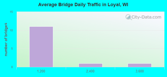
- 5,958Total average daily traffic
- 245Total average daily truck traffic
- 6,759Total future (year 2039) average daily traffic
- National Bridge Inventory (NBI) Registered Bridges for Loyal
- No street view available for this location
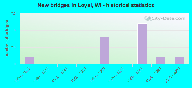
- New bridges - historical statistics
- 11920-1929
- 41960-1969
- 61980-1989
- 11990-1999
- 12000-2009
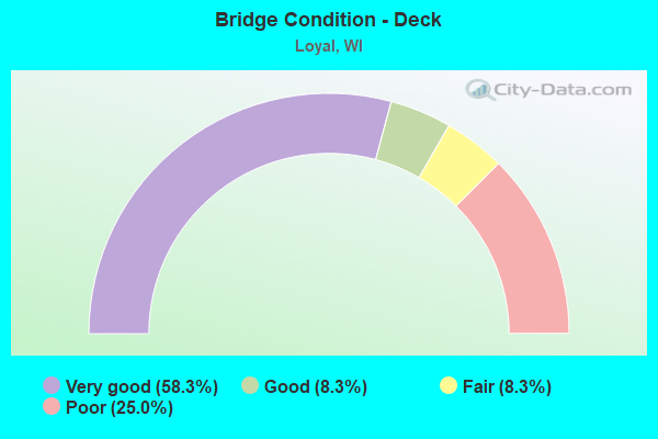
- Bridge Condition - Deck
- 58.3%Very good
- 8.3%Good
- 8.3%Fair
- 25.0%Poor
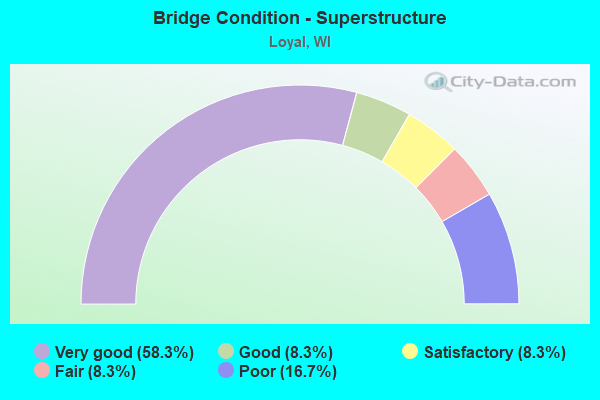
- Bridge Condition - Superstructure
- 58.3%Very good
- 8.3%Good
- 8.3%Satisfactory
- 8.3%Fair
- 16.7%Poor
- Bridge Condition - Substructure
- 41.7%Very good
- 33.3%Good
- 8.3%Fair
- 16.7%Poor
- Bridge Condition - Channel
- 84.6%Very good
- 15.4%Satisfactory
Find on map >> Show street view
Structure Number: B100053, Location: 0.5M E JCT CTH K TO S (Lat: 44.741367, Lng: -90.495472), Route carried "on" structure: State highway 98, Year Built: 1920, Year Reconstructed: 1935, Status: Open, Structure Length: 1.24m (4.07ft), Average Daily Traffic: 3,500 (year 2019), Truck Traffic: 7%, Average Future Daily Traffic: 4,060 (year 2040), Design Load: H 15, Features Intersected: BEAR CREEK
Minimum Vertical Clearance: 30+ m (98+ ft), Kilometerpoint: 0.000, Lanes on structure: 2, Owner: State Highway Agency, Approaching Roadway Width: 12.2m (40.0ft), Material/Design: Steel, Design/Construction: Stringer/Multi-beam, Number Of Spans In Main Unit: 1, Length of Maximum Span: 11.9m (39.0ft), Curb-To-Curb Width: 11.9m (39.0ft), Out-to-Out Width: 12.4m (40.7ft)
Condition: Deck: Poor, Superstructure: Satisfactory, Substructure: Fair, Channel: Satisfactory, Operating Rating: 62.1 metric tons, Method Used To Determine Operating Rating: Load Factor (LF), Inventory Rating: 37.3 metric tons, Method Used To Determine Inventory Rating: Load Factor (LF), Structural Evaluation: Somewhat better than minimum adequacy, Deck Geometry: Somewhat better than minimum adequacy, Waterway Adequacy: Equal to present desirable criteria, Approach Roadway Alignment: Equal to present desirable criteria, Length Of Structure Improvement: 1.68m (5.51ft), Designated Inspection Frequency: Every 24 months, Inspection Date: June 2021, Bridge Improvement Cost: $210,000, Roadway Improvement Cost: $21,000, Total Project Cost: $315,000 ( Estimate for 2021), Deck Structure Type: Concrete Cast-file-Place, Wearing Surface/Protective System: Wearing Surface: Monolithic Concrete, Deck Protection: Epoxy Coated Reinforcing
Find on map >> Show street view
Structure Number: B100056, Location: 0.7M W JCT CTH K (Lat: 44.791833, Lng: -90.509603), Route carried "on" structure: City street , Year Built: 1984, Status: Open, Structure Length: 1.58m (5.18ft), Average Daily Traffic: 220 (year 2019), Average Future Daily Traffic: 242 (year 2039), Design Load: H 20, Features Intersected: NELSON CREEK, Facility Carried by Structure: LRD MAPLE CENTER R
Minimum Vertical Clearance: 30+ m (98+ ft), Kilometerpoint: 0.000, Lanes on structure: 2, Owner: Town or Township Highway Agency, Approaching Roadway Width: 7.9m (25.9ft), Material/Design: Prestressed concrete, Design/Construction: Stringer/Multi-beam, Number Of Spans In Main Unit: 1, Length of Maximum Span: 15.2m (49.9ft), Curb-To-Curb Width: 7.3m (24.0ft), Out-to-Out Width: 7.9m (25.9ft)
Condition: Deck: Very good, Superstructure: Very good, Substructure: Good, Channel: Very good, Operating Rating: 44.1 metric tons, Method Used To Determine Operating Rating: Load Factor (LF), Inventory Rating: 25.9 metric tons, Method Used To Determine Inventory Rating: Load Factor (LF), Structural Evaluation: Equal to present minimum criteria, Deck Geometry: Somewhat better than minimum adequacy, Waterway Adequacy: Equal to present desirable criteria, Approach Roadway Alignment: Equal to present desirable criteria, Designated Inspection Frequency: Every 24 months, Inspection Date: September 2020, Deck Structure Type: Concrete Cast-file-Place, Wearing Surface/Protective System: Wearing Surface: Monolithic Concrete, Deck Protection: Epoxy Coated Reinforcing
Find on map >> Show street view
Structure Number: B100062, Location: 0.8M E JCT CTH K (Lat: 44.770156, Lng: -90.480864), Route carried "on" structure: City street , Year Built: 1985, Status: Open, Structure Length: 2.01m (6.59ft), Average Daily Traffic: 116 (year 2019), Average Future Daily Traffic: 127 (year 2039), Design Load: H 20, Features Intersected: ROCK CREEK, Facility Carried by Structure: LRD ROCK CREEK RD
Minimum Vertical Clearance: 30+ m (98+ ft), Kilometerpoint: 0.000, Lanes on structure: 2, Owner: Town or Township Highway Agency, Approaching Roadway Width: 9.8m (32.2ft), Skew: 2 degrees, Material/Design: Concrete, Design/Construction: Slab, Number Of Spans In Main Unit: 2, Length of Maximum Span: 9.8m (32.2ft), Curb-To-Curb Width: 7.3m (24.0ft), Out-to-Out Width: 7.9m (25.9ft)
Condition: Deck: Very good, Superstructure: Very good, Substructure: Good, Channel: Very good, Operating Rating: 47.4 metric tons, Method Used To Determine Operating Rating: Load Factor (LF), Inventory Rating: 27.5 metric tons, Method Used To Determine Inventory Rating: Load Factor (LF), Structural Evaluation: Equal to present minimum criteria, Deck Geometry: Somewhat better than minimum adequacy, Waterway Adequacy: Equal to present desirable criteria, Approach Roadway Alignment: Equal to present desirable criteria, Designated Inspection Frequency: Every 24 months, Inspection Date: September 2020, Deck Structure Type: Concrete Cast-file-Place, Wearing Surface/Protective System: Wearing Surface: Monolithic Concrete, Deck Protection: Epoxy Coated Reinforcing
Find on map >> Show street view
Structure Number: B100077, Location: 2.9M N JCT STH 98 TO E (Lat: 44.784100, Lng: -90.495908), Route carried "on" structure: County highway , Year Built: 1990, Status: Open, Structure Length: 2.37m (7.78ft), Average Daily Traffic: 1,220 (year 2019), Average Future Daily Traffic: 1,342 (year 2039), Design Load: HS 20, Features Intersected: ROCK CREEK, Facility Carried by Structure: CTH K
Minimum Vertical Clearance: 30+ m (98+ ft), Kilometerpoint: 0.000, Lanes on structure: 2, Owner: County Highway Agency, Approaching Roadway Width: 11.0m (36.1ft), Material/Design: Prestressed concrete, Design/Construction: Stringer/Multi-beam, Number Of Spans In Main Unit: 1, Length of Maximum Span: 23.2m (76.1ft), Curb-To-Curb Width: 9.1m (29.9ft), Out-to-Out Width: 9.8m (32.2ft)
Condition: Deck: Very good, Superstructure: Very good, Substructure: Very good, Channel: Very good, Operating Rating: 67.0 metric tons, Method Used To Determine Operating Rating: Load Factor (LF), Inventory Rating: 37.3 metric tons, Method Used To Determine Inventory Rating: Load Factor (LF), Structural Evaluation: Equal to present desirable criteria, Deck Geometry: Somewhat better than minimum adequacy, Waterway Adequacy: Equal to present desirable criteria, Approach Roadway Alignment: Equal to present desirable criteria, Designated Inspection Frequency: Every 48 months, Inspection Date: June 2020, Deck Structure Type: Concrete Cast-file-Place, Wearing Surface/Protective System: Wearing Surface: Monolithic Concrete, Deck Protection: Epoxy Coated Reinforcing
Find on map >> Show street view
Structure Number: B10008, Location: 3.4M W JCT CTH G (Lat: 44.625211, Lng: -90.717675), Route carried "on" structure: City street , Year Built: 1987, Status: Open, Structure Length: 2.32m (7.61ft), Average Daily Traffic: 34 (year 2019), Average Future Daily Traffic: 37 (year 2039), Design Load: H 20, Features Intersected: WEDGES CREEK, Facility Carried by Structure: LRD CHILL ROAD
Minimum Vertical Clearance: 30+ m (98+ ft), Kilometerpoint: 0.000, Lanes on structure: 2, Owner: Town or Township Highway Agency, Approaching Roadway Width: 7.3m (24.0ft), Skew: 1 degrees, Material/Design: Concrete continuous, Design/Construction: Slab, Number Of Spans In Main Unit: 2, Length of Maximum Span: 11.3m (37.1ft), Curb-To-Curb Width: 7.3m (24.0ft), Out-to-Out Width: 7.9m (25.9ft)
Condition: Deck: Good, Superstructure: Good, Substructure: Very good, Channel: Very good, Operating Rating: 57.0 metric tons, Method Used To Determine Operating Rating: Load Factor (LF), Inventory Rating: 34.0 metric tons, Method Used To Determine Inventory Rating: Load Factor (LF), Structural Evaluation: Better than present minimum criteria, Deck Geometry: Equal to present minimum criteria, Waterway Adequacy: Equal to present desirable criteria, Approach Roadway Alignment: Equal to present desirable criteria, Designated Inspection Frequency: Every 48 months, Inspection Date: August 2020, Deck Structure Type: Concrete Cast-file-Place, Wearing Surface/Protective System: Wearing Surface: Monolithic Concrete, Deck Protection: Epoxy Coated Reinforcing
Find on map >> Show street view
Structure Number: B100089, Location: 0.1M E JCT STH 98 (Lat: 44.735244, Lng: -90.491647), Route carried "on" structure: City street , Year Built: 1988, Status: Open, Structure Length: 1.07m (3.51ft), Average Daily Traffic: 454 (year 2019), Average Future Daily Traffic: 499 (year 2039), Design Load: HS 20, Features Intersected: BEAR CREEK, Facility Carried by Structure: LRD SPRING ST
Minimum Vertical Clearance: 30+ m (98+ ft), Kilometerpoint: 0.000, Lanes on structure: 2, Owner: City or Municipal Highway Agency, Approaching Roadway Width: 8.5m (27.9ft), Material/Design: Concrete, Design/Construction: Slab, Number Of Spans In Main Unit: 1, Length of Maximum Span: 10.1m (33.1ft), Curb or Sidewalk Widths: Left: 2.0m (6.6ft), Right: 0.0m, Curb-To-Curb Width: 8.5m (27.9ft), Out-to-Out Width: 10.7m (35.1ft)
Condition: Deck: Very good, Superstructure: Very good, Substructure: Very good, Channel: Very good, Operating Rating: 52.3 metric tons, Method Used To Determine Operating Rating: Load Factor (LF), Inventory Rating: 30.8 metric tons, Method Used To Determine Inventory Rating: Load Factor (LF), Structural Evaluation: Better than present minimum criteria, Deck Geometry: Somewhat better than minimum adequacy, Waterway Adequacy: Equal to present desirable criteria, Approach Roadway Alignment: Equal to present desirable criteria, Designated Inspection Frequency: Every 24 months, Inspection Date: September 2020, Deck Structure Type: Concrete Cast-file-Place, Wearing Surface/Protective System: Wearing Surface: Monolithic Concrete, Deck Protection: Epoxy Coated Reinforcing
Find on map >> Show street view
Structure Number: B100103, Location: 1.5M W JCT CTH K (Lat: 44.755875, Lng: -90.524822), Route carried "on" structure: City street , Year Built: 1989, Status: Open, Structure Length: 1.34m (4.40ft), Average Daily Traffic: 50 (year 2019), Average Future Daily Traffic: 55 (year 2039), Design Load: HS 20, Features Intersected: BEAR CREEK, Facility Carried by Structure: LRD SPENCER RD
Minimum Vertical Clearance: 30+ m (98+ ft), Kilometerpoint: 0.000, Lanes on structure: 2, Owner: Town or Township Highway Agency, Approaching Roadway Width: 7.3m (24.0ft), Skew: 1 degrees, Material/Design: Concrete, Design/Construction: Slab, Number Of Spans In Main Unit: 1, Length of Maximum Span: 12.8m (42.0ft), Curb-To-Curb Width: 7.3m (24.0ft), Out-to-Out Width: 7.9m (25.9ft)
Condition: Deck: Very good, Superstructure: Very good, Substructure: Very good, Channel: Very good, Operating Rating: 55.5 metric tons, Method Used To Determine Operating Rating: Load Factor (LF), Inventory Rating: 32.4 metric tons, Method Used To Determine Inventory Rating: Load Factor (LF), Structural Evaluation: Equal to present desirable criteria, Deck Geometry: Equal to present minimum criteria, Waterway Adequacy: Equal to present desirable criteria, Approach Roadway Alignment: Equal to present desirable criteria, Designated Inspection Frequency: Every 48 months, Inspection Date: August 2020, Deck Structure Type: Concrete Cast-file-Place, Wearing Surface/Protective System: Wearing Surface: Monolithic Concrete, Deck Protection: Epoxy Coated Reinforcing
Find on map >> Show street view
Structure Number: B100104, Location: 0.5M N JCT STH 98 (Lat: 44.748681, Lng: -90.455256), Route carried "on" structure: City street , Year Built: 1989, Status: Open, Structure Length: 1.58m (5.18ft), Average Daily Traffic: 28 (year 2019), Average Future Daily Traffic: 30 (year 2039), Design Load: HS 20, Features Intersected: ROCK CREEK, Facility Carried by Structure: LRD ROMADKA AVE
Minimum Vertical Clearance: 30+ m (98+ ft), Kilometerpoint: 0.000, Lanes on structure: 2, Owner: Town or Township Highway Agency, Approaching Roadway Width: 7.3m (24.0ft), Skew: 2 degrees, Material/Design: Concrete continuous, Design/Construction: Slab, Number Of Spans In Main Unit: 2, Length of Maximum Span: 7.6m (24.9ft), Curb-To-Curb Width: 7.3m (24.0ft), Out-to-Out Width: 7.9m (25.9ft)
Condition: Deck: Very good, Superstructure: Very good, Substructure: Good, Channel: Very good, Operating Rating: 62.1 metric tons, Method Used To Determine Operating Rating: Load Factor (LF), Inventory Rating: 37.3 metric tons, Method Used To Determine Inventory Rating: Load Factor (LF), Structural Evaluation: Better than present minimum criteria, Deck Geometry: Equal to present minimum criteria, Waterway Adequacy: Equal to present desirable criteria, Approach Roadway Alignment: Equal to present desirable criteria, Designated Inspection Frequency: Every 48 months, Inspection Date: August 2020, Deck Structure Type: Concrete Cast-file-Place, Wearing Surface/Protective System: Wearing Surface: Monolithic Concrete, Deck Protection: Epoxy Coated Reinforcing
Find on map >> Show street view
Structure Number: B100184, Location: 1.1M W JCT CTH K (Lat: 44.788086, Lng: -90.513986), Route carried "on" structure: City street , Year Built: 2000, Status: Open, Structure Length: 3.19m (10.47ft), Average Daily Traffic: 118 (year 2019), Average Future Daily Traffic: 129 (year 2039), Design Load: HS 20, Features Intersected: ROCK CREEK, Facility Carried by Structure: LRD PARK LANE AVE
Minimum Vertical Clearance: 30+ m (98+ ft), Kilometerpoint: 0.000, Lanes on structure: 2, Owner: Town or Township Highway Agency, Approaching Roadway Width: 7.9m (25.9ft), Material/Design: Prestressed concrete, Design/Construction: Stringer/Multi-beam, Number Of Spans In Main Unit: 1, Length of Maximum Span: 31.1m (102.0ft), Curb-To-Curb Width: 7.3m (24.0ft), Out-to-Out Width: 7.9m (25.9ft)
Condition: Deck: Very good, Superstructure: Very good, Substructure: Very good, Channel: Very good, Operating Rating: 88.2 metric tons, Method Used To Determine Operating Rating: Load Factor (LF), Inventory Rating: 37.3 metric tons, Method Used To Determine Inventory Rating: Load Factor (LF), Structural Evaluation: Equal to present desirable criteria, Deck Geometry: Somewhat better than minimum adequacy, Waterway Adequacy: Equal to present desirable criteria, Approach Roadway Alignment: Equal to present desirable criteria, Designated Inspection Frequency: Every 48 months, Inspection Date: September 2020, Deck Structure Type: Concrete Cast-file-Place, Wearing Surface/Protective System: Wearing Surface: Monolithic Concrete, Deck Protection: Epoxy Coated Reinforcing
Find on map >> Show street view
Structure Number: P100156, Location: 1.4M E JCT CTH K (Lat: 44.755806, Lng: -90.465917), Route carried "on" structure: City street , Year Built: 1960, Status: Posted for load, Structure Length: 1.22m (4.00ft), Average Daily Traffic: 34 (year 2019), Average Future Daily Traffic: 37 (year 2040), Design Load: H 20, Features Intersected: ROCK CREEK, Facility Carried by Structure: LRD SPENCER RD
Minimum Vertical Clearance: 30+ m (98+ ft), Kilometerpoint: 0.000, Lanes on structure: 2, Owner: Town or Township Highway Agency, Approaching Roadway Width: 6.7m (22.0ft), Material/Design: Wood or Timber, Design/Construction: Slab, Number Of Spans In Main Unit: 2, Length of Maximum Span: 5.9m (19.4ft), Curb-To-Curb Width: 6.3m (20.7ft), Out-to-Out Width: 6.7m (22.0ft)
Condition: Deck: Poor, Superstructure: Poor, Substructure: Poor, Channel: Very good, Operating Rating: 8.0 metric tons, Method Used To Determine Operating Rating: Field evaluation and documented engineering judgment, Inventory Rating: 4.9 metric tons, Method Used To Determine Inventory Rating: Field evaluation and documented engineering judgment, Structural Evaluation: High priority of replacement, Deck Geometry: Somewhat better than minimum adequacy, Waterway Adequacy: Equal to present desirable criteria, Approach Roadway Alignment: Equal to present desirable criteria, Bridge Posting: Required (Relationship of Operating Rating to Maximum Legal Load: 30.0 - 39.9% below), Length Of Structure Improvement: 1.68m (5.51ft), Designated Inspection Frequency: Every 12 months, Inspection Date: August 2021, Bridge Improvement Cost: $128,000, Roadway Improvement Cost: $12,000, Total Project Cost: $193,000 ( Estimate for 2021), Deck Structure Type: Wood or Timber, Wearing Surface/Protective System: Wearing Surface: Bituminous
Find on map >> Show street view
Structure Number: P100927, Location: 1.4M N JCT CTH K (Lat: 44.760833, Lng: -90.516306), Route carried "on" structure: City street , Year Built: 1961, Status: Open, Structure Length: 0.73m (2.40ft), Average Daily Traffic: 34 (year 2019), Average Future Daily Traffic: 37 (year 2039), Features Intersected: BR BEAR CREEK, Facility Carried by Structure: LRD MILLER AVE
Minimum Vertical Clearance: 30+ m (98+ ft), Kilometerpoint: 0.000, Lanes on structure: 2, Owner: Town or Township Highway Agency, Approaching Roadway Width: 5.5m (18.0ft), Material/Design: Wood or Timber, Design/Construction: Slab, Number Of Spans In Main Unit: 1, Length of Maximum Span: 7.0m (23.0ft), Curb-To-Curb Width: 6.0m (19.7ft), Out-to-Out Width: 6.4m (21.0ft)
Condition: Deck: Fair, Superstructure: Fair, Substructure: Good, Channel: Satisfactory, Operating Rating: 42.5 metric tons, Method Used To Determine Operating Rating: Load Factor (LF), Inventory Rating: 29.2 metric tons, Method Used To Determine Inventory Rating: Load Factor (LF), Structural Evaluation: Somewhat better than minimum adequacy, Deck Geometry: Meets minimum limits, Waterway Adequacy: Equal to present desirable criteria, Approach Roadway Alignment: Equal to present desirable criteria, Designated Inspection Frequency: Every 24 months, Inspection Date: August 2020, Deck Structure Type: Wood or Timber, Wearing Surface/Protective System: Wearing Surface: Bituminous
Find on map >> Show street view
Structure Number: P100938, Location: 0.4M E JCT CTH K (Lat: 44.698000, Lng: -90.497139), Route carried "on" structure: City street , Year Built: 1967, Status: Posted for load, Structure Length: 0.79m (2.59ft), Average Daily Traffic: 58 (year 2019), Average Future Daily Traffic: 63 (year 2040), Design Load: H 15, Features Intersected: N BR ONEILL CREEK, Facility Carried by Structure: LRD MANN RD
Minimum Vertical Clearance: 30+ m (98+ ft), Kilometerpoint: 0.000, Lanes on structure: 2, Owner: Town or Township Highway Agency, Approaching Roadway Width: 7.9m (25.9ft), Material/Design: Wood or Timber, Design/Construction: Slab, Number Of Spans In Main Unit: 1, Length of Maximum Span: 7.6m (24.9ft), Curb-To-Curb Width: 6.3m (20.7ft), Out-to-Out Width: 6.6m (21.7ft)
Condition: Deck: Poor, Superstructure: Poor, Substructure: Poor, Channel: Very good, Operating Rating: 8.0 metric tons, Method Used To Determine Operating Rating: Field evaluation and documented engineering judgment, Inventory Rating: 4.9 metric tons, Method Used To Determine Inventory Rating: Field evaluation and documented engineering judgment, Structural Evaluation: High priority of replacement, Deck Geometry: Somewhat better than minimum adequacy, Waterway Adequacy: Equal to present desirable criteria, Approach Roadway Alignment: Equal to present desirable criteria, Bridge Posting: Required (Relationship of Operating Rating to Maximum Legal Load: 30.0 - 39.9% below), Length Of Structure Improvement: 1.25m (4.10ft), Designated Inspection Frequency: Every 12 months, Inspection Date: August 2021, Bridge Improvement Cost: $95,000, Roadway Improvement Cost: $9,000, Total Project Cost: $143,000 ( Estimate for 2021), Deck Structure Type: Wood or Timber, Wearing Surface/Protective System: Wearing Surface: Wood or Timber
Find on map >> Show street view
Structure Number: P100948, Location: 1.8M E JCT CTH K (Lat: 44.770222, Lng: -90.458653), Route carried "on" structure: City street , Year Built: 1969, Status: Open, Structure Length: 0.73m (2.40ft), Average Daily Traffic: 92 (year 2019), Average Future Daily Traffic: 101 (year 2039), Design Load: H 15, Features Intersected: BR ROCK CREEK, Facility Carried by Structure: LRD ROCK CREEK RD
Minimum Vertical Clearance: 30+ m (98+ ft), Kilometerpoint: 0.000, Lanes on structure: 2, Owner: Town or Township Highway Agency, Approaching Roadway Width: 6.1m (20.0ft), Material/Design: Concrete, Design/Construction: Culvert, Number Of Spans In Main Unit: 4, Length of Maximum Span: 1.9m (6.2ft)
Condition: Channel: Very good, Culverts: Fair, Operating Rating: 53.9 metric tons, Method Used To Determine Operating Rating: Field evaluation and documented engineering judgment, Inventory Rating: 24.3 metric tons, Method Used To Determine Inventory Rating: Field evaluation and documented engineering judgment, Structural Evaluation: Somewhat better than minimum adequacy, Waterway Adequacy: Equal to present desirable criteria, Approach Roadway Alignment: Equal to present desirable criteria, Designated Inspection Frequency: Every 24 months, Inspection Date: September 2020, Deck Structure Type: Concrete Cast-file-Place, Wearing Surface/Protective System: Wearing Surface: Monolithic Concrete