Bridge Statistics for Lupton, Arizona (AZ)
Condition, Traffic, Stress, Structural Evaluation, Project Costs
- National Bridge Inventory (NBI) Statistics
- 11Number of bridges
- 20ft / 6.0mTotal length
- $1,000Total costs
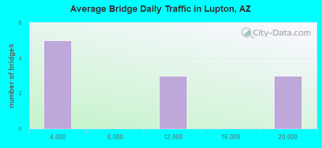
- 90,482Total average daily traffic
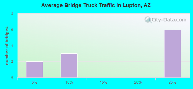
- 21,025Total average daily truck traffic
- National Bridge Inventory (NBI) Registered Bridges for Lupton
- No street view available for this location
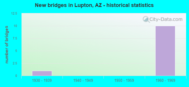
- New bridges - historical statistics
- 11930-1939
- 101960-1969
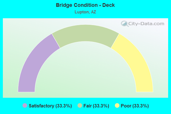
- Bridge Condition - Deck
- 33.3%Satisfactory
- 33.3%Fair
- 33.3%Poor
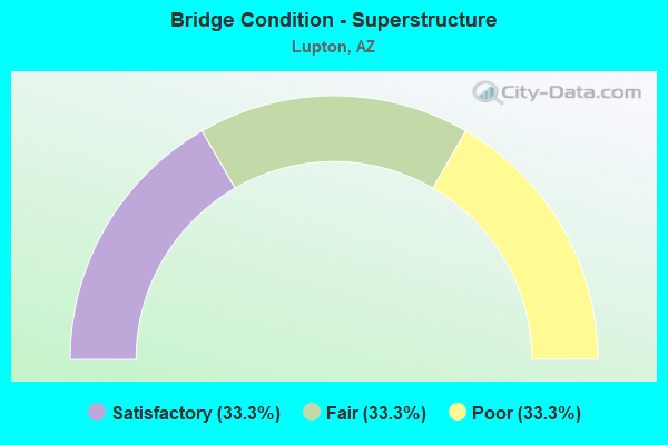
- Bridge Condition - Superstructure
- 33.3%Satisfactory
- 33.3%Fair
- 33.3%Poor
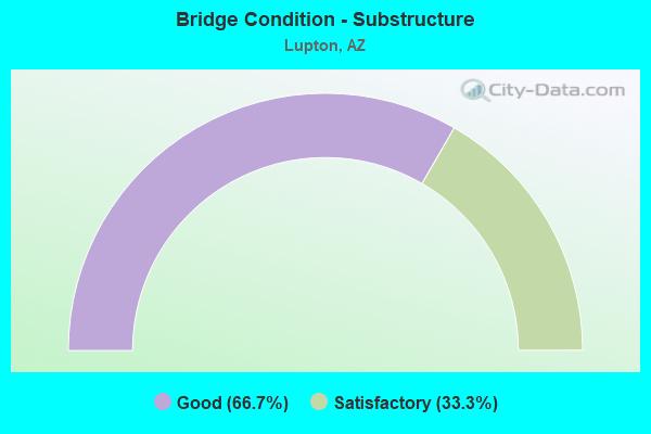
- Bridge Condition - Substructure
- 66.7%Good
- 33.3%Satisfactory
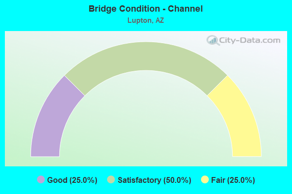
- Bridge Condition - Channel
- 25.0%Good
- 50.0%Satisfactory
- 25.0%Fair
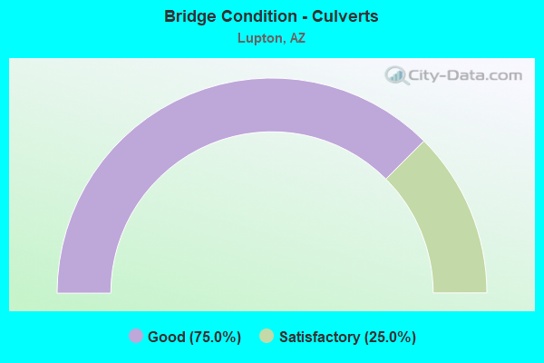
- Bridge Condition - Culverts
- 75.0%Good
- 25.0%Satisfactory
Find on map >> Show street view
Structure Number: 677, Location: 18.0 mi E Jct US 191 (Lat: 35.337850, Lng: -109.068147), Route carried "on" structure: Interstate 40, Year Built: 1963, Status: Open, Structure Length: 1.04m (3.41ft), Average Daily Traffic: 10,067 (year 2017), Truck Traffic: 24%, Average Future Daily Traffic: 10,077 (year 2038), Design Load: HS 20, Features Intersected: Window Rock Road
Minimum Vertical Clearance: 30+ m (98+ ft), Kilometerpoint: 575.389, Lanes on structure: 2, Lanes under structure: 2, Owner: State Highway Agency, Approaching Roadway Width: 11.6m (38.1ft), Material/Design: Concrete, Design/Construction: Frame, Number Of Spans In Main Unit: 1, Length of Maximum Span: 9.1m (29.9ft), Curb-To-Curb Width: 11.3m (37.1ft), Out-to-Out Width: 12.2m (40.0ft)
Condition: Deck: Satisfactory, Superstructure: Satisfactory, Substructure: Good, Operating Rating: 51.7 metric tons, Method Used To Determine Operating Rating: Load Factor (LF), Inventory Rating: 30.8 metric tons, Method Used To Determine Inventory Rating: Load Factor (LF), Structural Evaluation: Equal to present minimum criteria, Deck Geometry: Somewhat better than minimum adequacy, Underclear: Meets minimum limits, Approach Roadway Alignment: Equal to present desirable criteria, Designated Inspection Frequency: Every 24 months, Inspection Date: July 2020, Deck Structure Type: Concrete Cast-file-Place, Wearing Surface/Protective System: Wearing Surface: Bituminous
Find on map >> Show street view
Structure Number: 678, Location: 18.0 mi E Jct US 191 (Lat: 35.338053, Lng: -109.068439), Route carried "on" structure: Interstate 40, Year Built: 1964, Status: Open, Structure Length: 1.04m (3.41ft), Average Daily Traffic: 9,700 (year 2017), Truck Traffic: 24%, Average Future Daily Traffic: 9,710 (year 2038), Design Load: HS 20, Features Intersected: Window Rock Rd
Minimum Vertical Clearance: 30+ m (98+ ft), Kilometerpoint: 575.389, Lanes on structure: 2, Lanes under structure: 2, Owner: State Highway Agency, Approaching Roadway Width: 11.6m (38.1ft), Material/Design: Concrete, Design/Construction: Frame, Number Of Spans In Main Unit: 1, Length of Maximum Span: 9.1m (29.9ft), Curb-To-Curb Width: 11.3m (37.1ft), Out-to-Out Width: 12.2m (40.0ft)
Condition: Deck: Poor, Superstructure: Poor, Substructure: Good, Operating Rating: 51.7 metric tons, Method Used To Determine Operating Rating: Load Factor (LF), Inventory Rating: 30.8 metric tons, Method Used To Determine Inventory Rating: Load Factor (LF), Structural Evaluation: Meets minimum limits, Deck Geometry: Somewhat better than minimum adequacy, Underclear: Meets minimum limits, Approach Roadway Alignment: Equal to present desirable criteria, Length Of Structure Improvement: 1.80m (5.91ft), Designated Inspection Frequency: Every 24 months, Inspection Date: July 2020, Total Project Cost: $1,000 ( Estimate for 2018), Deck Structure Type: Concrete Cast-file-Place, Wearing Surface/Protective System: Wearing Surface: Bituminous
Find on map >> Show street view
Structure Number: 68, Location: 19.8 mi E Jct US 191 (Lat: 35.357875, Lng: -109.051917), Route carried "on" structure: Interstate 40, Year Built: 1963, Status: Open, Structure Length: 1.04m (3.41ft), Average Daily Traffic: 8,877 (year 2017), Truck Traffic: 24%, Average Future Daily Traffic: 8,887 (year 2038), Design Load: HS 20, Features Intersected: Lupton Rd
Minimum Vertical Clearance: 30+ m (98+ ft), Kilometerpoint: 578.092, Lanes on structure: 2, Lanes under structure: 2, Owner: State Highway Agency, Approaching Roadway Width: 11.6m (38.1ft), Material/Design: Concrete, Design/Construction: Frame, Number Of Spans In Main Unit: 1, Length of Maximum Span: 9.1m (29.9ft), Curb-To-Curb Width: 11.3m (37.1ft), Out-to-Out Width: 12.2m (40.0ft)
Condition: Deck: Fair, Superstructure: Fair, Substructure: Satisfactory, Operating Rating: 51.7 metric tons, Method Used To Determine Operating Rating: Load Factor (LF), Inventory Rating: 30.8 metric tons, Method Used To Determine Inventory Rating: Load Factor (LF), Structural Evaluation: Somewhat better than minimum adequacy, Deck Geometry: Somewhat better than minimum adequacy, Underclear: Meets minimum limits, Approach Roadway Alignment: Equal to present desirable criteria, Designated Inspection Frequency: Every 24 months, Inspection Date: July 2020, Deck Structure Type: Concrete Cast-file-Place, Wearing Surface/Protective System: Wearing Surface: Bituminous
Find on map >> Show street view
Structure Number: 6006, Location: 15.6 mi East Jct US 191 (Lat: 35.319600, Lng: -109.089700), Route carried "on" structure: Interstate 40, Year Built: 1963, Status: Open, Structure Length: 0.98m (3.22ft), Average Daily Traffic: 19,336 (year 2017), Truck Traffic: 24%, Average Future Daily Traffic: 19,346 (year 2038), Design Load: HS 20, Features Intersected: Wash
Minimum Vertical Clearance: 30+ m (98+ ft), Kilometerpoint: 571.784, Lanes on structure: 6, Owner: State Highway Agency, Approaching Roadway Width: 23.2m (76.1ft), Skew: 34 degrees, Material/Design: Concrete continuous, Design/Construction: Culvert, Number Of Spans In Main Unit: 2, Length of Maximum Span: 3.0m (9.8ft)
Condition: Channel: Fair, Culverts: Satisfactory, Operating Rating: 89.8 metric tons, Method Used To Determine Operating Rating: Load Factor (LF), Inventory Rating: 89.8 metric tons, Method Used To Determine Inventory Rating: Load Factor (LF), Structural Evaluation: Equal to present minimum criteria, Waterway Adequacy: Equal to present desirable criteria, Approach Roadway Alignment: Equal to present desirable criteria, Designated Inspection Frequency: Every 48 months, Inspection Date: July 2018
Find on map >> Show street view
Structure Number: 6008, Location: 17.8 mi East Jct US 191 (Lat: 35.344700, Lng: -109.062200), Route carried "on" structure: Interstate 40, Year Built: 1963, Year Reconstructed: 1975, Status: Open, Structure Length: 0.64m (2.10ft), Average Daily Traffic: 19,336 (year 2017), Truck Traffic: 24%, Average Future Daily Traffic: 19,336 (year 2038), Design Load: HS 20, Features Intersected: Wash
Minimum Vertical Clearance: 30+ m (98+ ft), Kilometerpoint: 575.308, Lanes on structure: 5, Owner: State Highway Agency, Approaching Roadway Width: 21.9m (71.9ft), Skew: 30 degrees, Material/Design: Concrete continuous, Design/Construction: Culvert, Number Of Spans In Main Unit: 2, Length of Maximum Span: 3.0m (9.8ft)
Condition: Channel: Good, Culverts: Good, Operating Rating: 89.8 metric tons, Method Used To Determine Operating Rating: Load Factor (LF), Inventory Rating: 89.8 metric tons, Method Used To Determine Inventory Rating: Load Factor (LF), Structural Evaluation: Better than present minimum criteria, Waterway Adequacy: Equal to present desirable criteria, Approach Roadway Alignment: Equal to present desirable criteria, Designated Inspection Frequency: Every 48 months, Inspection Date: July 2018
Find on map >> Show street view
Structure Number: 601, Location: 19.3 mi East Jct US 191 (Lat: 35.353900, Lng: -109.055900), Route carried "on" structure: Interstate 40, Year Built: 1963, Status: Open, Structure Length: 0.64m (2.10ft), Average Daily Traffic: 19,766 (year 2017), Truck Traffic: 24%, Average Future Daily Traffic: 19,776 (year 2038), Design Load: HS 20, Features Intersected: Wash
Minimum Vertical Clearance: 30+ m (98+ ft), Kilometerpoint: 577.738, Lanes on structure: 7, Owner: State Highway Agency, Approaching Roadway Width: 11.6m (38.1ft), Skew: 29 degrees, Material/Design: Concrete continuous, Design/Construction: Culvert, Number Of Spans In Main Unit: 2, Length of Maximum Span: 3.0m (9.8ft)
Condition: Channel: Satisfactory, Culverts: Good, Operating Rating: 89.8 metric tons, Method Used To Determine Operating Rating: Load Factor (LF), Inventory Rating: 69.9 metric tons, Method Used To Determine Inventory Rating: Load Factor (LF), Structural Evaluation: Better than present minimum criteria, Waterway Adequacy: Equal to present desirable criteria, Approach Roadway Alignment: Equal to present desirable criteria, Designated Inspection Frequency: Every 48 months, Inspection Date: July 2018
Find on map >> Show street view
Structure Number: 6802, Location: 14.5 mi East of Jct 191 (Lat: 35.330556, Lng: -109.091667), Route carried "on" structure: ServiceState highway 40, Year Built: 1939, Status: Open, Structure Length: 0.64m (2.10ft), Average Daily Traffic: 500 (year 2018), Truck Traffic: 5%, Average Future Daily Traffic: 510 (year 2038), Design Load: HS 20, Features Intersected: Condes Wash
Minimum Vertical Clearance: 30+ m (98+ ft), Kilometerpoint: 573.635, Lanes on structure: 2, Owner: State Highway Agency, Approaching Roadway Width: 7.9m (25.9ft), Skew: 3 degrees, Material/Design: Concrete continuous, Design/Construction: Culvert, Number Of Spans In Main Unit: 2, Length of Maximum Span: 3.0m (9.8ft)
Condition: Channel: Satisfactory, Culverts: Good, Operating Rating: 54.4 metric tons, Method Used To Determine Operating Rating: Load Factor (LF), Inventory Rating: 32.7 metric tons, Method Used To Determine Inventory Rating: Load Factor (LF), Structural Evaluation: Better than present minimum criteria, Waterway Adequacy: Equal to present desirable criteria, Approach Roadway Alignment: Equal to present desirable criteria, Designated Inspection Frequency: Every 48 months, Inspection Date: July 2018, Deck Structure Type: Concrete Cast-file-Place, Wearing Surface/Protective System: Wearing Surface: Bituminous
Find on map >> Show street view
Structure Number: 677, Location: 18.0 mi E Jct US 191 (Lat: 35.337850, Lng: -109.068147), Route carried "under" structure: Federal lands road , Year Built: 1963, Structure Length: 0. m, Average Daily Traffic: 700 (year 2018), Truck Traffic: 2%, Features Intersected: Window Rock Road, Facility Carried by Structure: IRR I 40; EB
Minimum Vertical Clearance: 4.46m (14.63ft), Kilometerpoint: 0.000, Lanes on structure: 2, Lanes under structure: 2, Material/Design: Concrete, Design/Construction: Frame, Length of Maximum Span: 9.1m (29.9ft)
Find on map >> Show street view
Structure Number: 678, Location: 18.0 mi E Jct US 191 (Lat: 35.338053, Lng: -109.068439), Route carried "under" structure: Federal lands road , Year Built: 1964, Structure Length: 0. m, Average Daily Traffic: 700 (year 2018), Truck Traffic: 2%, Features Intersected: Window Rock Rd, Facility Carried by Structure: IRR I 40; WB
Minimum Vertical Clearance: 4.32m (14.17ft), Kilometerpoint: 0.000, Lanes on structure: 2, Lanes under structure: 2, Material/Design: Concrete, Design/Construction: Frame, Length of Maximum Span: 9.1m (29.9ft)
Find on map >> Show street view
Structure Number: 679, Location: 19.8 mi E Jct US 191 (Lat: 35.357647, Lng: -109.051669), Route carried "under" structure: Federal lands road , Year Built: 1963, Structure Length: 0. m, Average Daily Traffic: 700 (year 2018), Truck Traffic: 5%, Features Intersected: Lupton Rd, Facility Carried by Structure: IRR I 40; EB
Minimum Vertical Clearance: 4.38m (14.37ft), Kilometerpoint: 0.000, Lanes on structure: 2, Lanes under structure: 2, Material/Design: Concrete, Design/Construction: Frame, Length of Maximum Span: 9.1m (29.9ft)
Find on map >> Show street view
Structure Number: 68, Location: 19.8 mi E Jct US 191 (Lat: 35.357875, Lng: -109.051917), Route carried "under" structure: Federal lands road , Year Built: 1963, Structure Length: 0. m, Average Daily Traffic: 800 (year 2018), Truck Traffic: 5%, Features Intersected: Lupton Rd, Facility Carried by Structure: IRR I 40; WB
Minimum Vertical Clearance: 4.39m (14.40ft), Kilometerpoint: 0.000, Lanes on structure: 2, Lanes under structure: 2, Material/Design: Concrete, Design/Construction: Frame, Length of Maximum Span: 9.1m (29.9ft)