Bridge Statistics for Lyman, Mississippi (MS)
Condition, Traffic, Stress, Structural Evaluation, Project Costs
- National Bridge Inventory (NBI) Statistics
- 11Number of bridges
- 266ft / 81.1mTotal length
- $1,000,015,000Total costs
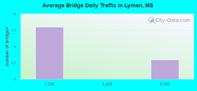
- 40,275Total average daily traffic
- 2,946Total average daily truck traffic
- 48,225Total future (year 2030) average daily traffic
- National Bridge Inventory (NBI) Registered Bridges for Lyman
- No street view available for this location
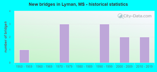
- New bridges - historical statistics
- 11950-1959
- 31970-1979
- 31990-1999
- 22000-2009
- 22010-2019
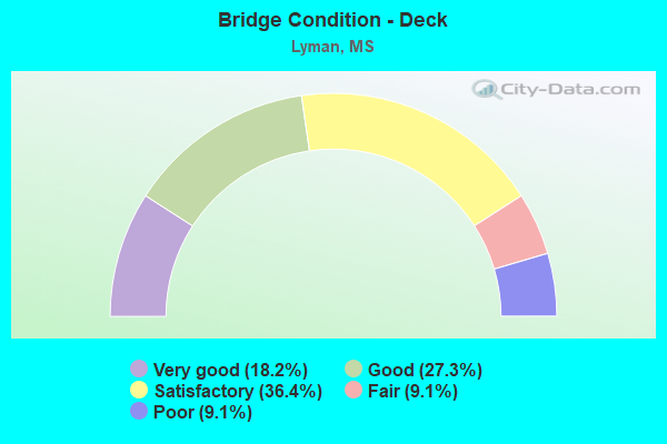
- Bridge Condition - Deck
- 18.2%Very good
- 27.3%Good
- 36.4%Satisfactory
- 9.1%Fair
- 9.1%Poor
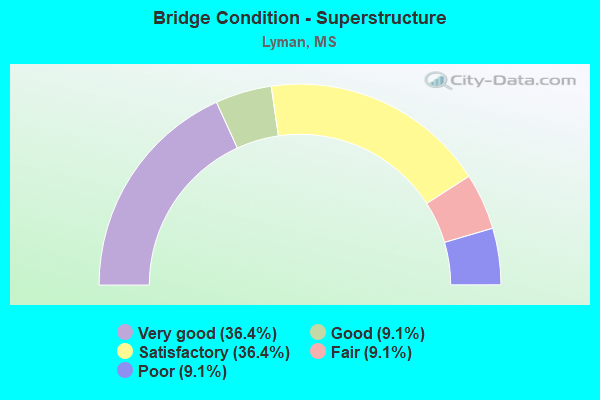
- Bridge Condition - Superstructure
- 36.4%Very good
- 9.1%Good
- 36.4%Satisfactory
- 9.1%Fair
- 9.1%Poor
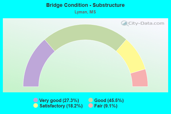
- Bridge Condition - Substructure
- 27.3%Very good
- 45.5%Good
- 18.2%Satisfactory
- 9.1%Fair
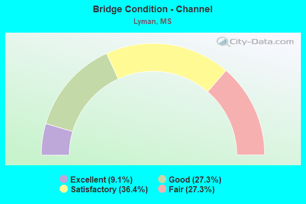
- Bridge Condition - Channel
- 9.1%Excellent
- 27.3%Good
- 36.4%Satisfactory
- 27.3%Fair
Find on map >> Show street view
Structure Number: 21000490240112A, Location: 6.4 MI N I 10 (Lat: 30.523425, Lng: -89.108708), Route carried "on" structure: US 49, Year Built: 2015, Status: Open, Structure Length: 17.73m (58.17ft), Average Daily Traffic: 9,000 (year 2020), Truck Traffic: 7%, Average Future Daily Traffic: 9,500 (year 2040), Design Load: HL 93, Features Intersected: LITTLE BILOXI RIVER
Minimum Vertical Clearance: 30+ m (98+ ft), Kilometerpoint: 17.457, Lanes on structure: 2, Base Highway Network: Yes (Inventory Route: 4, Subroute: 1), Owner: State Highway Agency, Approaching Roadway Width: 16.5m (54.1ft), Material/Design: Prestressed concrete, Design/Construction: Stringer/Multi-beam, Number Of Spans In Main Unit: 1, Number Of Approach Spans: 10, Length of Maximum Span: 30.5m (100.1ft), Curb-To-Curb Width: 16.5m (54.1ft), Out-to-Out Width: 17.3m (56.8ft)
Condition: Deck: Very good, Superstructure: Very good, Substructure: Very good, Channel: Satisfactory, Operating Rating: 50.8 metric tons, Method Used To Determine Operating Rating: Load and Resistance Factor (LRFR), Inventory Rating: 36.2 metric tons, Method Used To Determine Inventory Rating: Load and Resistance Factor (LRFR), Structural Evaluation: Equal to present desirable criteria, Deck Geometry: Superior to present desirable criteria, Waterway Adequacy: Equal to present desirable criteria, Approach Roadway Alignment: Equal to present desirable criteria, Designated Inspection Frequency: Every 24 months, Inspection Date: April 2021, Deck Structure Type: Concrete Cast-file-Place
Find on map >> Show street view
Structure Number: 21000490240112B, Location: 6.4 MI N I 10 (Lat: 30.521939, Lng: -89.108439), Route carried "on" structure: US 49, Year Built: 2015, Status: Open, Structure Length: 17.73m (58.17ft), Average Daily Traffic: 9,000 (year 2020), Truck Traffic: 7%, Average Future Daily Traffic: 9,500 (year 2040), Design Load: HL 93, Features Intersected: LITTLE BILOXI RIVER
Minimum Vertical Clearance: 30+ m (98+ ft), Kilometerpoint: 17.513, Lanes on structure: 3, Base Highway Network: Yes (Inventory Route: 4, Subroute: 1), Owner: State Highway Agency, Approaching Roadway Width: 16.5m (54.1ft), Material/Design: Prestressed concrete, Design/Construction: Stringer/Multi-beam, Number Of Spans In Main Unit: 1, Number Of Approach Spans: 10, Length of Maximum Span: 30.5m (100.1ft), Curb-To-Curb Width: 16.5m (54.1ft), Out-to-Out Width: 17.3m (56.8ft)
Condition: Deck: Very good, Superstructure: Very good, Substructure: Very good, Channel: Good, Operating Rating: 50.8 metric tons, Method Used To Determine Operating Rating: Load and Resistance Factor (LRFR), Inventory Rating: 36.2 metric tons, Method Used To Determine Inventory Rating: Load and Resistance Factor (LRFR), Structural Evaluation: Equal to present desirable criteria, Deck Geometry: Better than present minimum criteria, Waterway Adequacy: Equal to present desirable criteria, Approach Roadway Alignment: Equal to present desirable criteria, Designated Inspection Frequency: Every 24 months, Inspection Date: April 2021, Deck Structure Type: Concrete Cast-file-Place
Find on map >> Show street view
Structure Number: 21000490240138B, Location: 9.0 MI N I 10 (Lat: 30.557953, Lng: -89.121786), Route carried "on" structure: US 49, Year Built: 1959, Status: Open, Structure Length: 16.46m (54.00ft), Average Daily Traffic: 9,000 (year 2020), Truck Traffic: 7%, Average Future Daily Traffic: 9,500 (year 2040), Design Load: HS 20, Features Intersected: BIG BILOXI RIVER
Minimum Vertical Clearance: 30+ m (98+ ft), Kilometerpoint: 21.750, Lanes on structure: 2, Base Highway Network: Yes (Inventory Route: 4, Subroute: 1), Owner: State Highway Agency, Approaching Roadway Width: 12.2m (40.0ft), Material/Design: Steel continuous, Design/Construction: Stringer/Multi-beam, Number Of Spans In Main Unit: 1, Number Of Approach Spans: 13, Length of Maximum Span: 27.4m (89.9ft), Curb-To-Curb Width: 8.5m (27.9ft), Out-to-Out Width: 10.0m (32.8ft)
Condition: Deck: Satisfactory, Superstructure: Satisfactory, Substructure: Good, Channel: Fair, Operating Rating: 45.2 metric tons, Method Used To Determine Operating Rating: Load Factor (LF), Inventory Rating: 27.0 metric tons, Method Used To Determine Inventory Rating: Load Factor (LF), Structural Evaluation: Equal to present minimum criteria, Deck Geometry: High priority of corrective action, Waterway Adequacy: Equal to present desirable criteria, Approach Roadway Alignment: Equal to present desirable criteria, Length Of Structure Improvement: 20.45m (67.09ft), Designated Inspection Frequency: Every 24 months, Inspection Date: May 2021, Bridge Improvement Cost: $999,999,000, Roadway Improvement Cost: $196,000,000, Total Project Cost: $999,999,000, Deck Structure Type: Concrete Cast-file-Place
Find on map >> Show street view
Structure Number: SA2400000000054, Location: SEC 8 T 6S R11W (Lat: 30.541186, Lng: -89.120981), Route carried "on" structure: County highway 8597, Year Built: 1974, Status: Open, Structure Length: 1.74m (5.71ft), Average Daily Traffic: 800 (year 2020), Truck Traffic: 8%, Average Future Daily Traffic: 1,200 (year 2040), Design Load: H 15, Features Intersected: LITTLE BILOXI RIVER BR, Facility Carried by Structure: KELLOGG ROAD
Minimum Vertical Clearance: 30+ m (98+ ft), Kilometerpoint: 0.643, Lanes on structure: 2, Owner: County Highway Agency, Approaching Roadway Width: 5.9m (19.4ft), Material/Design: Concrete, Design/Construction: Channel Beam, Number Of Spans In Main Unit: 3, Length of Maximum Span: 5.8m (19.0ft), Curb or Sidewalk Widths: Left: 0.2m (0.7ft), Right: 0.2m (0.7ft), Curb-To-Curb Width: 8.2m (26.9ft), Out-to-Out Width: 8.6m (28.2ft)
Condition: Deck: Satisfactory, Superstructure: Satisfactory, Substructure: Satisfactory, Channel: Good, Operating Rating: 54.9 metric tons, Method Used To Determine Operating Rating: Load Factor (LF), Inventory Rating: 32.9 metric tons, Method Used To Determine Inventory Rating: Load Factor (LF), Structural Evaluation: Equal to present minimum criteria, Deck Geometry: Somewhat better than minimum adequacy, Waterway Adequacy: Better than present minimum criteria, Approach Roadway Alignment: Equal to present desirable criteria, Length Of Structure Improvement: 1.74m (5.71ft), Designated Inspection Frequency: Every 24 months, Inspection Date: October 2020, Bridge Improvement Cost: $3,000, Roadway Improvement Cost: $1,000, Total Project Cost: $4,000, Deck Structure Type: Concrete Precast Panels, Wearing Surface/Protective System: Wearing Surface: Monolithic Concrete
Find on map >> Show street view
Structure Number: SA2400000000056, Location: SEC 17 T 6S R11W B (Lat: 30.528889, Lng: -89.118611), Route carried "on" structure: County highway 1143, Year Built: 2008, Status: Open, Structure Length: 7.32m (24.02ft), Average Daily Traffic: 1,200 (year 2009), Truck Traffic: 8%, Average Future Daily Traffic: 1,800 (year 2030), Design Load: HS 20, Features Intersected: LITTLE BILOXI RIVER
Minimum Vertical Clearance: 30+ m (98+ ft), Kilometerpoint: 21.887, Lanes on structure: 2, Owner: County Highway Agency, Approaching Roadway Width: 9.1m (29.9ft), Material/Design: Prestressed concrete, Design/Construction: Stringer/Multi-beam, Number Of Spans In Main Unit: 1, Number Of Approach Spans: 4, Length of Maximum Span: 24.4m (80.1ft), Curb or Sidewalk Widths: Left: 0.3m (1.0ft), Right: 0.3m (1.0ft), Curb-To-Curb Width: 8.6m (28.2ft), Out-to-Out Width: 9.2m (30.2ft)
Condition: Deck: Good, Superstructure: Very good, Substructure: Very good, Channel: Good, Operating Rating: 58.2 metric tons, Method Used To Determine Operating Rating: Load Factor (LF), Inventory Rating: 28.1 metric tons, Method Used To Determine Inventory Rating: Load Factor (LF), Structural Evaluation: Better than present minimum criteria, Deck Geometry: Somewhat better than minimum adequacy, Waterway Adequacy: Equal to present desirable criteria, Approach Roadway Alignment: Equal to present desirable criteria, Designated Inspection Frequency: Every 24 months, Inspection Date: January 2021, Deck Structure Type: Concrete Cast-file-Place, Wearing Surface/Protective System: Wearing Surface: Monolithic Concrete
Find on map >> Show street view
Structure Number: SA2400000000057, Location: SEC 18 T 6S R11W (Lat: 30.524672, Lng: -89.137147), Route carried "on" structure: County highway 42, Year Built: 1994, Status: Posted for load, Structure Length: 1.16m (3.81ft), Average Daily Traffic: 75 (year 2021), Average Future Daily Traffic: 125 (year 2041), Design Load: H 15, Features Intersected: BR OF LITTLE BILOXI R, Facility Carried by Structure: MARK WEST ROAD
Minimum Vertical Clearance: 30+ m (98+ ft), Kilometerpoint: 2.414, Lanes on structure: 2, Owner: County Highway Agency, Approaching Roadway Width: 4.9m (16.1ft), Material/Design: Concrete, Design/Construction: Channel Beam, Number Of Spans In Main Unit: 2, Length of Maximum Span: 5.8m (19.0ft), Curb or Sidewalk Widths: Left: 0.2m (0.7ft), Right: 0.2m (0.7ft), Curb-To-Curb Width: 8.1m (26.6ft), Out-to-Out Width: 8.6m (28.2ft)
Condition: Deck: Poor, Superstructure: Poor, Substructure: Good, Channel: Satisfactory, Operating Rating: 36.6 metric tons, Method Used To Determine Operating Rating: Load Factor (LF), Inventory Rating: 21.9 metric tons, Method Used To Determine Inventory Rating: Load Factor (LF), Structural Evaluation: Meets minimum limits, Deck Geometry: Equal to present minimum criteria, Waterway Adequacy: Equal to present desirable criteria, Approach Roadway Alignment: Equal to present minimum criteria, Length Of Structure Improvement: 1.16m (3.81ft), Designated Inspection Frequency: Every 12 months, Inspection Date: October 2021, Bridge Improvement Cost: $1,000, Roadway Improvement Cost: $1,000, Total Project Cost: $2,000, Deck Structure Type: Concrete Precast Panels, Wearing Surface/Protective System: Wearing Surface: Monolithic Concrete
Find on map >> Show street view
Structure Number: SA2400000000063, Location: SEC 11 T 6S R12W (Lat: 30.541944, Lng: -89.169167), Route carried "on" structure: County highway 8077, Year Built: 2002, Status: Open, Structure Length: 9.76m (32.02ft), Average Daily Traffic: 2,000 (year 2009), Truck Traffic: 8%, Average Future Daily Traffic: 3,000 (year 2030), Design Load: HS 20, Features Intersected: LITTLE BILOXI RIVER, Facility Carried by Structure: SHAW ROAD
Minimum Vertical Clearance: 30+ m (98+ ft), Kilometerpoint: 2.896, Lanes on structure: 2, Owner: County Highway Agency, Approaching Roadway Width: 15.3m (50.2ft), Material/Design: Prestressed concrete, Design/Construction: Stringer/Multi-beam, Number Of Spans In Main Unit: 8, Length of Maximum Span: 12.2m (40.0ft), Curb or Sidewalk Widths: Left: 0.3m (1.0ft), Right: 0.3m (1.0ft), Curb-To-Curb Width: 12.2m (40.0ft), Out-to-Out Width: 12.8m (42.0ft)
Condition: Deck: Good, Superstructure: Very good, Substructure: Good, Channel: Fair, Operating Rating: 62.1 metric tons, Method Used To Determine Operating Rating: Load Factor (LF), Inventory Rating: 37.6 metric tons, Method Used To Determine Inventory Rating: Load Factor (LF), Structural Evaluation: Better than present minimum criteria, Deck Geometry: Better than present minimum criteria, Waterway Adequacy: Equal to present desirable criteria, Approach Roadway Alignment: Equal to present desirable criteria, Designated Inspection Frequency: Every 24 months, Inspection Date: January 2021, Deck Structure Type: Concrete Cast-file-Place, Wearing Surface/Protective System: Wearing Surface: Monolithic Concrete
Find on map >> Show street view
Structure Number: SA2400000000065, Location: SEC 34 T 6S R12W B (Lat: 30.484317, Lng: -89.183036), Route carried "on" structure: County highway 147, Year Built: 1974, Status: Open, Structure Length: 2.90m (9.51ft), Average Daily Traffic: 3,000 (year 2020), Truck Traffic: 8%, Average Future Daily Traffic: 4,500 (year 2040), Design Load: HS 15, Features Intersected: BAYOU BERNARD
Minimum Vertical Clearance: 30+ m (98+ ft), Kilometerpoint: 15.288, Lanes on structure: 2, Owner: County Highway Agency, Approaching Roadway Width: 7.0m (23.0ft), Material/Design: Concrete, Design/Construction: Channel Beam, Number Of Spans In Main Unit: 5, Length of Maximum Span: 5.8m (19.0ft), Curb-To-Curb Width: 8.1m (26.6ft), Out-to-Out Width: 8.6m (28.2ft)
Condition: Deck: Fair, Superstructure: Fair, Substructure: Fair, Channel: Fair, Operating Rating: 53.2 metric tons, Method Used To Determine Operating Rating: Load Factor (LF), Inventory Rating: 31.9 metric tons, Method Used To Determine Inventory Rating: Load Factor (LF), Structural Evaluation: Somewhat better than minimum adequacy, Deck Geometry: High priority of corrective action, Waterway Adequacy: Superior to present desirable criteria, Approach Roadway Alignment: Equal to present desirable criteria, Length Of Structure Improvement: 3.81m (12.50ft), Designated Inspection Frequency: Every 24 months, Inspection Date: October 2020, Bridge Improvement Cost: $4,000, Roadway Improvement Cost: $1,000, Total Project Cost: $5,000, Deck Structure Type: Concrete Cast-file-Place, Wearing Surface/Protective System: Wearing Surface: Monolithic Concrete
Find on map >> Show street view
Structure Number: SA2400000000119, Location: SEC 2 T 7S R12W (Lat: 30.471111, Lng: -89.160278), Route carried "on" structure: County highway 2209, Year Built: 1997, Status: Open, Structure Length: 2.85m (9.35ft), Average Daily Traffic: 2,000 (year 2011), Truck Traffic: 8%, Average Future Daily Traffic: 3,000 (year 2032), Design Load: HS 20, Features Intersected: BAYOU BERNARD, Facility Carried by Structure: ROBINSON ROAD
Minimum Vertical Clearance: 30+ m (98+ ft), Kilometerpoint: 2.896, Lanes on structure: 2, Owner: County Highway Agency, Approaching Roadway Width: 11.2m (36.7ft), Material/Design: Concrete, Design/Construction: Channel Beam, Number Of Spans In Main Unit: 3, Length of Maximum Span: 9.5m (31.2ft), Curb-To-Curb Width: 8.5m (27.9ft), Out-to-Out Width: 9.5m (31.2ft)
Condition: Deck: Good, Superstructure: Good, Substructure: Good, Channel: Satisfactory, Operating Rating: 63.7 metric tons, Method Used To Determine Operating Rating: Load Factor (LF), Inventory Rating: 37.9 metric tons, Method Used To Determine Inventory Rating: Load Factor (LF), Structural Evaluation: Better than present minimum criteria, Deck Geometry: Somewhat better than minimum adequacy, Waterway Adequacy: Superior to present desirable criteria, Approach Roadway Alignment: Equal to present desirable criteria, Designated Inspection Frequency: Every 24 months, Inspection Date: March 2020, Deck Structure Type: Concrete Precast Panels, Wearing Surface/Protective System: Wearing Surface: Monolithic Concrete
Find on map >> Show street view
Structure Number: SA240000000012, Location: SEC 4 T 7S R12W B (Lat: 30.465519, Lng: -89.190589), Route carried "on" structure: County highway 147, Year Built: 1974, Status: Open, Structure Length: 1.74m (5.71ft), Average Daily Traffic: 2,200 (year 2020), Truck Traffic: 8%, Average Future Daily Traffic: 3,100 (year 2040), Design Load: H 15, Features Intersected: SANDY CREEK BRANCH
Minimum Vertical Clearance: 30+ m (98+ ft), Kilometerpoint: 12.874, Lanes on structure: 2, Owner: County Highway Agency, Approaching Roadway Width: 6.7m (22.0ft), Material/Design: Concrete, Design/Construction: Channel Beam, Number Of Spans In Main Unit: 3, Length of Maximum Span: 5.8m (19.0ft), Curb or Sidewalk Widths: Left: 0.2m (0.7ft), Right: 0.2m (0.7ft), Curb-To-Curb Width: 8.1m (26.6ft), Out-to-Out Width: 8.5m (27.9ft)
Condition: Deck: Satisfactory, Superstructure: Satisfactory, Substructure: Satisfactory, Channel: Satisfactory, Operating Rating: 54.9 metric tons, Method Used To Determine Operating Rating: Load Factor (LF), Inventory Rating: 32.9 metric tons, Method Used To Determine Inventory Rating: Load Factor (LF), Structural Evaluation: Equal to present minimum criteria, Deck Geometry: High priority of corrective action, Waterway Adequacy: Superior to present desirable criteria, Approach Roadway Alignment: Equal to present desirable criteria, Length Of Structure Improvement: 0.40m (1.31ft), Designated Inspection Frequency: Every 24 months, Inspection Date: December 2020, Bridge Improvement Cost: $1,000, Roadway Improvement Cost: $1,000, Total Project Cost: $2,000, Deck Structure Type: Concrete Precast Panels, Wearing Surface/Protective System: Wearing Surface: Monolithic Concrete
Find on map >> Show street view
Structure Number: SA2400000000178, Location: SEC 1 T 7S R12W (Lat: 30.471111, Lng: -89.149722), Route carried "on" structure: County highway 2209, Year Built: 1997, Status: Open, Structure Length: 1.74m (5.71ft), Average Daily Traffic: 2,000 (year 2012), Truck Traffic: 8%, Average Future Daily Traffic: 3,000 (year 2032), Design Load: H 15, Features Intersected: ECHO HILLS CREEK, Facility Carried by Structure: ROBINSON ROAD
Minimum Vertical Clearance: 30+ m (98+ ft), Kilometerpoint: 3.500, Lanes on structure: 2, Owner: County Highway Agency, Approaching Roadway Width: 11.3m (37.1ft), Material/Design: Concrete, Design/Construction: Channel Beam, Number Of Spans In Main Unit: 3, Length of Maximum Span: 5.8m (19.0ft), Curb-To-Curb Width: 9.3m (30.5ft), Out-to-Out Width: 11.5m (37.7ft)
Condition: Deck: Satisfactory, Superstructure: Satisfactory, Substructure: Good, Channel: Excellent, Operating Rating: 58.8 metric tons, Method Used To Determine Operating Rating: Load Factor (LF), Inventory Rating: 35.3 metric tons, Method Used To Determine Inventory Rating: Load Factor (LF), Structural Evaluation: Equal to present minimum criteria, Deck Geometry: Somewhat better than minimum adequacy, Waterway Adequacy: Superior to present desirable criteria, Approach Roadway Alignment: Better than present minimum criteria, Length Of Structure Improvement: 1.74m (5.71ft), Designated Inspection Frequency: Every 24 months, Inspection Date: March 2020, Bridge Improvement Cost: $2,000, Roadway Improvement Cost: $1,000, Total Project Cost: $3,000, Deck Structure Type: Concrete Precast Panels, Wearing Surface/Protective System: Wearing Surface: Monolithic Concrete