Bridge Statistics for Maize, Kansas (KS)
Condition, Traffic, Stress, Structural Evaluation, Project Costs
- National Bridge Inventory (NBI) Statistics
- 28Number of bridges
- 328ft / 99.9mTotal length
- $850,000Total costs
- 111,427Total average daily traffic
- 11,030Total average daily truck traffic
- National Bridge Inventory (NBI) Registered Bridges for Maize
- No street view available for this location
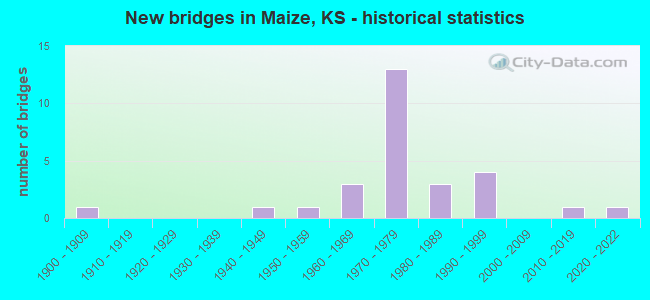
- New bridges - historical statistics
- 11900-1909
- 11940-1949
- 11950-1959
- 31960-1969
- 131970-1979
- 31980-1989
- 41990-1999
- 12010-2019
- 12020-2022
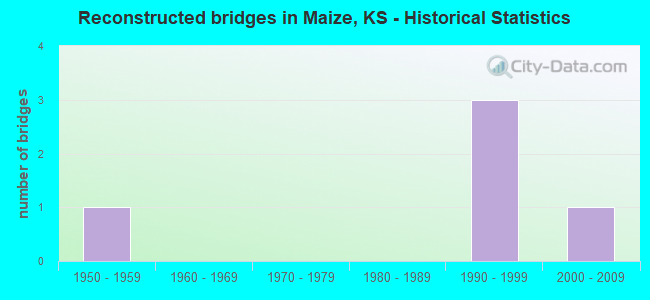
- Reconstructed bridges - Historical Statistics
- 11950-1959
- 01960-1969
- 01970-1979
- 01980-1989
- 31990-1999
- 12000-2009
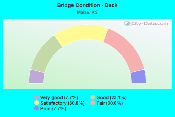
- Bridge Condition - Deck
- 7.7%Very good
- 23.1%Good
- 30.8%Satisfactory
- 30.8%Fair
- 7.7%Poor
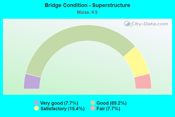
- Bridge Condition - Superstructure
- 7.7%Very good
- 69.2%Good
- 15.4%Satisfactory
- 7.7%Fair
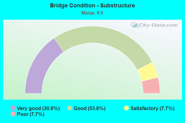
- Bridge Condition - Substructure
- 30.8%Very good
- 53.8%Good
- 7.7%Satisfactory
- 7.7%Poor
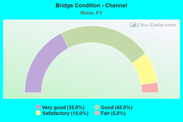
- Bridge Condition - Channel
- 35.0%Very good
- 45.0%Good
- 15.0%Satisfactory
- 5.0%Fair
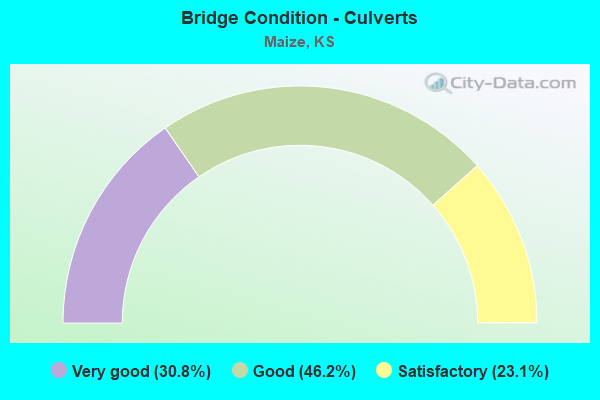
- Bridge Condition - Culverts
- 30.8%Very good
- 46.2%Good
- 23.1%Satisfactory
Find on map >> Show street view
Structure Number: 8703, Location: 3.0W 1.5S VALLEY CENTER (Lat: 37.810608, Lng: -97.443628), Route carried "on" structure: County highway 998, Year Built: 1972, Year Reconstructed: 2011, Status: Open, Structure Length: 21.12m (69.29ft), Average Daily Traffic: 3,986 (year 2018), Truck Traffic: 10%, Average Future Daily Traffic: 4,864 (year 2038), Design Load: HS 20, Features Intersected: BIG ARKANSAS RIVER
Minimum Vertical Clearance: 30.47m (99.97ft), Kilometerpoint: 0.000, Lanes on structure: 2, Owner: County Highway Agency, Approaching Roadway Width: 15.8m (51.8ft), Material/Design: Prestressed concrete continuous, Design/Construction: Tee Beam, Number Of Spans In Main Unit: 12, Length of Maximum Span: 17.7m (58.1ft), Curb-To-Curb Width: 13.5m (44.3ft), Out-to-Out Width: 14.1m (46.3ft)
Condition: Deck: Satisfactory, Superstructure: Satisfactory, Substructure: Poor, Channel: Fair, Operating Rating: 40.5 metric tons, Method Used To Determine Operating Rating: Load Factor (LF), Inventory Rating: 32.4 metric tons, Method Used To Determine Inventory Rating: Load Factor (LF), Structural Evaluation: Meets minimum limits, Deck Geometry: Superior to present desirable criteria, Waterway Adequacy: Better than present minimum criteria, Approach Roadway Alignment: Equal to present desirable criteria, Length Of Structure Improvement: 1.22m (4.00ft), Designated Inspection Frequency: Every 24 months, Inspection Date: September 2021, Bridge Improvement Cost: $400,000, Total Project Cost: $400,000 ( Estimate for 2021), Deck Structure Type: Concrete Cast-file-Place, Wearing Surface/Protective System: Wearing Surface: Low Slump Concrete
Find on map >> Show street view
Structure Number: 87144, Location: 53rdN, 0.6 E of 87thW (Lat: 37.781239, Lng: -97.434292), Route carried "on" structure: County highway 1805, Year Built: 1900, Year Reconstructed: 1950, Status: Open, Structure Length: 1.31m (4.30ft), Average Daily Traffic: 4,989 (year 2018), Truck Traffic: 6%, Average Future Daily Traffic: 6,088 (year 2038), Features Intersected: LITTLE SLOUGH
Minimum Vertical Clearance: 30.47m (99.97ft), Kilometerpoint: 0.000, Lanes on structure: 2, Owner: County Highway Agency, Approaching Roadway Width: 12.8m (42.0ft), Material/Design: Concrete, Design/Construction: Culvert, Number Of Spans In Main Unit: 6, Length of Maximum Span: 1.8m (5.9ft), Curb-To-Curb Width: 13.4m (44.0ft), Out-to-Out Width: 13.9m (45.6ft)
Condition: Channel: Good, Culverts: Satisfactory, Operating Rating: 22.5 metric tons, Method Used To Determine Operating Rating: Load Factor (LF), Inventory Rating: 17.1 metric tons, Method Used To Determine Inventory Rating: Load Factor (LF), Structural Evaluation: Meets minimum limits, Deck Geometry: Better than present minimum criteria, Waterway Adequacy: Better than present minimum criteria, Approach Roadway Alignment: Equal to present desirable criteria, Designated Inspection Frequency: Every 24 months, Inspection Date: August 2021, Deck Structure Type: Concrete Cast-file-Place, Wearing Surface/Protective System: Wearing Surface: Bituminous
Find on map >> Show street view
Structure Number: 87145, Location: 53rdN, 0.3 E of 103rdW (Lat: 37.780953, Lng: -97.458217), Route carried "on" structure: County highway 1805, Year Built: 1950, Status: Open, Structure Length: 2.71m (8.89ft), Average Daily Traffic: 4,228 (year 2018), Truck Traffic: 8%, Average Future Daily Traffic: 5,157 (year 2038), Features Intersected: BIG SLOUGH
Minimum Vertical Clearance: 30.47m (99.97ft), Kilometerpoint: 0.000, Lanes on structure: 2, Owner: County Highway Agency, Approaching Roadway Width: 24.4m (80.1ft), Skew: 20 degrees, Material/Design: Concrete, Design/Construction: Culvert, Number Of Spans In Main Unit: 8, Length of Maximum Span: 2.4m (7.9ft), Curb-To-Curb Width: 26.6m (87.3ft), Out-to-Out Width: 27.1m (88.9ft)
Condition: Channel: Satisfactory, Culverts: Satisfactory, Operating Rating: 22.5 metric tons, Method Used To Determine Operating Rating: Load Factor (LF), Inventory Rating: 17.1 metric tons, Method Used To Determine Inventory Rating: Load Factor (LF), Structural Evaluation: Meets minimum limits, Deck Geometry: Superior to present desirable criteria, Waterway Adequacy: Better than present minimum criteria, Approach Roadway Alignment: Better than present minimum criteria, Designated Inspection Frequency: Every 24 months, Inspection Date: August 2021, Deck Structure Type: Concrete Cast-file-Place, Wearing Surface/Protective System: Wearing Surface: Bituminous
Find on map >> Show street view
Structure Number: 870803006025, Location: 135thW, 0.54 N of 61stN (Lat: 37.802389, Lng: -97.500250), Route carried "on" structure: County highway 8729, Year Built: 2020, Status: Open, Structure Length: 0.67m (2.20ft), Average Daily Traffic: 40 (year 2020), Average Future Daily Traffic: 45 (year 2040), Design Load: HL 93, Features Intersected: TRIB. BIG ARKANSAS RIVER, Facility Carried by Structure: 135th W RurMinCol
Minimum Vertical Clearance: 30.47m (99.97ft), Kilometerpoint: 0.000, Lanes on structure: 2, Owner: County Highway Agency, Approaching Roadway Width: 6.4m (21.0ft), Material/Design: Concrete, Design/Construction: Culvert, Number Of Spans In Main Unit: 2, Length of Maximum Span: 3.0m (9.8ft), Curb-To-Curb Width: 8.7m (28.5ft), Out-to-Out Width: 9.3m (30.5ft)
Condition: Channel: Very good, Culverts: Very good, Operating Rating: 45.0 metric tons, Method Used To Determine Operating Rating: Load Factor (LF), Inventory Rating: 34.6 metric tons, Method Used To Determine Inventory Rating: Load Factor (LF), Structural Evaluation: Equal to present desirable criteria, Deck Geometry: Better than present minimum criteria, Waterway Adequacy: Somewhat better than minimum adequacy, Approach Roadway Alignment: Equal to present desirable criteria, Designated Inspection Frequency: Every 24 months, Inspection Date: July 2021, Deck Structure Type: Concrete Precast Panels, Wearing Surface/Protective System: Wearing Surface: Gravel
Find on map >> Show street view
Structure Number: 87080310604, Location: 61stN, 0.9 E of 135thW (Lat: 37.794739, Lng: -97.490708), Route carried "on" structure: County highway , Year Built: 1990, Status: Open, Structure Length: 0.76m (2.49ft), Average Daily Traffic: 25 (year 2018), Average Future Daily Traffic: 40 (year 2038), Design Load: H 20, Features Intersected: TRIB. BIG SLOUGH, Facility Carried by Structure: W 61st LOCAL RD.
Minimum Vertical Clearance: 30.47m (99.97ft), Kilometerpoint: 0.000, Lanes on structure: 2, Owner: County Highway Agency, Approaching Roadway Width: 7.9m (25.9ft), Material/Design: Steel, Design/Construction: Stringer/Multi-beam, Number Of Spans In Main Unit: 1, Length of Maximum Span: 7.3m (24.0ft), Curb-To-Curb Width: 8.5m (27.9ft), Out-to-Out Width: 8.5m (27.9ft)
Condition: Deck: Good, Superstructure: Good, Substructure: Very good, Channel: Satisfactory, Operating Rating: 27.9 metric tons, Method Used To Determine Operating Rating: Load Factor (LF), Inventory Rating: 22.5 metric tons, Method Used To Determine Inventory Rating: Load Factor (LF), Structural Evaluation: Equal to present minimum criteria, Deck Geometry: Better than present minimum criteria, Waterway Adequacy: Equal to present minimum criteria, Approach Roadway Alignment: Equal to present minimum criteria, Designated Inspection Frequency: Every 24 months, Inspection Date: July 2021, Deck Structure Type: Corrugated Steel, Wearing Surface/Protective System: Wearing Surface: Bituminous
Find on map >> Show street view
Structure Number: 87080350612, Location: 29thN, 0.5 E of 135thW (Lat: 37.736731, Lng: -97.489722), Route carried "on" structure: County highway , Year Built: 1998, Status: Open, Structure Length: 4.36m (14.30ft), Average Daily Traffic: 3,697 (year 2018), Truck Traffic: 3%, Average Future Daily Traffic: 4,511 (year 2038), Design Load: HS 20, Features Intersected: COWSKIN CREEK, Facility Carried by Structure: W 29th LOCAL RD.
Minimum Vertical Clearance: 30.47m (99.97ft), Kilometerpoint: 0.000, Lanes on structure: 2, Owner: County Highway Agency, Approaching Roadway Width: 8.5m (27.9ft), Material/Design: Concrete continuous, Design/Construction: Slab, Number Of Spans In Main Unit: 3, Length of Maximum Span: 16.8m (55.1ft), Curb-To-Curb Width: 8.5m (27.9ft), Out-to-Out Width: 9.1m (29.9ft)
Condition: Deck: Satisfactory, Superstructure: Good, Substructure: Good, Channel: Very good, Operating Rating: 71.1 metric tons, Method Used To Determine Operating Rating: Load Factor (LF), Inventory Rating: 42.5 metric tons, Method Used To Determine Inventory Rating: Load Factor (LF), Structural Evaluation: Better than present minimum criteria, Deck Geometry: Meets minimum limits, Waterway Adequacy: Equal to present minimum criteria, Approach Roadway Alignment: Better than present minimum criteria, Designated Inspection Frequency: Every 24 months, Inspection Date: July 2021, Deck Structure Type: Concrete Cast-file-Place, Wearing Surface/Protective System: Wearing Surface: Monolithic Concrete
Find on map >> Show street view
Structure Number: 87080550598, Location: 85thN, 0.5 E of 119thW (Lat: 37.839572, Lng: -97.473575), Route carried "on" structure: County highway , Year Built: 1989, Status: Open, Structure Length: 3.63m (11.91ft), Average Daily Traffic: 50 (year 2018), Average Future Daily Traffic: 80 (year 2038), Design Load: HS 20, Features Intersected: MAIN DITCH, Facility Carried by Structure: 85th LOCAL RD.
Minimum Vertical Clearance: 30.47m (99.97ft), Kilometerpoint: 0.000, Lanes on structure: 2, Owner: County Highway Agency, Approaching Roadway Width: 8.5m (27.9ft), Skew: 4 degrees, Material/Design: Concrete continuous, Design/Construction: Slab, Number Of Spans In Main Unit: 3, Length of Maximum Span: 13.7m (44.9ft), Curb-To-Curb Width: 8.5m (27.9ft), Out-to-Out Width: 9.1m (29.9ft)
Condition: Deck: Satisfactory, Superstructure: Good, Substructure: Good, Channel: Very good, Operating Rating: 68.4 metric tons, Method Used To Determine Operating Rating: Load Factor (LF), Inventory Rating: 40.9 metric tons, Method Used To Determine Inventory Rating: Load Factor (LF), Structural Evaluation: Better than present minimum criteria, Deck Geometry: Better than present minimum criteria, Waterway Adequacy: Equal to present desirable criteria, Approach Roadway Alignment: Equal to present minimum criteria, Designated Inspection Frequency: Every 24 months, Inspection Date: August 2021, Deck Structure Type: Concrete Cast-file-Place, Wearing Surface/Protective System: Wearing Surface: Monolithic Concrete
Find on map >> Show street view
Structure Number: 870807006365, Location: 103rdW, 0.6 N of 79thS (Lat: 37.556911, Lng: -97.461611), Route carried "on" structure: County highway 8755, Year Built: 2015, Status: Open, Structure Length: 4.35m (14.27ft), Average Daily Traffic: 358 (year 2018), Truck Traffic: 6%, Average Future Daily Traffic: 437 (year 2038), Design Load: HL 93, Features Intersected: SPRING CREEK, Facility Carried by Structure: 103rdW R Min Coll
Minimum Vertical Clearance: 30.47m (99.97ft), Kilometerpoint: 0.000, Lanes on structure: 2, Owner: County Highway Agency, Approaching Roadway Width: 7.9m (25.9ft), Skew: 3 degrees, Material/Design: Concrete continuous, Design/Construction: Slab, Number Of Spans In Main Unit: 3, Length of Maximum Span: 17.1m (56.1ft), Curb-To-Curb Width: 9.7m (31.8ft), Out-to-Out Width: 10.3m (33.8ft)
Condition: Deck: Very good, Superstructure: Very good, Substructure: Very good, Channel: Very good, Operating Rating: 54.1 metric tons, Method Used To Determine Operating Rating: Load and Resistance Factor Rating (LRFR) rating reported by rating factor(RF) method using HL-93 loadings, Inventory Rating: 41.8 metric tons, Method Used To Determine Inventory Rating: Load and Resistance Factor Rating (LRFR) rating reported by rating factor(RF) method using HL-93 loadings, Structural Evaluation: Equal to present desirable criteria, Deck Geometry: Equal to present minimum criteria, Waterway Adequacy: Equal to present desirable criteria, Approach Roadway Alignment: Equal to present desirable criteria, Designated Inspection Frequency: Every 24 months, Inspection Date: July 2020, Other Special Inspection Date: Febuary 2021, Deck Structure Type: Concrete Cast-file-Place, Wearing Surface/Protective System: Wearing Surface: Epoxy Overlay, Membrane: Epoxy, Deck Protection: Epoxy Coated Reinforcing
Find on map >> Show street view
Structure Number: 87080760604, Location: 0.33 Mi. W of Tyler Rd. (Lat: 37.795925, Lng: -97.451808), Route carried "on" structure: City street , Year Built: 1948, Status: Posted for load, Structure Length: 0.85m (2.79ft), Average Daily Traffic: 200 (year 2010), Truck Traffic: 5%, Average Future Daily Traffic: 300 (year 2043), Design Load: H 15, Features Intersected: Big Slough Trib., Facility Carried by Structure: 61st St.
Minimum Vertical Clearance: 30.47m (99.97ft), Kilometerpoint: 0.000, Lanes on structure: 2, Owner: City or Municipal Highway Agency, Approaching Roadway Width: 8.5m (27.9ft), Material/Design: Concrete, Design/Construction: Culvert, Number Of Spans In Main Unit: 4, Length of Maximum Span: 1.8m (5.9ft), Curb-To-Curb Width: 5.9m (19.4ft), Out-to-Out Width: 6.6m (21.7ft)
Condition: Channel: Satisfactory, Culverts: Satisfactory, Operating Rating: 20.9 metric tons, Method Used To Determine Operating Rating: Field evaluation and documented engineering judgment, Inventory Rating: 20.9 metric tons, Method Used To Determine Inventory Rating: Field evaluation and documented engineering judgment, Structural Evaluation: Equal to present minimum criteria, Deck Geometry: High priority of corrective action, Waterway Adequacy: Equal to present minimum criteria, Approach Roadway Alignment: Better than present minimum criteria, Bridge Posting: Required (Relationship of Operating Rating to Maximum Legal Load: > 39.9% below), Length Of Structure Improvement: 6.10m (20.01ft), Designated Inspection Frequency: Every 24 months, Inspection Date: Febuary 2021, Other Special Inspection Date: May 2021, Bridge Improvement Cost: $120,000, Roadway Improvement Cost: $50,000, Total Project Cost: $200,000 ( Estimate for 2015)
Find on map >> Show street view
Structure Number: 870809006041, Location: 600' S. of 61st St. (Lat: 37.794289, Lng: -97.445086), Route carried "on" structure: City street , Year Built: 1970, Status: Posted for load, Structure Length: 0.79m (2.59ft), Average Daily Traffic: 200 (year 2012), Truck Traffic: 5%, Average Future Daily Traffic: 80 (year 2043), Design Load: HS 20, Features Intersected: Little Slough, Facility Carried by Structure: Tyler Rd
Minimum Vertical Clearance: 30.47m (99.97ft), Kilometerpoint: 0.000, Lanes on structure: 2, Owner: City or Municipal Highway Agency, Approaching Roadway Width: 8.5m (27.9ft), Material/Design: Steel, Design/Construction: Culvert, Number Of Spans In Main Unit: 4, Length of Maximum Span: 1.5m (4.9ft), Curb-To-Curb Width: 8.2m (26.9ft), Out-to-Out Width: 8.2m (26.9ft)
Condition: Channel: Good, Culverts: Good, Operating Rating: 24.8 metric tons, Method Used To Determine Operating Rating: Load Factor (LF), Inventory Rating: 14.7 metric tons, Method Used To Determine Inventory Rating: Load Factor (LF), Structural Evaluation: Meets minimum limits, Deck Geometry: Somewhat better than minimum adequacy, Waterway Adequacy: Better than present minimum criteria, Approach Roadway Alignment: Better than present minimum criteria, Length Of Structure Improvement: 3.66m (12.01ft), Designated Inspection Frequency: Every 24 months, Inspection Date: Febuary 2021, Bridge Improvement Cost: $100,000, Roadway Improvement Cost: $20,000, Total Project Cost: $175,000 ( Estimate for 2015)
Find on map >> Show street view
Structure Number: 870809006069, Location: 400' N of 45th St. (Lat: 37.767400, Lng: -97.444781), Route carried "on" structure: City street , Year Built: 1989, Status: Open, Structure Length: 3.60m (11.81ft), Average Daily Traffic: 2,205 (year 2012), Truck Traffic: 6%, Average Future Daily Traffic: 2,700 (year 2043), Design Load: HS 20, Features Intersected: BIG SLOUGH, Facility Carried by Structure: Tyler Rd.
Minimum Vertical Clearance: 30.47m (99.97ft), Kilometerpoint: 0.000, Lanes on structure: 2, Owner: City or Municipal Highway Agency, Approaching Roadway Width: 8.5m (27.9ft), Material/Design: Concrete continuous, Design/Construction: Slab, Number Of Spans In Main Unit: 3, Length of Maximum Span: 13.7m (44.9ft), Curb-To-Curb Width: 8.5m (27.9ft), Out-to-Out Width: 9.1m (29.9ft)
Condition: Deck: Fair, Superstructure: Fair, Substructure: Very good, Channel: Very good, Operating Rating: 65.4 metric tons, Method Used To Determine Operating Rating: Load Factor (LF), Inventory Rating: 39.2 metric tons, Method Used To Determine Inventory Rating: Load Factor (LF), Structural Evaluation: Somewhat better than minimum adequacy, Deck Geometry: Meets minimum limits, Waterway Adequacy: Equal to present desirable criteria, Approach Roadway Alignment: Equal to present desirable criteria, Length Of Structure Improvement: 6.10m (20.01ft), Designated Inspection Frequency: Every 24 months, Inspection Date: Febuary 2021, Bridge Improvement Cost: $50,000, Roadway Improvement Cost: $15,000, Total Project Cost: $75,000, Deck Structure Type: Concrete Cast-file-Place, Wearing Surface/Protective System: Wearing Surface: Monolithic Concrete
Find on map >> Show street view
Structure Number: 87080940608, Location: 45thN, 0.4 E of 87thW (Lat: 37.766392, Lng: -97.437906), Route carried "on" structure: County highway , Year Built: 1987, Status: Open, Structure Length: 3.93m (12.89ft), Average Daily Traffic: 2,775 (year 2018), Truck Traffic: 5%, Average Future Daily Traffic: 3,386 (year 2038), Design Load: HS 20, Features Intersected: BIG SLOUGH, Facility Carried by Structure: 45th
Minimum Vertical Clearance: 30.47m (99.97ft), Kilometerpoint: 0.000, Lanes on structure: 2, Owner: County Highway Agency, Approaching Roadway Width: 8.5m (27.9ft), Material/Design: Concrete continuous, Design/Construction: Slab, Number Of Spans In Main Unit: 4, Length of Maximum Span: 11.0m (36.1ft), Curb-To-Curb Width: 8.5m (27.9ft), Out-to-Out Width: 9.1m (29.9ft)
Condition: Deck: Good, Superstructure: Good, Substructure: Satisfactory, Channel: Very good, Operating Rating: 45.6 metric tons, Method Used To Determine Operating Rating: Load Factor (LF), Inventory Rating: 27.3 metric tons, Method Used To Determine Inventory Rating: Load Factor (LF), Structural Evaluation: Equal to present minimum criteria, Deck Geometry: Meets minimum limits, Waterway Adequacy: Equal to present desirable criteria, Approach Roadway Alignment: Better than present minimum criteria, Designated Inspection Frequency: Every 24 months, Inspection Date: August 2021, Deck Structure Type: Concrete Cast-file-Place, Wearing Surface/Protective System: Wearing Surface: Bituminous
Find on map >> Show street view
Structure Number: 87080990608, Location: 45thN, 0.8 E of 87thW (Lat: 37.766544, Lng: -97.446681), Route carried "on" structure: County highway , Year Built: 1993, Status: Open, Structure Length: 1.28m (4.20ft), Average Daily Traffic: 2,775 (year 2018), Truck Traffic: 5%, Average Future Daily Traffic: 3,386 (year 2038), Design Load: HS 20, Features Intersected: LITTLE SLOUGH, Facility Carried by Structure: 45th
Minimum Vertical Clearance: 30.47m (99.97ft), Kilometerpoint: 0.000, Lanes on structure: 2, Owner: County Highway Agency, Approaching Roadway Width: 8.5m (27.9ft), Material/Design: Concrete, Design/Construction: Culvert, Number Of Spans In Main Unit: 5, Length of Maximum Span: 2.4m (7.9ft), Curb-To-Curb Width: 8.5m (27.9ft), Out-to-Out Width: 9.0m (29.5ft)
Condition: Channel: Very good, Culverts: Very good, Operating Rating: 58.6 metric tons, Method Used To Determine Operating Rating: Load Factor (LF), Inventory Rating: 35.1 metric tons, Method Used To Determine Inventory Rating: Load Factor (LF), Structural Evaluation: Equal to present desirable criteria, Deck Geometry: Meets minimum limits, Waterway Adequacy: Better than present minimum criteria, Approach Roadway Alignment: Better than present minimum criteria, Designated Inspection Frequency: Every 24 months, Inspection Date: August 2021, Deck Structure Type: Concrete Cast-file-Place, Wearing Surface/Protective System: Wearing Surface: Bituminous
Find on map >> Show street view
Structure Number: 999909600871911, Location: 11.9 MI E RENO COLN (Lat: 37.810556, Lng: -97.501944), Route carried "on" structure: State highway 96, Year Built: 1968, Year Reconstructed: 1996, Status: Open, Structure Length: 0.63m (2.07ft), Average Daily Traffic: 6,568 (year 2020), Truck Traffic: 14%, Average Future Daily Traffic: 10,762 (year 2041), Design Load: H 20, Features Intersected: BIG SLOUGH
Minimum Vertical Clearance: 30.47m (99.97ft), Kilometerpoint: 20.452, Lanes on structure: 4, Base Highway Network: Yes, Owner: State Highway Agency, Approaching Roadway Width: 24.4m (80.1ft), Skew: 20 degrees, Material/Design: Concrete, Design/Construction: Culvert, Number Of Spans In Main Unit: 2, Length of Maximum Span: 3.0m (9.8ft), Curb-To-Curb Width: 24.4m (80.1ft), Out-to-Out Width: 52.9m (173.6ft)
Condition: Channel: Good, Culverts: Good, Operating Rating: 28.0 metric tons, Method Used To Determine Operating Rating: Load Factor (LF), Inventory Rating: 16.8 metric tons, Method Used To Determine Inventory Rating: Load Factor (LF), Structural Evaluation: Meets minimum limits, Deck Geometry: Superior to present desirable criteria, Waterway Adequacy: Better than present minimum criteria, Approach Roadway Alignment: Equal to present desirable criteria, Length Of Structure Improvement: 2.05m (6.73ft), Designated Inspection Frequency: Every 24 months, Inspection Date: September 2020, Deck Structure Type: Concrete Cast-file-Place, Wearing Surface/Protective System: Wearing Surface: Bituminous
Find on map >> Show street view
Structure Number: 999909600871921, Location: 14.2 MI E RENO COLN (Lat: 37.795556, Lng: -97.481944), Route carried "on" structure: State highway 96, Year Built: 1969, Year Reconstructed: 1996, Status: Open, Structure Length: 1.27m (4.17ft), Average Daily Traffic: 6,568 (year 2020), Truck Traffic: 14%, Average Future Daily Traffic: 10,762 (year 2041), Design Load: H 20, Features Intersected: BIG SLOUGH DRAINAGE
Minimum Vertical Clearance: 30.47m (99.97ft), Kilometerpoint: 22.890, Lanes on structure: 4, Base Highway Network: Yes, Owner: State Highway Agency, Approaching Roadway Width: 24.4m (80.1ft), Skew: 20 degrees, Material/Design: Concrete, Design/Construction: Culvert, Number Of Spans In Main Unit: 4, Length of Maximum Span: 3.0m (9.8ft), Curb-To-Curb Width: 24.4m (80.1ft), Out-to-Out Width: 48.8m (160.1ft)
Condition: Channel: Good, Culverts: Good, Operating Rating: 37.4 metric tons, Method Used To Determine Operating Rating: Load Factor (LF), Inventory Rating: 22.3 metric tons, Method Used To Determine Inventory Rating: Load Factor (LF), Structural Evaluation: Somewhat better than minimum adequacy, Deck Geometry: Superior to present desirable criteria, Waterway Adequacy: Equal to present desirable criteria, Approach Roadway Alignment: Equal to present desirable criteria, Length Of Structure Improvement: 4.18m (13.71ft), Designated Inspection Frequency: Every 24 months, Inspection Date: September 2020, Deck Structure Type: Concrete Cast-file-Place, Wearing Surface/Protective System: Wearing Surface: Bituminous
Find on map >> Show street view
Structure Number: 999909600871931, Location: 15.5 MI E RENO CL (Lat: 37.785556, Lng: -97.463056), Route carried "on" structure: ServiceCounty highway 3570, Year Built: 1968, Status: Open, Structure Length: 0.63m (2.07ft), Average Daily Traffic: 99 (year 2020), Average Future Daily Traffic: 10,733 (year 2041), Design Load: H 20, Features Intersected: BIG SLOUGH, Facility Carried by Structure: Maize Road Adj.
Minimum Vertical Clearance: 30.47m (99.97ft), Kilometerpoint: 0.587, Lanes on structure: 2, Owner: State Highway Agency, Approaching Roadway Width: 7.3m (24.0ft), Material/Design: Concrete, Design/Construction: Culvert, Number Of Spans In Main Unit: 2, Length of Maximum Span: 3.0m (9.8ft), Curb-To-Curb Width: 11.0m (36.1ft), Out-to-Out Width: 11.4m (37.4ft)
Condition: Channel: Good, Culverts: Good, Operating Rating: 40.6 metric tons, Method Used To Determine Operating Rating: Load Factor (LF), Inventory Rating: 24.3 metric tons, Method Used To Determine Inventory Rating: Load Factor (LF), Structural Evaluation: Equal to present minimum criteria, Deck Geometry: Superior to present desirable criteria, Waterway Adequacy: Equal to present desirable criteria, Approach Roadway Alignment: Somewhat better than minimum adequacy, Length Of Structure Improvement: 2.05m (6.73ft), Designated Inspection Frequency: Every 24 months, Inspection Date: September 2020, Deck Structure Type: Concrete Cast-file-Place, Wearing Surface/Protective System: Wearing Surface: Bituminous
Find on map >> Show street view
Structure Number: 999909600872711, Location: 15.54 MI E RENO COLN (Lat: 37.784167, Lng: -97.463056), Route carried "on" structure: State highway 96, Year Built: 1974, Status: Open, Structure Length: 6.10m (20.01ft), Average Daily Traffic: 8,273 (year 2020), Truck Traffic: 11%, Average Future Daily Traffic: 13,556 (year 2041), Design Load: HS 20, Features Intersected: MAIZE RD
Minimum Vertical Clearance: 30.47m (99.97ft), Kilometerpoint: 24.996, Lanes on structure: 2, Lanes under structure: 2, Base Highway Network: Yes, Owner: State Highway Agency, Approaching Roadway Width: 12.2m (40.0ft), Skew: 4 degrees, Material/Design: Steel continuous, Design/Construction: Stringer/Multi-beam, Number Of Spans In Main Unit: 3, Length of Maximum Span: 22.9m (75.1ft), Curb-To-Curb Width: 12.2m (40.0ft), Out-to-Out Width: 12.8m (42.0ft)
Condition: Deck: Fair, Superstructure: Good, Substructure: Good, Operating Rating: 51.7 metric tons, Method Used To Determine Operating Rating: Load Factor (LF), Inventory Rating: 30.8 metric tons, Method Used To Determine Inventory Rating: Load Factor (LF), Structural Evaluation: Better than present minimum criteria, Deck Geometry: Better than present minimum criteria, Underclear: Better than present minimum criteria, Approach Roadway Alignment: Equal to present desirable criteria, Length Of Structure Improvement: 20.02m (65.68ft), Designated Inspection Frequency: Every 24 months, Inspection Date: September 2020, Deck Structure Type: Concrete Cast-file-Place, Wearing Surface/Protective System: Wearing Surface: Low Slump Concrete
Find on map >> Show street view
Structure Number: 999909600872721, Location: 15.55 MI E RENO COLN (Lat: 37.783889, Lng: -97.463056), Route carried "on" structure: State highway 96, Year Built: 1974, Status: Open, Structure Length: 6.11m (20.05ft), Average Daily Traffic: 8,273 (year 2020), Truck Traffic: 11%, Average Future Daily Traffic: 13,556 (year 2041), Design Load: HS 20, Features Intersected: MAIZE RD
Minimum Vertical Clearance: 30.47m (99.97ft), Kilometerpoint: 24.990, Lanes on structure: 2, Lanes under structure: 2, Base Highway Network: Yes, Owner: State Highway Agency, Approaching Roadway Width: 12.2m (40.0ft), Skew: 4 degrees, Material/Design: Steel continuous, Design/Construction: Stringer/Multi-beam, Number Of Spans In Main Unit: 3, Length of Maximum Span: 22.9m (75.1ft), Curb-To-Curb Width: 12.2m (40.0ft), Out-to-Out Width: 12.8m (42.0ft)
Condition: Deck: Fair, Superstructure: Good, Substructure: Very good, Operating Rating: 51.7 metric tons, Method Used To Determine Operating Rating: Load Factor (LF), Inventory Rating: 30.8 metric tons, Method Used To Determine Inventory Rating: Load Factor (LF), Structural Evaluation: Better than present minimum criteria, Deck Geometry: Better than present minimum criteria, Underclear: Equal to present minimum criteria, Approach Roadway Alignment: Equal to present desirable criteria, Length Of Structure Improvement: 20.03m (65.72ft), Designated Inspection Frequency: Every 24 months, Inspection Date: September 2020, Deck Structure Type: Concrete Cast-file-Place, Wearing Surface/Protective System: Wearing Surface: Low Slump Concrete
Find on map >> Show street view
Structure Number: 999909600872731, Location: 15.80 MI E RENO COLN (Lat: 37.780833, Lng: -97.460278), Route carried "on" structure: State highway 96, Year Built: 1974, Status: Open, Structure Length: 6.76m (22.18ft), Average Daily Traffic: 8,273 (year 2020), Truck Traffic: 11%, Average Future Daily Traffic: 13,556 (year 2041), Design Load: HS 20, Features Intersected: RS 1805
Minimum Vertical Clearance: 30.47m (99.97ft), Kilometerpoint: 25.445, Lanes on structure: 2, Lanes under structure: 4, Base Highway Network: Yes, Owner: State Highway Agency, Approaching Roadway Width: 12.2m (40.0ft), Skew: 2 degrees, Material/Design: Steel continuous, Design/Construction: Stringer/Multi-beam, Number Of Spans In Main Unit: 4, Length of Maximum Span: 18.3m (60.0ft), Curb-To-Curb Width: 12.2m (40.0ft), Out-to-Out Width: 12.9m (42.3ft)
Condition: Deck: Satisfactory, Superstructure: Good, Substructure: Good, Operating Rating: 52.6 metric tons, Method Used To Determine Operating Rating: Load Factor (LF), Inventory Rating: 31.6 metric tons, Method Used To Determine Inventory Rating: Load Factor (LF), Structural Evaluation: Better than present minimum criteria, Deck Geometry: Better than present minimum criteria, Underclear: Equal to present minimum criteria, Approach Roadway Alignment: Equal to present desirable criteria, Length Of Structure Improvement: 22.18m (72.77ft), Designated Inspection Frequency: Every 24 months, Inspection Date: September 2020, Deck Structure Type: Concrete Cast-file-Place, Wearing Surface/Protective System: Wearing Surface: Low Slump Concrete
Find on map >> Show street view
Structure Number: 999909600872741, Location: 15.81 MI E RENO COLN (Lat: 37.780833, Lng: -97.460556), Route carried "on" structure: State highway 96, Year Built: 1974, Status: Open, Structure Length: 6.76m (22.18ft), Average Daily Traffic: 8,273 (year 2020), Truck Traffic: 11%, Average Future Daily Traffic: 13,556 (year 2041), Design Load: HS 20, Features Intersected: RS 1805
Minimum Vertical Clearance: 30.47m (99.97ft), Kilometerpoint: 25.391, Lanes on structure: 2, Lanes under structure: 4, Base Highway Network: Yes, Owner: State Highway Agency, Approaching Roadway Width: 12.2m (40.0ft), Skew: 2 degrees, Material/Design: Steel continuous, Design/Construction: Stringer/Multi-beam, Number Of Spans In Main Unit: 4, Length of Maximum Span: 18.3m (60.0ft), Curb-To-Curb Width: 12.2m (40.0ft), Out-to-Out Width: 12.8m (42.0ft)
Condition: Deck: Good, Superstructure: Good, Substructure: Good, Operating Rating: 52.6 metric tons, Method Used To Determine Operating Rating: Load Factor (LF), Inventory Rating: 31.6 metric tons, Method Used To Determine Inventory Rating: Load Factor (LF), Structural Evaluation: Better than present minimum criteria, Deck Geometry: Better than present minimum criteria, Underclear: Equal to present minimum criteria, Approach Roadway Alignment: Equal to present desirable criteria, Length Of Structure Improvement: 22.18m (72.77ft), Designated Inspection Frequency: Every 24 months, Inspection Date: September 2020, Deck Structure Type: Concrete Cast-file-Place, Wearing Surface/Protective System: Wearing Surface: Low Slump Concrete
Find on map >> Show street view
Structure Number: 999909600872761, Location: 16.4 MI E RENO COLN (Lat: 37.773333, Lng: -97.455000), Route carried "on" structure: State highway 96, Year Built: 1974, Year Reconstructed: 2004, Status: Open, Structure Length: 0.77m (2.53ft), Average Daily Traffic: 8,273 (year 2020), Truck Traffic: 11%, Average Future Daily Traffic: 13,556 (year 2041), Design Load: HS 20, Features Intersected: BIG SLOUGH CR DRAIN
Minimum Vertical Clearance: 30.47m (99.97ft), Kilometerpoint: 26.392, Lanes on structure: 4, Base Highway Network: Yes, Owner: State Highway Agency, Approaching Roadway Width: 24.4m (80.1ft), Skew: 23 degrees, Material/Design: Concrete, Design/Construction: Culvert, Number Of Spans In Main Unit: 3, Length of Maximum Span: 2.4m (7.9ft), Curb-To-Curb Width: 38.7m (127.0ft), Out-to-Out Width: 69.5m (228.0ft)
Condition: Channel: Good, Culverts: Very good, Operating Rating: 52.3 metric tons, Method Used To Determine Operating Rating: Load Factor (LF), Inventory Rating: 31.3 metric tons, Method Used To Determine Inventory Rating: Load Factor (LF), Structural Evaluation: Better than present minimum criteria, Deck Geometry: Superior to present desirable criteria, Waterway Adequacy: Somewhat better than minimum adequacy, Approach Roadway Alignment: Equal to present desirable criteria, Length Of Structure Improvement: 2.52m (8.27ft), Designated Inspection Frequency: Every 24 months, Inspection Date: September 2020, Deck Structure Type: Concrete Cast-file-Place, Wearing Surface/Protective System: Wearing Surface: Bituminous
Find on map >> Show street view
Structure Number: 999909600872771, Location: 16.96 MI E RENO COLN (Lat: 37.766389, Lng: -97.449722), Route carried "on" structure: State highway 96, Year Built: 1974, Status: Open, Structure Length: 0.73m (2.40ft), Average Daily Traffic: 8,273 (year 2020), Truck Traffic: 11%, Average Future Daily Traffic: 13,556 (year 2041), Design Load: HS 20, Features Intersected: SLOUGH CREEK DRAINAGE
Minimum Vertical Clearance: 30.47m (99.97ft), Kilometerpoint: 27.301, Lanes on structure: 4, Base Highway Network: Yes, Owner: State Highway Agency, Approaching Roadway Width: 24.4m (80.1ft), Skew: 23 degrees, Material/Design: Concrete, Design/Construction: Culvert, Number Of Spans In Main Unit: 3, Length of Maximum Span: 2.1m (6.9ft), Curb-To-Curb Width: 24.4m (80.1ft), Out-to-Out Width: 51.7m (169.6ft)
Condition: Channel: Good, Culverts: Good, Operating Rating: 45.8 metric tons, Method Used To Determine Operating Rating: Load Factor (LF), Inventory Rating: 27.4 metric tons, Method Used To Determine Inventory Rating: Load Factor (LF), Structural Evaluation: Equal to present minimum criteria, Deck Geometry: Superior to present desirable criteria, Waterway Adequacy: Equal to present desirable criteria, Approach Roadway Alignment: Equal to present desirable criteria, Length Of Structure Improvement: 2.41m (7.91ft), Designated Inspection Frequency: Every 24 months, Inspection Date: September 2020, Deck Structure Type: Concrete Cast-file-Place, Wearing Surface/Protective System: Wearing Surface: Bituminous
Find on map >> Show street view
Structure Number: 999909600872781, Location: 0.10 MI E JCT K96/45TH ST (Lat: 37.766111, Lng: -97.446667), Route carried "on" structure: ServiceOther road 1, Year Built: 1974, Status: Open, Structure Length: 0.69m (2.26ft), Truck Traffic: 1%, Design Load: H 15, Features Intersected: SIDE ROAD DRAINAGE, Facility Carried by Structure: ENT ON SIDE RD
Minimum Vertical Clearance: 30.47m (99.97ft), Kilometerpoint: 0.011, Lanes on structure: 2, Owner: State Highway Agency, Approaching Roadway Width: 8.5m (27.9ft), Material/Design: Concrete, Design/Construction: Culvert, Number Of Spans In Main Unit: 3, Length of Maximum Span: 2.1m (6.9ft), Curb-To-Curb Width: 8.5m (27.9ft), Out-to-Out Width: 9.0m (29.5ft)
Condition: Channel: Good, Culverts: Good, Operating Rating: 34.8 metric tons, Method Used To Determine Operating Rating: Load Factor (LF), Inventory Rating: 20.9 metric tons, Method Used To Determine Inventory Rating: Load Factor (LF), Structural Evaluation: Equal to present minimum criteria, Deck Geometry: Better than present minimum criteria, Waterway Adequacy: Better than present minimum criteria, Approach Roadway Alignment: Somewhat better than minimum adequacy, Length Of Structure Improvement: 2.25m (7.38ft), Designated Inspection Frequency: Every 24 months, Inspection Date: September 2020, Deck Structure Type: Concrete Cast-file-Place, Wearing Surface/Protective System: Wearing Surface: Gravel
Find on map >> Show street view
Structure Number: 999909600872791, Location: JCT K96/45TH ST (Lat: 37.766111, Lng: -97.449444), Route carried "on" structure: County highway 6556, Year Built: 1974, Status: Open, Structure Length: 9.33m (30.61ft), Average Daily Traffic: 2,979 (year 2020), Truck Traffic: 5%, Average Future Daily Traffic: 3,934 (year 2041), Design Load: H 20, Features Intersected: K96 HWY, EB - WB, Facility Carried by Structure: 45TH STREET
Minimum Vertical Clearance: 30.47m (99.97ft), Kilometerpoint: 5.971, Lanes on structure: 2, Lanes under structure: 4, Owner: State Highway Agency, Approaching Roadway Width: 7.3m (24.0ft), Skew: 2 degrees, Material/Design: Steel continuous, Design/Construction: Stringer/Multi-beam, Number Of Spans In Main Unit: 4, Length of Maximum Span: 29.9m (98.1ft), Curb-To-Curb Width: 8.5m (27.9ft), Out-to-Out Width: 9.1m (29.9ft)
Condition: Deck: Poor, Superstructure: Satisfactory, Substructure: Good, Operating Rating: 45.4 metric tons, Method Used To Determine Operating Rating: Load Factor (LF), Inventory Rating: 27.2 metric tons, Method Used To Determine Inventory Rating: Load Factor (LF), Structural Evaluation: Equal to present minimum criteria, Deck Geometry: Meets minimum limits, Underclear: Meets minimum limits, Approach Roadway Alignment: Meets minimum limits, Length Of Structure Improvement: 30.60m (100.39ft), Designated Inspection Frequency: Every 12 months, Inspection Date: August 2021, Deck Structure Type: Concrete Cast-file-Place, Wearing Surface/Protective System: Wearing Surface: Monolithic Concrete
Find on map >> Show street view
Structure Number: 999909600872801, Location: JCT K96/TYLER RD (Lat: 37.760833, Lng: -97.444722), Route carried "on" structure: County highway 6075, Year Built: 1974, Status: Open, Structure Length: 10.11m (33.17ft), Average Daily Traffic: 3,402 (year 2020), Truck Traffic: 5%, Average Future Daily Traffic: 4,070 (year 2041), Design Load: HS 20, Features Intersected: K96 HWY, EB - WB, Facility Carried by Structure: TYLER RD
Minimum Vertical Clearance: 30.47m (99.97ft), Kilometerpoint: 15.908, Lanes on structure: 2, Lanes under structure: 4, Owner: State Highway Agency, Approaching Roadway Width: 7.3m (24.0ft), Skew: 3 degrees, Material/Design: Steel continuous, Design/Construction: Stringer/Multi-beam, Number Of Spans In Main Unit: 4, Length of Maximum Span: 32.3m (106.0ft), Curb-To-Curb Width: 8.5m (27.9ft), Out-to-Out Width: 9.1m (29.9ft)
Condition: Deck: Fair, Superstructure: Good, Substructure: Good, Operating Rating: 46.3 metric tons, Method Used To Determine Operating Rating: Load Factor (LF), Inventory Rating: 27.8 metric tons, Method Used To Determine Inventory Rating: Load Factor (LF), Structural Evaluation: Equal to present minimum criteria, Deck Geometry: Meets minimum limits, Underclear: Somewhat better than minimum adequacy, Approach Roadway Alignment: Somewhat better than minimum adequacy, Length Of Structure Improvement: 33.18m (108.86ft), Designated Inspection Frequency: Every 24 months, Inspection Date: September 2020, Deck Structure Type: Concrete Cast-file-Place, Wearing Surface/Protective System: Wearing Surface: Bituminous
Find on map >> Show street view
Structure Number: 999909600874441, Location: 14.2 MI E RENO COLN (Lat: 37.796389, Lng: -97.480833), Route carried "on" structure: ServiceCounty highway 38, Year Built: 1996, Status: Open, Structure Length: 0.67m (2.20ft), Average Daily Traffic: 99 (year 2020), Average Future Daily Traffic: 10,733 (year 2041), Design Load: HS 20, Features Intersected: BIG SLOUGH CR DRAIN, Facility Carried by Structure: 119 TH STREET SR N
Minimum Vertical Clearance: 30.47m (99.97ft), Kilometerpoint: 3.378, Lanes on structure: 2, Owner: State Highway Agency, Approaching Roadway Width: 8.5m (27.9ft), Material/Design: Concrete, Design/Construction: Culvert, Number Of Spans In Main Unit: 4, Length of Maximum Span: 3.0m (9.8ft), Curb-To-Curb Width: 8.5m (27.9ft), Out-to-Out Width: 14.9m (48.9ft)
Condition: Channel: Good, Culverts: Very good, Operating Rating: 72.6 metric tons, Method Used To Determine Operating Rating: Load Factor (LF), Inventory Rating: 43.5 metric tons, Method Used To Determine Inventory Rating: Load Factor (LF), Structural Evaluation: Equal to present desirable criteria, Deck Geometry: Better than present minimum criteria, Waterway Adequacy: Somewhat better than minimum adequacy, Approach Roadway Alignment: Somewhat better than minimum adequacy, Length Of Structure Improvement: 2.20m (7.22ft), Designated Inspection Frequency: Every 24 months, Inspection Date: September 2020, Deck Structure Type: Concrete Cast-file-Place, Wearing Surface/Protective System: Wearing Surface: Gravel
Find on map >> Show street view
Structure Number: 999909600872791, Location: JCT K96/45TH ST (Lat: 37.766111, Lng: -97.449444), Route carried "under" structure: State highway 96, Year Built: 1974, Structure Length: 0. m, Average Daily Traffic: 8,273 (year 2020), Truck Traffic: 11%, Features Intersected: K96 HWY, EB - WB, Facility Carried by Structure: 45TH STREET
Minimum Vertical Clearance: 4.78m (15.68ft), Kilometerpoint: 27.338, Lanes on structure: 2, Lanes under structure: 4, Material/Design: Steel continuous, Design/Construction: Stringer/Multi-beam, Length of Maximum Span: 29.9m (98.1ft)
Find on map >> Show street view
Structure Number: 999909600872801, Location: JCT K96/TYLER RD (Lat: 37.760833, Lng: -97.444722), Route carried "under" structure: State highway 96, Year Built: 1974, Structure Length: 0. m, Average Daily Traffic: 8,273 (year 2020), Truck Traffic: 11%, Features Intersected: K96 HWY, EB - WB, Facility Carried by Structure: TYLER RD
Minimum Vertical Clearance: 4.92m (16.14ft), Kilometerpoint: 28.043, Lanes on structure: 2, Lanes under structure: 4, Material/Design: Steel continuous, Design/Construction: Stringer/Multi-beam, Length of Maximum Span: 32.3m (106.0ft)