Bridge Statistics for Malta, New York (NY)
Condition, Traffic, Stress, Structural Evaluation, Project Costs
- National Bridge Inventory (NBI) Statistics
- 26Number of bridges
- 289ft / 88.3mTotal length
- $58,763,000Total costs
- 383,575Total average daily traffic
- 25,508Total average daily truck traffic
- National Bridge Inventory (NBI) Registered Bridges for Malta
- No street view available for this location
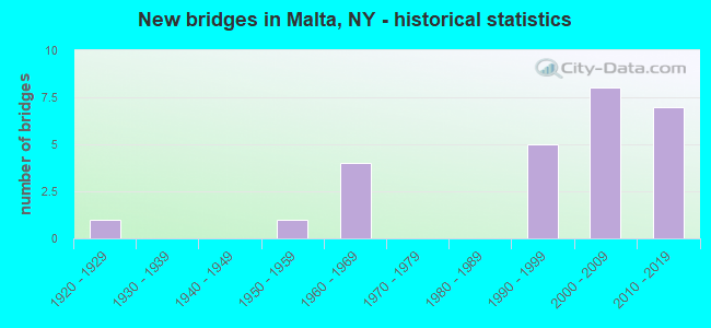
- New bridges - historical statistics
- 11920-1929
- 11950-1959
- 41960-1969
- 51990-1999
- 82000-2009
- 72010-2019
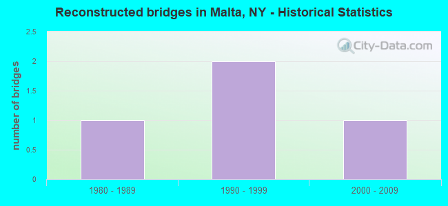
- Reconstructed bridges - Historical Statistics
- 11980-1989
- 21990-1999
- 12000-2009
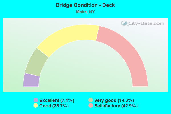
- Bridge Condition - Deck
- 7.1%Excellent
- 14.3%Very good
- 35.7%Good
- 42.9%Satisfactory
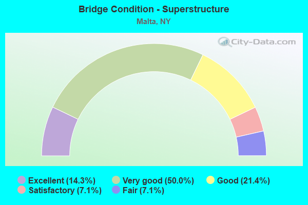
- Bridge Condition - Superstructure
- 14.3%Excellent
- 50.0%Very good
- 21.4%Good
- 7.1%Satisfactory
- 7.1%Fair
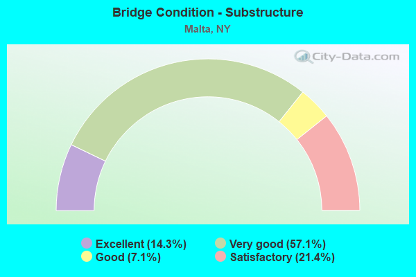
- Bridge Condition - Substructure
- 14.3%Excellent
- 57.1%Very good
- 7.1%Good
- 21.4%Satisfactory
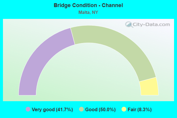
- Bridge Condition - Channel
- 41.7%Very good
- 50.0%Good
- 8.3%Fair
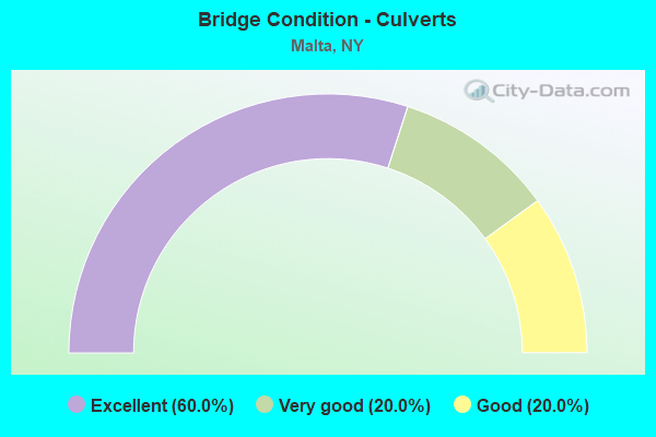
- Bridge Condition - Culverts
- 60.0%Excellent
- 20.0%Very good
- 20.0%Good
Find on map >> Show street view
Structure Number: 100562, Location: SH 9 IN ROUND LAKE (Lat: 42.940147, Lng: -73.789442), Route carried "on" structure: US 9, Year Built: 1960, Status: Open, Structure Length: 0.98m (3.22ft), Average Daily Traffic: 5,702 (year 2017), Truck Traffic: 5%, Average Future Daily Traffic: 5,728 (year 2040), Features Intersected: BALLSTON CREEK
Minimum Vertical Clearance: 30+ m (98+ ft), Kilometerpoint: 14.819, Lanes on structure: 4, Base Highway Network: Yes, Owner: State Highway Agency, Approaching Roadway Width: 21.9m (71.9ft), Skew: 23 degrees, Material/Design: Concrete continuous, Design/Construction: Frame, Number Of Spans In Main Unit: 2, Length of Maximum Span: 4.6m (15.1ft), Curb-To-Curb Width: 21.9m (71.9ft), Out-to-Out Width: 32.3m (106.0ft)
Condition: Deck: Satisfactory, Superstructure: Satisfactory, Substructure: Satisfactory, Channel: Fair, Operating Rating: 58.1 metric tons, Method Used To Determine Operating Rating: Load Factor (LF), Inventory Rating: 34.5 metric tons, Method Used To Determine Inventory Rating: Load Factor (LF), Structural Evaluation: Equal to present minimum criteria, Deck Geometry: Superior to present desirable criteria, Waterway Adequacy: Superior to present desirable criteria, Approach Roadway Alignment: Equal to present desirable criteria, Length Of Structure Improvement: 0.97m (3.18ft), Designated Inspection Frequency: Every 24 months, Inspection Date: August 2020, Bridge Improvement Cost: $1,357,000, Roadway Improvement Cost: $795,000, Total Project Cost: $2,152,000 ( Estimate for 2021), Wearing Surface/Protective System: Wearing Surface: Bituminous
Find on map >> Show street view
Structure Number: 1005639, Location: JCT.RTE 9 & 87I (Lat: 43.021489, Lng: -73.791411), Route carried "on" structure: US 9, Year Built: 1962, Year Reconstructed: 2003, Status: Open, Structure Length: 10.03m (32.91ft), Average Daily Traffic: 15,152 (year 2017), Truck Traffic: 6%, Average Future Daily Traffic: 15,223 (year 2040), Design Load: HS 25 or greater, Features Intersected: 87I 87I15091165 NB, RTE
Minimum Vertical Clearance: 30+ m (98+ ft), Kilometerpoint: 24.022, Lanes on structure: 6, Lanes under structure: 12, Base Highway Network: Yes, Owner: State Highway Agency, Approaching Roadway Width: 29.3m (96.1ft), Skew: 23 degrees, Material/Design: Steel continuous, Design/Construction: Stringer/Multi-beam, Number Of Spans In Main Unit: 4, Length of Maximum Span: 27.4m (89.9ft), Curb or Sidewalk Widths: Left: 0.5m (1.6ft), Right: 0.5m (1.6ft), Curb-To-Curb Width: 29.3m (96.1ft), Out-to-Out Width: 30.9m (101.4ft)
Condition: Deck: Satisfactory, Superstructure: Good, Substructure: Satisfactory, Operating Rating: 59.0 metric tons, Method Used To Determine Operating Rating: Load Factor (LF), Inventory Rating: 35.4 metric tons, Method Used To Determine Inventory Rating: Load Factor (LF), Structural Evaluation: Equal to present minimum criteria, Deck Geometry: Superior to present desirable criteria, Underclear: High priority of corrective action, Approach Roadway Alignment: Equal to present desirable criteria, Length Of Structure Improvement: 10.02m (32.87ft), Designated Inspection Frequency: Every 24 months, Inspection Date: May 2020, Bridge Improvement Cost: $6,696,000, Roadway Improvement Cost: $3,921,000, Total Project Cost: $10,617,000 ( Estimate for 2021), Deck Structure Type: Concrete Cast-file-Place, Wearing Surface/Protective System: Wearing Surface: Bituminous
Find on map >> Show street view
Structure Number: 1005641, Location: .2 MILE N EXIT 13 OF I87 (Lat: 43.031297, Lng: -73.790547), Route carried "on" structure: US 9, Year Built: 2016, Status: Open, Structure Length: 4.05m (13.29ft), Average Daily Traffic: 8,506 (year 2017), Truck Traffic: 10%, Average Future Daily Traffic: 8,545 (year 2040), Design Load: HL 93, Features Intersected: KAYADEROSSERAS CREEK
Minimum Vertical Clearance: 30+ m (98+ ft), Kilometerpoint: 25.245, Lanes on structure: 2, Base Highway Network: Yes, Owner: State Highway Agency, Approaching Roadway Width: 11.6m (38.1ft), Skew: 4 degrees, Material/Design: Prestressed concrete, Design/Construction: Stringer/Multi-beam, Number Of Spans In Main Unit: 1, Length of Maximum Span: 39.6m (129.9ft), Curb-To-Curb Width: 11.6m (38.1ft), Out-to-Out Width: 12.6m (41.3ft)
Condition: Deck: Good, Superstructure: Excellent, Substructure: Excellent, Channel: Good, Inventory Rating: 42.6 metric tons, Method Used To Determine Inventory Rating: Load Factor (LF), Structural Evaluation: Superior to present desirable criteria, Deck Geometry: Better than present minimum criteria, Waterway Adequacy: Superior to present desirable criteria, Approach Roadway Alignment: Equal to present desirable criteria, Length Of Structure Improvement: 4.05m (13.29ft), Designated Inspection Frequency: Every 24 months, Inspection Date: June 2020, Bridge Improvement Cost: $1,699,000, Roadway Improvement Cost: $995,000, Total Project Cost: $2,694,000 ( Estimate for 2021), Deck Structure Type: Concrete Cast-file-Place, Wearing Surface/Protective System: Wearing Surface: Integral Concrete, Deck Protection: Epoxy Coated Reinforcing
Find on map >> Show street view
Structure Number: 1005642, Location: .2 MI N OF EXIT 13 OF I87 (Lat: 43.031578, Lng: -73.789814), Route carried "on" structure: US 9, Year Built: 1928, Year Reconstructed: 1993, Status: Open, Structure Length: 2.90m (9.51ft), Average Daily Traffic: 8,506 (year 2017), Truck Traffic: 10%, Average Future Daily Traffic: 8,545 (year 2040), Design Load: HS 20, Features Intersected: KAYADEROSSERAS CK
Minimum Vertical Clearance: 30+ m (98+ ft), Kilometerpoint: 25.245, Lanes on structure: 2, Base Highway Network: Yes, Owner: State Highway Agency, Approaching Roadway Width: 11.0m (36.1ft), Skew: 4 degrees, Material/Design: Steel, Design/Construction: Stringer/Multi-beam, Number Of Spans In Main Unit: 1, Length of Maximum Span: 27.4m (89.9ft), Curb-To-Curb Width: 11.0m (36.1ft), Out-to-Out Width: 11.6m (38.1ft)
Condition: Deck: Satisfactory, Superstructure: Very good, Substructure: Good, Channel: Good, Operating Rating: 75.3 metric tons, Method Used To Determine Operating Rating: Load Factor (LF), Inventory Rating: 41.7 metric tons, Method Used To Determine Inventory Rating: Load Factor (LF), Structural Evaluation: Better than present minimum criteria, Deck Geometry: Equal to present minimum criteria, Waterway Adequacy: Superior to present desirable criteria, Approach Roadway Alignment: Equal to present desirable criteria, Length Of Structure Improvement: 2.89m (9.48ft), Designated Inspection Frequency: Every 24 months, Inspection Date: July 2021, Bridge Improvement Cost: $1,229,000, Roadway Improvement Cost: $720,000, Total Project Cost: $1,949,000 ( Estimate for 2021), Deck Structure Type: Concrete Cast-file-Place, Wearing Surface/Protective System: Wearing Surface: Integral Concrete, Deck Protection: Epoxy Coated Reinforcing
Find on map >> Show street view
Structure Number: 102919, Location: JCT RTE 67 & I87 (Lat: 42.970383, Lng: -73.802136), Route carried "on" structure: State highway 67, Year Built: 2006, Status: Open, Structure Length: 8.35m (27.40ft), Average Daily Traffic: 17,235 (year 2020), Truck Traffic: 7%, Average Future Daily Traffic: 17,316 (year 2040), Design Load: HL 93, Features Intersected: 87I 87I15091127 NB, RTE
Minimum Vertical Clearance: 30+ m (98+ ft), Kilometerpoint: 28.109, Lanes on structure: 4, Lanes under structure: 6, Base Highway Network: Yes, Owner: State Highway Agency, Approaching Roadway Width: 22.3m (73.2ft), Skew: 20 degrees, Material/Design: Steel continuous, Design/Construction: Stringer/Multi-beam, Number Of Spans In Main Unit: 2, Length of Maximum Span: 41.1m (134.8ft), Curb or Sidewalk Widths: Left: 3.0m (9.8ft), Right: 3.0m (9.8ft), Curb-To-Curb Width: 15.6m (51.2ft), Out-to-Out Width: 22.9m (75.1ft)
Condition: Deck: Good, Superstructure: Very good, Substructure: Very good, Operating Rating: 83.5 metric tons, Method Used To Determine Operating Rating: Load Factor (LF), Inventory Rating: 49.9 metric tons, Method Used To Determine Inventory Rating: Load Factor (LF), Structural Evaluation: Equal to present desirable criteria, Deck Geometry: Meets minimum limits, Underclear: Meets minimum limits, Approach Roadway Alignment: Equal to present desirable criteria, Length Of Structure Improvement: 8.35m (27.40ft), Designated Inspection Frequency: Every 24 months, Inspection Date: March 2020, Bridge Improvement Cost: $4,209,000, Roadway Improvement Cost: $2,465,000, Total Project Cost: $6,674,000 ( Estimate for 2021), Deck Structure Type: Concrete Cast-file-Place, Wearing Surface/Protective System: Wearing Surface: Monolithic Concrete, Deck Protection: Epoxy Coated Reinforcing
Find on map >> Show street view
Structure Number: 1033281, Location: 1.3 MI S JCT I87 & SH 67 (Lat: 42.951183, Lng: -73.804083), Route carried "on" structure: Interstate 87, Year Built: 1996, Status: Open, Structure Length: 3.78m (12.40ft), Average Daily Traffic: 38,860 (year 2014), Truck Traffic: 10%, Design Load: HS 25 or greater, Features Intersected: ZIM SMITH TRAIL
Minimum Vertical Clearance: 30+ m (98+ ft), Kilometerpoint: 18.327, Lanes on structure: 3, Base Highway Network: Yes, Owner: State Highway Agency, Approaching Roadway Width: 18.9m (62.0ft), Skew: 1 degrees, Material/Design: Steel, Design/Construction: Stringer/Multi-beam, Number Of Spans In Main Unit: 1, Length of Maximum Span: 36.5m (119.8ft), Curb-To-Curb Width: 19.0m (62.3ft), Out-to-Out Width: 20.0m (65.6ft)
Condition: Deck: Good, Superstructure: Good, Substructure: Very good, Operating Rating: 75.3 metric tons, Method Used To Determine Operating Rating: Load Factor (LF), Inventory Rating: 45.4 metric tons, Method Used To Determine Inventory Rating: Load Factor (LF), Structural Evaluation: Better than present minimum criteria, Deck Geometry: Superior to present desirable criteria, Approach Roadway Alignment: Equal to present desirable criteria, Length Of Structure Improvement: 3.77m (12.37ft), Designated Inspection Frequency: Every 24 months, Inspection Date: April 2020, Bridge Improvement Cost: $1,895,000, Roadway Improvement Cost: $1,110,000, Total Project Cost: $3,005,000 ( Estimate for 2021), Deck Structure Type: Concrete Cast-file-Place, Wearing Surface/Protective System: Wearing Surface: Integral Concrete, Deck Protection: Epoxy Coated Reinforcing
Find on map >> Show street view
Structure Number: 1033282, Location: 1.3 MI S JCT I87 & SH 67 (Lat: 42.951092, Lng: -73.803850), Route carried "on" structure: Interstate 87, Year Built: 1996, Status: Open, Structure Length: 3.78m (12.40ft), Average Daily Traffic: 27,361 (year 2015), Truck Traffic: 10%, Average Future Daily Traffic: 43,359 (year 2040), Design Load: HS 25 or greater, Features Intersected: ZIM SMITH TRAIL
Minimum Vertical Clearance: 30+ m (98+ ft), Kilometerpoint: 18.327, Lanes on structure: 3, Base Highway Network: Yes, Owner: State Highway Agency, Approaching Roadway Width: 18.9m (62.0ft), Skew: 1 degrees, Material/Design: Steel, Design/Construction: Stringer/Multi-beam, Number Of Spans In Main Unit: 1, Length of Maximum Span: 36.5m (119.8ft), Curb-To-Curb Width: 19.0m (62.3ft), Out-to-Out Width: 20.0m (65.6ft)
Condition: Deck: Good, Superstructure: Good, Substructure: Very good, Operating Rating: 75.3 metric tons, Method Used To Determine Operating Rating: Load Factor (LF), Inventory Rating: 45.4 metric tons, Method Used To Determine Inventory Rating: Load Factor (LF), Structural Evaluation: Better than present minimum criteria, Deck Geometry: Superior to present desirable criteria, Approach Roadway Alignment: Equal to present desirable criteria, Length Of Structure Improvement: 3.77m (12.37ft), Designated Inspection Frequency: Every 24 months, Inspection Date: April 2020, Bridge Improvement Cost: $1,943,000, Roadway Improvement Cost: $1,138,000, Total Project Cost: $3,081,000 ( Estimate for 2021), Deck Structure Type: Concrete Cast-file-Place, Wearing Surface/Protective System: Wearing Surface: Integral Concrete, Deck Protection: Epoxy Coated Reinforcing
Find on map >> Show street view
Structure Number: 103329, Location: 1.1 MI S JCT I87 & RT 67 (Lat: 42.952961, Lng: -73.803167), Route carried "on" structure: Interstate 87, Year Built: 1959, Year Reconstructed: 2000, Status: Open, Structure Length: 1.22m (4.00ft), Average Daily Traffic: 54,722 (year 2015), Truck Traffic: 10%, Average Future Daily Traffic: 86,717 (year 2040), Design Load: H 20, Features Intersected: BALLSTON CREEK
Minimum Vertical Clearance: 30+ m (98+ ft), Kilometerpoint: 18.552, Lanes on structure: 6, Base Highway Network: Yes, Owner: State Highway Agency, Approaching Roadway Width: 31.7m (104.0ft), Skew: 24 degrees, Material/Design: Steel, Design/Construction: Culvert, Number Of Spans In Main Unit: 3, Length of Maximum Span: 3.6m (11.8ft)
Condition: Channel: Good, Culverts: Good, Operating Rating: 72.5 metric tons, Method Used To Determine Operating Rating: Field evaluation and documented engineering judgment, Inventory Rating: 32.7 metric tons, Method Used To Determine Inventory Rating: Field evaluation and documented engineering judgment, Structural Evaluation: Better than present minimum criteria, Waterway Adequacy: Superior to present desirable criteria, Approach Roadway Alignment: Equal to present desirable criteria, Length Of Structure Improvement: 1.21m (3.97ft), Designated Inspection Frequency: Every 24 months, Inspection Date: July 2021, Bridge Improvement Cost: $681,000, Roadway Improvement Cost: $399,000, Total Project Cost: $1,080,000 ( Estimate for 2021)
Find on map >> Show street view
Structure Number: 10333, Location: 1.7 MI N JCT I87 & SH 67 (Lat: 42.995567, Lng: -73.803281), Route carried "on" structure: Other road , Year Built: 2018, Status: Open, Structure Length: 9.20m (30.18ft), Average Daily Traffic: 2,611 (year 2020), Truck Traffic: 4%, Average Future Daily Traffic: 3,655 (year 2040), Design Load: HL 93, Features Intersected: 87I 87I15091145, RTE I87, Facility Carried by Structure: EAST HIGH STREET
Minimum Vertical Clearance: 30+ m (98+ ft), Kilometerpoint: 1.207, Lanes on structure: 2, Lanes under structure: 6, Owner: State Highway Agency, Approaching Roadway Width: 10.1m (33.1ft), Skew: 1 degrees, Material/Design: Steel, Design/Construction: Stringer/Multi-beam, Number Of Spans In Main Unit: 2, Length of Maximum Span: 45.7m (149.9ft), Curb-To-Curb Width: 9.8m (32.2ft), Out-to-Out Width: 11.0m (36.1ft)
Condition: Deck: Excellent, Superstructure: Excellent, Substructure: Excellent, Operating Rating: 72.6 metric tons, Method Used To Determine Operating Rating: Load Factor (LF), Inventory Rating: 42.6 metric tons, Method Used To Determine Inventory Rating: Load Factor (LF), Structural Evaluation: Superior to present desirable criteria, Deck Geometry: Meets minimum limits, Underclear: High priority of corrective action, Approach Roadway Alignment: Equal to present desirable criteria, Length Of Structure Improvement: 9.20m (30.18ft), Designated Inspection Frequency: Every 24 months, Inspection Date: October 2020, Bridge Improvement Cost: $2,576,000, Roadway Improvement Cost: $1,509,000, Total Project Cost: $4,085,000 ( Estimate for 2021), Deck Structure Type: Concrete Cast-file-Place, Wearing Surface/Protective System: Wearing Surface: Integral Concrete, Deck Protection: Epoxy Coated Reinforcing
Find on map >> Show street view
Structure Number: 103331, Location: JCT I87 & MALTA AVE LT (Lat: 43.013717, Lng: -73.799481), Route carried "on" structure: County highway , Year Built: 2010, Status: Open, Structure Length: 3.14m (10.30ft), Average Daily Traffic: 7,515 (year 2017), Truck Traffic: 5%, Average Future Daily Traffic: 9,298 (year 2040), Design Load: HL 93, Features Intersected: RTE I87, Facility Carried by Structure: MALTA AVE C.R.63
Minimum Vertical Clearance: 30+ m (98+ ft), Kilometerpoint: 3.749, Lanes on structure: 2, Lanes under structure: 3, Owner: State Highway Agency, Approaching Roadway Width: 9.1m (29.9ft), Material/Design: Steel, Design/Construction: Stringer/Multi-beam, Number Of Spans In Main Unit: 1, Length of Maximum Span: 29.9m (98.1ft), Curb or Sidewalk Widths: Left: 0.0m, Right: 1.5m (4.9ft), Curb-To-Curb Width: 9.1m (29.9ft), Out-to-Out Width: 12.1m (39.7ft)
Condition: Deck: Very good, Superstructure: Very good, Substructure: Very good, Inventory Rating: 70.8 metric tons, Method Used To Determine Inventory Rating: Load Factor (LF), Structural Evaluation: Equal to present desirable criteria, Deck Geometry: High priority of corrective action, Underclear: Somewhat better than minimum adequacy, Approach Roadway Alignment: Equal to present desirable criteria, Length Of Structure Improvement: 3.13m (10.27ft), Designated Inspection Frequency: Every 24 months, Inspection Date: May 2020, Bridge Improvement Cost: $1,263,000, Roadway Improvement Cost: $740,000, Total Project Cost: $2,003,000 ( Estimate for 2021), Deck Structure Type: Concrete Cast-file-Place, Wearing Surface/Protective System: Wearing Surface: Integral Concrete, Deck Protection: Epoxy Coated Reinforcing
Find on map >> Show street view
Structure Number: 1033321, Location: I87 & KAYADEROSSERAS CRK (Lat: 43.042175, Lng: -73.775858), Route carried "on" structure: Interstate 87, Year Built: 1998, Status: Open, Structure Length: 4.69m (15.39ft), Average Daily Traffic: 31,221 (year 2006), Truck Traffic: 9%, Average Future Daily Traffic: 43,709 (year 2026), Design Load: HS 25 or greater, Features Intersected: KAYADEROSSERAS CK
Minimum Vertical Clearance: 30+ m (98+ ft), Kilometerpoint: 29.042, Lanes on structure: 3, Base Highway Network: Yes, Owner: State Highway Agency, Approaching Roadway Width: 15.8m (51.8ft), Skew: 1 degrees, Material/Design: Steel, Design/Construction: Stringer/Multi-beam, Number Of Spans In Main Unit: 1, Length of Maximum Span: 46.3m (151.9ft), Curb-To-Curb Width: 15.8m (51.8ft), Out-to-Out Width: 16.5m (54.1ft)
Condition: Deck: Satisfactory, Superstructure: Very good, Substructure: Very good, Channel: Good, Operating Rating: 79.8 metric tons, Method Used To Determine Operating Rating: Load Factor (LF), Inventory Rating: 48.1 metric tons, Method Used To Determine Inventory Rating: Load Factor (LF), Structural Evaluation: Equal to present desirable criteria, Deck Geometry: Somewhat better than minimum adequacy, Waterway Adequacy: Superior to present desirable criteria, Approach Roadway Alignment: Equal to present desirable criteria, Length Of Structure Improvement: 4.69m (15.39ft), Designated Inspection Frequency: Every 24 months, Inspection Date: April 2020, Bridge Improvement Cost: $1,749,000, Roadway Improvement Cost: $1,024,000, Total Project Cost: $2,773,000 ( Estimate for 2021), Deck Structure Type: Concrete Cast-file-Place, Wearing Surface/Protective System: Wearing Surface: Integral Concrete, Deck Protection: Epoxy Coated Reinforcing
Find on map >> Show street view
Structure Number: 1033322, Location: I87 & KAYADEROSSERAS CRK (Lat: 43.041994, Lng: -73.774856), Route carried "on" structure: Interstate 87, Year Built: 1998, Status: Open, Structure Length: 4.69m (15.39ft), Average Daily Traffic: 23,725 (year 2016), Truck Traffic: 18%, Average Future Daily Traffic: 37,597 (year 2040), Design Load: HS 25 or greater, Features Intersected: KAYADEROSSERAS CK
Minimum Vertical Clearance: 30+ m (98+ ft), Kilometerpoint: 29.059, Lanes on structure: 3, Base Highway Network: Yes, Owner: State Highway Agency, Approaching Roadway Width: 15.8m (51.8ft), Skew: 1 degrees, Material/Design: Steel, Design/Construction: Stringer/Multi-beam, Number Of Spans In Main Unit: 1, Length of Maximum Span: 46.3m (151.9ft), Curb-To-Curb Width: 15.8m (51.8ft), Out-to-Out Width: 16.5m (54.1ft)
Condition: Deck: Satisfactory, Superstructure: Very good, Substructure: Very good, Channel: Good, Operating Rating: 79.8 metric tons, Method Used To Determine Operating Rating: Load Factor (LF), Inventory Rating: 48.1 metric tons, Method Used To Determine Inventory Rating: Load Factor (LF), Structural Evaluation: Equal to present desirable criteria, Deck Geometry: Somewhat better than minimum adequacy, Waterway Adequacy: Superior to present desirable criteria, Approach Roadway Alignment: Equal to present desirable criteria, Length Of Structure Improvement: 4.69m (15.39ft), Designated Inspection Frequency: Every 24 months, Inspection Date: April 2020, Bridge Improvement Cost: $1,749,000, Roadway Improvement Cost: $1,024,000, Total Project Cost: $2,773,000 ( Estimate for 2021), Deck Structure Type: Concrete Cast-file-Place, Wearing Surface/Protective System: Wearing Surface: Integral Concrete, Deck Protection: Epoxy Coated Reinforcing
Find on map >> Show street view
Structure Number: 107893, Location: 0.3 mi. W of Rte.9/Rte.67 (Lat: 42.948986, Lng: -73.797869), Route carried "on" structure: Bypass State highway 915J, Year Built: 2008, Status: Open, Structure Length: 19.60m (64.30ft), Average Daily Traffic: 4,834 (year 2014), Truck Traffic: 7%, Average Future Daily Traffic: 6,768 (year 2034), Design Load: HS 25 or greater, Features Intersected: Vacant land, RTE 915, MA
Minimum Vertical Clearance: 30+ m (98+ ft), Kilometerpoint: 2.140, Lanes on structure: 2, Base Highway Network: Yes, Owner: State Highway Agency, Approaching Roadway Width: 11.9m (39.0ft), Material/Design: Steel continuous, Design/Construction: Stringer/Multi-beam, Number Of Spans In Main Unit: 4, Length of Maximum Span: 53.9m (176.8ft), Curb-To-Curb Width: 12.0m (39.4ft), Out-to-Out Width: 13.0m (42.7ft)
Condition: Deck: Good, Superstructure: Very good, Substructure: Very good, Channel: Very good, Operating Rating: 50.8 metric tons, Method Used To Determine Operating Rating: Load Factor (LF), Inventory Rating: 29.9 metric tons, Method Used To Determine Inventory Rating: Load Factor (LF), Structural Evaluation: Better than present minimum criteria, Deck Geometry: Somewhat better than minimum adequacy, Waterway Adequacy: Superior to present desirable criteria, Approach Roadway Alignment: Equal to present desirable criteria, Length Of Structure Improvement: 19.59m (64.27ft), Designated Inspection Frequency: Every 24 months, Inspection Date: June 2020, Bridge Improvement Cost: $5,356,000, Roadway Improvement Cost: $3,136,000, Total Project Cost: $8,492,000 ( Estimate for 2021), Deck Structure Type: Concrete Cast-file-Place, Wearing Surface/Protective System: Wearing Surface: Integral Concrete, Deck Protection: Epoxy Coated Reinforcing
Find on map >> Show street view
Structure Number: 109583, Location: IN MALTA RIDGE (Lat: 43.013500, Lng: -73.798775), Route carried "on" structure: County highway , Year Built: 2010, Status: Open, Structure Length: 3.14m (10.30ft), Average Daily Traffic: 7,515 (year 2017), Truck Traffic: 5%, Average Future Daily Traffic: 9,298 (year 2040), Design Load: HL 93, Features Intersected: RTE I87, Facility Carried by Structure: MALTA AVENUE
Minimum Vertical Clearance: 30+ m (98+ ft), Kilometerpoint: 3.797, Lanes on structure: 2, Lanes under structure: 3, Owner: State Highway Agency, Approaching Roadway Width: 9.1m (29.9ft), Material/Design: Steel, Design/Construction: Stringer/Multi-beam, Number Of Spans In Main Unit: 1, Length of Maximum Span: 29.9m (98.1ft), Curb or Sidewalk Widths: Left: 0.0m, Right: 1.5m (4.9ft), Curb-To-Curb Width: 9.1m (29.9ft), Out-to-Out Width: 12.1m (39.7ft)
Condition: Deck: Very good, Superstructure: Very good, Substructure: Very good, Inventory Rating: 70.8 metric tons, Method Used To Determine Inventory Rating: Load Factor (LF), Structural Evaluation: Equal to present desirable criteria, Deck Geometry: High priority of corrective action, Underclear: Meets minimum limits, Approach Roadway Alignment: Equal to present desirable criteria, Length Of Structure Improvement: 3.13m (10.27ft), Designated Inspection Frequency: Every 24 months, Inspection Date: May 2020, Bridge Improvement Cost: $1,292,000, Roadway Improvement Cost: $756,000, Total Project Cost: $2,048,000 ( Estimate for 2021), Deck Structure Type: Concrete Cast-file-Place, Wearing Surface/Protective System: Wearing Surface: Integral Concrete, Deck Protection: Epoxy Coated Reinforcing
Find on map >> Show street view
Structure Number: 227056, Location: .7m E Route 9 (Lat: 42.959700, Lng: -73.778019), Route carried "on" structure: ServiceCounty highway , Year Built: 2009, Status: Open, Structure Length: 1.49m (4.89ft), Average Daily Traffic: 2,076 (year 2019), Truck Traffic: 5%, Average Future Daily Traffic: 2,906 (year 2039), Design Load: HS 25 or greater, Features Intersected: UNKNOWN CREEK, Facility Carried by Structure: CR 77, STONEBREAK
Minimum Vertical Clearance: 30+ m (98+ ft), Kilometerpoint: 1.191, Lanes on structure: 2, Owner: County Highway Agency, Approaching Roadway Width: 11.6m (38.1ft), Skew: 1 degrees, Material/Design: Concrete, Design/Construction: Culvert, Number Of Spans In Main Unit: 1, Length of Maximum Span: 14.6m (47.9ft), Curb or Sidewalk Widths: Left: 3.0m (9.8ft), Right: 0.0m
Condition: Channel: Very good, Culverts: Excellent, Operating Rating: 94.3 metric tons, Method Used To Determine Operating Rating: Load Factor (LF), Inventory Rating: 56.2 metric tons, Method Used To Determine Inventory Rating: Load Factor (LF), Structural Evaluation: Superior to present desirable criteria, Waterway Adequacy: Superior to present desirable criteria, Approach Roadway Alignment: Equal to present desirable criteria, Length Of Structure Improvement: 1.49m (4.89ft), Designated Inspection Frequency: Every 24 months, Inspection Date: July 2020, Bridge Improvement Cost: $330,000, Roadway Improvement Cost: $193,000, Total Project Cost: $524,000 ( Estimate for 2021), Wearing Surface/Protective System: Wearing Surface: Bituminous
Find on map >> Show street view
Structure Number: 227057, Location: .5m N Route 67 (Lat: 42.954303, Lng: -73.776892), Route carried "on" structure: ServiceCounty highway , Year Built: 2009, Status: Open, Structure Length: 1.13m (3.71ft), Average Daily Traffic: 3,644 (year 2014), Truck Traffic: 5%, Average Future Daily Traffic: 5,102 (year 2034), Design Load: HS 25 or greater, Features Intersected: UNKNOWN CREEK, Facility Carried by Structure: CR 78, LUTHER FORE
Minimum Vertical Clearance: 30+ m (98+ ft), Kilometerpoint: 1.158, Lanes on structure: 5, Owner: County Highway Agency, Approaching Roadway Width: 22.9m (75.1ft), Skew: 4 degrees, Material/Design: Concrete, Design/Construction: Culvert, Number Of Spans In Main Unit: 1, Length of Maximum Span: 11.0m (36.1ft), Curb or Sidewalk Widths: Left: 0.0m, Right: 3.0m (9.8ft)
Condition: Channel: Very good, Culverts: Excellent, Operating Rating: 81.6 metric tons, Method Used To Determine Operating Rating: Load Factor (LF), Inventory Rating: 49.0 metric tons, Method Used To Determine Inventory Rating: Load Factor (LF), Structural Evaluation: Superior to present desirable criteria, Waterway Adequacy: Superior to present desirable criteria, Approach Roadway Alignment: Equal to present desirable criteria, Length Of Structure Improvement: 1.12m (3.67ft), Designated Inspection Frequency: Every 24 months, Inspection Date: July 2020, Bridge Improvement Cost: $968,000, Roadway Improvement Cost: $567,000, Total Project Cost: $1,535,000 ( Estimate for 2021), Wearing Surface/Protective System: Wearing Surface: Bituminous
Find on map >> Show street view
Structure Number: 227058, Location: .5m N Route 67 (Lat: 42.954764, Lng: -73.775425), Route carried "on" structure: ServiceCounty highway , Year Built: 2009, Status: Open, Structure Length: 1.13m (3.71ft), Average Daily Traffic: 3,644 (year 2014), Truck Traffic: 5%, Average Future Daily Traffic: 5,102 (year 2034), Design Load: HS 25 or greater, Features Intersected: UNKNOWN CREEK, Facility Carried by Structure: CR 78, LUTHER FORE
Minimum Vertical Clearance: 30+ m (98+ ft), Kilometerpoint: 1.239, Lanes on structure: 5, Owner: County Highway Agency, Approaching Roadway Width: 22.6m (74.1ft), Skew: 3 degrees, Material/Design: Concrete, Design/Construction: Culvert, Number Of Spans In Main Unit: 1, Length of Maximum Span: 11.0m (36.1ft), Curb or Sidewalk Widths: Left: 3.0m (9.8ft), Right: 3.0m (9.8ft)
Condition: Channel: Very good, Culverts: Excellent, Operating Rating: 81.6 metric tons, Method Used To Determine Operating Rating: Load Factor (LF), Inventory Rating: 49.0 metric tons, Method Used To Determine Inventory Rating: Load Factor (LF), Structural Evaluation: Superior to present desirable criteria, Waterway Adequacy: Superior to present desirable criteria, Approach Roadway Alignment: Equal to present desirable criteria, Length Of Structure Improvement: 1.12m (3.67ft), Designated Inspection Frequency: Every 24 months, Inspection Date: July 2020, Bridge Improvement Cost: $873,000, Roadway Improvement Cost: $511,000, Total Project Cost: $1,384,000 ( Estimate for 2021), Wearing Surface/Protective System: Wearing Surface: Bituminous
Find on map >> Show street view
Structure Number: 330437, Location: 2 M W OF I87-EXIT 12 (Lat: 42.969825, Lng: -73.830739), Route carried "on" structure: County highway , Year Built: 2001, Status: Open, Structure Length: 0.82m (2.69ft), Average Daily Traffic: 4,138 (year 2018), Truck Traffic: 5%, Average Future Daily Traffic: 6,019 (year 2040), Design Load: HS 25 or greater, Features Intersected: BALLSTON CREEK, Facility Carried by Structure: EASTLINE ROAD
Minimum Vertical Clearance: 30+ m (98+ ft), Kilometerpoint: 5.229, Lanes on structure: 2, Owner: County Highway Agency, Approaching Roadway Width: 8.5m (27.9ft), Material/Design: Aluminum, Iron, Design/Construction: Culvert, Number Of Spans In Main Unit: 1, Length of Maximum Span: 6.7m (22.0ft), Curb-To-Curb Width: 8.7m (28.5ft), Out-to-Out Width: 9.9m (32.5ft)
Condition: Channel: Very good, Culverts: Very good, Operating Rating: 74.4 metric tons, Method Used To Determine Operating Rating: Load Factor (LF), Inventory Rating: 49.0 metric tons, Method Used To Determine Inventory Rating: Load Factor (LF), Structural Evaluation: Equal to present desirable criteria, Deck Geometry: Meets minimum limits, Waterway Adequacy: Somewhat better than minimum adequacy, Approach Roadway Alignment: Equal to present desirable criteria, Length Of Structure Improvement: 0.82m (2.69ft), Designated Inspection Frequency: Every 24 months, Inspection Date: April 2021, Bridge Improvement Cost: $229,000, Roadway Improvement Cost: $134,000, Total Project Cost: $363,000 ( Estimate for 2021)
Find on map >> Show street view
Structure Number: 330445, Location: 1.7 MI NE JCT I87 & US 9 (Lat: 43.043653, Lng: -73.771058), Route carried "on" structure: County highway , Year Built: 1962, Year Reconstructed: 1998, Status: Open, Structure Length: 4.15m (13.62ft), Average Daily Traffic: 459 (year 2020), Truck Traffic: 7%, Average Future Daily Traffic: 567 (year 2040), Design Load: H 20, Features Intersected: KAYADEROSSERAS CK, Facility Carried by Structure: NELSON AVE EXT
Minimum Vertical Clearance: 30+ m (98+ ft), Kilometerpoint: 3.701, Lanes on structure: 2, Owner: County Highway Agency, Approaching Roadway Width: 6.7m (22.0ft), Material/Design: Prestressed concrete, Design/Construction: Stringer/Multi-beam, Number Of Spans In Main Unit: 1, Length of Maximum Span: 40.8m (133.9ft), Curb or Sidewalk Widths: Left: 0.5m (1.6ft), Right: 0.5m (1.6ft), Curb-To-Curb Width: 6.7m (22.0ft), Out-to-Out Width: 8.3m (27.2ft)
Condition: Deck: Satisfactory, Superstructure: Fair, Substructure: Satisfactory, Channel: Good, Operating Rating: 92.1 metric tons, Method Used To Determine Operating Rating: Field evaluation and documented engineering judgment, Inventory Rating: 31.1 metric tons, Method Used To Determine Inventory Rating: Field evaluation and documented engineering judgment, Structural Evaluation: Somewhat better than minimum adequacy, Deck Geometry: Meets minimum limits, Waterway Adequacy: Superior to present desirable criteria, Approach Roadway Alignment: Equal to present minimum criteria, Length Of Structure Improvement: 4.14m (13.58ft), Designated Inspection Frequency: Every 24 months, Inspection Date: June 2020, Bridge Improvement Cost: $965,000, Roadway Improvement Cost: $565,000, Total Project Cost: $1,531,000 ( Estimate for 2021), Wearing Surface/Protective System: Wearing Surface: Bituminous, Membrane: Other
Find on map >> Show street view
Structure Number: 1005639, Location: JCT.RTE 9 & 87I (Lat: 43.021489, Lng: -73.791411), Route carried "under" structure: Interstate 87, Year Built: 1962, Structure Length: 0. m, Average Daily Traffic: 21,963 (year 2000), Features Intersected: 87I 87I15091165 NB, RTE, Facility Carried by Structure: RTE 9
Minimum Vertical Clearance: 5.69m (18.67ft), Kilometerpoint: 26.629, Lanes on structure: 6, Lanes under structure: 8, Material/Design: Steel continuous, Design/Construction: Stringer/Multi-beam, Length of Maximum Span: 27.4m (89.9ft)
Find on map >> Show street view
Structure Number: 102919, Location: JCT RTE 67 & I87 (Lat: 42.970383, Lng: -73.802136), Route carried "under" structure: Interstate 87, Year Built: 2006, Structure Length: 0. m, Average Daily Traffic: 21,963 (year 2000), Features Intersected: 87I 87I15091127 NB, RTE, Facility Carried by Structure: RTE 67
Minimum Vertical Clearance: 5.56m (18.24ft), Kilometerpoint: 20.820, Lanes on structure: 4, Lanes under structure: 3, Material/Design: Steel continuous, Design/Construction: Stringer/Multi-beam, Length of Maximum Span: 41.1m (134.8ft)
Find on map >> Show street view
Structure Number: 1033271, Location: JCT I87 & RND LAKE ROAD (Lat: 42.936917, Lng: -73.804656), Route carried "under" structure: County highway 823, Year Built: 1996, Structure Length: 0. m, Average Daily Traffic: 1,500 (year 2021), Features Intersected: RTE 823, Facility Carried by Structure: RTE I87
Minimum Vertical Clearance: 4.85m (15.91ft), Kilometerpoint: 0.000, Lanes on structure: 3, Lanes under structure: 2, Material/Design: Prestressed concrete, Design/Construction: Box Beam or Girders - Multiple, Length of Maximum Span: 22.2m (72.8ft)
Find on map >> Show street view
Structure Number: 10333, Location: 1.7 MI N JCT I87 & SH 67 (Lat: 42.995567, Lng: -73.803281), Route carried "under" structure: Interstate 87, Year Built: 2018, Structure Length: 0. m, Average Daily Traffic: 21,963 (year 2000), Features Intersected: 87I 87I15091145, RTE I87, Facility Carried by Structure: EAST HIGH STREET
Minimum Vertical Clearance: 5.89m (19.32ft), Kilometerpoint: 23.524, Lanes on structure: 2, Lanes under structure: 3, Material/Design: Steel, Design/Construction: Stringer/Multi-beam, Length of Maximum Span: 45.7m (149.9ft)
Find on map >> Show street view
Structure Number: 103331, Location: JCT I87 & MALTA AVE LT (Lat: 43.013717, Lng: -73.799481), Route carried "under" structure: Interstate 87, Year Built: 2010, Structure Length: 0. m, Average Daily Traffic: 21,963 (year 2000), Features Intersected: RTE I87, Facility Carried by Structure: MALTA AVE C.R.63
Minimum Vertical Clearance: 5.33m (17.49ft), Kilometerpoint: 25.503, Lanes on structure: 2, Lanes under structure: 3, Material/Design: Steel, Design/Construction: Stringer/Multi-beam, Length of Maximum Span: 29.9m (98.1ft)
Find on map >> Show street view
Structure Number: 107894, Location: .7 Mi. N I-87 Exit 11 (Lat: 42.949164, Lng: -73.800742), Route carried "under" structure: Bypass State highway 915, Year Built: 2008, Structure Length: 0. m, Average Daily Traffic: 4,834 (year 2014), Truck Traffic: 7%, Features Intersected: RTE 915, Facility Carried by Structure: ZIM SMITH TRAIL
Minimum Vertical Clearance: 5.28m (17.32ft), Kilometerpoint: 1.352, Lanes under structure: 2, Material/Design: Steel, Design/Construction: Truss - Thru, Length of Maximum Span: 31.1m (102.0ft)
Find on map >> Show street view
Structure Number: 109583, Location: IN MALTA RIDGE (Lat: 43.013500, Lng: -73.798775), Route carried "under" structure: Interstate 87, Year Built: 2010, Structure Length: 0. m, Average Daily Traffic: 21,963 (year 2000), Features Intersected: RTE I87, Facility Carried by Structure: MALTA AVENUE
Minimum Vertical Clearance: 5.33m (17.49ft), Kilometerpoint: 25.551, Lanes on structure: 2, Lanes under structure: 3, Material/Design: Steel, Design/Construction: Stringer/Multi-beam, Length of Maximum Span: 29.9m (98.1ft)