Bridge Statistics for Manchester, Maryland (MD)
Condition, Traffic, Stress, Structural Evaluation, Project Costs
- National Bridge Inventory (NBI) Statistics
- 11Number of bridges
- 49ft / 14.7mTotal length
- $305,000Total costs
- 21,896Total average daily traffic
- 1,430Total average daily truck traffic
- 29,571Total future (year 2026) average daily traffic
- National Bridge Inventory (NBI) Registered Bridges for Manchester
- No street view available for this location
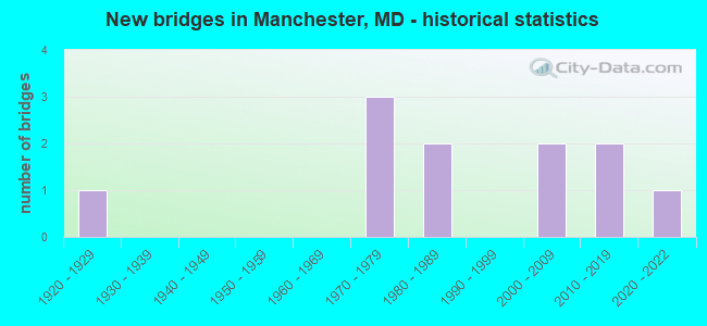
- New bridges - historical statistics
- 11920-1929
- 31970-1979
- 21980-1989
- 22000-2009
- 22010-2019
- 12020-2022

- Bridge Condition - Deck
- 50.0%Very good
- 25.0%Good
- 25.0%Fair
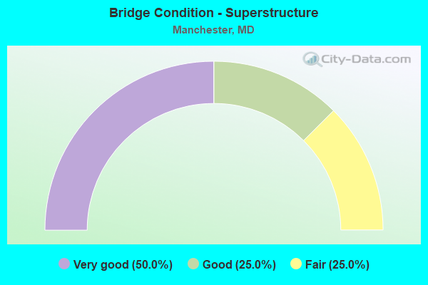
- Bridge Condition - Superstructure
- 50.0%Very good
- 25.0%Good
- 25.0%Fair
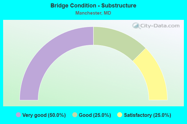
- Bridge Condition - Substructure
- 50.0%Very good
- 25.0%Good
- 25.0%Satisfactory
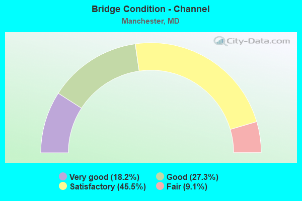
- Bridge Condition - Channel
- 18.2%Very good
- 27.3%Good
- 45.5%Satisfactory
- 9.1%Fair
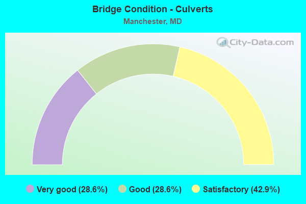
- Bridge Condition - Culverts
- 28.6%Very good
- 28.6%Good
- 42.9%Satisfactory
Find on map >> Show street view
Structure Number: 10000006001801, Location: 0.24 MI S OF PA LINE (Lat: 39.718364, Lng: -76.844906), Route carried "on" structure: State highway 86, Year Built: 1929, Status: Posted for load, Structure Length: 0.73m (2.40ft), Average Daily Traffic: 3,322 (year 2009), Truck Traffic: 8%, Average Future Daily Traffic: 3,946 (year 2026), Features Intersected: BR OF GUNPOWDER FALLS
Minimum Vertical Clearance: 30+ m (98+ ft), Kilometerpoint: 6.059, Lanes on structure: 2, Owner: State Highway Agency, Approaching Roadway Width: 12.8m (42.0ft), Skew: 2 degrees, Material/Design: Concrete, Design/Construction: Slab, Number Of Spans In Main Unit: 1, Length of Maximum Span: 6.1m (20.0ft), Curb-To-Curb Width: 7.3m (24.0ft), Out-to-Out Width: 8.2m (26.9ft)
Condition: Deck: Fair, Superstructure: Fair, Substructure: Satisfactory, Channel: Satisfactory, Operating Rating: 35.8 metric tons, Method Used To Determine Operating Rating: Load Factor (LF), Inventory Rating: 21.3 metric tons, Method Used To Determine Inventory Rating: Load Factor (LF), Structural Evaluation: Somewhat better than minimum adequacy, Deck Geometry: High priority of replacement, Waterway Adequacy: Superior to present desirable criteria, Approach Roadway Alignment: Equal to present minimum criteria, Bridge Posting: Required (Relationship of Operating Rating to Maximum Legal Load: 0.1 - 9.9% below), Length Of Structure Improvement: 0.73m (2.40ft), Designated Inspection Frequency: Every 12 months, Inspection Date: September 2021, Bridge Improvement Cost: $39,000, Roadway Improvement Cost: $4,000, Total Project Cost: $43,000, Deck Structure Type: Concrete Cast-file-Place, Wearing Surface/Protective System: Wearing Surface: Monolithic Concrete
Find on map >> Show street view
Structure Number: 10000006001901, Location: 0.97 MI S OF PA LINE (Lat: 39.710575, Lng: -76.852936), Route carried "on" structure: State highway 86, Year Built: 2020, Status: Open, Structure Length: 3.47m (11.38ft), Average Daily Traffic: 4,050 (year 2014), Truck Traffic: 9%, Average Future Daily Traffic: 4,575 (year 2030), Features Intersected: SOUTH BR GUNPOWDER FALLS
Minimum Vertical Clearance: 30+ m (98+ ft), Kilometerpoint: 4.869, Lanes on structure: 2, Owner: State Highway Agency, Approaching Roadway Width: 10.4m (34.1ft), Skew: 5 degrees, Material/Design: Prestressed concrete, Design/Construction: Box Beam or Girders - Multiple, Number Of Spans In Main Unit: 2, Length of Maximum Span: 17.4m (57.1ft), Curb-To-Curb Width: 10.9m (35.8ft), Out-to-Out Width: 12.2m (40.0ft)
Condition: Deck: Very good, Superstructure: Very good, Substructure: Very good, Channel: Good, Operating Rating: 56.7 metric tons, Method Used To Determine Operating Rating: Load and Resistance Factor Rating (LRFR) rating reported by rating factor(RF) method using HL-93 loadings, Inventory Rating: 43.7 metric tons, Method Used To Determine Inventory Rating: Load and Resistance Factor Rating (LRFR) rating reported by rating factor(RF) method using HL-93 loadings, Structural Evaluation: Equal to present desirable criteria, Deck Geometry: Somewhat better than minimum adequacy, Waterway Adequacy: Equal to present minimum criteria, Approach Roadway Alignment: Equal to present desirable criteria, Length Of Structure Improvement: 1.34m (4.40ft), Designated Inspection Frequency: Every 24 months, Underwater Inspection Frequency: Every 48 months, Inspection Date: January 2021, Underwater Inspection Date: December 2019, Bridge Improvement Cost: $71,000, Roadway Improvement Cost: $7,000, Total Project Cost: $78,000, Deck Structure Type: Concrete Cast-file-Place, Wearing Surface/Protective System: Wearing Surface: Bituminous
Find on map >> Show street view
Structure Number: 10000006003801, Location: 3.52 MILEI WEST OF MD 30 (Lat: 39.660983, Lng: -76.948217), Route carried "on" structure: State highway 496, Year Built: 2018, Status: Open, Structure Length: 1.77m (5.81ft), Average Daily Traffic: 3,975 (year 2016), Truck Traffic: 7%, Average Future Daily Traffic: 5,575 (year 2036), Features Intersected: BIG PIPE CREEK
Minimum Vertical Clearance: 30+ m (98+ ft), Kilometerpoint: 5.979, Lanes on structure: 2, Owner: State Highway Agency, Approaching Roadway Width: 9.1m (29.9ft), Material/Design: Prestressed concrete, Design/Construction: Slab, Number Of Spans In Main Unit: 1, Length of Maximum Span: 16.8m (55.1ft), Curb-To-Curb Width: 12.5m (41.0ft), Out-to-Out Width: 13.7m (44.9ft)
Condition: Deck: Very good, Superstructure: Very good, Substructure: Very good, Channel: Very good, Operating Rating: 88.1 metric tons, Method Used To Determine Operating Rating: Load and Resistance Factor Rating (LRFR) rating reported by rating factor(RF) method using HL-93 loadings, Inventory Rating: 68.0 metric tons, Method Used To Determine Inventory Rating: Load and Resistance Factor Rating (LRFR) rating reported by rating factor(RF) method using HL-93 loadings, Structural Evaluation: Equal to present desirable criteria, Deck Geometry: Equal to present minimum criteria, Waterway Adequacy: Equal to present desirable criteria, Approach Roadway Alignment: Equal to present desirable criteria, Designated Inspection Frequency: Every 24 months, Inspection Date: October 2020, Deck Structure Type: Concrete Precast Panels, Wearing Surface/Protective System: Wearing Surface: Integral Concrete, Deck Protection: Epoxy Coated Reinforcing
Find on map >> Show street view
Structure Number: 10000006005903, Location: 1.74 MI S OF PA LINE (Lat: 39.703672, Lng: -76.863558), Route carried "on" structure: State highway 86, Year Built: 1972, Status: Open, Structure Length: 1.77m (5.81ft), Average Daily Traffic: 3,442 (year 2009), Truck Traffic: 8%, Average Future Daily Traffic: 4,280 (year 2026), Features Intersected: BR OF GUNPOWDER FALLS
Minimum Vertical Clearance: 30+ m (98+ ft), Kilometerpoint: 3.636, Lanes on structure: 2, Owner: State Highway Agency, Approaching Roadway Width: 9.1m (29.9ft), Skew: 3 degrees, Material/Design: Steel, Design/Construction: Culvert, Length of Maximum Span: 2.1m (6.9ft)
Condition: Channel: Fair, Culverts: Satisfactory, Operating Rating: 34.5 metric tons, Method Used To Determine Operating Rating: Allowable Stress (AS), Inventory Rating: 25.4 metric tons, Method Used To Determine Inventory Rating: Allowable Stress (AS), Structural Evaluation: Equal to present minimum criteria, Waterway Adequacy: Better than present minimum criteria, Approach Roadway Alignment: Equal to present desirable criteria, Designated Inspection Frequency: Every 24 months, Inspection Date: March 2021
Find on map >> Show street view
Structure Number: 200000CL038101, Location: 0.1 MILE EAST OF MD 30 (Lat: 39.651683, Lng: -76.877489), Route carried "on" structure: ServiceOther road , Year Built: 2009, Status: Open, Structure Length: 1.98m (6.50ft), Average Daily Traffic: 3,415 (year 2021), Average Future Daily Traffic: 5,600 (year 2041), Design Load: HS 25 or greater, Features Intersected: GEORGE'S RUN, Facility Carried by Structure: ACCESS ROAD
Minimum Vertical Clearance: 30+ m (98+ ft), Kilometerpoint: 0.000, Lanes on structure: 3, Owner: Local Agency, Maintenance Responsibility: County Highway Agency, Approaching Roadway Width: 11.0m (36.1ft), Skew: 2 degrees, Material/Design: Prestressed concrete, Design/Construction: Slab, Number Of Spans In Main Unit: 1, Length of Maximum Span: 18.6m (61.0ft), Curb or Sidewalk Widths: Left: 1.8m (5.9ft), Right: 0.0m, Curb-To-Curb Width: 10.8m (35.4ft), Out-to-Out Width: 13.4m (44.0ft)
Condition: Deck: Good, Superstructure: Good, Substructure: Good, Channel: Very good, Operating Rating: 74.8 metric tons, Method Used To Determine Operating Rating: Load Factor (LF), Inventory Rating: 36.3 metric tons, Method Used To Determine Inventory Rating: Load Factor (LF), Structural Evaluation: Better than present minimum criteria, Deck Geometry: High priority of replacement, Waterway Adequacy: Superior to present desirable criteria, Approach Roadway Alignment: Equal to present desirable criteria, Designated Inspection Frequency: Every 24 months, Inspection Date: June 2021, Deck Structure Type: Concrete Cast-file-Place, Wearing Surface/Protective System: Wearing Surface: Integral Concrete, Deck Protection: Epoxy Coated Reinforcing
Find on map >> Show street view
Structure Number: 200000CL038702, Location: INT. W/ HARVEY GUMMEL RD (Lat: 39.627250, Lng: -76.892000), Route carried "on" structure: County highway 150, Year Built: 2019, Status: Open, Structure Length: 0.62m (2.03ft), Average Daily Traffic: 1,457 (year 2021), Truck Traffic: 5%, Average Future Daily Traffic: 1,909 (year 2041), Features Intersected: UNNAMED STREAM, Facility Carried by Structure: CAPE HORN ROAD NOR
Minimum Vertical Clearance: 30+ m (98+ ft), Kilometerpoint: 0.000, Lanes on structure: 2, Owner: County Highway Agency, Approaching Roadway Width: 9.1m (29.9ft), Material/Design: Concrete, Design/Construction: Culvert, Number Of Spans In Main Unit: 1, Length of Maximum Span: 6.1m (20.0ft), Curb or Sidewalk Widths: Left: 0.5m (1.6ft), Right: 0.5m (1.6ft), Curb-To-Curb Width: 5.8m (19.0ft), Out-to-Out Width: 10.2m (33.5ft)
Condition: Channel: Good, Culverts: Very good, Operating Rating: 44.1 metric tons, Method Used To Determine Operating Rating: Load and Resistance Factor Rating (LRFR) rating reported by rating factor(RF) method using HL-93 loadings, Inventory Rating: 34.0 metric tons, Method Used To Determine Inventory Rating: Load and Resistance Factor Rating (LRFR) rating reported by rating factor(RF) method using HL-93 loadings, Structural Evaluation: Equal to present desirable criteria, Deck Geometry: High priority of replacement, Waterway Adequacy: Equal to present desirable criteria, Approach Roadway Alignment: Equal to present desirable criteria, Designated Inspection Frequency: Every 24 months, Inspection Date: September 2021, Deck Structure Type: Concrete Cast-file-Place, Wearing Surface/Protective System: Wearing Surface: Monolithic Concrete, Deck Protection: Epoxy Coated Reinforcing
Find on map >> Show street view
Structure Number: 200000CL039002, Location: 0.21 MI. N. OF MD 496 (Lat: 39.662983, Lng: -76.951069), Route carried "on" structure: County highway 112, Year Built: 1973, Year Reconstructed: 2021, Status: Open, Structure Length: 0.64m (2.10ft), Average Daily Traffic: 694 (year 2021), Truck Traffic: 8%, Average Future Daily Traffic: 1,136 (year 2041), Features Intersected: TRIBUTARY TO BIG PIPE CR, Facility Carried by Structure: BIXLER CHURCH ROAD
Minimum Vertical Clearance: 30+ m (98+ ft), Kilometerpoint: 0.000, Lanes on structure: 2, Owner: County Highway Agency, Approaching Roadway Width: 8.2m (26.9ft), Material/Design: Concrete, Design/Construction: Culvert, Length of Maximum Span: 3.0m (9.8ft)
Condition: Channel: Good, Culverts: Very good, Operating Rating: 50.2 metric tons, Method Used To Determine Operating Rating: Load and Resistance Factor Rating (LRFR) rating reported by rating factor(RF) method using HL-93 loadings, Inventory Rating: 38.6 metric tons, Method Used To Determine Inventory Rating: Load and Resistance Factor Rating (LRFR) rating reported by rating factor(RF) method using HL-93 loadings, Structural Evaluation: Equal to present desirable criteria, Waterway Adequacy: Better than present minimum criteria, Approach Roadway Alignment: Equal to present minimum criteria, Length Of Structure Improvement: 0.64m (2.10ft), Designated Inspection Frequency: Every 24 months, Inspection Date: December 2021, Bridge Improvement Cost: $45,000, Roadway Improvement Cost: $14,000, Total Project Cost: $59,000
Find on map >> Show street view
Structure Number: 200000CL039203, Location: 0.26 MI SOUTH OF MD 496 (Lat: 39.663928, Lng: -76.938381), Route carried "on" structure: County highway 130, Year Built: 1984, Status: Open, Structure Length: 0.62m (2.03ft), Average Daily Traffic: 174 (year 2021), Truck Traffic: 8%, Average Future Daily Traffic: 290 (year 2041), Design Load: H 20, Features Intersected: BIG PIPE CREEK, Facility Carried by Structure: ECKARD ROAD
Minimum Vertical Clearance: 30+ m (98+ ft), Kilometerpoint: 1.770, Lanes on structure: 2, Owner: County Highway Agency, Approaching Roadway Width: 6.7m (22.0ft), Skew: 1 degrees, Material/Design: Steel, Design/Construction: Culvert, Length of Maximum Span: 2.7m (8.9ft)
Condition: Channel: Satisfactory, Culverts: Satisfactory, Structural Evaluation: Equal to present minimum criteria, Waterway Adequacy: Equal to present minimum criteria, Approach Roadway Alignment: Equal to present minimum criteria, Length Of Structure Improvement: 0.64m (2.10ft), Designated Inspection Frequency: Every 24 months, Inspection Date: July 2021, Bridge Improvement Cost: $3,000, Roadway Improvement Cost: $2,000, Total Project Cost: $5,000
Find on map >> Show street view
Structure Number: 200000CL039303, Location: 0.15 MI SW OF EBBVALE RD (Lat: 39.676094, Lng: -76.920786), Route carried "on" structure: County highway 129, Year Built: 1984, Status: Open, Structure Length: 0.61m (2.00ft), Average Daily Traffic: 35 (year 2021), Truck Traffic: 8%, Average Future Daily Traffic: 60 (year 2041), Design Load: HS 20, Features Intersected: BIG PIPE CREEK, Facility Carried by Structure: HOOVER MILL ROAD
Minimum Vertical Clearance: 30+ m (98+ ft), Kilometerpoint: 0.000, Lanes on structure: 1, Owner: County Highway Agency, Approaching Roadway Width: 4.3m (14.1ft), Material/Design: Steel, Design/Construction: Culvert, Length of Maximum Span: 2.7m (8.9ft)
Condition: Channel: Satisfactory, Culverts: Good, Inventory Rating: 56.2 metric tons, Method Used To Determine Inventory Rating: Load Factor (LF), Structural Evaluation: Better than present minimum criteria, Waterway Adequacy: Equal to present minimum criteria, Approach Roadway Alignment: Equal to present minimum criteria, Length Of Structure Improvement: 3.66m (12.01ft), Designated Inspection Frequency: Every 24 months, Inspection Date: June 2021, Bridge Improvement Cost: $100,000, Roadway Improvement Cost: $20,000, Total Project Cost: $120,000
Find on map >> Show street view
Structure Number: 200000CL039903, Location: 150 FT N OF TRACEYS MILL (Lat: 39.711778, Lng: -76.862561), Route carried "on" structure: County highway 123, Year Built: 2001, Status: Open, Structure Length: 0.92m (3.02ft), Average Daily Traffic: 228 (year 2021), Truck Traffic: 8%, Average Future Daily Traffic: 390 (year 2041), Design Load: HS 25 or greater, Features Intersected: SOUTH BRANCH GUNPOWDER F, Facility Carried by Structure: BLACK ROCK ROAD
Minimum Vertical Clearance: 30+ m (98+ ft), Kilometerpoint: 1.432, Lanes on structure: 2, Owner: County Highway Agency, Approaching Roadway Width: 6.7m (22.0ft), Material/Design: Concrete, Design/Construction: Culvert, Length of Maximum Span: 4.3m (14.1ft)
Condition: Channel: Satisfactory, Culverts: Good, Inventory Rating: 72.6 metric tons, Method Used To Determine Inventory Rating: Load Factor (LF), Structural Evaluation: Better than present minimum criteria, Waterway Adequacy: Equal to present desirable criteria, Approach Roadway Alignment: Equal to present desirable criteria, Designated Inspection Frequency: Every 24 months, Inspection Date: July 2021
Find on map >> Show street view
Structure Number: 200000CL040002, Location: 0.44 MI (Lat: 39.711372, Lng: -76.860853), Route carried "on" structure: County highway 127, Year Built: 1978, Status: Open, Structure Length: 1.57m (5.15ft), Average Daily Traffic: 1,104 (year 2021), Truck Traffic: 8%, Average Future Daily Traffic: 1,810 (year 2041), Design Load: HS 20, Features Intersected: SOUTH BR GUNPOWDER FALLS, Facility Carried by Structure: TRACEYS MILL ROAD
Minimum Vertical Clearance: 30+ m (98+ ft), Kilometerpoint: 0.708, Lanes on structure: 2, Owner: County Highway Agency, Approaching Roadway Width: 6.4m (21.0ft), Skew: 5 degrees, Material/Design: Concrete, Design/Construction: Culvert, Length of Maximum Span: 7.6m (24.9ft), Curb-To-Curb Width: 10.1m (33.1ft), Out-to-Out Width: 11.0m (36.1ft)
Condition: Channel: Satisfactory, Culverts: Satisfactory, Operating Rating: 57.6 metric tons, Method Used To Determine Operating Rating: Load Factor (LF), Inventory Rating: 34.5 metric tons, Method Used To Determine Inventory Rating: Load Factor (LF), Structural Evaluation: Equal to present minimum criteria, Deck Geometry: Somewhat better than minimum adequacy, Waterway Adequacy: Better than present minimum criteria, Approach Roadway Alignment: Equal to present desirable criteria, Designated Inspection Frequency: Every 24 months, Inspection Date: May 2021