Bridge Statistics for Maple Heights, Ohio (OH)
Condition, Traffic, Stress, Structural Evaluation, Project Costs
- National Bridge Inventory (NBI) Statistics
- 12Number of bridges
- 295ft / 90.4mTotal length
- $3,290,000Total costs
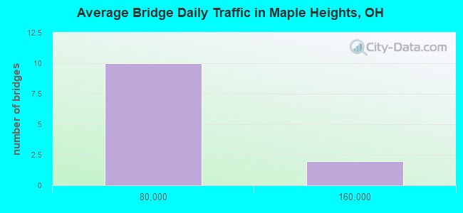
- 443,197Total average daily traffic
- 26,654Total average daily truck traffic
- National Bridge Inventory (NBI) Registered Bridges for Maple Heights
- No street view available for this location
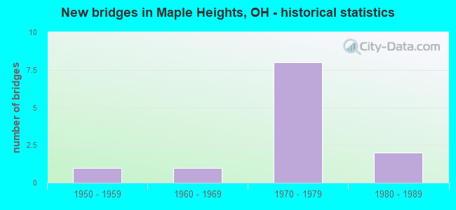
- New bridges - historical statistics
- 11950-1959
- 11960-1969
- 81970-1979
- 21980-1989
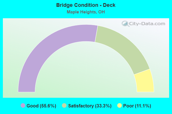
- Bridge Condition - Deck
- 55.6%Good
- 33.3%Satisfactory
- 11.1%Poor
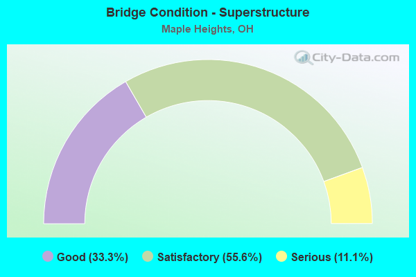
- Bridge Condition - Superstructure
- 33.3%Good
- 55.6%Satisfactory
- 11.1%Serious
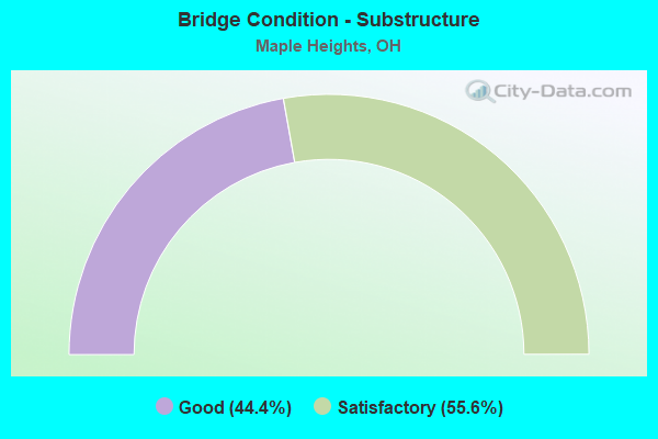
- Bridge Condition - Substructure
- 44.4%Good
- 55.6%Satisfactory
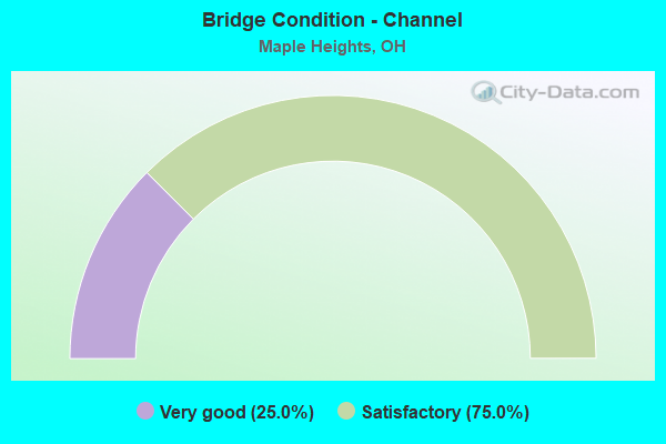
- Bridge Condition - Channel
- 25.0%Very good
- 75.0%Satisfactory
Find on map >> Show street view
Structure Number: 20408, Location: 4.62 mi. West of IR75 (Lat: 40.725989, Lng: -84.149339), Route carried "on" structure: State highway 117, Year Built: 1965, Status: Open, Structure Length: 7.50m (24.61ft), Average Daily Traffic: 13,602 (year 2015), Truck Traffic: 2%, Average Future Daily Traffic: 18,880 (year 2035), Design Load: H 20, Features Intersected: CSX RR
Minimum Vertical Clearance: 30+ m (98+ ft), Kilometerpoint: 22.289, Lanes on structure: 2, Base Highway Network: Yes, Owner: State Highway Agency, Approaching Roadway Width: 8.5m (27.9ft), Skew: 4 degrees, Material/Design: Steel continuous, Design/Construction: Stringer/Multi-beam, Number Of Spans In Main Unit: 3, Length of Maximum Span: 29.3m (96.1ft), Curb or Sidewalk Widths: Left: 0.7m (2.3ft), Right: 0.5m (1.6ft), Curb-To-Curb Width: 9.0m (29.5ft), Out-to-Out Width: 10.5m (34.4ft)
Condition: Deck: Good, Superstructure: Good, Substructure: Good, Operating Rating: 71.3 metric tons, Method Used To Determine Operating Rating: Load Factor (LF) rating reported by rating factor (RF) method using MS18 loading, Inventory Rating: 42.1 metric tons, Method Used To Determine Inventory Rating: Load Factor (LF) rating reported by rating factor (RF) method using MS18 loading, Structural Evaluation: Better than present minimum criteria, Deck Geometry: Meets minimum limits, Underclear: Somewhat better than minimum adequacy, Approach Roadway Alignment: Better than present minimum criteria, Length Of Structure Improvement: 12.19m (39.99ft), Designated Inspection Frequency: Every 24 months, Inspection Date: October 2020, Bridge Improvement Cost: $86,000, Roadway Improvement Cost: $4,000, Total Project Cost: $90,000, Deck Structure Type: Concrete Cast-file-Place, Wearing Surface/Protective System: Wearing Surface: Latex Concrete, Membrane: Built-up
Find on map >> Show street view
Structure Number: 1801856, Location: APPROX 250 FT S I-480 (Lat: 41.423281, Lng: -81.580839), Route carried "on" structure: State highway 14, Year Built: 1987, Status: Open, Structure Length: 1.52m (4.99ft), Average Daily Traffic: 10,144 (year 2015), Truck Traffic: 11%, Average Future Daily Traffic: 14,080 (year 2035), Design Load: HS 20+Mod, Features Intersected: MILL CREEK
Minimum Vertical Clearance: 30+ m (98+ ft), Kilometerpoint: 13.245, Lanes on structure: 4, Base Highway Network: Yes, Toll: On toll road, Owner: State Highway Agency, Approaching Roadway Width: 20.1m (65.9ft), Material/Design: Prestressed concrete, Design/Construction: Box Beam or Girders - Multiple, Number Of Spans In Main Unit: 1, Length of Maximum Span: 14.3m (46.9ft), Curb or Sidewalk Widths: Left: 1.8m (5.9ft), Right: 1.8m (5.9ft), Curb-To-Curb Width: 14.3m (46.9ft), Out-to-Out Width: 20.1m (65.9ft)
Condition: Deck: Good, Superstructure: Good, Substructure: Good, Channel: Satisfactory, Operating Rating: 42.1 metric tons, Method Used To Determine Operating Rating: Load Factor (LF) rating reported by rating factor (RF) method using MS18 loading, Inventory Rating: 32.4 metric tons, Method Used To Determine Inventory Rating: Load Factor (LF) rating reported by rating factor (RF) method using MS18 loading, Structural Evaluation: Better than present minimum criteria, Deck Geometry: High priority of replacement, Waterway Adequacy: Equal to present desirable criteria, Approach Roadway Alignment: Equal to present desirable criteria, Designated Inspection Frequency: Every 24 months, Inspection Date: July 2021, Deck Structure Type: Concrete Cast-file-Place, Wearing Surface/Protective System: Wearing Surface: Bituminous
Find on map >> Show street view
Structure Number: 1802739, Location: .1 MI W BROADWAY (SR-14) (Lat: 41.416989, Lng: -81.577189), Route carried "on" structure: State highway 17, Year Built: 1959, Status: Open, Structure Length: 24.69m (81.00ft), Average Daily Traffic: 12,977 (year 2015), Truck Traffic: 13%, Average Future Daily Traffic: 18,012 (year 2035), Design Load: HS 20, Features Intersected: NSC RR & MILL CR @ SR 14
Minimum Vertical Clearance: 30+ m (98+ ft), Kilometerpoint: 28.727, Lanes on structure: 4, Owner: State Highway Agency, Approaching Roadway Width: 17.4m (57.1ft), Skew: 3 degrees, Material/Design: Steel continuous, Design/Construction: Stringer/Multi-beam, Number Of Spans In Main Unit: 5, Length of Maximum Span: 51.8m (169.9ft), Curb or Sidewalk Widths: Left: 1.8m (5.9ft), Right: 1.8m (5.9ft), Curb-To-Curb Width: 17.4m (57.1ft), Out-to-Out Width: 21.9m (71.9ft)
Condition: Deck: Good, Superstructure: Good, Substructure: Satisfactory, Channel: Satisfactory, Operating Rating: 42.1 metric tons, Method Used To Determine Operating Rating: Load Factor (LF) rating reported by rating factor (RF) method using MS18 loading, Inventory Rating: 32.4 metric tons, Method Used To Determine Inventory Rating: Load Factor (LF) rating reported by rating factor (RF) method using MS18 loading, Structural Evaluation: Equal to present minimum criteria, Deck Geometry: Somewhat better than minimum adequacy, Underclear: Better than present minimum criteria, Waterway Adequacy: Equal to present desirable criteria, Approach Roadway Alignment: Equal to present desirable criteria, Length Of Structure Improvement: 24.69m (81.00ft), Designated Inspection Frequency: Every 12 months, Inspection Date: December 2021, Bridge Improvement Cost: $2,909,000, Roadway Improvement Cost: $291,000, Total Project Cost: $3,200,000, Deck Structure Type: Concrete Cast-file-Place, Wearing Surface/Protective System: Wearing Surface: Latex Concrete
Find on map >> Show street view
Structure Number: 1813374, Location: .15 MI. W. OF JCT. SR-14 (Lat: 41.422581, Lng: -81.584300), Route carried "on" structure: Interstate 480, Year Built: 1976, Status: Open, Structure Length: 15.48m (50.79ft), Average Daily Traffic: 140,781 (year 2015), Truck Traffic: 5%, Average Future Daily Traffic: 195,404 (year 2035), Design Load: HS 20+Mod, Features Intersected: NSC,W&LE RR,& MILL CREEK
Minimum Vertical Clearance: 30+ m (98+ ft), Kilometerpoint: 34.424, Lanes on structure: 4, Base Highway Network: Yes, Owner: State Highway Agency, Approaching Roadway Width: 44.8m (147.0ft), Skew: 12 degrees, Material/Design: Steel continuous, Design/Construction: Stringer/Multi-beam, Number Of Spans In Main Unit: 5, Length of Maximum Span: 33.5m (109.9ft), Curb-To-Curb Width: 45.0m (147.6ft), Out-to-Out Width: 45.2m (148.3ft)
Condition: Deck: Satisfactory, Superstructure: Satisfactory, Substructure: Good, Channel: Very good, Operating Rating: 42.1 metric tons, Method Used To Determine Operating Rating: Allowable Stress (AS) rating reported by rating factor (RF) method using MS18 loading, Inventory Rating: 32.4 metric tons, Method Used To Determine Inventory Rating: Allowable Stress (AS) rating reported by rating factor (RF) method using MS18 loading, Structural Evaluation: Equal to present minimum criteria, Deck Geometry: Superior to present desirable criteria, Underclear: Superior to present desirable criteria, Waterway Adequacy: Equal to present desirable criteria, Approach Roadway Alignment: Equal to present desirable criteria, Designated Inspection Frequency: Every 12 months, Inspection Date: July 2021, Deck Structure Type: Concrete Cast-file-Place, Wearing Surface/Protective System: Wearing Surface: Integral Concrete, Membrane: Built-up, Deck Protection: Other
Find on map >> Show street view
Structure Number: 1813382, Location: JCT. SR-14 WITH I-480 (Lat: 41.423731, Lng: -81.581650), Route carried "on" structure: Interstate 480, Year Built: 1976, Status: Open, Structure Length: 5.64m (18.50ft), Average Daily Traffic: 140,781 (year 2015), Truck Traffic: 5%, Average Future Daily Traffic: 195,404 (year 2035), Design Load: HS 20+Mod, Features Intersected: SR 14 (0822) BROADWAY AV, Facility Carried by Structure: SR-14 BROADWAY AVE
Minimum Vertical Clearance: 30+ m (98+ ft), Kilometerpoint: 34.665, Lanes on structure: 8, Lanes under structure: 4, Base Highway Network: Yes, Owner: State Highway Agency, Approaching Roadway Width: 39.0m (128.0ft), Skew: 12 degrees, Material/Design: Steel continuous, Design/Construction: Stringer/Multi-beam, Number Of Spans In Main Unit: 3, Length of Maximum Span: 22.6m (74.1ft), Curb-To-Curb Width: 48.4m (158.8ft), Out-to-Out Width: 49.9m (163.7ft)
Condition: Deck: Good, Superstructure: Satisfactory, Substructure: Satisfactory, Operating Rating: 42.1 metric tons, Method Used To Determine Operating Rating: Allowable Stress (AS) rating reported by rating factor (RF) method using MS18 loading, Inventory Rating: 32.4 metric tons, Method Used To Determine Inventory Rating: Allowable Stress (AS) rating reported by rating factor (RF) method using MS18 loading, Structural Evaluation: Equal to present minimum criteria, Deck Geometry: Superior to present desirable criteria, Underclear: Meets minimum limits, Approach Roadway Alignment: Equal to present desirable criteria, Designated Inspection Frequency: Every 12 months, Inspection Date: November 2021, Deck Structure Type: Concrete Cast-file-Place, Wearing Surface/Protective System: Wearing Surface: Integral Concrete, Membrane: Built-up
Find on map >> Show street view
Structure Number: 1813854, Location: JCT. SR-8 WITH I-480 (Lat: 41.423189, Lng: -81.527419), Route carried "on" structure: Interstate 480, Year Built: 1971, Status: Open, Structure Length: 6.64m (21.78ft), Average Daily Traffic: 20,841 (year 2015), Truck Traffic: 8%, Average Future Daily Traffic: 28,927 (year 2035), Design Load: HS 20+Mod, Features Intersected: SR 8 (NORTHFIELD RD)
Minimum Vertical Clearance: 30+ m (98+ ft), Kilometerpoint: 39.236, Lanes on structure: 3, Lanes under structure: 6, Base Highway Network: Yes, Owner: State Highway Agency, Approaching Roadway Width: 13.1m (43.0ft), Skew: 3 degrees, Material/Design: Steel continuous, Design/Construction: Stringer/Multi-beam, Number Of Spans In Main Unit: 3, Length of Maximum Span: 35.7m (117.1ft), Curb-To-Curb Width: 11.9m (39.0ft), Out-to-Out Width: 13.1m (43.0ft)
Condition: Deck: Satisfactory, Superstructure: Satisfactory, Substructure: Satisfactory, Operating Rating: 42.1 metric tons, Method Used To Determine Operating Rating: Load and Resistance Factor Rating (LRFR) rating reported by rating factor(RF) method using HL-93 loadings, Inventory Rating: 32.4 metric tons, Method Used To Determine Inventory Rating: Load and Resistance Factor Rating (LRFR) rating reported by rating factor(RF) method using HL-93 loadings, Structural Evaluation: Equal to present minimum criteria, Deck Geometry: High priority of replacement, Underclear: Meets minimum limits, Approach Roadway Alignment: Equal to present desirable criteria, Designated Inspection Frequency: Every 12 months, Inspection Date: January 2021, Deck Structure Type: Concrete Cast-file-Place, Wearing Surface/Protective System: Wearing Surface: Monolithic Concrete
Find on map >> Show street view
Structure Number: 1813862, Location: JCT. SR-8 WITH I-480 (Lat: 41.422950, Lng: -81.527469), Route carried "on" structure: Interstate 480, Year Built: 1971, Status: Open, Structure Length: 6.07m (19.91ft), Average Daily Traffic: 20,841 (year 2015), Truck Traffic: 8%, Average Future Daily Traffic: 28,927 (year 2035), Design Load: HS 20+Mod, Features Intersected: SR 8 (NORTHFIELD RD)
Minimum Vertical Clearance: 30+ m (98+ ft), Kilometerpoint: 39.236, Lanes on structure: 3, Lanes under structure: 6, Base Highway Network: Yes, Owner: State Highway Agency, Approaching Roadway Width: 13.1m (43.0ft), Skew: 3 degrees, Material/Design: Steel continuous, Design/Construction: Stringer/Multi-beam, Number Of Spans In Main Unit: 3, Length of Maximum Span: 32.3m (106.0ft), Curb-To-Curb Width: 11.9m (39.0ft), Out-to-Out Width: 13.2m (43.3ft)
Condition: Deck: Satisfactory, Superstructure: Satisfactory, Substructure: Satisfactory, Operating Rating: 42.1 metric tons, Method Used To Determine Operating Rating: Allowable Stress (AS) rating reported by rating factor (RF) method using MS18 loading, Inventory Rating: 32.4 metric tons, Method Used To Determine Inventory Rating: Allowable Stress (AS) rating reported by rating factor (RF) method using MS18 loading, Structural Evaluation: Equal to present minimum criteria, Deck Geometry: High priority of replacement, Underclear: Meets minimum limits, Approach Roadway Alignment: Equal to present desirable criteria, Designated Inspection Frequency: Every 12 months, Inspection Date: January 2021, Deck Structure Type: Concrete Cast-file-Place, Wearing Surface/Protective System: Wearing Surface: Latex Concrete
Find on map >> Show street view
Structure Number: 1832042, Location: AT BROADWAY ROAD (Lat: 41.402089, Lng: -81.556531), Route carried "on" structure: County highway 53, Year Built: 1981, Status: Open, Structure Length: 21.81m (71.56ft), Average Daily Traffic: 15,713 (year 2015), Truck Traffic: 7%, Average Future Daily Traffic: 21,810 (year 2035), Design Load: HS 20+Mod, Features Intersected: W&LE RR/N&S RR/ACCESS RD
Minimum Vertical Clearance: 30+ m (98+ ft), Kilometerpoint: 11.748, Lanes on structure: 4, Base Highway Network: Yes, Owner: County Highway Agency, Approaching Roadway Width: 15.9m (52.2ft), Skew: 5 degrees, Material/Design: Steel continuous, Design/Construction: Stringer/Multi-beam, Number Of Spans In Main Unit: 6, Length of Maximum Span: 45.3m (148.6ft), Curb or Sidewalk Widths: Left: 1.5m (4.9ft), Right: 1.5m (4.9ft), Curb-To-Curb Width: 15.9m (52.2ft), Out-to-Out Width: 24.4m (80.1ft)
Condition: Deck: Good, Superstructure: Satisfactory, Substructure: Good, Operating Rating: 69.3 metric tons, Method Used To Determine Operating Rating: Load Factor (LF) rating reported by rating factor (RF) method using MS18 loading, Inventory Rating: 41.5 metric tons, Method Used To Determine Inventory Rating: Load Factor (LF) rating reported by rating factor (RF) method using MS18 loading, Structural Evaluation: Equal to present minimum criteria, Deck Geometry: Meets minimum limits, Underclear: Better than present minimum criteria, Approach Roadway Alignment: Superior to present desirable criteria, Designated Inspection Frequency: Every 12 months, Inspection Date: September 2021, Deck Structure Type: Concrete Cast-file-Place, Wearing Surface/Protective System: Wearing Surface: Latex Concrete
Find on map >> Show street view
Structure Number: 1833987, Location: 2485' NORTH OF LIBBY RD (Lat: 41.423619, Lng: -81.564989), Route carried "on" structure: County highway C0008, Year Built: 1971, Status: Posted for load, Structure Length: 1.05m (3.44ft), Average Daily Traffic: 6,035 (year 2015), Truck Traffic: 6%, Average Future Daily Traffic: 8,377 (year 2035), Design Load: HS 20, Features Intersected: MILL CREEK, Facility Carried by Structure: LEE ROAD CR 8
Minimum Vertical Clearance: 30+ m (98+ ft), Kilometerpoint: 1.239, Lanes on structure: 4, Owner: County Highway Agency, Approaching Roadway Width: 21.3m (69.9ft), Skew: 1 degrees, Material/Design: Prestressed concrete, Design/Construction: Stringer/Multi-beam, Number Of Spans In Main Unit: 1, Length of Maximum Span: 9.1m (29.9ft), Curb or Sidewalk Widths: Left: 4.0m (13.1ft), Right: 4.0m (13.1ft), Curb-To-Curb Width: 21.2m (69.6ft), Out-to-Out Width: 29.7m (97.4ft)
Condition: Deck: Poor, Superstructure: Serious, Substructure: Satisfactory, Channel: Satisfactory, Operating Rating: 18.8 metric tons, Method Used To Determine Operating Rating: Load Factor (LF) rating reported by rating factor (RF) method using MS18 loading, Inventory Rating: 14.6 metric tons, Method Used To Determine Inventory Rating: Load Factor (LF) rating reported by rating factor (RF) method using MS18 loading, Structural Evaluation: High priority of corrective action, Deck Geometry: Superior to present desirable criteria, Waterway Adequacy: Superior to present desirable criteria, Approach Roadway Alignment: Superior to present desirable criteria, Bridge Posting: Required (Relationship of Operating Rating to Maximum Legal Load: > 39.9% below), Designated Inspection Frequency: Every 12 months, Inspection Date: October 2021, Deck Structure Type: Concrete Cast-file-Place, Wearing Surface/Protective System: Wearing Surface: Monolithic Concrete
Find on map >> Show street view
Structure Number: 1813382, Location: JCT. SR-14 WITH I-480 (Lat: 41.423731, Lng: -81.581650), Route carried "under" structure: State highway 14, Year Built: 1976, Structure Length: 0. m, Average Daily Traffic: 10,144 (year 2015), Truck Traffic: 11%, Features Intersected: I-480 (CUY-480-2154)
Minimum Vertical Clearance: 4.80m (15.75ft), Kilometerpoint: 13.229, Lanes on structure: 8, Lanes under structure: 4, Material/Design: Steel continuous, Design/Construction: Stringer/Multi-beam, Length of Maximum Span: 22.6m (74.1ft)
Find on map >> Show street view
Structure Number: 1813854, Location: JCT. SR-8 WITH I-480 (Lat: 41.423189, Lng: -81.527419), Route carried "under" structure: State highway 8, Year Built: 1971, Structure Length: 0. m, Average Daily Traffic: 25,669 (year 2015), Truck Traffic: 7%, Features Intersected: I-480 WB (CUY-480-2438L)
Minimum Vertical Clearance: 4.62m (15.16ft), Kilometerpoint: 8.175, Lanes on structure: 3, Lanes under structure: 6, Material/Design: Steel continuous, Design/Construction: Stringer/Multi-beam, Length of Maximum Span: 35.7m (117.1ft)
Find on map >> Show street view
Structure Number: 1813862, Location: JCT. SR-8 WITH I-480 (Lat: 41.422950, Lng: -81.527469), Route carried "under" structure: State highway 8, Year Built: 1971, Structure Length: 0. m, Average Daily Traffic: 25,669 (year 2015), Truck Traffic: 7%, Features Intersected: I-480 EB (CUY-480-2438R)
Minimum Vertical Clearance: 4.58m (15.03ft), Kilometerpoint: 8.143, Lanes on structure: 3, Lanes under structure: 6, Material/Design: Steel continuous, Design/Construction: Stringer/Multi-beam, Length of Maximum Span: 32.3m (106.0ft)