Bridge Statistics for Marmet, West Virginia (WV)
Condition, Traffic, Stress, Structural Evaluation, Project Costs
- National Bridge Inventory (NBI) Statistics
- 17Number of bridges
- 328ft / 100mTotal length
- $750,000Total costs
- 243,345Total average daily traffic
- 42,874Total average daily truck traffic
- National Bridge Inventory (NBI) Registered Bridges for Marmet
- No street view available for this location
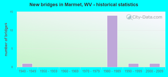
- New bridges - historical statistics
- 11940-1949
- 141980-1989
- 11990-1999
- 12000-2009
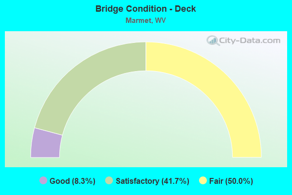
- Bridge Condition - Deck
- 8.3%Good
- 41.7%Satisfactory
- 50.0%Fair
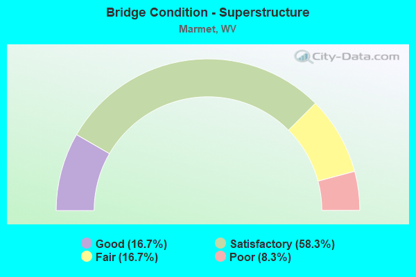
- Bridge Condition - Superstructure
- 16.7%Good
- 58.3%Satisfactory
- 16.7%Fair
- 8.3%Poor
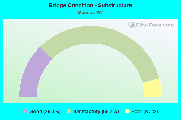
- Bridge Condition - Substructure
- 25.0%Good
- 66.7%Satisfactory
- 8.3%Poor
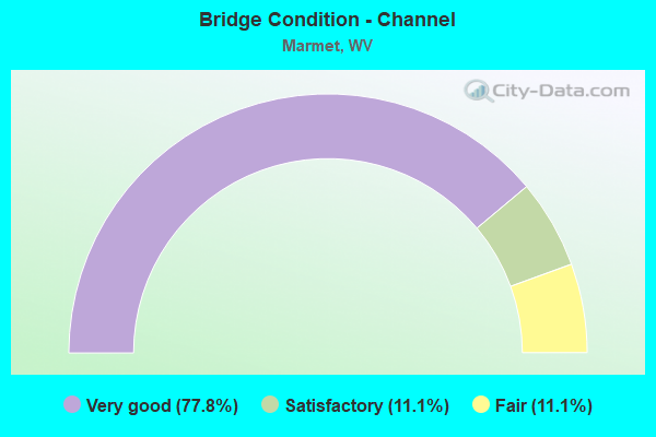
- Bridge Condition - Channel
- 77.8%Very good
- 11.1%Satisfactory
- 11.1%Fair
Find on map >> Show street view
Structure Number: 20A203, Location: 0.05 MI S OF WV 94 (Lat: 38.226989, Lng: -81.579869), Route carried "on" structure: County highway 68, Year Built: 1989, Status: Open, Structure Length: 1.81m (5.94ft), Average Daily Traffic: 200 (year 2019), Truck Traffic: 5%, Average Future Daily Traffic: 244 (year 2039), Design Load: HS 25 or greater, Features Intersected: LENS CREEK
Minimum Vertical Clearance: 30+ m (98+ ft), Kilometerpoint: 0.080, Lanes on structure: 2, Owner: State Highway Agency, Approaching Roadway Width: 5.5m (18.0ft), Material/Design: Prestressed concrete, Design/Construction: Box Beam or Girders - Multiple, Number Of Spans In Main Unit: 1, Length of Maximum Span: 17.7m (58.1ft), Curb-To-Curb Width: 5.6m (18.4ft), Out-to-Out Width: 5.6m (18.4ft)
Condition: Deck: Satisfactory, Superstructure: Good, Substructure: Satisfactory, Channel: Satisfactory, Operating Rating: 88.9 metric tons, Method Used To Determine Operating Rating: Load Factor (LF), Inventory Rating: 62.6 metric tons, Method Used To Determine Inventory Rating: Load Factor (LF), Structural Evaluation: Equal to present minimum criteria, Deck Geometry: High priority of corrective action, Waterway Adequacy: Better than present minimum criteria, Approach Roadway Alignment: High priority of corrective action, Length Of Structure Improvement: 1.81m (5.94ft), Designated Inspection Frequency: Every 24 months, Inspection Date: April 2021, Deck Structure Type: Other, Wearing Surface/Protective System: Wearing Surface: Monolithic Concrete
Find on map >> Show street view
Structure Number: 20A552, Location: 0.04 MI. S. OF CR 23/12 (Lat: 38.261700, Lng: -81.573989), Route carried "on" structure: State highway 61, Year Built: 1982, Status: Open, Structure Length: 3.15m (10.33ft), Average Daily Traffic: 4,300 (year 2020), Truck Traffic: 5%, Average Future Daily Traffic: 4,601 (year 2040), Design Load: HS 20, Features Intersected: RUSH CREEK
Minimum Vertical Clearance: 30+ m (98+ ft), Kilometerpoint: 28.888, Lanes on structure: 2, Owner: State Highway Agency, Approaching Roadway Width: 11.3m (37.1ft), Material/Design: Steel, Design/Construction: Stringer/Multi-beam, Number Of Spans In Main Unit: 1, Length of Maximum Span: 29.9m (98.1ft), Curb-To-Curb Width: 11.6m (38.1ft), Out-to-Out Width: 12.6m (41.3ft)
Condition: Deck: Satisfactory, Superstructure: Satisfactory, Substructure: Good, Channel: Very good, Operating Rating: 88.9 metric tons, Method Used To Determine Operating Rating: Load Factor (LF), Inventory Rating: 72.6 metric tons, Method Used To Determine Inventory Rating: Load Factor (LF), Structural Evaluation: Equal to present minimum criteria, Deck Geometry: Somewhat better than minimum adequacy, Waterway Adequacy: Superior to present desirable criteria, Approach Roadway Alignment: Equal to present desirable criteria, Length Of Structure Improvement: 3.15m (10.33ft), Designated Inspection Frequency: Every 24 months, Inspection Date: October 2021, Bridge Improvement Cost: $225,000, Roadway Improvement Cost: $50,000, Total Project Cost: $275,000 ( Estimate for 2019), Deck Structure Type: Concrete Cast-file-Place, Wearing Surface/Protective System: Wearing Surface: Monolithic Concrete, Deck Protection: Epoxy Coated Reinforcing
Find on map >> Show street view
Structure Number: 20A621, Location: 0.02 MI OF 94 (Lat: 38.240489, Lng: -81.564431), Route carried "on" structure: Ramp Interstate 7700, Year Built: 1981, Status: Open, Structure Length: 7.96m (26.12ft), Average Daily Traffic: 34,418 (year 2018), Truck Traffic: 17%, Average Future Daily Traffic: 60,232 (year 2038), Design Load: HS 20+Mod, Features Intersected: LENS CREEK, Facility Carried by Structure: I-77 NB EXIT
Minimum Vertical Clearance: 30+ m (98+ ft), Kilometerpoint: 143.811, Lanes on structure: 1, Base Highway Network: Yes, Toll: On Interstate toll segment, Owner: State Toll Authority, Approaching Roadway Width: 7.3m (24.0ft), Skew: 10 degrees, Material/Design: Steel continuous, Design/Construction: Stringer/Multi-beam, Number Of Spans In Main Unit: 1, Number Of Approach Spans: 2, Length of Maximum Span: 29.3m (96.1ft), Curb-To-Curb Width: 8.3m (27.2ft), Out-to-Out Width: 9.3m (30.5ft)
Condition: Deck: Fair, Superstructure: Fair, Substructure: Satisfactory, Channel: Very good, Operating Rating: 36.3 metric tons, Method Used To Determine Operating Rating: Load Factor (LF), Inventory Rating: 34.5 metric tons, Method Used To Determine Inventory Rating: Load Factor (LF), Structural Evaluation: Somewhat better than minimum adequacy, Deck Geometry: Superior to present desirable criteria, Waterway Adequacy: Superior to present desirable criteria, Approach Roadway Alignment: Equal to present desirable criteria, Designated Inspection Frequency: Every 24 months, Inspection Date: August 2020, Deck Structure Type: Concrete Cast-file-Place, Wearing Surface/Protective System: Wearing Surface: Monolithic Concrete, Deck Protection: Epoxy Coated Reinforcing
Find on map >> Show street view
Structure Number: 20A622, Location: 0.01 MI. N. OF RTE. 94 (Lat: 38.240331, Lng: -81.564850), Route carried "on" structure: Interstate 7700, Year Built: 1981, Status: Open, Structure Length: 15.03m (49.31ft), Average Daily Traffic: 34,418 (year 2018), Truck Traffic: 17%, Average Future Daily Traffic: 60,232 (year 2038), Design Load: HS 20+Mod, Features Intersected: Route 94 and Lens Creek, Facility Carried by Structure: I-77
Minimum Vertical Clearance: 30+ m (98+ ft), Kilometerpoint: 143.940, Lanes on structure: 4, Lanes under structure: 2, Base Highway Network: Yes, Toll: On Interstate toll segment, Owner: State Toll Authority, Approaching Roadway Width: 25.0m (82.0ft), Skew: 10 degrees, Material/Design: Steel continuous, Design/Construction: Stringer/Multi-beam, Number Of Spans In Main Unit: 1, Number Of Approach Spans: 5, Length of Maximum Span: 29.9m (98.1ft), Curb-To-Curb Width: 25.9m (85.0ft), Out-to-Out Width: 27.0m (88.6ft)
Condition: Deck: Satisfactory, Superstructure: Fair, Substructure: Satisfactory, Channel: Very good, Operating Rating: 59.0 metric tons, Method Used To Determine Operating Rating: Load Factor (LF), Inventory Rating: 35.4 metric tons, Method Used To Determine Inventory Rating: Load Factor (LF), Structural Evaluation: Somewhat better than minimum adequacy, Deck Geometry: Superior to present desirable criteria, Underclear: Equal to present minimum criteria, Waterway Adequacy: Equal to present desirable criteria, Approach Roadway Alignment: Equal to present desirable criteria, Designated Inspection Frequency: Every 24 months, Other Special Inspection Frequency: Every 12 months, Inspection Date: August 2020, Other Special Inspection Date: August 2021, Deck Structure Type: Concrete Cast-file-Place, Wearing Surface/Protective System: Wearing Surface: Monolithic Concrete, Deck Protection: Epoxy Coated Reinforcing
Find on map >> Show street view
Structure Number: 20A624, Location: 0.02 MI. S. OF RT.94 (Lat: 38.239961, Lng: -81.564961), Route carried "on" structure: Ramp Interstate 7700, Year Built: 1981, Status: Open, Structure Length: 8.66m (28.41ft), Average Daily Traffic: 1,787 (year 2019), Truck Traffic: 17%, Average Future Daily Traffic: 3,128 (year 2039), Design Load: HS 20+Mod, Features Intersected: LENS CREEK, Facility Carried by Structure: I-77 SB ENTRANCE
Minimum Vertical Clearance: 30+ m (98+ ft), Kilometerpoint: 144.004, Lanes on structure: 1, Base Highway Network: Yes, Toll: On Interstate toll segment, Owner: State Toll Authority, Approaching Roadway Width: 8.5m (27.9ft), Skew: 10 degrees, Material/Design: Steel continuous, Design/Construction: Stringer/Multi-beam, Number Of Spans In Main Unit: 1, Number Of Approach Spans: 2, Length of Maximum Span: 35.1m (115.2ft), Curb-To-Curb Width: 8.3m (27.2ft), Out-to-Out Width: 9.3m (30.5ft)
Condition: Deck: Fair, Superstructure: Satisfactory, Substructure: Satisfactory, Channel: Very good, Operating Rating: 55.3 metric tons, Method Used To Determine Operating Rating: Load Factor (LF), Inventory Rating: 34.5 metric tons, Method Used To Determine Inventory Rating: Load Factor (LF), Structural Evaluation: Equal to present minimum criteria, Deck Geometry: Superior to present desirable criteria, Waterway Adequacy: Superior to present desirable criteria, Approach Roadway Alignment: Equal to present desirable criteria, Designated Inspection Frequency: Every 24 months, Inspection Date: August 2020, Deck Structure Type: Concrete Cast-file-Place, Wearing Surface/Protective System: Wearing Surface: Monolithic Concrete, Deck Protection: Epoxy Coated Reinforcing
Find on map >> Show street view
Structure Number: 20A625, Location: 0.17 MI N OF MARMET I/L (Lat: 38.242489, Lng: -81.567711), Route carried "on" structure: Interstate 7700, Year Built: 1981, Status: Open, Structure Length: 6.37m (20.90ft), Average Daily Traffic: 34,418 (year 2019), Truck Traffic: 28%, Average Future Daily Traffic: 35,129 (year 2039), Design Load: HS 20+Mod, Features Intersected: 98th Street in Marmet, Facility Carried by Structure: I-77
Minimum Vertical Clearance: 30+ m (98+ ft), Kilometerpoint: 144.326, Lanes on structure: 6, Lanes under structure: 2, Base Highway Network: Yes, Toll: On Interstate toll segment, Owner: State Toll Authority, Approaching Roadway Width: 25.0m (82.0ft), Skew: 30 degrees, Material/Design: Steel continuous, Design/Construction: Stringer/Multi-beam, Number Of Spans In Main Unit: 1, Number Of Approach Spans: 2, Length of Maximum Span: 24.1m (79.1ft), Curb-To-Curb Width: 37.1m (121.7ft), Out-to-Out Width: 38.2m (125.3ft)
Condition: Deck: Fair, Superstructure: Satisfactory, Substructure: Satisfactory, Operating Rating: 59.9 metric tons, Method Used To Determine Operating Rating: Load Factor (LF), Inventory Rating: 36.3 metric tons, Method Used To Determine Inventory Rating: Load Factor (LF), Structural Evaluation: Equal to present minimum criteria, Deck Geometry: Superior to present desirable criteria, Underclear: Meets minimum limits, Approach Roadway Alignment: Equal to present desirable criteria, Designated Inspection Frequency: Every 24 months, Inspection Date: December 2020, Deck Structure Type: Concrete Cast-file-Place, Wearing Surface/Protective System: Wearing Surface: Epoxy Overlay, Membrane: Epoxy, Deck Protection: Epoxy Coated Reinforcing
Find on map >> Show street view
Structure Number: 20A627, Location: 0.81 MI N OF WV 94 (Lat: 38.250681, Lng: -81.572850), Route carried "on" structure: Interstate 7700, Year Built: 1982, Status: Open, Structure Length: 4.21m (13.81ft), Average Daily Traffic: 39,878 (year 2015), Truck Traffic: 17%, Average Future Daily Traffic: 69,786 (year 2035), Design Load: HS 20+Mod, Features Intersected: 85th Street, Marmet, WV, Facility Carried by Structure: I-77
Minimum Vertical Clearance: 30+ m (98+ ft), Kilometerpoint: 145.356, Lanes on structure: 4, Lanes under structure: 2, Base Highway Network: Yes, Toll: On Interstate toll segment, Owner: State Toll Authority, Approaching Roadway Width: 25.9m (85.0ft), Skew: 31 degrees, Material/Design: Steel continuous, Design/Construction: Stringer/Multi-beam, Number Of Spans In Main Unit: 1, Number Of Approach Spans: 2, Length of Maximum Span: 16.5m (54.1ft), Curb-To-Curb Width: 25.6m (84.0ft), Out-to-Out Width: 27.6m (90.6ft)
Condition: Deck: Fair, Superstructure: Satisfactory, Substructure: Satisfactory, Channel: Very good, Operating Rating: 59.0 metric tons, Method Used To Determine Operating Rating: Load Factor (LF), Inventory Rating: 35.4 metric tons, Method Used To Determine Inventory Rating: Load Factor (LF), Structural Evaluation: Equal to present minimum criteria, Deck Geometry: Superior to present desirable criteria, Underclear: Superior to present desirable criteria, Approach Roadway Alignment: Equal to present desirable criteria, Designated Inspection Frequency: Every 24 months, Inspection Date: May 2021, Deck Structure Type: Concrete Cast-file-Place, Wearing Surface/Protective System: Wearing Surface: Monolithic Concrete, Deck Protection: Epoxy Coated Reinforcing
Find on map >> Show street view
Structure Number: 20A629, Location: 1.40 MI N OF RT 94 (Lat: 38.257111, Lng: -81.573819), Route carried "on" structure: Interstate 7700, Year Built: 1982, Status: Open, Structure Length: 23.59m (77.40ft), Average Daily Traffic: 19,879 (year 2019), Truck Traffic: 17%, Average Future Daily Traffic: 34,789 (year 2039), Design Load: HS 20+Mod, Features Intersected: WV Route 61 and CSX RR, Facility Carried by Structure: I-77
Minimum Vertical Clearance: 30+ m (98+ ft), Kilometerpoint: 146.016, Lanes on structure: 2, Lanes under structure: 2, Base Highway Network: Yes, Toll: On Interstate toll segment, Owner: State Toll Authority, Approaching Roadway Width: 12.5m (41.0ft), Skew: 10 degrees, Material/Design: Steel, Design/Construction: Stringer/Multi-beam, Number Of Spans In Main Unit: 2, Number Of Approach Spans: 6, Length of Maximum Span: 33.5m (109.9ft), Curb-To-Curb Width: 13.0m (42.7ft), Out-to-Out Width: 14.6m (47.9ft)
Condition: Deck: Satisfactory, Superstructure: Satisfactory, Substructure: Good, Operating Rating: 56.2 metric tons, Method Used To Determine Operating Rating: Load Factor (LF), Inventory Rating: 33.6 metric tons, Method Used To Determine Inventory Rating: Load Factor (LF), Structural Evaluation: Equal to present minimum criteria, Deck Geometry: Somewhat better than minimum adequacy, Underclear: Equal to present desirable criteria, Approach Roadway Alignment: Equal to present desirable criteria, Designated Inspection Frequency: Every 24 months, Critical Feature Inspection Frequency: Every 24 months, Inspection Date: June 2021, Critical Feature Inspection Date: June 2021, Deck Structure Type: Concrete Cast-file-Place, Wearing Surface/Protective System: Wearing Surface: Monolithic Concrete, Deck Protection: Epoxy Coated Reinforcing
Find on map >> Show street view
Structure Number: 20A63, Location: 1.40 MI. N. OF WV 94 (Lat: 38.257100, Lng: -81.573681), Route carried "on" structure: Interstate 7700, Year Built: 1982, Status: Open, Structure Length: 23.90m (78.41ft), Average Daily Traffic: 19,879 (year 2019), Truck Traffic: 17%, Average Future Daily Traffic: 34,789 (year 2039), Design Load: HS 20+Mod, Features Intersected: ROUTE 61 & CSX RAILROAD, Facility Carried by Structure: I-77
Minimum Vertical Clearance: 30+ m (98+ ft), Kilometerpoint: 146.016, Lanes on structure: 2, Lanes under structure: 2, Base Highway Network: Yes, Toll: On Interstate toll segment, Owner: State Toll Authority, Approaching Roadway Width: 12.5m (41.0ft), Material/Design: Steel, Design/Construction: Stringer/Multi-beam, Number Of Spans In Main Unit: 2, Number Of Approach Spans: 7, Length of Maximum Span: 32.0m (105.0ft), Curb-To-Curb Width: 13.0m (42.7ft), Out-to-Out Width: 14.1m (46.3ft)
Condition: Deck: Fair, Superstructure: Satisfactory, Substructure: Satisfactory, Operating Rating: 61.7 metric tons, Method Used To Determine Operating Rating: Load Factor (LF), Inventory Rating: 36.3 metric tons, Method Used To Determine Inventory Rating: Load Factor (LF), Structural Evaluation: Equal to present minimum criteria, Deck Geometry: Superior to present desirable criteria, Underclear: Equal to present desirable criteria, Approach Roadway Alignment: Equal to present desirable criteria, Designated Inspection Frequency: Every 24 months, Critical Feature Inspection Frequency: Every 24 months, Inspection Date: June 2021, Critical Feature Inspection Date: June 2021, Deck Structure Type: Concrete Cast-file-Place, Wearing Surface/Protective System: Wearing Surface: Monolithic Concrete, Deck Protection: Epoxy Coated Reinforcing
Find on map >> Show street view
Structure Number: 20A631, Location: 1.59 MI N OF US 119 I/C (Lat: 38.261739, Lng: -81.573750), Route carried "on" structure: Interstate 7700, Year Built: 1983, Status: Open, Structure Length: 3.11m (10.20ft), Average Daily Traffic: 39,759 (year 2019), Truck Traffic: 17%, Average Future Daily Traffic: 69,578 (year 2039), Design Load: HS 20+Mod, Features Intersected: RUSH CREEK, Facility Carried by Structure: I-77 WV 61
Minimum Vertical Clearance: 30+ m (98+ ft), Kilometerpoint: 146.595, Lanes on structure: 4, Toll: On Interstate toll segment, Owner: State Toll Authority, Approaching Roadway Width: 37.2m (122.0ft), Material/Design: Steel continuous, Design/Construction: Stringer/Multi-beam, Number Of Spans In Main Unit: 1, Length of Maximum Span: 29.9m (98.1ft), Curb-To-Curb Width: 38.9m (127.6ft), Out-to-Out Width: 39.9m (130.9ft)
Condition: Deck: Fair, Superstructure: Good, Substructure: Satisfactory, Channel: Very good, Operating Rating: 88.9 metric tons, Method Used To Determine Operating Rating: Load Factor (LF), Inventory Rating: 54.4 metric tons, Method Used To Determine Inventory Rating: Load Factor (LF), Structural Evaluation: Equal to present minimum criteria, Deck Geometry: Superior to present desirable criteria, Waterway Adequacy: Superior to present desirable criteria, Approach Roadway Alignment: Equal to present desirable criteria, Designated Inspection Frequency: Every 24 months, Inspection Date: October 2021, Deck Structure Type: Concrete Cast-file-Place, Wearing Surface/Protective System: Wearing Surface: Monolithic Concrete, Deck Protection: Epoxy Coated Reinforcing
Find on map >> Show street view
Structure Number: 20A816, Location: 0.09 MIL E OF WV 94 (Lat: 38.227500, Lng: -81.596889), Route carried "on" structure: Other road 94900, Year Built: 2005, Status: Open, Structure Length: 1.16m (3.81ft), Average Daily Traffic: 30 (year 2020), Truck Traffic: 5%, Average Future Daily Traffic: 39 (year 2040), Design Load: HS 25 or greater, Features Intersected: LENS CREEK, Facility Carried by Structure: CR 949
Minimum Vertical Clearance: 30+ m (98+ ft), Kilometerpoint: 0.145, Lanes on structure: 1, Owner: State Highway Agency, Approaching Roadway Width: 4.3m (14.1ft), Skew: 1 degrees, Material/Design: Prestressed concrete, Design/Construction: Box Beam or Girders - Multiple, Number Of Spans In Main Unit: 1, Length of Maximum Span: 10.4m (34.1ft), Curb-To-Curb Width: 3.7m (12.1ft), Out-to-Out Width: 3.7m (12.1ft)
Condition: Deck: Satisfactory, Superstructure: Satisfactory, Substructure: Good, Channel: Very good, Operating Rating: 86.2 metric tons, Method Used To Determine Operating Rating: Load Factor (LF), Inventory Rating: 51.7 metric tons, Method Used To Determine Inventory Rating: Load Factor (LF), Structural Evaluation: Equal to present minimum criteria, Deck Geometry: Meets minimum limits, Waterway Adequacy: Meets minimum limits, Approach Roadway Alignment: Somewhat better than minimum adequacy, Designated Inspection Frequency: Every 24 months, Inspection Date: July 2021, Deck Structure Type: Other, Wearing Surface/Protective System: Wearing Surface: Monolithic Concrete, Deck Protection: Epoxy Coated Reinforcing
Find on map >> Show street view
Structure Number: 20A918, Location: 0.01 MI E OF WV 94 (Lat: 38.232911, Lng: -81.571419), Route carried "on" structure: City street N0990, Year Built: 1992, Status: Posted for load, Structure Length: 1.23m (4.04ft), Average Daily Traffic: 20 (year 2020), Average Future Daily Traffic: 20 (year 2040), Features Intersected: LENS CREEK, Facility Carried by Structure: MARMET CITY STREET
Minimum Vertical Clearance: 30+ m (98+ ft), Kilometerpoint: 0.016, Lanes on structure: 1, Owner: City or Municipal Highway Agency, Approaching Roadway Width: 3.0m (9.8ft), Material/Design: Steel, Design/Construction: Stringer/Multi-beam, Number Of Spans In Main Unit: 1, Length of Maximum Span: 10.7m (35.1ft), Curb or Sidewalk Widths: Left: 0.1m (0.3ft), Right: 0.1m (0.3ft), Curb-To-Curb Width: 3.0m (9.8ft), Out-to-Out Width: 3.0m (9.8ft)
Condition: Deck: Good, Superstructure: Poor, Substructure: Poor, Channel: Fair, Operating Rating: 3.6 metric tons, Method Used To Determine Operating Rating: Load Factor (LF), Inventory Rating: 2.7 metric tons, Method Used To Determine Inventory Rating: Load Factor (LF), Structural Evaluation: High priority of replacement, Deck Geometry: High priority of replacement, Waterway Adequacy: Somewhat better than minimum adequacy, Approach Roadway Alignment: High priority of corrective action, Bridge Posting: Required (Relationship of Operating Rating to Maximum Legal Load: > 39.9% below), Length Of Structure Improvement: 1.83m (6.00ft), Designated Inspection Frequency: Every 24 months, Critical Feature Inspection Frequency: Every 12 months, Inspection Date: December 2021, Critical Feature Inspection Date: December 2021, Bridge Improvement Cost: $400,000, Roadway Improvement Cost: $75,000, Total Project Cost: $475,000 ( Estimate for 2019), Deck Structure Type: Open Grating, Wearing Surface/Protective System: Wearing Surface: Other
Find on map >> Show street view
Structure Number: 20A314, Location: 0.06 MI N OF WV 61 F (Lat: 38.261731, Lng: -81.575019), Route carried "under" structure: County highway 2312, Year Built: 1944, Structure Length: 0. m, Average Daily Traffic: 9 (year 2017), Truck Traffic: 5%, Features Intersected: CR 23/12 AND RUSH CREEK, Facility Carried by Structure: CSX RR #445.60
Minimum Vertical Clearance: 4.09m (13.42ft), Kilometerpoint: 0.097, Lanes under structure: 1, Length of Maximum Span: 8.0m (26.2ft)
Find on map >> Show street view
Structure Number: 20A625, Location: 0.17 MI N OF MARMET I/L (Lat: 38.242489, Lng: -81.567711), Route carried "under" structure: City street , Year Built: 1981, Structure Length: 0. m, Average Daily Traffic: 50 (year 0007), Features Intersected: 98th Street in Marmet, Facility Carried by Structure: I-77
Minimum Vertical Clearance: 13.64m (44.75ft), Kilometerpoint: 0.000, Lanes on structure: 6, Lanes under structure: 2, Toll: On Interstate toll segment, Length of Maximum Span: 24.1m (79.1ft)
Find on map >> Show street view
Structure Number: 20A627, Location: 0.81 MI N OF WV 94 (Lat: 38.250681, Lng: -81.572850), Route carried "under" structure: ServiceCity street , Year Built: 1982, Structure Length: 0. m, Average Daily Traffic: 100 (year 0007), Features Intersected: 85th Street, Marmet, WV, Facility Carried by Structure: I-77
Minimum Vertical Clearance: 5.69m (18.67ft), Kilometerpoint: 0.000, Lanes on structure: 4, Lanes under structure: 2, Toll: On Interstate toll segment, Length of Maximum Span: 16.5m (54.1ft)
Structure Number: 20A629, Location: 1.40 MI N OF RT 94, Route carried "under" structure: State highway 6100, Year Built: 1982, Structure Length: 0. m, Average Daily Traffic: 7,100 (year 0009), Truck Traffic: 5%, Features Intersected: WV Route 61 and CSX RR, Facility Carried by Structure: I-77
Minimum Vertical Clearance: 6.40m (21.00ft), Kilometerpoint: 28.324, Lanes on structure: 2, Lanes under structure: 2, Toll: On Interstate toll segment, Length of Maximum Span: 33.5m (109.9ft)
Minimum Vertical Clearance: 6.40m (21.00ft), Kilometerpoint: 28.324, Lanes on structure: 2, Lanes under structure: 2, Toll: On Interstate toll segment, Length of Maximum Span: 33.5m (109.9ft)
Structure Number: 20A63, Location: 1.40 MI. N. OF WV 94, Route carried "under" structure: State highway 6100, Year Built: 1982, Structure Length: 0. m, Average Daily Traffic: 7,100 (year 0009), Truck Traffic: 5%, Features Intersected: ROUTE 61 & CSX RAILROAD, Facility Carried by Structure: I-77
Minimum Vertical Clearance: 7.01m (23.00ft), Kilometerpoint: 28.324, Lanes on structure: 2, Lanes under structure: 2, Toll: On Interstate toll segment, Length of Maximum Span: 32.0m (105.0ft)
Minimum Vertical Clearance: 7.01m (23.00ft), Kilometerpoint: 28.324, Lanes on structure: 2, Lanes under structure: 2, Toll: On Interstate toll segment, Length of Maximum Span: 32.0m (105.0ft)