Bridge Statistics for McKenney, Virginia (VA)
Condition, Traffic, Stress, Structural Evaluation, Project Costs
- National Bridge Inventory (NBI) Statistics
- 18Number of bridges
- 299ft / 90.5mTotal length
- $1,654,000Total costs
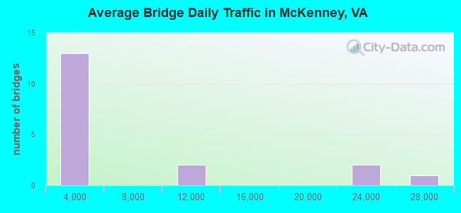
- 100,061Total average daily traffic
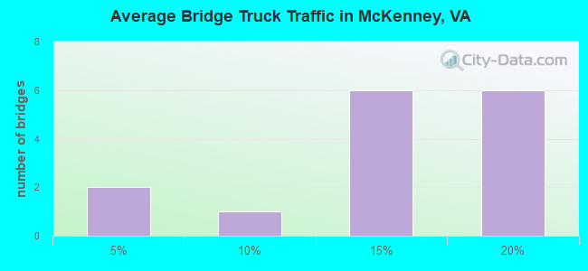
- 13,663Total average daily truck traffic
- National Bridge Inventory (NBI) Registered Bridges for McKenney
- No street view available for this location
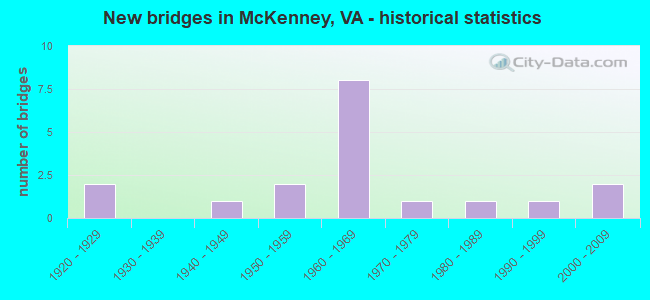
- New bridges - historical statistics
- 21920-1929
- 11940-1949
- 21950-1959
- 81960-1969
- 11970-1979
- 11980-1989
- 11990-1999
- 22000-2009
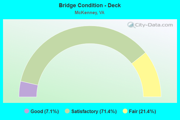
- Bridge Condition - Deck
- 7.1%Good
- 71.4%Satisfactory
- 21.4%Fair
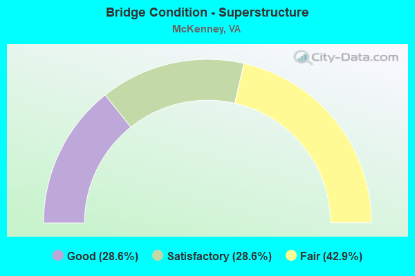
- Bridge Condition - Superstructure
- 28.6%Good
- 28.6%Satisfactory
- 42.9%Fair
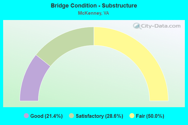
- Bridge Condition - Substructure
- 21.4%Good
- 28.6%Satisfactory
- 50.0%Fair
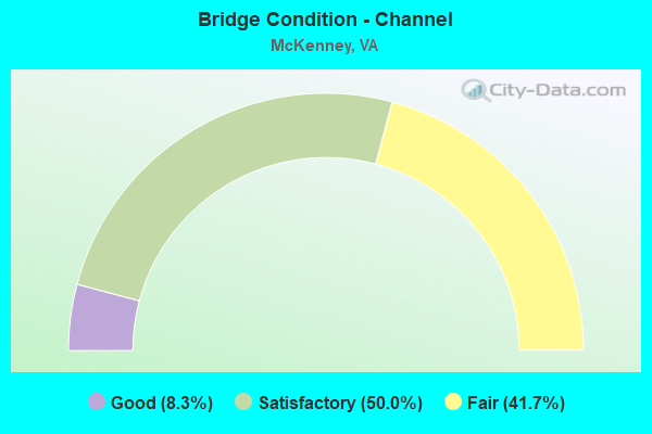
- Bridge Condition - Channel
- 8.3%Good
- 50.0%Satisfactory
- 41.7%Fair
Find on map >> Show street view
Structure Number: 3565, Location: 0000DINWID CO0000BRUNSW C (Lat: 36.945167, Lng: -77.733856), Route carried "on" structure: US 1, Year Built: 1947, Status: Open, Structure Length: 14.63m (48.00ft), Average Daily Traffic: 635 (year 2020), Truck Traffic: 10%, Average Future Daily Traffic: 828 (year 2040), Design Load: H 20, Features Intersected: NOTTOWAY RIVER, Facility Carried by Structure: BOYDTON PLANK RD.
Minimum Vertical Clearance: 30+ m (98+ ft), Kilometerpoint: 68.511, Lanes on structure: 2, Owner: State Highway Agency, Approaching Roadway Width: 9.1m (29.9ft), Material/Design: Steel continuous, Design/Construction: Stringer/Multi-beam, Number Of Spans In Main Unit: 3, Number Of Approach Spans: 6, Length of Maximum Span: 25.9m (85.0ft), Curb-To-Curb Width: 8.5m (27.9ft), Out-to-Out Width: 9.5m (31.2ft)
Condition: Deck: Satisfactory, Superstructure: Fair, Substructure: Fair, Channel: Satisfactory, Operating Rating: 48.1 metric tons, Method Used To Determine Operating Rating: Load and Resistance Factor (LRFR), Inventory Rating: 37.2 metric tons, Method Used To Determine Inventory Rating: Load and Resistance Factor (LRFR), Structural Evaluation: Somewhat better than minimum adequacy, Deck Geometry: High priority of corrective action, Waterway Adequacy: Equal to present minimum criteria, Approach Roadway Alignment: Equal to present desirable criteria, Length Of Structure Improvement: 14.63m (48.00ft), Designated Inspection Frequency: Every 24 months, Inspection Date: September 2021, Bridge Improvement Cost: $864,000, Roadway Improvement Cost: $86,000, Total Project Cost: $1,149,000, Deck Structure Type: Concrete Cast-file-Place, Wearing Surface/Protective System: Deck Protection: Epoxy Coated Reinforcing
Find on map >> Show street view
Structure Number: 3761, Location: 2.4 FR 631 & 0.3 TO US1 (Lat: 36.937378, Lng: -77.734656), Route carried "on" structure: County highway 712, Year Built: 1968, Status: Open, Structure Length: 15.28m (50.13ft), Average Daily Traffic: 1,174 (year 2020), Truck Traffic: 16%, Average Future Daily Traffic: 1,291 (year 2040), Design Load: HS 20+Mod, Features Intersected: ROUTE I-85, Facility Carried by Structure: OLD STAGE ROAD
Minimum Vertical Clearance: 30+ m (98+ ft), Kilometerpoint: 19.623, Lanes on structure: 2, Lanes under structure: 4, Owner: State Highway Agency, Approaching Roadway Width: 9.8m (32.2ft), Skew: 4 degrees, Material/Design: Steel, Design/Construction: Stringer/Multi-beam, Number Of Spans In Main Unit: 6, Length of Maximum Span: 26.8m (87.9ft), Curb or Sidewalk Widths: Left: 0.2m (0.7ft), Right: 0.2m (0.7ft), Curb-To-Curb Width: 10.0m (32.8ft), Out-to-Out Width: 11.0m (36.1ft)
Condition: Deck: Satisfactory, Superstructure: Satisfactory, Substructure: Fair, Operating Rating: 77.1 metric tons, Method Used To Determine Operating Rating: Load and Resistance Factor (LRFR), Inventory Rating: 59.9 metric tons, Method Used To Determine Inventory Rating: Load and Resistance Factor (LRFR), Structural Evaluation: Somewhat better than minimum adequacy, Deck Geometry: Somewhat better than minimum adequacy, Underclear: Equal to present minimum criteria, Approach Roadway Alignment: Equal to present desirable criteria, Designated Inspection Frequency: Every 24 months, Inspection Date: November 2020, Deck Structure Type: Concrete Cast-file-Place, Wearing Surface/Protective System: Wearing Surface: Epoxy Overlay
Find on map >> Show street view
Structure Number: 5918, Location: 2.33 Fr 652 & 1.20 To 649 (Lat: 37.013464, Lng: -77.674900), Route carried "on" structure: US 1, Year Built: 1926, Status: Open, Structure Length: 0.69m (2.26ft), Average Daily Traffic: 1,722 (year 2020), Truck Traffic: 4%, Average Future Daily Traffic: 1,894 (year 2040), Features Intersected: SAPPONY CREEK
Minimum Vertical Clearance: 30+ m (98+ ft), Kilometerpoint: 78.127, Lanes on structure: 3, Base Highway Network: Yes, Owner: State Highway Agency, Approaching Roadway Width: 11.0m (36.1ft), Material/Design: Concrete, Design/Construction: Slab, Number Of Spans In Main Unit: 1, Length of Maximum Span: 6.6m (21.7ft), Curb or Sidewalk Widths: Left: 0.2m (0.7ft), Right: 0.2m (0.7ft), Curb-To-Curb Width: 11.1m (36.4ft), Out-to-Out Width: 11.9m (39.0ft)
Condition: Deck: Fair, Superstructure: Fair, Substructure: Satisfactory, Channel: Fair, Operating Rating: 28.1 metric tons, Method Used To Determine Operating Rating: Field evaluation and documented engineering judgment, Inventory Rating: 16.3 metric tons, Method Used To Determine Inventory Rating: Field evaluation and documented engineering judgment, Structural Evaluation: Meets minimum limits, Deck Geometry: High priority of replacement, Waterway Adequacy: Equal to present minimum criteria, Approach Roadway Alignment: Equal to present desirable criteria, Length Of Structure Improvement: 0.70m (2.30ft), Designated Inspection Frequency: Every 24 months, Inspection Date: July 2020, Bridge Improvement Cost: $70,000, Roadway Improvement Cost: $30,000, Total Project Cost: $120,000, Deck Structure Type: Concrete Cast-file-Place, Wearing Surface/Protective System: Wearing Surface: Bituminous
Find on map >> Show street view
Structure Number: 5928, Location: 1.60 Fr 654 & 0.60 To 709 (Lat: 36.958450, Lng: -77.657269), Route carried "on" structure: State highway 40, Year Built: 1951, Status: Open, Structure Length: 1.10m (3.61ft), Average Daily Traffic: 964 (year 2020), Truck Traffic: 13%, Average Future Daily Traffic: 1,203 (year 2040), Design Load: HS 20+Mod, Features Intersected: BUCKSKIN CREEK, Facility Carried by Structure: MCKENNEY HIGHWAY
Minimum Vertical Clearance: 30+ m (98+ ft), Kilometerpoint: 292.040, Lanes on structure: 2, Base Highway Network: Yes, Owner: State Highway Agency, Approaching Roadway Width: 8.5m (27.9ft), Material/Design: Prestressed concrete, Design/Construction: Box Beam or Girders - Multiple, Number Of Spans In Main Unit: 1, Length of Maximum Span: 10.9m (35.8ft), Curb or Sidewalk Widths: Left: 0.2m (0.7ft), Right: 0.2m (0.7ft), Curb-To-Curb Width: 8.4m (27.6ft), Out-to-Out Width: 9.4m (30.8ft)
Condition: Deck: Satisfactory, Superstructure: Satisfactory, Substructure: Satisfactory, Channel: Satisfactory, Operating Rating: 60.6 metric tons, Method Used To Determine Operating Rating: Load and Resistance Factor (LRFR), Inventory Rating: 46.7 metric tons, Method Used To Determine Inventory Rating: Load and Resistance Factor (LRFR), Structural Evaluation: Equal to present minimum criteria, Deck Geometry: Somewhat better than minimum adequacy, Waterway Adequacy: Somewhat better than minimum adequacy, Approach Roadway Alignment: Equal to present desirable criteria, Length Of Structure Improvement: 1.07m (3.51ft), Designated Inspection Frequency: Every 24 months, Inspection Date: April 2020, Bridge Improvement Cost: $200,000, Roadway Improvement Cost: $10,000, Total Project Cost: $230,000 ( Estimate for 2014), Deck Structure Type: Other, Wearing Surface/Protective System: Wearing Surface: Bituminous, Membrane: Epoxy, Deck Protection: Epoxy Coated Reinforcing
Find on map >> Show street view
Structure Number: 5933, Location: .17 ECL McKenny/.17 F-080 (Lat: 36.976608, Lng: -77.707692), Route carried "on" structure: State highway 40, Year Built: 1968, Status: Open, Structure Length: 8.43m (27.66ft), Average Daily Traffic: 1,942 (year 2020), Truck Traffic: 11%, Average Future Daily Traffic: 2,343 (year 2040), Design Load: HS 20+Mod, Features Intersected: INTERSTATE-85, Facility Carried by Structure: MCKENNEY HIGHWAY
Minimum Vertical Clearance: 30+ m (98+ ft), Kilometerpoint: 286.449, Lanes on structure: 2, Lanes under structure: 4, Base Highway Network: Yes, Owner: State Highway Agency, Approaching Roadway Width: 8.4m (27.6ft), Material/Design: Prestressed concrete, Design/Construction: Stringer/Multi-beam, Number Of Spans In Main Unit: 5, Length of Maximum Span: 17.8m (58.4ft), Curb or Sidewalk Widths: Left: 0.2m (0.7ft), Right: 0.2m (0.7ft), Curb-To-Curb Width: 10.0m (32.8ft), Out-to-Out Width: 11.0m (36.1ft)
Condition: Deck: Fair, Superstructure: Fair, Substructure: Fair, Operating Rating: 79.8 metric tons, Method Used To Determine Operating Rating: Load and Resistance Factor (LRFR), Inventory Rating: 59.0 metric tons, Method Used To Determine Inventory Rating: Load and Resistance Factor (LRFR), Structural Evaluation: Somewhat better than minimum adequacy, Deck Geometry: Somewhat better than minimum adequacy, Underclear: Equal to present minimum criteria, Approach Roadway Alignment: Equal to present desirable criteria, Designated Inspection Frequency: Every 24 months, Inspection Date: March 2020, Deck Structure Type: Concrete Cast-file-Place
Find on map >> Show street view
Structure Number: 5982, Location: 0 Fr Brnsk Co & 0 - Dinwd (Lat: 36.943367, Lng: -77.728372), Route carried "on" structure: Interstate 85, Year Built: 1968, Status: Open, Structure Length: 9.44m (30.97ft), Average Daily Traffic: 10,638 (year 2020), Truck Traffic: 19%, Average Future Daily Traffic: 14,893 (year 2040), Design Load: HS 20+Mod, Features Intersected: NOTTOWAY RIVER
Minimum Vertical Clearance: 30+ m (98+ ft), Kilometerpoint: 64.827, Lanes on structure: 2, Base Highway Network: Yes, Owner: State Highway Agency, Approaching Roadway Width: 13.4m (44.0ft), Material/Design: Prestressed concrete, Design/Construction: Stringer/Multi-beam, Number Of Spans In Main Unit: 4, Length of Maximum Span: 22.9m (75.1ft), Curb or Sidewalk Widths: Left: 0.2m (0.7ft), Right: 0.2m (0.7ft), Curb-To-Curb Width: 10.0m (32.8ft), Out-to-Out Width: 11.0m (36.1ft)
Condition: Deck: Satisfactory, Superstructure: Fair, Substructure: Fair, Channel: Fair, Operating Rating: 91.9 metric tons, Method Used To Determine Operating Rating: Load and Resistance Factor (LRFR), Inventory Rating: 48.2 metric tons, Method Used To Determine Inventory Rating: Load and Resistance Factor (LRFR), Structural Evaluation: Somewhat better than minimum adequacy, Deck Geometry: Meets minimum limits, Waterway Adequacy: Equal to present desirable criteria, Approach Roadway Alignment: Equal to present desirable criteria, Designated Inspection Frequency: Every 24 months, Inspection Date: August 2020, Deck Structure Type: Concrete Cast-file-Place
Find on map >> Show street view
Structure Number: 5983, Location: 0 Fr Brnsk Co& 0-Dinwd Co (Lat: 36.943633, Lng: -77.728717), Route carried "on" structure: Interstate 85, Year Built: 1968, Status: Open, Structure Length: 9.44m (30.97ft), Average Daily Traffic: 10,294 (year 2020), Truck Traffic: 19%, Average Future Daily Traffic: 14,412 (year 2040), Design Load: HS 20+Mod, Features Intersected: NOTTOWAY RIVER
Minimum Vertical Clearance: 30+ m (98+ ft), Kilometerpoint: 64.827, Lanes on structure: 2, Base Highway Network: Yes, Owner: State Highway Agency, Approaching Roadway Width: 13.4m (44.0ft), Material/Design: Prestressed concrete, Design/Construction: Stringer/Multi-beam, Number Of Spans In Main Unit: 4, Length of Maximum Span: 22.9m (75.1ft), Curb or Sidewalk Widths: Left: 0.2m (0.7ft), Right: 0.2m (0.7ft), Curb-To-Curb Width: 10.0m (32.8ft), Out-to-Out Width: 11.0m (36.1ft)
Condition: Deck: Satisfactory, Superstructure: Fair, Substructure: Fair, Channel: Fair, Inventory Rating: 48.2 metric tons, Method Used To Determine Inventory Rating: Load and Resistance Factor (LRFR), Structural Evaluation: Somewhat better than minimum adequacy, Deck Geometry: Meets minimum limits, Waterway Adequacy: Equal to present desirable criteria, Approach Roadway Alignment: Equal to present desirable criteria, Designated Inspection Frequency: Every 24 months, Inspection Date: August 2020, Deck Structure Type: Concrete Cast-file-Place
Find on map >> Show street view
Structure Number: 6021, Location: BRUNSWIK & DINWIDDIE LINE (Lat: 36.975267, Lng: -77.770686), Route carried "on" structure: County highway 610, Year Built: 1977, Status: Open, Structure Length: 6.78m (22.24ft), Average Daily Traffic: 147 (year 2020), Truck Traffic: 6%, Average Future Daily Traffic: 162 (year 2040), Design Load: HS 20+Mod, Features Intersected: NOTTOWAY RIVER, Facility Carried by Structure: BASKERVILLE MILL
Minimum Vertical Clearance: 30+ m (98+ ft), Kilometerpoint: 16.489, Lanes on structure: 2, Owner: State Highway Agency, Approaching Roadway Width: 6.7m (22.0ft), Material/Design: Steel, Design/Construction: Stringer/Multi-beam, Number Of Spans In Main Unit: 4, Length of Maximum Span: 21.0m (68.9ft), Curb-To-Curb Width: 7.9m (25.9ft), Out-to-Out Width: 9.1m (29.9ft)
Condition: Deck: Satisfactory, Superstructure: Satisfactory, Substructure: Fair, Channel: Satisfactory, Operating Rating: 65.4 metric tons, Method Used To Determine Operating Rating: Load and Resistance Factor (LRFR), Inventory Rating: 50.4 metric tons, Method Used To Determine Inventory Rating: Load and Resistance Factor (LRFR), Structural Evaluation: Somewhat better than minimum adequacy, Deck Geometry: Somewhat better than minimum adequacy, Waterway Adequacy: Better than present minimum criteria, Approach Roadway Alignment: Equal to present desirable criteria, Designated Inspection Frequency: Every 24 months, Underwater Inspection Frequency: Every 24 months, Inspection Date: May 2021, Underwater Inspection Date: May 2021, Deck Structure Type: Concrete Cast-file-Place
Find on map >> Show street view
Structure Number: 6034, Location: 0.35 Fr 651 & 0.80 To 40 (Lat: 36.990961, Lng: -77.738289), Route carried "on" structure: County highway 614, Year Built: 1951, Status: Posted for load, Structure Length: 1.04m (3.41ft), Average Daily Traffic: 362 (year 2014), Average Future Daily Traffic: 550 (year 2040), Design Load: H 15, Features Intersected: GREAT CREEK, Facility Carried by Structure: SUNNYSIDE ROAD
Minimum Vertical Clearance: 30+ m (98+ ft), Kilometerpoint: 1.046, Lanes on structure: 2, Owner: State Highway Agency, Approaching Roadway Width: 7.3m (24.0ft), Material/Design: Steel, Design/Construction: Stringer/Multi-beam, Number Of Spans In Main Unit: 1, Length of Maximum Span: 9.1m (29.9ft), Curb or Sidewalk Widths: Left: 0.3m (1.0ft), Right: 0.3m (1.0ft), Curb-To-Curb Width: 7.3m (24.0ft), Out-to-Out Width: 8.1m (26.6ft)
Condition: Deck: Fair, Superstructure: Fair, Substructure: Satisfactory, Channel: Fair, Operating Rating: 40.3 metric tons, Method Used To Determine Operating Rating: Load Factor (LF), Inventory Rating: 24.1 metric tons, Method Used To Determine Inventory Rating: Load Factor (LF), Structural Evaluation: Somewhat better than minimum adequacy, Deck Geometry: Somewhat better than minimum adequacy, Waterway Adequacy: Equal to present minimum criteria, Approach Roadway Alignment: Equal to present desirable criteria, Designated Inspection Frequency: Every 12 months, Inspection Date: April 2021, Deck Structure Type: Concrete Cast-file-Place, Wearing Surface/Protective System: Wearing Surface: Bituminous
Find on map >> Show street view
Structure Number: 6076, Location: 0.54 Fr 759 & 0.52 To 651 (Lat: 37.011589, Lng: -77.755989), Route carried "on" structure: County highway 650, Year Built: 1988, Status: Open, Structure Length: 0.80m (2.62ft), Average Daily Traffic: 57 (year 2020), Truck Traffic: 3%, Average Future Daily Traffic: 63 (year 2040), Design Load: H 20, Features Intersected: REEDY CREEK, Facility Carried by Structure: LEW JONES CREEK
Minimum Vertical Clearance: 30+ m (98+ ft), Kilometerpoint: 1.747, Lanes on structure: 2, Owner: State Highway Agency, Approaching Roadway Width: 8.5m (27.9ft), Material/Design: Steel, Design/Construction: Culvert, Number Of Spans In Main Unit: 3, Length of Maximum Span: 2.1m (6.9ft)
Condition: Channel: Fair, Culverts: Fair, Operating Rating: 44.5 metric tons, Method Used To Determine Operating Rating: Field evaluation and documented engineering judgment, Inventory Rating: 32.7 metric tons, Method Used To Determine Inventory Rating: Field evaluation and documented engineering judgment, Structural Evaluation: Somewhat better than minimum adequacy, Waterway Adequacy: Meets minimum limits, Approach Roadway Alignment: Equal to present minimum criteria, Length Of Structure Improvement: 0.82m (2.69ft), Designated Inspection Frequency: Every 24 months, Inspection Date: October 2020, Bridge Improvement Cost: $76,000, Roadway Improvement Cost: $76,000, Total Project Cost: $155,000 ( Estimate for 2014)
Find on map >> Show street view
Structure Number: 6118, Location: 2.09 Fr 1 & 0.45 To 687 (Lat: 36.940633, Lng: -77.702022), Route carried "on" structure: County highway 713, Year Built: 2001, Status: Open, Structure Length: 0.87m (2.85ft), Average Daily Traffic: 204 (year 2014), Average Future Daily Traffic: 215 (year 2040), Design Load: HS 20, Features Intersected: BOURDON CREEK, Facility Carried by Structure: CUTBANK CHURCH RD
Minimum Vertical Clearance: 30+ m (98+ ft), Kilometerpoint: 3.363, Lanes on structure: 2, Owner: State Highway Agency, Approaching Roadway Width: 5.5m (18.0ft), Material/Design: Steel, Design/Construction: Stringer/Multi-beam, Number Of Spans In Main Unit: 1, Length of Maximum Span: 8.1m (26.6ft), Curb-To-Curb Width: 6.2m (20.3ft), Out-to-Out Width: 6.4m (21.0ft)
Condition: Deck: Good, Superstructure: Good, Substructure: Good, Channel: Satisfactory, Operating Rating: 50.3 metric tons, Method Used To Determine Operating Rating: Load and Resistance Factor (LRFR), Inventory Rating: 38.8 metric tons, Method Used To Determine Inventory Rating: Load and Resistance Factor (LRFR), Structural Evaluation: Better than present minimum criteria, Deck Geometry: Meets minimum limits, Waterway Adequacy: Equal to present desirable criteria, Approach Roadway Alignment: Equal to present minimum criteria, Designated Inspection Frequency: Every 24 months, Inspection Date: June 2021, Deck Structure Type: Corrugated Steel, Wearing Surface/Protective System: Wearing Surface: Bituminous
Find on map >> Show street view
Structure Number: 6119, Location: 0.39 Fr 1 & 2.15 To 687 (Lat: 36.947556, Lng: -77.726036), Route carried "on" structure: County highway 713, Year Built: 1968, Status: Open, Structure Length: 8.70m (28.54ft), Average Daily Traffic: 204 (year 2014), Average Future Daily Traffic: 215 (year 2040), Design Load: HS 20+Mod, Features Intersected: INTERSTATE-85, Facility Carried by Structure: CUTBANK CHURCH RD.
Minimum Vertical Clearance: 30+ m (98+ ft), Kilometerpoint: 0.628, Lanes on structure: 2, Lanes under structure: 4, Owner: State Highway Agency, Approaching Roadway Width: 8.5m (27.9ft), Skew: 1 degrees, Material/Design: Prestressed concrete, Design/Construction: Stringer/Multi-beam, Number Of Spans In Main Unit: 4, Length of Maximum Span: 25.1m (82.3ft), Curb or Sidewalk Widths: Left: 0.2m (0.7ft), Right: 0.2m (0.7ft), Curb-To-Curb Width: 8.1m (26.6ft), Out-to-Out Width: 9.1m (29.9ft)
Condition: Deck: Satisfactory, Superstructure: Good, Substructure: Fair, Operating Rating: 80.7 metric tons, Method Used To Determine Operating Rating: Load and Resistance Factor (LRFR), Inventory Rating: 56.2 metric tons, Method Used To Determine Inventory Rating: Load and Resistance Factor (LRFR), Structural Evaluation: Somewhat better than minimum adequacy, Deck Geometry: Somewhat better than minimum adequacy, Underclear: Equal to present minimum criteria, Approach Roadway Alignment: Equal to present minimum criteria, Designated Inspection Frequency: Every 24 months, Inspection Date: April 2020, Deck Structure Type: Concrete Cast-file-Place
Find on map >> Show street view
Structure Number: 25386, Location: .02 - 712 / 0.00 Dinw. C. (Lat: 36.945369, Lng: -77.733556), Route carried "on" structure: US 1, Year Built: 1927, Year Reconstructed: 1998, Status: Open, Structure Length: 9.75m (31.99ft), Average Daily Traffic: 635 (year 2020), Truck Traffic: 15%, Average Future Daily Traffic: 828 (year 2040), Design Load: HS 20+Mod, Features Intersected: NOTTOWAY RIVER
Minimum Vertical Clearance: 30+ m (98+ ft), Kilometerpoint: 68.559, Lanes on structure: 2, Owner: State Highway Agency, Approaching Roadway Width: 9.4m (30.8ft), Material/Design: Steel, Design/Construction: Stringer/Multi-beam, Number Of Spans In Main Unit: 5, Length of Maximum Span: 27.4m (89.9ft), Curb-To-Curb Width: 9.6m (31.5ft), Out-to-Out Width: 10.6m (34.8ft)
Condition: Deck: Satisfactory, Superstructure: Good, Substructure: Satisfactory, Channel: Good, Operating Rating: 39.9 metric tons, Method Used To Determine Operating Rating: Load and Resistance Factor (LRFR), Inventory Rating: 30.8 metric tons, Method Used To Determine Inventory Rating: Load and Resistance Factor (LRFR), Structural Evaluation: Equal to present minimum criteria, Deck Geometry: Meets minimum limits, Waterway Adequacy: Equal to present desirable criteria, Approach Roadway Alignment: Equal to present desirable criteria, Designated Inspection Frequency: Every 24 months, Inspection Date: May 2020, Deck Structure Type: Concrete Cast-file-Place, Wearing Surface/Protective System: Deck Protection: Epoxy Coated Reinforcing
Find on map >> Show street view
Structure Number: 26062, Location: 0.73 Fr 612 & 0.71 To 610 (Lat: 36.994500, Lng: -77.782250), Route carried "on" structure: State highway 40, Year Built: 1999, Status: Open, Structure Length: 1.52m (4.99ft), Average Daily Traffic: 922 (year 2020), Truck Traffic: 14%, Average Future Daily Traffic: 1,018 (year 2040), Design Load: HS 20+Mod, Features Intersected: TURKEY EGG CREEK, Facility Carried by Structure: MCKENNEY HIGHWAY
Minimum Vertical Clearance: 30+ m (98+ ft), Kilometerpoint: 278.904, Lanes on structure: 2, Owner: State Highway Agency, Approaching Roadway Width: 10.1m (33.1ft), Material/Design: Prestressed concrete, Design/Construction: Slab, Number Of Spans In Main Unit: 1, Length of Maximum Span: 14.0m (45.9ft), Curb-To-Curb Width: 10.0m (32.8ft), Out-to-Out Width: 11.0m (36.1ft)
Condition: Deck: Satisfactory, Superstructure: Satisfactory, Substructure: Good, Channel: Satisfactory, Operating Rating: 74.4 metric tons, Method Used To Determine Operating Rating: Load and Resistance Factor (LRFR), Inventory Rating: 58.1 metric tons, Method Used To Determine Inventory Rating: Load and Resistance Factor (LRFR), Structural Evaluation: Equal to present minimum criteria, Deck Geometry: Equal to present minimum criteria, Waterway Adequacy: Equal to present minimum criteria, Approach Roadway Alignment: Better than present minimum criteria, Designated Inspection Frequency: Every 24 months, Inspection Date: Febuary 2021, Deck Structure Type: Other, Wearing Surface/Protective System: Wearing Surface: Bituminous, Membrane: Epoxy, Deck Protection: Epoxy Coated Reinforcing
Find on map >> Show street view
Structure Number: 28369, Location: 0.91 Fr 610 & 0.16 To 614 (Lat: 36.993983, Lng: -77.753047), Route carried "on" structure: State highway 40, Year Built: 2007, Status: Open, Structure Length: 2.08m (6.82ft), Average Daily Traffic: 1,485 (year 2020), Truck Traffic: 17%, Average Future Daily Traffic: 1,634 (year 2040), Design Load: HS 20+Mod, Features Intersected: REEDY CREEK, Facility Carried by Structure: McKENNEY ROAD
Minimum Vertical Clearance: 30+ m (98+ ft), Kilometerpoint: 281.511, Lanes on structure: 2, Base Highway Network: Yes, Owner: State Highway Agency, Approaching Roadway Width: 7.3m (24.0ft), Material/Design: Steel, Design/Construction: Stringer/Multi-beam, Number Of Spans In Main Unit: 1, Length of Maximum Span: 19.9m (65.3ft), Curb-To-Curb Width: 9.3m (30.5ft), Out-to-Out Width: 10.0m (32.8ft)
Condition: Deck: Satisfactory, Superstructure: Good, Substructure: Good, Channel: Satisfactory, Operating Rating: 79.3 metric tons, Method Used To Determine Operating Rating: Load and Resistance Factor (LRFR), Inventory Rating: 61.1 metric tons, Method Used To Determine Inventory Rating: Load and Resistance Factor (LRFR), Structural Evaluation: Better than present minimum criteria, Deck Geometry: Somewhat better than minimum adequacy, Waterway Adequacy: Equal to present desirable criteria, Approach Roadway Alignment: Equal to present desirable criteria, Designated Inspection Frequency: Every 24 months, Inspection Date: November 2021, Deck Structure Type: Concrete Cast-file-Place, Wearing Surface/Protective System: Deck Protection: Epoxy Coated Reinforcing
Find on map >> Show street view
Structure Number: 3761, Location: 2.4 FR 631 & 0.3 TO US1 (Lat: 36.937378, Lng: -77.734656), Route carried "under" structure: Interstate 85, Year Built: 1968, Structure Length: 0. m, Average Daily Traffic: 22,338 (year 2008), Truck Traffic: 10%, Features Intersected: ROUTE I-85, Facility Carried by Structure: OLD STAGE ROAD
Minimum Vertical Clearance: 5.16m (16.93ft), Kilometerpoint: 63.990, Lanes on structure: 2, Lanes under structure: 4, Material/Design: Steel, Design/Construction: Stringer/Multi-beam, Length of Maximum Span: 26.8m (87.9ft)
Find on map >> Show street view
Structure Number: 5933, Location: .17 ECL McKenny/.17 F-080 (Lat: 36.976608, Lng: -77.707692), Route carried "under" structure: Interstate 85, Year Built: 1968, Structure Length: 0. m, Average Daily Traffic: 24,000 (year 2018), Truck Traffic: 17%, Features Intersected: INTERSTATE-85, Facility Carried by Structure: MCKENNEY HIGHWAY
Minimum Vertical Clearance: 5.28m (17.32ft), Kilometerpoint: 68.962, Lanes on structure: 2, Lanes under structure: 4, Material/Design: Prestressed concrete, Design/Construction: Stringer/Multi-beam, Length of Maximum Span: 17.8m (58.4ft)
Find on map >> Show street view
Structure Number: 6119, Location: 0.39 Fr 1 & 2.15 To 687 (Lat: 36.947556, Lng: -77.726036), Route carried "under" structure: Interstate 85, Year Built: 1968, Structure Length: 0. m, Average Daily Traffic: 22,338 (year 2008), Truck Traffic: 10%, Features Intersected: INTERSTATE-85, Facility Carried by Structure: CUTBANK CHURCH RD.
Minimum Vertical Clearance: 5.21m (17.09ft), Kilometerpoint: 65.229, Lanes on structure: 2, Lanes under structure: 4, Material/Design: Prestressed concrete, Design/Construction: Stringer/Multi-beam, Length of Maximum Span: 25.1m (82.3ft)