Bridge Statistics for Medford, New York (NY)
Condition, Traffic, Stress, Structural Evaluation, Project Costs
- National Bridge Inventory (NBI) Statistics
- 15Number of bridges
- 128ft / 39.4mTotal length
- $60,840,000Total costs
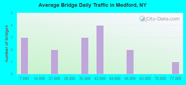
- 465,487Total average daily traffic
- 20,504Total average daily truck traffic
- National Bridge Inventory (NBI) Registered Bridges for Medford
- No street view available for this location
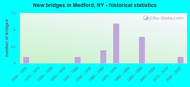
- New bridges - historical statistics
- 11900-1909
- 11940-1949
- 21960-1969
- 61970-1979
- 41990-1999
- 12020-2022
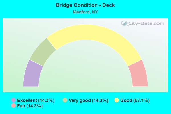
- Bridge Condition - Deck
- 14.3%Excellent
- 14.3%Very good
- 57.1%Good
- 14.3%Fair
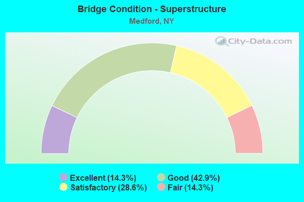
- Bridge Condition - Superstructure
- 14.3%Excellent
- 42.9%Good
- 28.6%Satisfactory
- 14.3%Fair
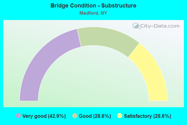
- Bridge Condition - Substructure
- 42.9%Very good
- 28.6%Good
- 28.6%Satisfactory
Find on map >> Show street view
Structure Number: 1064109, Location: 1.3 MI W JCT RTS 495+112 (Lat: 40.823311, Lng: -73.020150), Route carried "on" structure: Other road , Year Built: 1968, Year Reconstructed: 2007, Status: Open, Structure Length: 7.07m (23.20ft), Average Daily Traffic: 39,395 (year 2019), Truck Traffic: 4%, Average Future Daily Traffic: 45,453 (year 2040), Design Load: H 20, Features Intersected: 495I495I07031226, RTE I4, Facility Carried by Structure: NORTH OCEAN AVE
Minimum Vertical Clearance: 30+ m (98+ ft), Kilometerpoint: 5.084, Lanes on structure: 7, Lanes under structure: 8, Owner: State Highway Agency, Approaching Roadway Width: 28.0m (91.9ft), Material/Design: Steel, Design/Construction: Stringer/Multi-beam, Number Of Spans In Main Unit: 4, Length of Maximum Span: 23.8m (78.1ft), Curb or Sidewalk Widths: Left: 2.0m (6.6ft), Right: 2.0m (6.6ft), Curb-To-Curb Width: 27.9m (91.5ft), Out-to-Out Width: 32.3m (106.0ft)
Condition: Deck: Very good, Superstructure: Good, Substructure: Satisfactory, Operating Rating: 70.8 metric tons, Method Used To Determine Operating Rating: Load Factor (LF), Inventory Rating: 42.6 metric tons, Method Used To Determine Inventory Rating: Load Factor (LF), Structural Evaluation: Equal to present minimum criteria, Deck Geometry: Somewhat better than minimum adequacy, Underclear: High priority of corrective action, Approach Roadway Alignment: Better than present minimum criteria, Length Of Structure Improvement: 7.07m (23.20ft), Designated Inspection Frequency: Every 24 months, Inspection Date: October 2021, Bridge Improvement Cost: $8,384,000, Roadway Improvement Cost: $4,910,000, Total Project Cost: $13,293,000 ( Estimate for 2021), Deck Structure Type: Concrete Cast-file-Place, Wearing Surface/Protective System: Wearing Surface: Monolithic Concrete
Find on map >> Show street view
Structure Number: 1064111, Location: .9 MI W JCT I495 & SH112 (Lat: 40.823731, Lng: -73.013256), Route carried "on" structure: Interstate 495, Year Built: 1998, Status: Open, Structure Length: 2.16m (7.09ft), Average Daily Traffic: 38,189 (year 1998), Truck Traffic: 13%, Design Load: HS 25 or greater, Features Intersected: OLD MEDFORD AVE
Minimum Vertical Clearance: 30+ m (98+ ft), Kilometerpoint: 37.071, Lanes on structure: 4, Lanes under structure: 3, Base Highway Network: Yes, Owner: State Highway Agency, Approaching Roadway Width: 22.9m (75.1ft), Material/Design: Prestressed concrete, Design/Construction: Box Beam or Girders - Multiple, Number Of Spans In Main Unit: 1, Length of Maximum Span: 20.4m (66.9ft), Curb-To-Curb Width: 23.0m (75.5ft), Out-to-Out Width: 24.0m (78.7ft)
Condition: Deck: Good, Superstructure: Good, Substructure: Very good, Operating Rating: 89.8 metric tons, Method Used To Determine Operating Rating: Load Factor (LF), Inventory Rating: 40.8 metric tons, Method Used To Determine Inventory Rating: Load Factor (LF), Structural Evaluation: Better than present minimum criteria, Deck Geometry: Superior to present desirable criteria, Underclear: High priority of corrective action, Approach Roadway Alignment: Equal to present desirable criteria, Length Of Structure Improvement: 2.16m (7.09ft), Designated Inspection Frequency: Every 24 months, Inspection Date: October 2021, Bridge Improvement Cost: $2,967,000, Roadway Improvement Cost: $1,738,000, Total Project Cost: $4,705,000 ( Estimate for 2021), Deck Structure Type: Concrete Cast-file-Place, Wearing Surface/Protective System: Wearing Surface: Integral Concrete
Find on map >> Show street view
Structure Number: 1064112, Location: .9 MI W JCT I495 & SH 112 (Lat: 40.823503, Lng: -73.013233), Route carried "on" structure: Interstate 495, Year Built: 1998, Status: Open, Structure Length: 2.16m (7.09ft), Average Daily Traffic: 51,825 (year 2019), Truck Traffic: 6%, Average Future Daily Traffic: 54,415 (year 2040), Design Load: HS 25 or greater, Features Intersected: OLD MEDFORD AVE
Minimum Vertical Clearance: 30+ m (98+ ft), Kilometerpoint: 37.071, Lanes on structure: 4, Lanes under structure: 6, Base Highway Network: Yes, Owner: State Highway Agency, Approaching Roadway Width: 22.9m (75.1ft), Material/Design: Prestressed concrete, Design/Construction: Stringer/Multi-beam, Number Of Spans In Main Unit: 1, Length of Maximum Span: 20.4m (66.9ft), Curb-To-Curb Width: 23.0m (75.5ft), Out-to-Out Width: 24.0m (78.7ft)
Condition: Deck: Good, Superstructure: Good, Substructure: Very good, Operating Rating: 89.8 metric tons, Method Used To Determine Operating Rating: Load Factor (LF), Inventory Rating: 40.8 metric tons, Method Used To Determine Inventory Rating: Load Factor (LF), Structural Evaluation: Better than present minimum criteria, Deck Geometry: Superior to present desirable criteria, Underclear: High priority of corrective action, Approach Roadway Alignment: Equal to present desirable criteria, Length Of Structure Improvement: 2.16m (7.09ft), Designated Inspection Frequency: Every 24 months, Inspection Date: October 2021, Bridge Improvement Cost: $2,942,000, Roadway Improvement Cost: $1,723,000, Total Project Cost: $4,665,000 ( Estimate for 2021), Deck Structure Type: Concrete Cast-file-Place, Wearing Surface/Protective System: Wearing Surface: Integral Concrete
Find on map >> Show street view
Structure Number: 1064121, Location: JCT RTS 112+495 (Lat: 40.823919, Lng: -72.996619), Route carried "on" structure: Interstate 495, Year Built: 1970, Status: Open, Structure Length: 5.03m (16.50ft), Average Daily Traffic: 38,189 (year 2001), Truck Traffic: 13%, Design Load: H 20, Features Intersected: RTE 112
Minimum Vertical Clearance: 30+ m (98+ ft), Kilometerpoint: 38.455, Lanes on structure: 3, Lanes under structure: 4, Base Highway Network: Yes, Owner: State Highway Agency, Approaching Roadway Width: 12.5m (41.0ft), Skew: 2 degrees, Material/Design: Steel, Design/Construction: Stringer/Multi-beam, Number Of Spans In Main Unit: 2, Length of Maximum Span: 24.3m (79.7ft), Curb-To-Curb Width: 12.4m (40.7ft), Out-to-Out Width: 13.9m (45.6ft)
Condition: Deck: Good, Superstructure: Satisfactory, Substructure: Good, Operating Rating: 78.9 metric tons, Method Used To Determine Operating Rating: Load Factor (LF), Inventory Rating: 47.2 metric tons, Method Used To Determine Inventory Rating: Load Factor (LF), Structural Evaluation: Equal to present minimum criteria, Deck Geometry: High priority of replacement, Underclear: Meets minimum limits, Approach Roadway Alignment: Equal to present desirable criteria, Length Of Structure Improvement: 5.02m (16.47ft), Designated Inspection Frequency: Every 24 months, Inspection Date: June 2021, Bridge Improvement Cost: $2,676,000, Roadway Improvement Cost: $1,567,000, Total Project Cost: $4,243,000 ( Estimate for 2021), Deck Structure Type: Concrete Cast-file-Place, Wearing Surface/Protective System: Wearing Surface: Monolithic Concrete
Find on map >> Show street view
Structure Number: 1064122, Location: JCT RTS 112+495 (Lat: 40.823653, Lng: -72.996594), Route carried "on" structure: Interstate 495, Year Built: 1970, Status: Open, Structure Length: 5.03m (16.50ft), Average Daily Traffic: 51,825 (year 2019), Truck Traffic: 6%, Average Future Daily Traffic: 54,415 (year 2040), Design Load: H 20, Features Intersected: RTE 112
Minimum Vertical Clearance: 30+ m (98+ ft), Kilometerpoint: 38.423, Lanes on structure: 3, Lanes under structure: 4, Base Highway Network: Yes, Owner: State Highway Agency, Approaching Roadway Width: 12.2m (40.0ft), Skew: 2 degrees, Material/Design: Steel, Design/Construction: Stringer/Multi-beam, Number Of Spans In Main Unit: 2, Length of Maximum Span: 24.3m (79.7ft), Curb-To-Curb Width: 12.3m (40.4ft), Out-to-Out Width: 13.9m (45.6ft)
Condition: Deck: Good, Superstructure: Satisfactory, Substructure: Good, Operating Rating: 78.9 metric tons, Method Used To Determine Operating Rating: Load Factor (LF), Inventory Rating: 47.2 metric tons, Method Used To Determine Inventory Rating: Load Factor (LF), Structural Evaluation: Equal to present minimum criteria, Deck Geometry: High priority of replacement, Underclear: Meets minimum limits, Approach Roadway Alignment: Equal to present desirable criteria, Length Of Structure Improvement: 5.02m (16.47ft), Designated Inspection Frequency: Every 24 months, Inspection Date: June 2021, Bridge Improvement Cost: $2,645,000, Roadway Improvement Cost: $1,549,000, Total Project Cost: $4,193,000 ( Estimate for 2021), Deck Structure Type: Concrete Cast-file-Place, Wearing Surface/Protective System: Wearing Surface: Monolithic Concrete
Find on map >> Show street view
Structure Number: 1064139, Location: 1.1 MI E RTS 112+495 (Lat: 40.822322, Lng: -72.975306), Route carried "on" structure: County highway , Year Built: 1970, Year Reconstructed: 2013, Status: Open, Structure Length: 12.95m (42.49ft), Average Daily Traffic: 17,987 (year 2016), Truck Traffic: 5%, Average Future Daily Traffic: 21,850 (year 2040), Design Load: H 20, Features Intersected: 495I495I07041250, W/B, R, Facility Carried by Structure: HORSE BLOCK ROAD
Minimum Vertical Clearance: 30+ m (98+ ft), Kilometerpoint: 18.825, Lanes on structure: 5, Lanes under structure: 6, Owner: State Highway Agency, Approaching Roadway Width: 19.5m (64.0ft), Skew: 23 degrees, Material/Design: Steel, Design/Construction: Stringer/Multi-beam, Number Of Spans In Main Unit: 5, Length of Maximum Span: 33.5m (109.9ft), Curb or Sidewalk Widths: Left: 1.5m (4.9ft), Right: 1.5m (4.9ft), Curb-To-Curb Width: 19.5m (64.0ft), Out-to-Out Width: 23.2m (76.1ft)
Condition: Deck: Fair, Superstructure: Fair, Substructure: Satisfactory, Operating Rating: 35.6 metric tons, Method Used To Determine Operating Rating: Load and Resistance Factor Rating (LRFR) rating reported by rating factor(RF) method using HL-93 loadings, Inventory Rating: 27.5 metric tons, Method Used To Determine Inventory Rating: Load and Resistance Factor Rating (LRFR) rating reported by rating factor(RF) method using HL-93 loadings, Structural Evaluation: Somewhat better than minimum adequacy, Deck Geometry: Meets minimum limits, Underclear: High priority of corrective action, Approach Roadway Alignment: Equal to present desirable criteria, Length Of Structure Improvement: 12.95m (42.49ft), Designated Inspection Frequency: Every 24 months, Inspection Date: July 2021, Bridge Improvement Cost: $11,375,000, Roadway Improvement Cost: $6,661,000, Total Project Cost: $18,036,000 ( Estimate for 2021), Deck Structure Type: Concrete Cast-file-Place, Wearing Surface/Protective System: Wearing Surface: Bituminous, Membrane: Other
Find on map >> Show street view
Structure Number: 33008, Location: 1.5 MI EAST OF MEDFORD (Lat: 40.819925, Lng: -72.969372), Route carried "on" structure: County highway , Year Built: 2020, Status: Open, Structure Length: 5.03m (16.50ft), Average Daily Traffic: 20,943 (year 2018), Truck Traffic: 9%, Average Future Daily Traffic: 25,441 (year 2040), Design Load: HL 93, Features Intersected: Long Island RR, LONG ISL, Facility Carried by Structure: Horse Block Rd-CR1
Minimum Vertical Clearance: 32.69m (107.25ft), Kilometerpoint: 19.388, Lanes on structure: 2, Lanes under structure: 2, Owner: County Highway Agency, Approaching Roadway Width: 15.5m (50.9ft), Skew: 25 degrees, Material/Design: Steel continuous, Design/Construction: Stringer/Multi-beam, Number Of Spans In Main Unit: 2, Length of Maximum Span: 27.4m (89.9ft), Curb or Sidewalk Widths: Left: 1.7m (5.6ft), Right: 1.7m (5.6ft), Curb-To-Curb Width: 15.6m (51.2ft), Out-to-Out Width: 19.5m (64.0ft)
Condition: Deck: Excellent, Superstructure: Excellent, Substructure: Very good, Operating Rating: 94.3 metric tons, Method Used To Determine Operating Rating: Load Factor (LF), Inventory Rating: 56.2 metric tons, Method Used To Determine Inventory Rating: Load Factor (LF), Structural Evaluation: Equal to present desirable criteria, Deck Geometry: Superior to present desirable criteria, Underclear: Meets minimum limits, Approach Roadway Alignment: Equal to present desirable criteria, Length Of Structure Improvement: 5.02m (16.47ft), Designated Inspection Frequency: Every 24 months, Inspection Date: December 2020, Bridge Improvement Cost: $7,382,000, Roadway Improvement Cost: $4,323,000, Total Project Cost: $11,705,000 ( Estimate for 2021), Deck Structure Type: Concrete Cast-file-Place, Wearing Surface/Protective System: Wearing Surface: Integral Concrete, Deck Protection: Epoxy Coated Reinforcing
Find on map >> Show street view
Structure Number: 1064109, Location: 1.3 MI W JCT RTS 495+112 (Lat: 40.823311, Lng: -73.020150), Route carried "under" structure: Interstate 495, Year Built: 1968, Structure Length: 0. m, Average Daily Traffic: 72,500 (year 1973), Features Intersected: 495I495I07031226, RTE I4, Facility Carried by Structure: NORTH OCEAN AVE
Minimum Vertical Clearance: 5.00m (16.40ft), Kilometerpoint: 36.605, Lanes on structure: 7, Lanes under structure: 4, Material/Design: Steel, Design/Construction: Stringer/Multi-beam, Length of Maximum Span: 23.8m (78.1ft)
Find on map >> Show street view
Structure Number: 1064111, Location: .9 MI W JCT I495 & SH112 (Lat: 40.823731, Lng: -73.013256), Route carried "under" structure: Other road , Year Built: 1998, Structure Length: 0. m, Average Daily Traffic: 2,400 (year 2021), Features Intersected: OLD MEDFORD AVE, Facility Carried by Structure: RTE I495
Minimum Vertical Clearance: 5.18m (16.99ft), Kilometerpoint: 0.000, Lanes on structure: 4, Lanes under structure: 3, Material/Design: Prestressed concrete, Design/Construction: Box Beam or Girders - Multiple, Length of Maximum Span: 20.4m (66.9ft)
Find on map >> Show street view
Structure Number: 1064112, Location: .9 MI W JCT I495 & SH 112 (Lat: 40.823503, Lng: -73.013233), Route carried "under" structure: Other road , Year Built: 1998, Structure Length: 0. m, Average Daily Traffic: 2,400 (year 2021), Features Intersected: OLD MEDFORD AVE, Facility Carried by Structure: RTE I495
Minimum Vertical Clearance: 4.52m (14.83ft), Kilometerpoint: 0.000, Lanes on structure: 4, Lanes under structure: 6, Material/Design: Prestressed concrete, Design/Construction: Stringer/Multi-beam, Length of Maximum Span: 20.4m (66.9ft)
Find on map >> Show street view
Structure Number: 1064121, Location: JCT RTS 112+495 (Lat: 40.823919, Lng: -72.996619), Route carried "under" structure: State highway 112, Year Built: 1970, Structure Length: 0. m, Average Daily Traffic: 29,763 (year 2002), Features Intersected: RTE 112, Facility Carried by Structure: RTE I495
Minimum Vertical Clearance: 4.44m (14.57ft), Kilometerpoint: 6.581, Lanes on structure: 3, Lanes under structure: 4, Material/Design: Steel, Design/Construction: Stringer/Multi-beam, Length of Maximum Span: 24.3m (79.7ft)
Find on map >> Show street view
Structure Number: 1064122, Location: JCT RTS 112+495 (Lat: 40.823653, Lng: -72.996594), Route carried "under" structure: State highway 112, Year Built: 1970, Structure Length: 0. m, Average Daily Traffic: 29,763 (year 2002), Features Intersected: RTE 112, Facility Carried by Structure: RTE I495
Minimum Vertical Clearance: 4.80m (15.75ft), Kilometerpoint: 6.581, Lanes on structure: 3, Lanes under structure: 4, Material/Design: Steel, Design/Construction: Stringer/Multi-beam, Length of Maximum Span: 24.3m (79.7ft)
Find on map >> Show street view
Structure Number: 1064139, Location: 1.1 MI E RTS 112+495 (Lat: 40.822322, Lng: -72.975306), Route carried "under" structure: Interstate 495, Year Built: 1970, Structure Length: 0. m, Average Daily Traffic: 40,000 (year 1979), Features Intersected: 495I495I07041250, W/B, R, Facility Carried by Structure: HORSE BLOCK ROAD
Minimum Vertical Clearance: 4.57m (14.99ft), Kilometerpoint: 40.338, Lanes on structure: 5, Lanes under structure: 3, Material/Design: Steel, Design/Construction: Stringer/Multi-beam, Length of Maximum Span: 33.5m (109.9ft)
Find on map >> Show street view
Structure Number: 703703, Location: .5MI S JCT RTS 112+495 (Lat: 40.817308, Lng: -72.999864), Route carried "under" structure: State highway 112, Year Built: 1940, Structure Length: 0. m, Average Daily Traffic: 28,308 (year 2002), Features Intersected: RTE 112, Facility Carried by Structure: LONG ISLAND RR
Minimum Vertical Clearance: 4.27m (14.01ft), Kilometerpoint: 5.825, Lanes under structure: 4, Material/Design: Steel, Design/Construction: Girder and Floorbeam System, Length of Maximum Span: 17.0m (55.8ft)
Find on map >> Show street view
Structure Number: 770926, Location: 1.0 MI WEST OF MEDFORD (Lat: 40.816217, Lng: -73.012417), Route carried "under" structure: Other road , Year Built: 1906, Structure Length: 0. m, Average Daily Traffic: 2,000 (year 1974), Features Intersected: MEDFORD AVE, Facility Carried by Structure: LIRR MAIN LINE
Minimum Vertical Clearance: 3.09m (10.14ft), Kilometerpoint: 0.000, Lanes under structure: 2, Material/Design: Steel, Design/Construction: Stringer/Multi-beam, Length of Maximum Span: 10.0m (32.8ft)