Bridge Statistics for Middle Point, Ohio (OH)
Condition, Traffic, Stress, Structural Evaluation, Project Costs
- National Bridge Inventory (NBI) Statistics
- 36Number of bridges
- 285ft / 87.1mTotal length
- 113,270Total average daily traffic
- 35,840Total average daily truck traffic
- National Bridge Inventory (NBI) Registered Bridges for Middle Point
- No street view available for this location
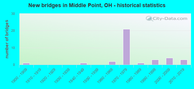
- New bridges - historical statistics
- 11900-1909
- 11940-1949
- 21960-1969
- 211970-1979
- 11980-1989
- 31990-1999
- 42000-2009
- 32010-2019
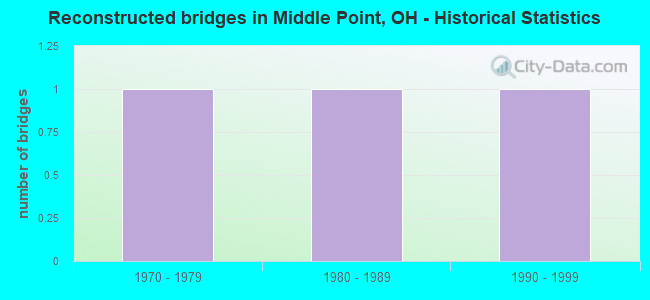
- Reconstructed bridges - Historical Statistics
- 11970-1979
- 11980-1989
- 11990-1999
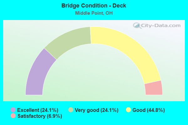
- Bridge Condition - Deck
- 24.1%Excellent
- 24.1%Very good
- 44.8%Good
- 6.9%Satisfactory
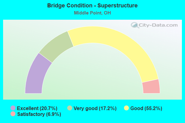
- Bridge Condition - Superstructure
- 20.7%Excellent
- 17.2%Very good
- 55.2%Good
- 6.9%Satisfactory
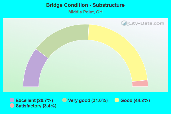
- Bridge Condition - Substructure
- 20.7%Excellent
- 31.0%Very good
- 44.8%Good
- 3.4%Satisfactory
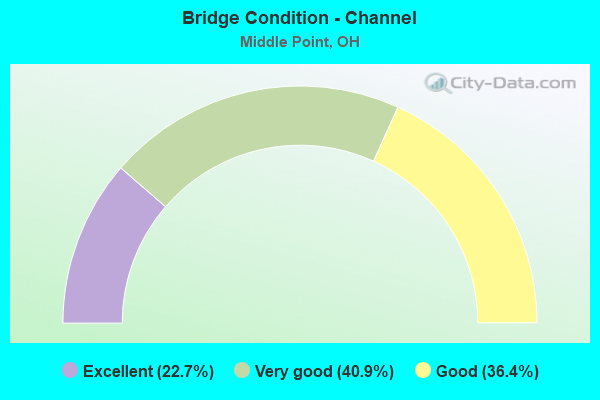
- Bridge Condition - Channel
- 22.7%Excellent
- 40.9%Very good
- 36.4%Good
Find on map >> Show street view
Structure Number: 8102775, Location: 0.29 mi W of Twp Rd 185 (Lat: 40.837419, Lng: -84.441889), Route carried "on" structure: State highway 697, Year Built: 2015, Status: Open, Structure Length: 2.78m (9.12ft), Average Daily Traffic: 1,800 (year 2015), Truck Traffic: 10%, Average Future Daily Traffic: 1,800 (year 2035), Design Load: HL 93, Features Intersected: LITTLE AUGLAIZE RIVER
Minimum Vertical Clearance: 30+ m (98+ ft), Kilometerpoint: 2.865, Lanes on structure: 2, Owner: State Highway Agency, Approaching Roadway Width: 9.1m (29.9ft), Skew: 1 degrees, Material/Design: Prestressed concrete, Design/Construction: Box Beam or Girders - Multiple, Number Of Spans In Main Unit: 1, Length of Maximum Span: 27.4m (89.9ft), Curb-To-Curb Width: 9.1m (29.9ft), Out-to-Out Width: 9.1m (29.9ft)
Condition: Deck: Excellent, Superstructure: Excellent, Substructure: Excellent, Channel: Excellent, Operating Rating: 55.1 metric tons, Method Used To Determine Operating Rating: Load and Resistance Factor Rating (LRFR) rating reported by rating factor(RF) method using HL-93 loadings, Inventory Rating: 38.9 metric tons, Method Used To Determine Inventory Rating: Load and Resistance Factor Rating (LRFR) rating reported by rating factor(RF) method using HL-93 loadings, Structural Evaluation: Superior to present desirable criteria, Deck Geometry: Somewhat better than minimum adequacy, Waterway Adequacy: Superior to present desirable criteria, Approach Roadway Alignment: Equal to present desirable criteria, Designated Inspection Frequency: Every 24 months, Inspection Date: July 2020, Deck Structure Type: Concrete Cast-file-Place, Wearing Surface/Protective System: Wearing Surface: Bituminous, Deck Protection: Epoxy Coated Reinforcing
Find on map >> Show street view
Structure Number: 8104042, Location: 5.53 mi. East of USR 127 (Lat: 40.869769, Lng: -84.485581), Route carried "on" structure: County highway T0151, Year Built: 1978, Status: Open, Structure Length: 5.94m (19.49ft), Average Daily Traffic: 324 (year 2015), Truck Traffic: 7%, Average Future Daily Traffic: 16,292 (year 2035), Design Load: HS 20+Mod, Features Intersected: USR 30, Facility Carried by Structure: TR151 CHENOWITH RD
Minimum Vertical Clearance: 30+ m (98+ ft), Kilometerpoint: 0.016, Lanes on structure: 2, Lanes under structure: 4, Owner: State Highway Agency, Approaching Roadway Width: 9.1m (29.9ft), Material/Design: Steel continuous, Design/Construction: Stringer/Multi-beam, Number Of Spans In Main Unit: 2, Length of Maximum Span: 29.0m (95.1ft), Curb-To-Curb Width: 9.3m (30.5ft), Out-to-Out Width: 10.4m (34.1ft)
Condition: Deck: Good, Superstructure: Good, Substructure: Very good, Operating Rating: 42.1 metric tons, Method Used To Determine Operating Rating: Load Factor (LF) rating reported by rating factor (RF) method using MS18 loading, Inventory Rating: 32.4 metric tons, Method Used To Determine Inventory Rating: Load Factor (LF) rating reported by rating factor (RF) method using MS18 loading, Structural Evaluation: Better than present minimum criteria, Deck Geometry: Equal to present minimum criteria, Underclear: Equal to present minimum criteria, Approach Roadway Alignment: Superior to present desirable criteria, Designated Inspection Frequency: Every 24 months, Inspection Date: August 2020, Deck Structure Type: Concrete Cast-file-Place, Wearing Surface/Protective System: Wearing Surface: Bituminous, Membrane: Built-up
Find on map >> Show street view
Structure Number: 8104077, Location: 5.62 mi. East of USR 127 (Lat: 40.869889, Lng: -84.483819), Route carried "on" structure: US 30, Year Built: 1978, Status: Open, Structure Length: 1.52m (4.99ft), Average Daily Traffic: 5,869 (year 2015), Truck Traffic: 37%, Average Future Daily Traffic: 8,146 (year 2035), Design Load: HS 20+Mod, Features Intersected: SPICE RUN
Minimum Vertical Clearance: 30+ m (98+ ft), Kilometerpoint: 29.837, Lanes on structure: 2, Base Highway Network: Yes, Owner: State Highway Agency, Approaching Roadway Width: 11.0m (36.1ft), Material/Design: Concrete continuous, Design/Construction: Slab, Number Of Spans In Main Unit: 3, Length of Maximum Span: 5.8m (19.0ft), Curb-To-Curb Width: 12.2m (40.0ft), Out-to-Out Width: 12.6m (41.3ft)
Condition: Deck: Good, Superstructure: Good, Substructure: Good, Channel: Excellent, Operating Rating: 42.1 metric tons, Method Used To Determine Operating Rating: Load Factor (LF) rating reported by rating factor (RF) method using MS18 loading, Inventory Rating: 32.4 metric tons, Method Used To Determine Inventory Rating: Load Factor (LF) rating reported by rating factor (RF) method using MS18 loading, Structural Evaluation: Better than present minimum criteria, Deck Geometry: Better than present minimum criteria, Waterway Adequacy: Superior to present desirable criteria, Approach Roadway Alignment: Superior to present desirable criteria, Designated Inspection Frequency: Every 24 months, Inspection Date: August 2020, Deck Structure Type: Concrete Cast-file-Place, Wearing Surface/Protective System: Wearing Surface: Integral Concrete
Find on map >> Show street view
Structure Number: 8104085, Location: 5.62 mi. East of USR 127 (Lat: 40.869631, Lng: -84.483839), Route carried "on" structure: US 30, Year Built: 1978, Status: Open, Structure Length: 1.52m (4.99ft), Average Daily Traffic: 5,869 (year 2015), Truck Traffic: 37%, Average Future Daily Traffic: 8,146 (year 2035), Design Load: HS 20+Mod, Features Intersected: SPICE RUN
Minimum Vertical Clearance: 30+ m (98+ ft), Kilometerpoint: 29.837, Lanes on structure: 2, Base Highway Network: Yes, Owner: State Highway Agency, Approaching Roadway Width: 11.0m (36.1ft), Material/Design: Concrete continuous, Design/Construction: Slab, Number Of Spans In Main Unit: 3, Length of Maximum Span: 5.8m (19.0ft), Curb-To-Curb Width: 12.2m (40.0ft), Out-to-Out Width: 12.6m (41.3ft)
Condition: Deck: Good, Superstructure: Good, Substructure: Good, Channel: Excellent, Operating Rating: 42.1 metric tons, Method Used To Determine Operating Rating: Load Factor (LF) rating reported by rating factor (RF) method using MS18 loading, Inventory Rating: 32.4 metric tons, Method Used To Determine Inventory Rating: Load Factor (LF) rating reported by rating factor (RF) method using MS18 loading, Structural Evaluation: Better than present minimum criteria, Deck Geometry: Better than present minimum criteria, Waterway Adequacy: Superior to present desirable criteria, Approach Roadway Alignment: Superior to present desirable criteria, Designated Inspection Frequency: Every 24 months, Inspection Date: August 2020, Deck Structure Type: Concrete Cast-file-Place, Wearing Surface/Protective System: Wearing Surface: Integral Concrete
Find on map >> Show street view
Structure Number: 8104115, Location: 6.04 mi. East of USR 127 (Lat: 40.869719, Lng: -84.475839), Route carried "on" structure: County highway T0159, Year Built: 1978, Status: Open, Structure Length: 5.94m (19.49ft), Average Daily Traffic: 213 (year 2015), Truck Traffic: 8%, Average Future Daily Traffic: 16,292 (year 2035), Design Load: HS 20+Mod, Features Intersected: USR 30, Facility Carried by Structure: TR 159 RINGWALD RD
Minimum Vertical Clearance: 30+ m (98+ ft), Kilometerpoint: 0.032, Lanes on structure: 2, Lanes under structure: 4, Owner: State Highway Agency, Approaching Roadway Width: 9.1m (29.9ft), Material/Design: Steel continuous, Design/Construction: Stringer/Multi-beam, Number Of Spans In Main Unit: 2, Length of Maximum Span: 29.0m (95.1ft), Curb-To-Curb Width: 9.3m (30.5ft), Out-to-Out Width: 10.4m (34.1ft)
Condition: Deck: Very good, Superstructure: Good, Substructure: Very good, Operating Rating: 42.1 metric tons, Method Used To Determine Operating Rating: Load Factor (LF) rating reported by rating factor (RF) method using MS18 loading, Inventory Rating: 32.4 metric tons, Method Used To Determine Inventory Rating: Load Factor (LF) rating reported by rating factor (RF) method using MS18 loading, Structural Evaluation: Better than present minimum criteria, Deck Geometry: Equal to present minimum criteria, Underclear: Equal to present minimum criteria, Approach Roadway Alignment: Superior to present desirable criteria, Designated Inspection Frequency: Every 24 months, Inspection Date: August 2020, Deck Structure Type: Concrete Cast-file-Place, Wearing Surface/Protective System: Wearing Surface: Bituminous, Membrane: Built-up
Find on map >> Show street view
Structure Number: 8104158, Location: 6.20 mi. East of USR 127 (Lat: 40.869831, Lng: -84.470861), Route carried "on" structure: US 30, Year Built: 1978, Status: Open, Structure Length: 1.62m (5.31ft), Average Daily Traffic: 5,869 (year 2015), Truck Traffic: 37%, Average Future Daily Traffic: 8,146 (year 2035), Design Load: HS 20+Mod, Features Intersected: DOG CREEK
Minimum Vertical Clearance: 30+ m (98+ ft), Kilometerpoint: 30.915, Lanes on structure: 2, Base Highway Network: Yes, Owner: State Highway Agency, Approaching Roadway Width: 11.0m (36.1ft), Skew: 3 degrees, Material/Design: Concrete continuous, Design/Construction: Slab, Number Of Spans In Main Unit: 2, Length of Maximum Span: 7.6m (24.9ft), Curb-To-Curb Width: 12.2m (40.0ft), Out-to-Out Width: 12.6m (41.3ft)
Condition: Deck: Good, Superstructure: Good, Substructure: Good, Channel: Very good, Operating Rating: 42.1 metric tons, Method Used To Determine Operating Rating: Load Factor (LF) rating reported by rating factor (RF) method using MS18 loading, Inventory Rating: 32.4 metric tons, Method Used To Determine Inventory Rating: Load Factor (LF) rating reported by rating factor (RF) method using MS18 loading, Structural Evaluation: Better than present minimum criteria, Deck Geometry: Better than present minimum criteria, Waterway Adequacy: Superior to present desirable criteria, Approach Roadway Alignment: Superior to present desirable criteria, Designated Inspection Frequency: Every 24 months, Inspection Date: September 2020, Deck Structure Type: Concrete Cast-file-Place, Wearing Surface/Protective System: Wearing Surface: Integral Concrete
Find on map >> Show street view
Structure Number: 8104166, Location: 6.20 mi. East of USR 127 (Lat: 40.869581, Lng: -84.471050), Route carried "on" structure: US 30, Year Built: 1978, Status: Open, Structure Length: 1.62m (5.31ft), Average Daily Traffic: 5,869 (year 2015), Truck Traffic: 37%, Average Future Daily Traffic: 8,146 (year 2035), Design Load: HS 20+Mod, Features Intersected: DOG CREEK
Minimum Vertical Clearance: 30+ m (98+ ft), Kilometerpoint: 30.915, Lanes on structure: 2, Base Highway Network: Yes, Owner: State Highway Agency, Approaching Roadway Width: 11.0m (36.1ft), Skew: 3 degrees, Material/Design: Concrete continuous, Design/Construction: Slab, Number Of Spans In Main Unit: 2, Length of Maximum Span: 7.6m (24.9ft), Curb-To-Curb Width: 12.2m (40.0ft), Out-to-Out Width: 12.6m (41.3ft)
Condition: Deck: Good, Superstructure: Good, Substructure: Good, Channel: Very good, Operating Rating: 42.1 metric tons, Method Used To Determine Operating Rating: Load Factor (LF) rating reported by rating factor (RF) method using MS18 loading, Inventory Rating: 32.4 metric tons, Method Used To Determine Inventory Rating: Load Factor (LF) rating reported by rating factor (RF) method using MS18 loading, Structural Evaluation: Better than present minimum criteria, Deck Geometry: Better than present minimum criteria, Waterway Adequacy: Superior to present desirable criteria, Approach Roadway Alignment: Superior to present desirable criteria, Designated Inspection Frequency: Every 24 months, Inspection Date: September 2020, Deck Structure Type: Concrete Cast-file-Place, Wearing Surface/Protective System: Wearing Surface: Integral Concrete
Find on map >> Show street view
Structure Number: 810419, Location: 7.04 mi. East of USR 127 (Lat: 40.869850, Lng: -84.456781), Route carried "on" structure: US 30, Year Built: 1978, Status: Open, Structure Length: 2.90m (9.51ft), Average Daily Traffic: 5,869 (year 2015), Truck Traffic: 37%, Average Future Daily Traffic: 8,146 (year 2035), Design Load: HS 20+Mod, Features Intersected: CR 173
Minimum Vertical Clearance: 30+ m (98+ ft), Kilometerpoint: 32.123, Lanes on structure: 2, Lanes under structure: 2, Base Highway Network: Yes, Owner: State Highway Agency, Approaching Roadway Width: 11.0m (36.1ft), Material/Design: Concrete continuous, Design/Construction: Slab, Number Of Spans In Main Unit: 2, Length of Maximum Span: 11.0m (36.1ft), Curb-To-Curb Width: 12.2m (40.0ft), Out-to-Out Width: 12.8m (42.0ft)
Condition: Deck: Good, Superstructure: Good, Substructure: Very good, Operating Rating: 42.1 metric tons, Method Used To Determine Operating Rating: Load Factor (LF) rating reported by rating factor (RF) method using MS18 loading, Inventory Rating: 32.4 metric tons, Method Used To Determine Inventory Rating: Load Factor (LF) rating reported by rating factor (RF) method using MS18 loading, Structural Evaluation: Better than present minimum criteria, Deck Geometry: Better than present minimum criteria, Underclear: Meets minimum limits, Approach Roadway Alignment: Superior to present desirable criteria, Designated Inspection Frequency: Every 24 months, Inspection Date: September 2020, Deck Structure Type: Concrete Cast-file-Place, Wearing Surface/Protective System: Wearing Surface: Integral Concrete
Find on map >> Show street view
Structure Number: 8104204, Location: 7.04 mi. East of USR 127 (Lat: 40.869611, Lng: -84.456789), Route carried "on" structure: US 30, Year Built: 1978, Status: Open, Structure Length: 2.90m (9.51ft), Average Daily Traffic: 5,869 (year 2015), Truck Traffic: 37%, Average Future Daily Traffic: 8,146 (year 2035), Design Load: HS 20+Mod, Features Intersected: CR 173
Minimum Vertical Clearance: 30+ m (98+ ft), Kilometerpoint: 32.123, Lanes on structure: 2, Lanes under structure: 2, Base Highway Network: Yes, Owner: State Highway Agency, Approaching Roadway Width: 11.0m (36.1ft), Material/Design: Concrete continuous, Design/Construction: Slab, Number Of Spans In Main Unit: 3, Length of Maximum Span: 11.0m (36.1ft), Curb-To-Curb Width: 12.2m (40.0ft), Out-to-Out Width: 12.8m (42.0ft)
Condition: Deck: Good, Superstructure: Good, Substructure: Very good, Operating Rating: 42.1 metric tons, Method Used To Determine Operating Rating: Load Factor (LF) rating reported by rating factor (RF) method using MS18 loading, Inventory Rating: 32.4 metric tons, Method Used To Determine Inventory Rating: Load Factor (LF) rating reported by rating factor (RF) method using MS18 loading, Structural Evaluation: Better than present minimum criteria, Deck Geometry: Better than present minimum criteria, Underclear: Meets minimum limits, Approach Roadway Alignment: Superior to present desirable criteria, Designated Inspection Frequency: Every 24 months, Inspection Date: September 2020, Deck Structure Type: Concrete Cast-file-Place, Wearing Surface/Protective System: Wearing Surface: Integral Concrete
Find on map >> Show street view
Structure Number: 8104239, Location: 7.22 mi. East of USR 127 (Lat: 40.872239, Lng: -84.448789), Route carried "on" structure: County highway C0418, Year Built: 1978, Status: Open, Structure Length: 14.08m (46.19ft), Average Daily Traffic: 1,882 (year 2015), Truck Traffic: 3%, Average Future Daily Traffic: 16,292 (year 2035), Design Load: HS 20+Mod, Features Intersected: USR 30, Facility Carried by Structure: CR 418 OLD 30
Minimum Vertical Clearance: 30+ m (98+ ft), Kilometerpoint: 0.241, Lanes on structure: 2, Lanes under structure: 4, Owner: State Highway Agency, Approaching Roadway Width: 12.2m (40.0ft), Skew: 6 degrees, Material/Design: Steel continuous, Design/Construction: Stringer/Multi-beam, Number Of Spans In Main Unit: 4, Length of Maximum Span: 43.0m (141.1ft), Curb-To-Curb Width: 12.2m (40.0ft), Out-to-Out Width: 12.8m (42.0ft)
Condition: Deck: Very good, Superstructure: Very good, Substructure: Good, Operating Rating: 42.1 metric tons, Method Used To Determine Operating Rating: Load Factor (LF) rating reported by rating factor (RF) method using MS18 loading, Inventory Rating: 32.4 metric tons, Method Used To Determine Inventory Rating: Load Factor (LF) rating reported by rating factor (RF) method using MS18 loading, Structural Evaluation: Better than present minimum criteria, Deck Geometry: Better than present minimum criteria, Underclear: Somewhat better than minimum adequacy, Approach Roadway Alignment: Superior to present desirable criteria, Designated Inspection Frequency: Every 24 months, Inspection Date: September 2020, Deck Structure Type: Concrete Cast-file-Place, Wearing Surface/Protective System: Wearing Surface: Bituminous, Membrane: Built-up
Find on map >> Show street view
Structure Number: 8104263, Location: 8.78 mi. East of USR 127 (Lat: 40.873250, Lng: -84.436439), Route carried "on" structure: County highway C0185, Year Built: 1978, Status: Open, Structure Length: 6.68m (21.92ft), Average Daily Traffic: 1,320 (year 2015), Truck Traffic: 8%, Average Future Daily Traffic: 15,654 (year 2035), Design Load: HS 20+Mod, Features Intersected: USR 30, Facility Carried by Structure: CR 185 MIDDLEPOINT
Minimum Vertical Clearance: 30+ m (98+ ft), Kilometerpoint: 0.129, Lanes on structure: 2, Lanes under structure: 4, Owner: State Highway Agency, Approaching Roadway Width: 12.2m (40.0ft), Material/Design: Steel continuous, Design/Construction: Stringer/Multi-beam, Number Of Spans In Main Unit: 2, Length of Maximum Span: 32.9m (107.9ft), Curb-To-Curb Width: 12.2m (40.0ft), Out-to-Out Width: 12.8m (42.0ft)
Condition: Deck: Very good, Superstructure: Good, Substructure: Good, Operating Rating: 42.1 metric tons, Method Used To Determine Operating Rating: Load Factor (LF) rating reported by rating factor (RF) method using MS18 loading, Inventory Rating: 32.4 metric tons, Method Used To Determine Inventory Rating: Load Factor (LF) rating reported by rating factor (RF) method using MS18 loading, Structural Evaluation: Better than present minimum criteria, Deck Geometry: Better than present minimum criteria, Underclear: Equal to present minimum criteria, Approach Roadway Alignment: Superior to present desirable criteria, Designated Inspection Frequency: Every 24 months, Inspection Date: September 2020, Deck Structure Type: Concrete Cast-file-Place, Wearing Surface/Protective System: Wearing Surface: Bituminous, Membrane: Built-up
Find on map >> Show street view
Structure Number: 8104379, Location: 9.15 mi. East of USR 127 (Lat: 40.873289, Lng: -84.417431), Route carried "on" structure: County highway T0197, Year Built: 1978, Status: Open, Structure Length: 5.94m (19.49ft), Average Daily Traffic: 60 (year 2015), Truck Traffic: 8%, Average Future Daily Traffic: 16,834 (year 2035), Design Load: HS 20+Mod, Features Intersected: USR 30, Facility Carried by Structure: TR 197 CONVERSE
Minimum Vertical Clearance: 30+ m (98+ ft), Kilometerpoint: 0.177, Lanes on structure: 2, Lanes under structure: 4, Owner: State Highway Agency, Approaching Roadway Width: 9.8m (32.2ft), Material/Design: Steel continuous, Design/Construction: Stringer/Multi-beam, Number Of Spans In Main Unit: 2, Length of Maximum Span: 29.0m (95.1ft), Curb-To-Curb Width: 9.8m (32.2ft), Out-to-Out Width: 10.4m (34.1ft)
Condition: Deck: Very good, Superstructure: Good, Substructure: Very good, Operating Rating: 42.1 metric tons, Method Used To Determine Operating Rating: Allowable Stress (AS) rating reported by rating factor (RF) method using MS18 loading, Inventory Rating: 32.4 metric tons, Method Used To Determine Inventory Rating: Allowable Stress (AS) rating reported by rating factor (RF) method using MS18 loading, Structural Evaluation: Better than present minimum criteria, Deck Geometry: Equal to present desirable criteria, Underclear: Equal to present minimum criteria, Approach Roadway Alignment: Superior to present desirable criteria, Designated Inspection Frequency: Every 24 months, Inspection Date: July 2020, Deck Structure Type: Concrete Cast-file-Place, Wearing Surface/Protective System: Wearing Surface: Bituminous, Membrane: Built-up
Find on map >> Show street view
Structure Number: 8133107, Location: 0.35 MI W JCT C 185 (Lat: 40.903081, Lng: -84.443800), Route carried "on" structure: County highway C0156, Year Built: 1989, Status: Open, Structure Length: 1.92m (6.30ft), Average Daily Traffic: 156 (year 2018), Truck Traffic: 3%, Average Future Daily Traffic: 217 (year 2038), Design Load: HS 20+Mod, Features Intersected: DOG CREEK, Facility Carried by Structure: CHURCH ROAD
Minimum Vertical Clearance: 30+ m (98+ ft), Kilometerpoint: 0.193, Lanes on structure: 2, Owner: County Highway Agency, Approaching Roadway Width: 6.4m (21.0ft), Skew: 1 degrees, Material/Design: Prestressed concrete, Design/Construction: Box Beam or Girders - Multiple, Number Of Spans In Main Unit: 1, Length of Maximum Span: 18.3m (60.0ft), Curb-To-Curb Width: 7.3m (24.0ft), Out-to-Out Width: 7.3m (24.0ft)
Condition: Deck: Very good, Superstructure: Very good, Substructure: Very good, Channel: Very good, Operating Rating: 68.0 metric tons, Method Used To Determine Operating Rating: Load Factor (LF) rating reported by rating factor (RF) method using MS18 loading, Inventory Rating: 38.9 metric tons, Method Used To Determine Inventory Rating: Load Factor (LF) rating reported by rating factor (RF) method using MS18 loading, Structural Evaluation: Equal to present desirable criteria, Deck Geometry: Somewhat better than minimum adequacy, Waterway Adequacy: Equal to present desirable criteria, Approach Roadway Alignment: Equal to present desirable criteria, Designated Inspection Frequency: Every 24 months, Inspection Date: October 2020, Deck Structure Type: Concrete Cast-file-Place, Wearing Surface/Protective System: Wearing Surface: Bituminous, Membrane: Preformed Fabric
Find on map >> Show street view
Structure Number: 8133182, Location: 0.45 MI W JCT C 185 (Lat: 40.917569, Lng: -84.446869), Route carried "on" structure: County highway C0168, Year Built: 1992, Status: Open, Structure Length: 2.11m (6.92ft), Average Daily Traffic: 299 (year 2017), Truck Traffic: 5%, Average Future Daily Traffic: 329 (year 2037), Design Load: HS 20+Mod, Features Intersected: DOG CREEK, Facility Carried by Structure: CONVOY ROAD
Minimum Vertical Clearance: 30+ m (98+ ft), Kilometerpoint: 0.579, Lanes on structure: 2, Owner: County Highway Agency, Approaching Roadway Width: 6.0m (19.7ft), Skew: 1 degrees, Material/Design: Prestressed concrete, Design/Construction: Box Beam or Girders - Multiple, Number Of Spans In Main Unit: 1, Length of Maximum Span: 19.8m (65.0ft), Curb-To-Curb Width: 8.5m (27.9ft), Out-to-Out Width: 8.5m (27.9ft)
Condition: Deck: Very good, Superstructure: Very good, Substructure: Very good, Channel: Very good, Operating Rating: 64.8 metric tons, Method Used To Determine Operating Rating: Load Factor (LF) rating reported by rating factor (RF) method using MS18 loading, Inventory Rating: 38.9 metric tons, Method Used To Determine Inventory Rating: Load Factor (LF) rating reported by rating factor (RF) method using MS18 loading, Structural Evaluation: Equal to present desirable criteria, Deck Geometry: Equal to present minimum criteria, Waterway Adequacy: Equal to present desirable criteria, Approach Roadway Alignment: Equal to present desirable criteria, Designated Inspection Frequency: Every 24 months, Inspection Date: October 2020, Deck Structure Type: Concrete Cast-file-Place, Wearing Surface/Protective System: Wearing Surface: Bituminous, Membrane: Built-up
Find on map >> Show street view
Structure Number: 8136263, Location: 0.5 Mile East Gamble Rd. (Lat: 40.830019, Lng: -84.496111), Route carried "on" structure: County highway T0098, Year Built: 2016, Status: Open, Structure Length: 1.04m (3.41ft), Average Daily Traffic: 49 (year 2018), Truck Traffic: 4%, Average Future Daily Traffic: 68 (year 2038), Design Load: HS 20+Mod, Features Intersected: Pup Creek, Facility Carried by Structure: RANK ROAD
Minimum Vertical Clearance: 30+ m (98+ ft), Kilometerpoint: 0.016, Lanes on structure: 2, Owner: County Highway Agency, Approaching Roadway Width: 4.0m (13.1ft), Material/Design: Concrete, Design/Construction: Box Beam or Girders - Multiple, Number Of Spans In Main Unit: 1, Length of Maximum Span: 9.4m (30.8ft), Curb-To-Curb Width: 7.3m (24.0ft), Out-to-Out Width: 7.3m (24.0ft)
Condition: Deck: Excellent, Superstructure: Excellent, Substructure: Excellent, Channel: Excellent, Operating Rating: 97.2 metric tons, Method Used To Determine Operating Rating: Load Factor (LF) rating reported by rating factor (RF) method using MS18 loading, Inventory Rating: 74.5 metric tons, Method Used To Determine Inventory Rating: Load Factor (LF) rating reported by rating factor (RF) method using MS18 loading, Structural Evaluation: Superior to present desirable criteria, Deck Geometry: Equal to present minimum criteria, Waterway Adequacy: Equal to present desirable criteria, Approach Roadway Alignment: Equal to present desirable criteria, Designated Inspection Frequency: Every 24 months, Inspection Date: October 2020, Deck Structure Type: Concrete Cast-file-Place, Wearing Surface/Protective System: Wearing Surface: Bituminous, Membrane: Preformed Fabric
Find on map >> Show street view
Structure Number: 8136351, Location: 2.30 MI W JCT C 173 (Lat: 40.851831, Lng: -84.501119), Route carried "on" structure: County highway C0124, Year Built: 1962, Year Reconstructed: 1992, Status: Open, Structure Length: 1.05m (3.44ft), Average Daily Traffic: 1,614 (year 2018), Truck Traffic: 6%, Average Future Daily Traffic: 2,240 (year 2038), Design Load: HS 20+Mod, Features Intersected: DOG CREEK, Facility Carried by Structure: MIDDLE POINT ROAD
Minimum Vertical Clearance: 30+ m (98+ ft), Kilometerpoint: 0.113, Lanes on structure: 2, Owner: County Highway Agency, Approaching Roadway Width: 6.9m (22.6ft), Skew: 3 degrees, Material/Design: Prestressed concrete, Design/Construction: Box Beam or Girders - Multiple, Number Of Spans In Main Unit: 1, Length of Maximum Span: 10.2m (33.5ft), Curb-To-Curb Width: 8.5m (27.9ft), Out-to-Out Width: 8.5m (27.9ft)
Condition: Deck: Good, Superstructure: Good, Substructure: Good, Channel: Good, Operating Rating: 77.8 metric tons, Method Used To Determine Operating Rating: Load Factor (LF) rating reported by rating factor (RF) method using MS18 loading, Inventory Rating: 45.4 metric tons, Method Used To Determine Inventory Rating: Load Factor (LF) rating reported by rating factor (RF) method using MS18 loading, Structural Evaluation: Better than present minimum criteria, Deck Geometry: Somewhat better than minimum adequacy, Waterway Adequacy: Somewhat better than minimum adequacy, Approach Roadway Alignment: Equal to present desirable criteria, Designated Inspection Frequency: Every 24 months, Inspection Date: October 2020, Deck Structure Type: Concrete Cast-file-Place, Wearing Surface/Protective System: Wearing Surface: Bituminous, Membrane: Preformed Fabric
Find on map >> Show street view
Structure Number: 8136416, Location: .25 MI.E. OF RINGWALD RD. (Lat: 40.866361, Lng: -84.471861), Route carried "on" structure: County highway T0138, Year Built: 2001, Status: Open, Structure Length: 2.08m (6.82ft), Average Daily Traffic: 77 (year 2018), Average Future Daily Traffic: 107 (year 2038), Design Load: HS 20+Mod, Features Intersected: DOG CREEK, Facility Carried by Structure: KNITTLE ROAD
Minimum Vertical Clearance: 30+ m (98+ ft), Kilometerpoint: 0.032, Lanes on structure: 2, Owner: County Highway Agency, Approaching Roadway Width: 3.8m (12.5ft), Skew: 2 degrees, Material/Design: Prestressed concrete, Design/Construction: Box Beam or Girders - Multiple, Number Of Spans In Main Unit: 1, Length of Maximum Span: 19.8m (65.0ft), Curb-To-Curb Width: 7.3m (24.0ft), Out-to-Out Width: 7.3m (24.0ft)
Condition: Deck: Excellent, Superstructure: Excellent, Substructure: Excellent, Channel: Very good, Operating Rating: 71.3 metric tons, Method Used To Determine Operating Rating: Load Factor (LF) rating reported by rating factor (RF) method using MS18 loading, Inventory Rating: 42.1 metric tons, Method Used To Determine Inventory Rating: Load Factor (LF) rating reported by rating factor (RF) method using MS18 loading, Structural Evaluation: Superior to present desirable criteria, Deck Geometry: Equal to present minimum criteria, Waterway Adequacy: Superior to present desirable criteria, Approach Roadway Alignment: Equal to present minimum criteria, Designated Inspection Frequency: Every 24 months, Inspection Date: October 2020, Deck Structure Type: Concrete Cast-file-Place, Wearing Surface/Protective System: Wearing Surface: Bituminous, Membrane: Preformed Fabric
Find on map >> Show street view
Structure Number: 8136483, Location: .5 MI. S. OF CO. RD. 124 (Lat: 40.844500, Lng: -84.504711), Route carried "on" structure: County highway T0139, Year Built: 2002, Status: Open, Structure Length: 1.77m (5.81ft), Average Daily Traffic: 138 (year 2018), Truck Traffic: 4%, Average Future Daily Traffic: 192 (year 2038), Design Load: HS 20+Mod, Features Intersected: DOG CREEK, Facility Carried by Structure: GAMBLE ROAD
Minimum Vertical Clearance: 30+ m (98+ ft), Kilometerpoint: 0.048, Lanes on structure: 2, Owner: County Highway Agency, Approaching Roadway Width: 5.0m (16.4ft), Material/Design: Prestressed concrete, Design/Construction: Box Beam or Girders - Multiple, Number Of Spans In Main Unit: 1, Length of Maximum Span: 16.8m (55.1ft), Curb-To-Curb Width: 7.3m (24.0ft), Out-to-Out Width: 7.3m (24.0ft)
Condition: Deck: Excellent, Superstructure: Excellent, Substructure: Excellent, Channel: Very good, Operating Rating: 77.8 metric tons, Method Used To Determine Operating Rating: Load Factor (LF) rating reported by rating factor (RF) method using MS18 loading, Inventory Rating: 45.4 metric tons, Method Used To Determine Inventory Rating: Load Factor (LF) rating reported by rating factor (RF) method using MS18 loading, Structural Evaluation: Superior to present desirable criteria, Deck Geometry: Somewhat better than minimum adequacy, Waterway Adequacy: Superior to present desirable criteria, Approach Roadway Alignment: Equal to present minimum criteria, Designated Inspection Frequency: Every 24 months, Inspection Date: October 2020, Deck Structure Type: Concrete Cast-file-Place, Wearing Surface/Protective System: Wearing Surface: Bituminous, Membrane: Preformed Fabric
Find on map >> Show street view
Structure Number: 8136513, Location: 0.92 MI N JCT C 124 (Lat: 40.873100, Lng: -84.485589), Route carried "on" structure: County highway T0151, Year Built: 1969, Status: Open, Structure Length: 1.13m (3.71ft), Average Daily Traffic: 92 (year 2018), Truck Traffic: 2%, Average Future Daily Traffic: 128 (year 2038), Design Load: HS 20, Features Intersected: SPICE RUN, Facility Carried by Structure: CHENOWITH ROAD
Minimum Vertical Clearance: 30+ m (98+ ft), Kilometerpoint: 0.032, Lanes on structure: 2, Owner: County Highway Agency, Approaching Roadway Width: 5.5m (18.0ft), Skew: 1 degrees, Material/Design: Prestressed concrete, Design/Construction: Box Beam or Girders - Multiple, Number Of Spans In Main Unit: 1, Length of Maximum Span: 10.7m (35.1ft), Curb-To-Curb Width: 7.3m (24.0ft), Out-to-Out Width: 7.3m (24.0ft)
Condition: Deck: Good, Superstructure: Good, Substructure: Good, Channel: Good, Operating Rating: 84.2 metric tons, Method Used To Determine Operating Rating: Load Factor (LF) rating reported by rating factor (RF) method using MS18 loading, Inventory Rating: 51.8 metric tons, Method Used To Determine Inventory Rating: Load Factor (LF) rating reported by rating factor (RF) method using MS18 loading, Structural Evaluation: Better than present minimum criteria, Deck Geometry: Equal to present minimum criteria, Waterway Adequacy: Equal to present desirable criteria, Approach Roadway Alignment: Equal to present desirable criteria, Designated Inspection Frequency: Every 24 months, Inspection Date: October 2020, Deck Structure Type: Concrete Cast-file-Place, Wearing Surface/Protective System: Wearing Surface: Bituminous
Find on map >> Show street view
Structure Number: 8136521, Location: 1.47 MI N JCT C 124 (Lat: 40.864681, Lng: -84.485489), Route carried "on" structure: County highway T0151, Year Built: 1991, Status: Open, Structure Length: 1.60m (5.25ft), Average Daily Traffic: 93 (year 2018), Truck Traffic: 2%, Average Future Daily Traffic: 129 (year 2038), Design Load: HS 20+Mod, Features Intersected: DOG CREEK, Facility Carried by Structure: CHENOWITH ROAD
Minimum Vertical Clearance: 30+ m (98+ ft), Kilometerpoint: 0.016, Lanes on structure: 2, Owner: County Highway Agency, Approaching Roadway Width: 4.9m (16.1ft), Skew: 1 degrees, Material/Design: Prestressed concrete, Design/Construction: Box Beam or Girders - Multiple, Number Of Spans In Main Unit: 1, Length of Maximum Span: 15.2m (49.9ft), Curb-To-Curb Width: 7.3m (24.0ft), Out-to-Out Width: 7.3m (24.0ft)
Condition: Deck: Good, Superstructure: Good, Substructure: Good, Channel: Good, Operating Rating: 71.3 metric tons, Method Used To Determine Operating Rating: Load Factor (LF) rating reported by rating factor (RF) method using MS18 loading, Inventory Rating: 42.1 metric tons, Method Used To Determine Inventory Rating: Load Factor (LF) rating reported by rating factor (RF) method using MS18 loading, Structural Evaluation: Better than present minimum criteria, Deck Geometry: Equal to present minimum criteria, Waterway Adequacy: Equal to present desirable criteria, Approach Roadway Alignment: Equal to present desirable criteria, Designated Inspection Frequency: Every 24 months, Inspection Date: October 2020, Deck Structure Type: Concrete Cast-file-Place, Wearing Surface/Protective System: Wearing Surface: Bituminous, Membrane: Preformed Fabric
Find on map >> Show street view
Structure Number: 8136548, Location: 2.05 MI N JCT SR116&697 (Lat: 40.866450, Lng: -84.475781), Route carried "on" structure: County highway T0159, Year Built: 1900, Year Reconstructed: 1981, Status: Open, Structure Length: 1.46m (4.79ft), Average Daily Traffic: 327 (year 2018), Truck Traffic: 2%, Average Future Daily Traffic: 454 (year 2038), Design Load: HS 20+Mod, Features Intersected: DOG CREEK, Facility Carried by Structure: RINGWALD ROAD
Minimum Vertical Clearance: 30+ m (98+ ft), Kilometerpoint: 0.032, Lanes on structure: 2, Owner: County Highway Agency, Approaching Roadway Width: 5.3m (17.4ft), Material/Design: Prestressed concrete, Design/Construction: Box Beam or Girders - Multiple, Number Of Spans In Main Unit: 1, Length of Maximum Span: 13.7m (44.9ft), Curb-To-Curb Width: 7.3m (24.0ft), Out-to-Out Width: 7.3m (24.0ft)
Condition: Deck: Good, Superstructure: Good, Substructure: Good, Channel: Good, Operating Rating: 71.3 metric tons, Method Used To Determine Operating Rating: Load Factor (LF) rating reported by rating factor (RF) method using MS18 loading, Inventory Rating: 42.1 metric tons, Method Used To Determine Inventory Rating: Load Factor (LF) rating reported by rating factor (RF) method using MS18 loading, Structural Evaluation: Better than present minimum criteria, Deck Geometry: Somewhat better than minimum adequacy, Waterway Adequacy: Equal to present desirable criteria, Approach Roadway Alignment: Equal to present desirable criteria, Designated Inspection Frequency: Every 24 months, Inspection Date: October 2020, Deck Structure Type: Concrete Cast-file-Place, Wearing Surface/Protective System: Wearing Surface: Bituminous
Find on map >> Show street view
Structure Number: 8136602, Location: 0.2 MI. S. CR.418 (Lat: 40.871700, Lng: -84.456519), Route carried "on" structure: County highway C0173, Year Built: 2000, Status: Open, Structure Length: 2.23m (7.32ft), Average Daily Traffic: 319 (year 2016), Truck Traffic: 3%, Average Future Daily Traffic: 443 (year 2036), Design Load: HS 20+Mod, Features Intersected: DOG CREEK, Facility Carried by Structure: DOG CREEK ROAD
Minimum Vertical Clearance: 30+ m (98+ ft), Kilometerpoint: 0.064, Lanes on structure: 2, Owner: County Highway Agency, Approaching Roadway Width: 6.6m (21.7ft), Skew: 2 degrees, Material/Design: Prestressed concrete, Design/Construction: Box Beam or Girders - Multiple, Number Of Spans In Main Unit: 1, Length of Maximum Span: 21.3m (69.9ft), Curb-To-Curb Width: 8.5m (27.9ft), Out-to-Out Width: 8.5m (27.9ft)
Condition: Deck: Excellent, Superstructure: Excellent, Substructure: Excellent, Channel: Very good, Operating Rating: 58.3 metric tons, Method Used To Determine Operating Rating: Load Factor (LF) rating reported by rating factor (RF) method using MS18 loading, Inventory Rating: 35.6 metric tons, Method Used To Determine Inventory Rating: Load Factor (LF) rating reported by rating factor (RF) method using MS18 loading, Structural Evaluation: Superior to present desirable criteria, Deck Geometry: Equal to present minimum criteria, Waterway Adequacy: Equal to present desirable criteria, Approach Roadway Alignment: Equal to present desirable criteria, Designated Inspection Frequency: Every 24 months, Inspection Date: October 2020, Deck Structure Type: Concrete Cast-file-Place, Wearing Surface/Protective System: Wearing Surface: Bituminous, Membrane: Built-up
Find on map >> Show street view
Structure Number: 8137137, Location: 0.70 MI E JCT C 173 (Lat: 40.851931, Lng: -84.442881), Route carried "on" structure: County highway C0124, Year Built: 1973, Status: Open, Structure Length: 2.97m (9.74ft), Average Daily Traffic: 1,614 (year 2018), Truck Traffic: 2%, Average Future Daily Traffic: 2,240 (year 2038), Design Load: HS 20+Mod, Features Intersected: LITTLE AUGLAIZE RIVER, Facility Carried by Structure: MIDDLE POINT R0AD
Minimum Vertical Clearance: 30+ m (98+ ft), Kilometerpoint: 0.225, Lanes on structure: 2, Owner: County Highway Agency, Approaching Roadway Width: 5.9m (19.4ft), Material/Design: Concrete continuous, Design/Construction: Slab, Number Of Spans In Main Unit: 3, Length of Maximum Span: 10.8m (35.4ft), Curb-To-Curb Width: 7.3m (24.0ft), Out-to-Out Width: 7.3m (24.0ft)
Condition: Deck: Satisfactory, Superstructure: Satisfactory, Substructure: Satisfactory, Channel: Good, Operating Rating: 94.0 metric tons, Method Used To Determine Operating Rating: Load Factor (LF) rating reported by rating factor (RF) method using MS18 loading, Inventory Rating: 55.1 metric tons, Method Used To Determine Inventory Rating: Load Factor (LF) rating reported by rating factor (RF) method using MS18 loading, Structural Evaluation: Equal to present minimum criteria, Deck Geometry: Meets minimum limits, Waterway Adequacy: Superior to present desirable criteria, Approach Roadway Alignment: Equal to present desirable criteria, Designated Inspection Frequency: Every 12 months, Inspection Date: October 2021, Deck Structure Type: Concrete Cast-file-Place, Wearing Surface/Protective System: Wearing Surface: Monolithic Concrete
Find on map >> Show street view
Structure Number: 8137196, Location: .1 MI.E. OF DOG CREEK RD. (Lat: 40.888269, Lng: -84.451600), Route carried "on" structure: County highway T0150, Year Built: 2001, Status: Open, Structure Length: 1.77m (5.81ft), Average Daily Traffic: 74 (year 2016), Truck Traffic: 7%, Average Future Daily Traffic: 103 (year 2036), Design Load: HS 20+Mod, Features Intersected: DOG CREEK, Facility Carried by Structure: CARPENTER ROAD
Minimum Vertical Clearance: 30+ m (98+ ft), Kilometerpoint: 0.016, Lanes on structure: 2, Owner: County Highway Agency, Approaching Roadway Width: 4.7m (15.4ft), Material/Design: Prestressed concrete, Design/Construction: Box Beam or Girders - Multiple, Number Of Spans In Main Unit: 1, Length of Maximum Span: 16.8m (55.1ft), Curb-To-Curb Width: 7.3m (24.0ft), Out-to-Out Width: 7.3m (24.0ft)
Condition: Deck: Excellent, Superstructure: Very good, Substructure: Very good, Channel: Very good, Operating Rating: 77.8 metric tons, Method Used To Determine Operating Rating: Load Factor (LF) rating reported by rating factor (RF) method using MS18 loading, Inventory Rating: 45.4 metric tons, Method Used To Determine Inventory Rating: Load Factor (LF) rating reported by rating factor (RF) method using MS18 loading, Structural Evaluation: Equal to present desirable criteria, Deck Geometry: Equal to present minimum criteria, Waterway Adequacy: Equal to present desirable criteria, Approach Roadway Alignment: Equal to present minimum criteria, Designated Inspection Frequency: Every 24 months, Inspection Date: October 2020, Deck Structure Type: Concrete Cast-file-Place, Wearing Surface/Protective System: Wearing Surface: Bituminous, Membrane: Preformed Fabric
Find on map >> Show street view
Structure Number: 8137226, Location: 1.30 MI N JCT SR 697 (Lat: 40.855600, Lng: -84.436381), Route carried "on" structure: County highway C0185, Year Built: 1971, Status: Open, Structure Length: 2.06m (6.76ft), Average Daily Traffic: 584 (year 2016), Truck Traffic: 5%, Average Future Daily Traffic: 811 (year 2036), Features Intersected: LITTLE AUGLAIZE RIVER, Facility Carried by Structure: MIDDLEPOINT-WETZEL
Minimum Vertical Clearance: 30+ m (98+ ft), Kilometerpoint: 0.080, Lanes on structure: 2, Owner: County Highway Agency, Approaching Roadway Width: 5.4m (17.7ft), Material/Design: Steel, Design/Construction: Stringer/Multi-beam, Number Of Spans In Main Unit: 2, Length of Maximum Span: 9.7m (31.8ft), Curb-To-Curb Width: 7.3m (24.0ft), Out-to-Out Width: 7.3m (24.0ft)
Condition: Deck: Satisfactory, Superstructure: Satisfactory, Substructure: Good, Channel: Good, Operating Rating: 38.9 metric tons, Method Used To Determine Operating Rating: Load Factor (LF) rating reported by rating factor (RF) method using MS18 loading, Inventory Rating: 22.7 metric tons, Method Used To Determine Inventory Rating: Load Factor (LF) rating reported by rating factor (RF) method using MS18 loading, Structural Evaluation: Equal to present minimum criteria, Deck Geometry: Meets minimum limits, Waterway Adequacy: Equal to present desirable criteria, Approach Roadway Alignment: Equal to present desirable criteria, Designated Inspection Frequency: Every 12 months, Inspection Date: October 2021, Deck Structure Type: Corrugated Steel, Wearing Surface/Protective System: Wearing Surface: Bituminous
Find on map >> Show street view
Structure Number: 8137242, Location: 0.10 MI S JCT C 418 (Lat: 40.860839, Lng: -84.417431), Route carried "on" structure: County highway T0197, Year Built: 1974, Status: Open, Structure Length: 2.06m (6.76ft), Average Daily Traffic: 163 (year 2016), Truck Traffic: 5%, Average Future Daily Traffic: 226 (year 2036), Design Load: HS 20+Mod, Features Intersected: LITTLE AUGLAIZE RIVER, Facility Carried by Structure: CONVERSE ROSELM RO
Minimum Vertical Clearance: 30+ m (98+ ft), Kilometerpoint: 0.161, Lanes on structure: 2, Owner: County Highway Agency, Approaching Roadway Width: 6.0m (19.7ft), Skew: 1 degrees, Material/Design: Concrete continuous, Design/Construction: Slab, Number Of Spans In Main Unit: 2, Length of Maximum Span: 9.9m (32.5ft), Curb-To-Curb Width: 7.3m (24.0ft), Out-to-Out Width: 7.3m (24.0ft)
Condition: Deck: Good, Superstructure: Good, Substructure: Good, Channel: Good, Operating Rating: 97.2 metric tons, Method Used To Determine Operating Rating: Load Factor (LF) rating reported by rating factor (RF) method using MS18 loading, Inventory Rating: 64.8 metric tons, Method Used To Determine Inventory Rating: Load Factor (LF) rating reported by rating factor (RF) method using MS18 loading, Structural Evaluation: Better than present minimum criteria, Deck Geometry: Somewhat better than minimum adequacy, Waterway Adequacy: Equal to present desirable criteria, Approach Roadway Alignment: Equal to present desirable criteria, Designated Inspection Frequency: Every 24 months, Inspection Date: October 2020, Deck Structure Type: Concrete Cast-file-Place, Wearing Surface/Protective System: Wearing Surface: Bituminous
Find on map >> Show street view
Structure Number: 8137286, Location: 0.30 MI N CR418 (Lat: 40.858419, Lng: -84.398111), Route carried "on" structure: County highway T0199, Year Built: 2017, Status: Open, Structure Length: 2.65m (8.69ft), Average Daily Traffic: 185 (year 2016), Truck Traffic: 3%, Average Future Daily Traffic: 257 (year 2036), Design Load: HL 93, Features Intersected: LITTLE AUGLAIZE RIVER, Facility Carried by Structure: BOCKEY ROAD
Minimum Vertical Clearance: 30+ m (98+ ft), Kilometerpoint: 0.290, Lanes on structure: 2, Owner: County Highway Agency, Approaching Roadway Width: 4.8m (15.7ft), Material/Design: Prestressed concrete, Design/Construction: Box Beam or Girders - Multiple, Number Of Spans In Main Unit: 1, Length of Maximum Span: 25.6m (84.0ft), Curb-To-Curb Width: 7.3m (24.0ft), Out-to-Out Width: 7.3m (24.0ft)
Condition: Deck: Excellent, Superstructure: Excellent, Substructure: Excellent, Channel: Excellent, Operating Rating: 97.2 metric tons, Method Used To Determine Operating Rating: Load Factor (LF) rating reported by rating factor (RF) method using MS18 loading, Inventory Rating: 58.3 metric tons, Method Used To Determine Inventory Rating: Load Factor (LF) rating reported by rating factor (RF) method using MS18 loading, Structural Evaluation: Superior to present desirable criteria, Deck Geometry: Somewhat better than minimum adequacy, Waterway Adequacy: Superior to present desirable criteria, Approach Roadway Alignment: Equal to present desirable criteria, Designated Inspection Frequency: Every 24 months, Inspection Date: October 2020, Deck Structure Type: Concrete Cast-file-Place, Wearing Surface/Protective System: Wearing Surface: Bituminous, Membrane: Preformed Fabric
Find on map >> Show street view
Structure Number: 8137463, Location: 0.15 MI E JCT C 173 (Lat: 40.872650, Lng: -84.453700), Route carried "on" structure: County highway C0418, Year Built: 1993, Status: Open, Structure Length: 2.16m (7.09ft), Average Daily Traffic: 2,342 (year 2016), Truck Traffic: 3%, Average Future Daily Traffic: 3,251 (year 2036), Design Load: HS 20+Mod, Features Intersected: DOG CREEK, Facility Carried by Structure: LINCOLN HIGHWAY
Minimum Vertical Clearance: 30+ m (98+ ft), Kilometerpoint: 0.370, Lanes on structure: 2, Owner: County Highway Agency, Approaching Roadway Width: 9.1m (29.9ft), Skew: 2 degrees, Material/Design: Prestressed concrete, Design/Construction: Box Beam or Girders - Multiple, Number Of Spans In Main Unit: 1, Length of Maximum Span: 20.7m (67.9ft), Curb-To-Curb Width: 12.2m (40.0ft), Out-to-Out Width: 12.2m (40.0ft)
Condition: Deck: Very good, Superstructure: Very good, Substructure: Very good, Channel: Very good, Operating Rating: 58.3 metric tons, Method Used To Determine Operating Rating: Load Factor (LF) rating reported by rating factor (RF) method using MS18 loading, Inventory Rating: 35.6 metric tons, Method Used To Determine Inventory Rating: Load Factor (LF) rating reported by rating factor (RF) method using MS18 loading, Structural Evaluation: Equal to present desirable criteria, Deck Geometry: Equal to present minimum criteria, Waterway Adequacy: Superior to present desirable criteria, Approach Roadway Alignment: Equal to present desirable criteria, Designated Inspection Frequency: Every 24 months, Inspection Date: October 2020, Deck Structure Type: Concrete Cast-file-Place, Wearing Surface/Protective System: Wearing Surface: Bituminous, Membrane: Built-up
Find on map >> Show street view
Structure Number: 8137498, Location: 3.00 MI W JCT SR 66 (Lat: 40.855511, Lng: -84.404461), Route carried "on" structure: County highway C0418, Year Built: 1940, Year Reconstructed: 2002, Status: Open, Structure Length: 3.64m (11.94ft), Average Daily Traffic: 1,911 (year 2015), Truck Traffic: 8%, Average Future Daily Traffic: 2,652 (year 2035), Design Load: HS 20+Mod, Features Intersected: LITTLE AUGLAIZE RIVER, Facility Carried by Structure: LINCOLN HIGHWAY
Minimum Vertical Clearance: 30+ m (98+ ft), Kilometerpoint: 0.547, Lanes on structure: 2, Owner: County Highway Agency, Approaching Roadway Width: 8.7m (28.5ft), Skew: 1 degrees, Material/Design: Steel continuous, Design/Construction: Stringer/Multi-beam, Number Of Spans In Main Unit: 3, Length of Maximum Span: 13.7m (44.9ft), Curb-To-Curb Width: 9.1m (29.9ft), Out-to-Out Width: 9.1m (29.9ft)
Condition: Deck: Good, Superstructure: Good, Substructure: Good, Channel: Good, Operating Rating: 38.9 metric tons, Method Used To Determine Operating Rating: Load Factor (LF) rating reported by rating factor (RF) method using MS18 loading, Inventory Rating: 19.4 metric tons, Method Used To Determine Inventory Rating: Load Factor (LF) rating reported by rating factor (RF) method using MS18 loading, Structural Evaluation: Somewhat better than minimum adequacy, Deck Geometry: Somewhat better than minimum adequacy, Waterway Adequacy: Meets minimum limits, Approach Roadway Alignment: Equal to present desirable criteria, Designated Inspection Frequency: Every 24 months, Inspection Date: October 2020, Deck Structure Type: Concrete Cast-file-Place, Wearing Surface/Protective System: Wearing Surface: Monolithic Concrete
Find on map >> Show street view
Structure Number: 8104042, Location: 5.53 mi. East of USR 127 (Lat: 40.869769, Lng: -84.485581), Route carried "under" structure: US 30, Year Built: 1978, Structure Length: 0. m, Average Daily Traffic: 11,738 (year 2015), Truck Traffic: 37%, Features Intersected: TOWNSHIP ROAD 151, Facility Carried by Structure: TR151 CHENOWITH RD
Minimum Vertical Clearance: 4.60m (15.09ft), Kilometerpoint: 29.692, Lanes on structure: 2, Lanes under structure: 4, Material/Design: Steel continuous, Design/Construction: Stringer/Multi-beam, Length of Maximum Span: 29.0m (95.1ft)
Find on map >> Show street view
Structure Number: 8104115, Location: 6.04 mi. East of USR 127 (Lat: 40.869719, Lng: -84.475839), Route carried "under" structure: US 30, Year Built: 1978, Structure Length: 0. m, Average Daily Traffic: 11,738 (year 2015), Truck Traffic: 37%, Features Intersected: TOWNSHIP ROAD 159, Facility Carried by Structure: TR 159 RINGWALD RD
Minimum Vertical Clearance: 4.55m (14.93ft), Kilometerpoint: 30.513, Lanes on structure: 2, Lanes under structure: 4, Material/Design: Steel continuous, Design/Construction: Stringer/Multi-beam, Length of Maximum Span: 29.0m (95.1ft)
Find on map >> Show street view
Structure Number: 810419, Location: 7.04 mi. East of USR 127 (Lat: 40.869850, Lng: -84.456781), Route carried "under" structure: County highway C0173, Year Built: 1978, Structure Length: 0. m, Average Daily Traffic: 1,900 (year 2015), Truck Traffic: 8%, Features Intersected: USR 30, Facility Carried by Structure: USR 30 WB
Minimum Vertical Clearance: 4.27m (14.01ft), Kilometerpoint: 0.048, Lanes on structure: 2, Lanes under structure: 2, Material/Design: Concrete continuous, Design/Construction: Slab, Length of Maximum Span: 11.0m (36.1ft)
Find on map >> Show street view
Structure Number: 8104204, Location: 7.04 mi. East of USR 127 (Lat: 40.869611, Lng: -84.456789), Route carried "under" structure: County highway C0173, Year Built: 1978, Structure Length: 0. m, Average Daily Traffic: 1,900 (year 2015), Truck Traffic: 8%, Features Intersected: USR 30, Facility Carried by Structure: USR 30 EB
Minimum Vertical Clearance: 4.60m (15.09ft), Kilometerpoint: 0.048, Lanes on structure: 2, Lanes under structure: 2, Material/Design: Concrete continuous, Design/Construction: Slab, Length of Maximum Span: 11.0m (36.1ft)
Find on map >> Show street view
Structure Number: 8104239, Location: 7.22 mi. East of USR 127 (Lat: 40.872239, Lng: -84.448789), Route carried "under" structure: US 30, Year Built: 1978, Structure Length: 0. m, Average Daily Traffic: 11,738 (year 2015), Truck Traffic: 37%, Features Intersected: CR418 (OLD US30)
Minimum Vertical Clearance: 4.85m (15.91ft), Kilometerpoint: 32.847, Lanes on structure: 2, Lanes under structure: 4, Material/Design: Steel continuous, Design/Construction: Stringer/Multi-beam, Length of Maximum Span: 43.0m (141.1ft)
Find on map >> Show street view
Structure Number: 8104263, Location: 8.78 mi. East of USR 127 (Lat: 40.873250, Lng: -84.436439), Route carried "under" structure: US 30, Year Built: 1978, Structure Length: 0. m, Average Daily Traffic: 11,278 (year 2015), Truck Traffic: 37%, Features Intersected: COUNTY ROAD 185, Facility Carried by Structure: CR 185 MIDDLEPOINT
Minimum Vertical Clearance: 4.55m (14.93ft), Kilometerpoint: 33.909, Lanes on structure: 2, Lanes under structure: 4, Material/Design: Steel continuous, Design/Construction: Stringer/Multi-beam, Length of Maximum Span: 32.9m (107.9ft)
Find on map >> Show street view
Structure Number: 8104379, Location: 9.15 mi. East of USR 127 (Lat: 40.873289, Lng: -84.417431), Route carried "under" structure: US 30, Year Built: 1978, Structure Length: 0. m, Average Daily Traffic: 12,128 (year 2015), Truck Traffic: 37%, Features Intersected: TOWNSHIP ROAD 197, Facility Carried by Structure: TR 197 CONVERSE
Minimum Vertical Clearance: 4.55m (14.93ft), Kilometerpoint: 35.518, Lanes on structure: 2, Lanes under structure: 4, Material/Design: Steel continuous, Design/Construction: Stringer/Multi-beam, Length of Maximum Span: 29.0m (95.1ft)