Bridge Statistics for Milford, Michigan (MI)
Condition, Traffic, Stress, Structural Evaluation, Project Costs
- National Bridge Inventory (NBI) Statistics
- 10Number of bridges
- 46ft / 13.7mTotal length
- $36,000Total costs
- 86,255Total average daily traffic
- 4,171Total average daily truck traffic
- National Bridge Inventory (NBI) Registered Bridges for Milford
- No street view available for this location
- New bridges - historical statistics
- 11930-1939
- 11940-1949
- 21960-1969
- 11970-1979
- 41980-1989
- 12000-2009
- Bridge Condition - Deck
- 33.3%Good
- 50.0%Satisfactory
- 16.7%Fair
- Bridge Condition - Superstructure
- 33.3%Good
- 33.3%Satisfactory
- 33.3%Fair
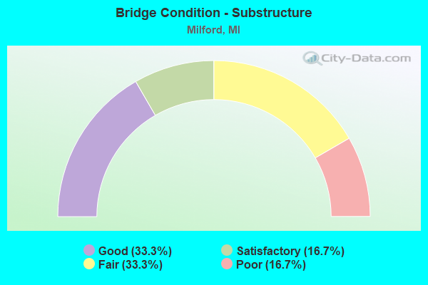
- Bridge Condition - Substructure
- 33.3%Good
- 16.7%Satisfactory
- 33.3%Fair
- 16.7%Poor
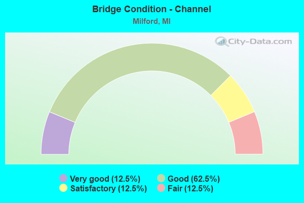
- Bridge Condition - Channel
- 12.5%Very good
- 62.5%Good
- 12.5%Satisfactory
- 12.5%Fair
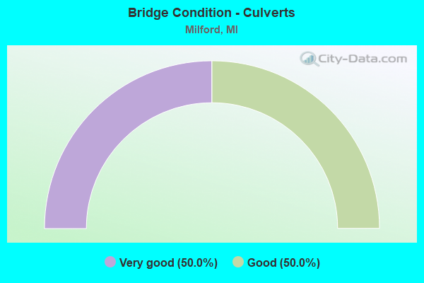
- Bridge Condition - Culverts
- 50.0%Very good
- 50.0%Good
Find on map >> Show street view
Structure Number: 8178, Location: BET MARTINDALE AND GARNER (Lat: 42.579275, Lng: -83.626633), Route carried "on" structure: County highway 2059, Year Built: 1985, Status: Open, Structure Length: 1.95m (6.40ft), Average Daily Traffic: 12,300 (year 2014), Truck Traffic: 3%, Average Future Daily Traffic: 16,548 (year 2031), Design Load: HS 20+Mod, Features Intersected: HURON RIVER, Facility Carried by Structure: GENERAL MOTORS RD
Minimum Vertical Clearance: 30.48m (100.00ft), Kilometerpoint: 2.664, Lanes on structure: 2, Owner: County Highway Agency, Approaching Roadway Width: 8.5m (27.9ft), Skew: 4 degrees, Material/Design: Prestressed concrete, Design/Construction: Box Beam or Girders - Multiple, Number Of Spans In Main Unit: 1, Length of Maximum Span: 19.2m (63.0ft), Curb-To-Curb Width: 12.3m (40.4ft), Out-to-Out Width: 13.4m (44.0ft)
Condition: Deck: Satisfactory, Superstructure: Good, Substructure: Good, Channel: Good, Operating Rating: 73.4 metric tons, Method Used To Determine Operating Rating: Load Factor (LF), Inventory Rating: 43.9 metric tons, Method Used To Determine Inventory Rating: Load Factor (LF), Structural Evaluation: Better than present minimum criteria, Deck Geometry: Somewhat better than minimum adequacy, Waterway Adequacy: Equal to present minimum criteria, Approach Roadway Alignment: Equal to present desirable criteria, Designated Inspection Frequency: Every 24 months, Inspection Date: June 2020, Deck Structure Type: Concrete Cast-file-Place, Wearing Surface/Protective System: Wearing Surface: Monolithic Concrete, Deck Protection: Epoxy Coated Reinforcing
Find on map >> Show street view
Structure Number: 8203, Location: WEST OF MARTINDALE (Lat: 42.564733, Lng: -83.626650), Route carried "on" structure: County highway , Year Built: 1964, Status: Open, Structure Length: 1.22m (4.00ft), Average Daily Traffic: 750 (year 2014), Truck Traffic: 3%, Average Future Daily Traffic: 985 (year 2031), Design Load: HS 20+Mod, Features Intersected: HURON RIVER, Facility Carried by Structure: DAWSON
Minimum Vertical Clearance: 30.48m (100.00ft), Kilometerpoint: 0.954, Lanes on structure: 2, Owner: County Highway Agency, Approaching Roadway Width: 9.8m (32.2ft), Material/Design: Prestressed concrete, Design/Construction: Box Beam or Girders - Multiple, Number Of Spans In Main Unit: 1, Length of Maximum Span: 11.2m (36.7ft), Curb or Sidewalk Widths: Left: 0.8m (2.6ft), Right: 0.8m (2.6ft), Curb-To-Curb Width: 8.2m (26.9ft), Out-to-Out Width: 10.1m (33.1ft)
Condition: Deck: Good, Superstructure: Satisfactory, Substructure: Poor, Channel: Fair, Operating Rating: 76.1 metric tons, Method Used To Determine Operating Rating: Load Factor (LF), Inventory Rating: 45.6 metric tons, Method Used To Determine Inventory Rating: Load Factor (LF), Structural Evaluation: Meets minimum limits, Deck Geometry: Somewhat better than minimum adequacy, Waterway Adequacy: Equal to present desirable criteria, Approach Roadway Alignment: Equal to present desirable criteria, Length Of Structure Improvement: 2.44m (8.01ft), Designated Inspection Frequency: Every 12 months, Inspection Date: June 2021, Bridge Improvement Cost: $15,000, Roadway Improvement Cost: $2,000, Total Project Cost: $18,000, Deck Structure Type: Concrete Precast Panels, Wearing Surface/Protective System: Wearing Surface: Bituminous, Membrane: Preformed Fabric
Find on map >> Show street view
Structure Number: 8205, Location: NORTH OF GARDEN (Lat: 42.578469, Lng: -83.579961), Route carried "on" structure: County highway , Year Built: 1964, Status: Open, Structure Length: 0.91m (2.99ft), Average Daily Traffic: 680 (year 2014), Truck Traffic: 3%, Average Future Daily Traffic: 920 (year 2031), Design Load: HS 20+Mod, Features Intersected: HURON RIVER, Facility Carried by Structure: BURNS
Minimum Vertical Clearance: 30.48m (100.00ft), Kilometerpoint: 0.082, Lanes on structure: 2, Owner: County Highway Agency, Approaching Roadway Width: 8.2m (26.9ft), Material/Design: Prestressed concrete, Design/Construction: Box Beam or Girders - Multiple, Number Of Spans In Main Unit: 1, Length of Maximum Span: 8.2m (26.9ft), Curb or Sidewalk Widths: Left: 0.8m (2.6ft), Right: 0.8m (2.6ft), Curb-To-Curb Width: 6.4m (21.0ft), Out-to-Out Width: 8.2m (26.9ft)
Condition: Deck: Satisfactory, Superstructure: Satisfactory, Substructure: Fair, Channel: Satisfactory, Operating Rating: 81.6 metric tons, Method Used To Determine Operating Rating: Load Factor (LF) rating reported by rating factor (RF) method using MS18 loading, Inventory Rating: 48.9 metric tons, Method Used To Determine Inventory Rating: Load Factor (LF) rating reported by rating factor (RF) method using MS18 loading, Structural Evaluation: Somewhat better than minimum adequacy, Deck Geometry: High priority of corrective action, Waterway Adequacy: Equal to present desirable criteria, Approach Roadway Alignment: Equal to present desirable criteria, Length Of Structure Improvement: 2.44m (8.01ft), Designated Inspection Frequency: Every 24 months, Inspection Date: June 2020, Bridge Improvement Cost: $15,000, Roadway Improvement Cost: $2,000, Total Project Cost: $18,000, Deck Structure Type: Concrete Precast Panels, Wearing Surface/Protective System: Wearing Surface: Bituminous, Membrane: Preformed Fabric
Find on map >> Show street view
Structure Number: 8241, Location: IN MILFORD S OF CANAL ST (Lat: 42.587131, Lng: -83.600433), Route carried "on" structure: City street 2059, Year Built: 1989, Status: Open, Structure Length: 0.73m (2.40ft), Average Daily Traffic: 14,620 (year 2007), Truck Traffic: 10%, Average Future Daily Traffic: 16,082 (year 2033), Design Load: HS 20, Features Intersected: HURON RIVER, Facility Carried by Structure: MAIN ST
Minimum Vertical Clearance: 30.48m (100.00ft), Kilometerpoint: 1.186, Lanes on structure: 2, Owner: City or Municipal Highway Agency, Approaching Roadway Width: 9.1m (29.9ft), Material/Design: Concrete, Design/Construction: Culvert, Number Of Spans In Main Unit: 1, Length of Maximum Span: 7.3m (24.0ft), Curb or Sidewalk Widths: Left: 1.5m (4.9ft), Right: 1.5m (4.9ft), Curb-To-Curb Width: 7.9m (25.9ft), Out-to-Out Width: 11.5m (37.7ft)
Condition: Channel: Good, Culverts: Good, Operating Rating: 54.5 metric tons, Method Used To Determine Operating Rating: Field evaluation and documented engineering judgment, Inventory Rating: 32.7 metric tons, Method Used To Determine Inventory Rating: Field evaluation and documented engineering judgment, Structural Evaluation: Better than present minimum criteria, Deck Geometry: High priority of replacement, Waterway Adequacy: Meets minimum limits, Approach Roadway Alignment: Equal to present desirable criteria, Designated Inspection Frequency: Every 24 months, Inspection Date: October 2021, Deck Structure Type: Concrete Precast Panels, Wearing Surface/Protective System: Wearing Surface: Bituminous
Find on map >> Show street view
Structure Number: 8242, Location: EAST OF MILFORD RD (Lat: 42.585578, Lng: -83.596739), Route carried "on" structure: City street , Year Built: 1977, Status: Open, Structure Length: 2.59m (8.50ft), Average Daily Traffic: 8,545 (year 2014), Truck Traffic: 5%, Average Future Daily Traffic: 9,000 (year 2034), Design Load: HS 20+Mod, Features Intersected: HURON RIVER, Facility Carried by Structure: HURON RD
Minimum Vertical Clearance: 30.48m (100.00ft), Kilometerpoint: 0.740, Lanes on structure: 2, Owner: City or Municipal Highway Agency, Approaching Roadway Width: 10.1m (33.1ft), Material/Design: Prestressed concrete, Design/Construction: Box Beam or Girders - Multiple, Number Of Spans In Main Unit: 3, Length of Maximum Span: 10.6m (34.8ft), Curb or Sidewalk Widths: Left: 1.3m (4.3ft), Right: 1.3m (4.3ft), Curb-To-Curb Width: 9.7m (31.8ft), Out-to-Out Width: 13.2m (43.3ft)
Condition: Deck: Satisfactory, Superstructure: Fair, Substructure: Satisfactory, Channel: Good, Operating Rating: 60.3 metric tons, Method Used To Determine Operating Rating: Load Factor (LF) rating reported by rating factor (RF) method using MS18 loading, Inventory Rating: 36.0 metric tons, Method Used To Determine Inventory Rating: Load Factor (LF) rating reported by rating factor (RF) method using MS18 loading, Structural Evaluation: Somewhat better than minimum adequacy, Deck Geometry: High priority of corrective action, Waterway Adequacy: Better than present minimum criteria, Approach Roadway Alignment: Equal to present desirable criteria, Designated Inspection Frequency: Every 24 months, Inspection Date: October 2021, Deck Structure Type: Concrete Precast Panels, Wearing Surface/Protective System: Wearing Surface: Bituminous, Membrane: Preformed Fabric
Find on map >> Show street view
Structure Number: 8243, Location: SOUTHEAST OF HURON BRIDGE (Lat: 42.582247, Lng: -83.590067), Route carried "on" structure: City street , Year Built: 1989, Status: Open, Structure Length: 1.15m (3.77ft), Average Daily Traffic: 400 (year 1990), Truck Traffic: 1%, Average Future Daily Traffic: 800 (year 2005), Design Load: HS 20, Features Intersected: HURON RIVER, Facility Carried by Structure: MONT EAGLE ROAD
Minimum Vertical Clearance: 30.48m (100.00ft), Kilometerpoint: 0.219, Lanes on structure: 2, Owner: City or Municipal Highway Agency, Approaching Roadway Width: 7.3m (24.0ft), Material/Design: Prestressed concrete, Design/Construction: Box Beam or Girders - Multiple, Number Of Spans In Main Unit: 1, Length of Maximum Span: 10.3m (33.8ft), Curb-To-Curb Width: 7.3m (24.0ft), Out-to-Out Width: 7.5m (24.6ft)
Condition: Deck: Good, Superstructure: Good, Substructure: Good, Channel: Good, Operating Rating: 59.0 metric tons, Method Used To Determine Operating Rating: Load Factor (LF) rating reported by rating factor (RF) method using MS18 loading, Inventory Rating: 35.3 metric tons, Method Used To Determine Inventory Rating: Load Factor (LF) rating reported by rating factor (RF) method using MS18 loading, Structural Evaluation: Better than present minimum criteria, Deck Geometry: Somewhat better than minimum adequacy, Waterway Adequacy: Equal to present desirable criteria, Approach Roadway Alignment: Somewhat better than minimum adequacy, Designated Inspection Frequency: Every 24 months, Inspection Date: October 2021, Deck Structure Type: Concrete Precast Panels, Wearing Surface/Protective System: Wearing Surface: Bituminous
Find on map >> Show street view
Structure Number: 8244, Location: W OF MILFORD RD (Lat: 42.585386, Lng: -83.608053), Route carried "on" structure: City street , Year Built: 2008, Status: Open, Structure Length: 1.35m (4.43ft), Average Daily Traffic: 1,500 (year 2006), Average Future Daily Traffic: 2,700 (year 2026), Design Load: HS 20+Mod, Features Intersected: HURON RIVER (MILL POND), Facility Carried by Structure: PETERS ST
Minimum Vertical Clearance: 30.48m (100.00ft), Kilometerpoint: 0.306, Lanes on structure: 2, Owner: City or Municipal Highway Agency, Approaching Roadway Width: 83.2m (273.0ft), Material/Design: Concrete, Design/Construction: Culvert, Number Of Spans In Main Unit: 1, Length of Maximum Span: 12.8m (42.0ft), Curb or Sidewalk Widths: Left: 1.1m (3.6ft), Right: 2.1m (6.9ft), Curb-To-Curb Width: 8.2m (26.9ft), Out-to-Out Width: 12.4m (40.7ft)
Condition: Channel: Very good, Culverts: Very good, Operating Rating: 54.6 metric tons, Method Used To Determine Operating Rating: Field evaluation and documented engineering judgment, Inventory Rating: 32.7 metric tons, Method Used To Determine Inventory Rating: Field evaluation and documented engineering judgment, Structural Evaluation: Equal to present desirable criteria, Deck Geometry: Meets minimum limits, Waterway Adequacy: Somewhat better than minimum adequacy, Approach Roadway Alignment: Somewhat better than minimum adequacy, Designated Inspection Frequency: Every 24 months, Inspection Date: October 2021
Find on map >> Show street view
Structure Number: 13423, Location: MILFORD TWP SEC 28 (Lat: 42.549167, Lng: -83.631278), Route carried "on" structure: County highway , Year Built: 1940, Status: Posted for load, Structure Length: 3.84m (12.60ft), Average Daily Traffic: 750 (year 2000), Average Future Daily Traffic: 860 (year 2020), Design Load: HS 20+Mod, Features Intersected: HURON RIVER, Facility Carried by Structure: BUNO ROAD
Minimum Vertical Clearance: 30.48m (100.00ft), Kilometerpoint: 4.426, Lanes on structure: 2, Owner: County Highway Agency, Approaching Roadway Width: 11.0m (36.1ft), Material/Design: Concrete, Design/Construction: Tee Beam, Number Of Spans In Main Unit: 3, Length of Maximum Span: 15.3m (50.2ft), Curb or Sidewalk Widths: Left: 1.8m (5.9ft), Right: 1.8m (5.9ft), Curb-To-Curb Width: 12.2m (40.0ft), Out-to-Out Width: 17.7m (58.1ft)
Condition: Deck: Fair, Superstructure: Fair, Substructure: Fair, Channel: Good, Operating Rating: 26.7 metric tons, Method Used To Determine Operating Rating: Load Factor (LF), Inventory Rating: 15.0 metric tons, Method Used To Determine Inventory Rating: Load Factor (LF), Structural Evaluation: Meets minimum limits, Deck Geometry: Equal to present desirable criteria, Waterway Adequacy: Better than present minimum criteria, Approach Roadway Alignment: Equal to present minimum criteria, Bridge Posting: Required (Relationship of Operating Rating to Maximum Legal Load: > 39.9% below), Designated Inspection Frequency: Every 12 months, Inspection Date: June 2021, Deck Structure Type: Concrete Cast-file-Place, Wearing Surface/Protective System: Wearing Surface: Integral Concrete
Find on map >> Show street view
Structure Number: 7824, Location: 3.3 MI E OF LIVINGSTON CO (Lat: 42.641667, Lng: -83.615892), Route carried "under" structure: State highway 59, Year Built: 1936, Structure Length: 0. m, Average Daily Traffic: 31,140 (year 2007), Truck Traffic: 4%, Features Intersected: M-59, Facility Carried by Structure: CSX RR
Minimum Vertical Clearance: 4.65m (15.26ft), Kilometerpoint: 5.272, Lanes under structure: 2, Material/Design: Steel, Design/Construction: Girder and Floorbeam System, Length of Maximum Span: 15.5m (50.9ft)
Find on map >> Show street view
Structure Number: 7825, Location: 3.3 MI E LIVINGSTON CO LN (Lat: 42.641961, Lng: -83.615908), Route carried "under" structure: State highway 59, Year Built: 1980, Structure Length: 0. m, Average Daily Traffic: 15,570 (year 2007), Truck Traffic: 4%, Features Intersected: M-59 WB, Facility Carried by Structure: CSX RR
Minimum Vertical Clearance: 4.67m (15.32ft), Kilometerpoint: 5.271, Lanes under structure: 2, Material/Design: Steel, Design/Construction: Stringer/Multi-beam, Length of Maximum Span: 20.1m (65.9ft)