Bridge Statistics for Minerva, New York (NY)
Condition, Traffic, Stress, Structural Evaluation, Project Costs
- National Bridge Inventory (NBI) Statistics
- 13Number of bridges
- 72ft / 21.8mTotal length
- $9,492,000Total costs
- 5,035Total average daily traffic
- 426Total average daily truck traffic
- 5,409Total future (year 2037) average daily traffic
- National Bridge Inventory (NBI) Registered Bridges for Minerva
- No street view available for this location
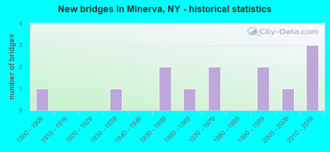
- New bridges - historical statistics
- 11900-1909
- 11930-1939
- 21950-1959
- 11960-1969
- 21970-1979
- 21990-1999
- 12000-2009
- 32010-2019
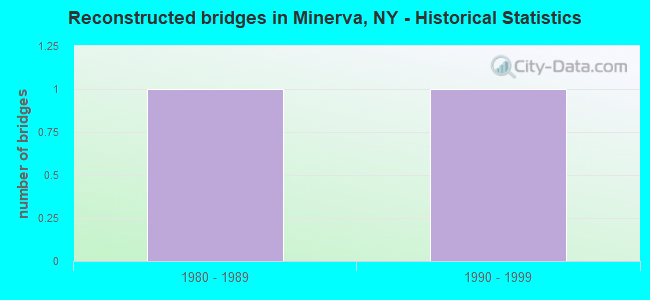
- Reconstructed bridges - Historical Statistics
- 11980-1989
- 11990-1999
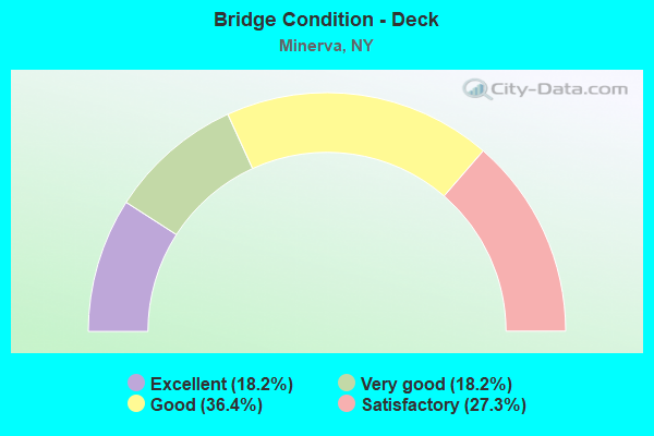
- Bridge Condition - Deck
- 18.2%Excellent
- 18.2%Very good
- 36.4%Good
- 27.3%Satisfactory
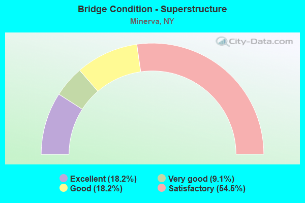
- Bridge Condition - Superstructure
- 18.2%Excellent
- 9.1%Very good
- 18.2%Good
- 54.5%Satisfactory
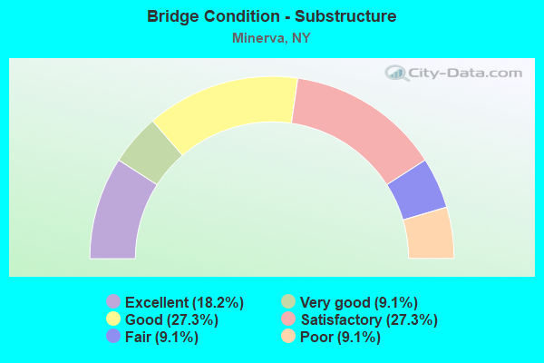
- Bridge Condition - Substructure
- 18.2%Excellent
- 9.1%Very good
- 27.3%Good
- 27.3%Satisfactory
- 9.1%Fair
- 9.1%Poor
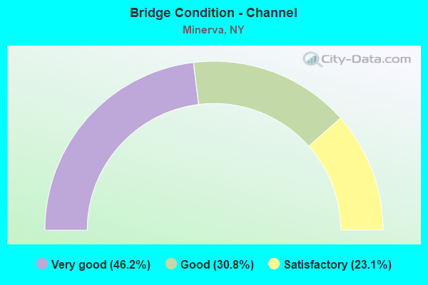
- Bridge Condition - Channel
- 46.2%Very good
- 30.8%Good
- 23.1%Satisfactory
Find on map >> Show street view
Structure Number: 10205, Location: RT 28N & BOREAS RIVER JCT (Lat: 43.891811, Lng: -74.015117), Route carried "on" structure: State highway 28N, Year Built: 1977, Status: Open, Structure Length: 3.87m (12.70ft), Average Daily Traffic: 1,041 (year 2018), Truck Traffic: 10%, Average Future Daily Traffic: 1,085 (year 2040), Design Load: HS 20, Features Intersected: BOREAS RIVER
Minimum Vertical Clearance: 30+ m (98+ ft), Kilometerpoint: 24.360, Lanes on structure: 2, Base Highway Network: Yes, Owner: State Highway Agency, Approaching Roadway Width: 10.4m (34.1ft), Skew: 3 degrees, Material/Design: Steel, Design/Construction: Stringer/Multi-beam, Number Of Spans In Main Unit: 1, Length of Maximum Span: 36.2m (118.8ft), Curb-To-Curb Width: 10.4m (34.1ft), Out-to-Out Width: 11.0m (36.1ft)
Condition: Deck: Satisfactory, Superstructure: Satisfactory, Substructure: Poor, Channel: Good, Inventory Rating: 67.1 metric tons, Method Used To Determine Inventory Rating: Load Factor (LF), Structural Evaluation: Meets minimum limits, Deck Geometry: Equal to present minimum criteria, Waterway Adequacy: Superior to present desirable criteria, Approach Roadway Alignment: Better than present minimum criteria, Length Of Structure Improvement: 3.87m (12.70ft), Designated Inspection Frequency: Every 24 months, Inspection Date: July 2020, Bridge Improvement Cost: $1,334,000, Roadway Improvement Cost: $781,000, Total Project Cost: $2,116,000 ( Estimate for 2021), Deck Structure Type: Concrete Cast-file-Place, Wearing Surface/Protective System: Wearing Surface: Integral Concrete
Find on map >> Show street view
Structure Number: 102051, Location: 28N 1.3 MI N WARREN CO L (Lat: 43.768144, Lng: -73.957183), Route carried "on" structure: State highway 28N, Year Built: 1938, Status: Open, Structure Length: 0.73m (2.40ft), Average Daily Traffic: 693 (year 2018), Truck Traffic: 11%, Average Future Daily Traffic: 722 (year 2040), Features Intersected: KELSO BK
Minimum Vertical Clearance: 30+ m (98+ ft), Kilometerpoint: 41.094, Lanes on structure: 2, Base Highway Network: Yes, Owner: State Highway Agency, Approaching Roadway Width: 7.9m (25.9ft), Skew: 4 degrees, Material/Design: Concrete, Design/Construction: Culvert, Number Of Spans In Main Unit: 1, Length of Maximum Span: 6.7m (22.0ft)
Condition: Channel: Good, Culverts: Satisfactory, Operating Rating: 74.0 metric tons, Method Used To Determine Operating Rating: Field evaluation and documented engineering judgment, Inventory Rating: 29.4 metric tons, Method Used To Determine Inventory Rating: Field evaluation and documented engineering judgment, Structural Evaluation: Equal to present minimum criteria, Waterway Adequacy: Equal to present minimum criteria, Approach Roadway Alignment: Equal to present desirable criteria, Length Of Structure Improvement: 0.73m (2.40ft), Designated Inspection Frequency: Every 24 months, Inspection Date: July 2020, Bridge Improvement Cost: $102,000, Roadway Improvement Cost: $60,000, Total Project Cost: $162,000 ( Estimate for 2021), Wearing Surface/Protective System: Wearing Surface: Bituminous
Find on map >> Show street view
Structure Number: 109587, Location: 8 MI E OF NEWCOMB ON 28N (Lat: 43.918403, Lng: -74.022119), Route carried "on" structure: State highway 28N, Year Built: 1956, Year Reconstructed: 2002, Status: Open, Structure Length: 0.85m (2.79ft), Average Daily Traffic: 1,041 (year 2018), Truck Traffic: 10%, Average Future Daily Traffic: 1,085 (year 2040), Features Intersected: STILLWATER BROOK
Minimum Vertical Clearance: 30+ m (98+ ft), Kilometerpoint: 21.303, Lanes on structure: 2, Base Highway Network: Yes, Owner: State Highway Agency, Approaching Roadway Width: 10.4m (34.1ft), Material/Design: Steel, Design/Construction: Culvert, Number Of Spans In Main Unit: 3, Length of Maximum Span: 2.1m (6.9ft)
Condition: Channel: Satisfactory, Culverts: Satisfactory, Operating Rating: 74.0 metric tons, Method Used To Determine Operating Rating: Field evaluation and documented engineering judgment, Inventory Rating: 32.7 metric tons, Method Used To Determine Inventory Rating: Field evaluation and documented engineering judgment, Structural Evaluation: Equal to present minimum criteria, Waterway Adequacy: Equal to present minimum criteria, Approach Roadway Alignment: Better than present minimum criteria, Length Of Structure Improvement: 0.85m (2.79ft), Designated Inspection Frequency: Every 24 months, Inspection Date: July 2020, Bridge Improvement Cost: $156,000, Roadway Improvement Cost: $91,000, Total Project Cost: $247,000 ( Estimate for 2021), Wearing Surface/Protective System: Wearing Surface: Bituminous
Find on map >> Show street view
Structure Number: 330197, Location: 4.5 MI SW OF SCHROON LAKE (Lat: 43.773661, Lng: -73.919203), Route carried "on" structure: County highway , Year Built: 2018, Status: Open, Structure Length: 1.86m (6.10ft), Average Daily Traffic: 66 (year 2019), Truck Traffic: 7%, Average Future Daily Traffic: 92 (year 2039), Features Intersected: MINERVA STREAM, Facility Carried by Structure: TROUT BROOK ROAD
Minimum Vertical Clearance: 30+ m (98+ ft), Kilometerpoint: 0.338, Lanes on structure: 2, Owner: County Highway Agency, Approaching Roadway Width: 7.3m (24.0ft), Skew: 2 degrees, Material/Design: Prestressed concrete, Design/Construction: Tee Beam, Number Of Spans In Main Unit: 1, Length of Maximum Span: 18.3m (60.0ft), Curb-To-Curb Width: 7.3m (24.0ft), Out-to-Out Width: 8.3m (27.2ft)
Condition: Deck: Excellent, Superstructure: Excellent, Substructure: Excellent, Channel: Very good, Operating Rating: 85.6 metric tons, Method Used To Determine Operating Rating: Field evaluation and documented engineering judgment, Inventory Rating: 40.8 metric tons, Method Used To Determine Inventory Rating: Field evaluation and documented engineering judgment, Structural Evaluation: Superior to present desirable criteria, Deck Geometry: Equal to present minimum criteria, Waterway Adequacy: Equal to present minimum criteria, Approach Roadway Alignment: Equal to present minimum criteria, Length Of Structure Improvement: 1.85m (6.07ft), Designated Inspection Frequency: Every 24 months, Inspection Date: June 2020, Bridge Improvement Cost: $714,000, Roadway Improvement Cost: $418,000, Total Project Cost: $1,132,000 ( Estimate for 2021), Deck Structure Type: Concrete Cast-file-Place, Wearing Surface/Protective System: Wearing Surface: Monolithic Concrete, Deck Protection: Epoxy Coated Reinforcing
Find on map >> Show street view
Structure Number: 330198, Location: 3MI EAST OLMSTEDVILLE (Lat: 43.776794, Lng: -73.899703), Route carried "on" structure: Other road , Year Built: 2012, Status: Open, Structure Length: 1.77m (5.81ft), Average Daily Traffic: 16 (year 2018), Average Future Daily Traffic: 22 (year 2038), Features Intersected: TROUT BROOK, Facility Carried by Structure: GOUCHIE ROAD
Minimum Vertical Clearance: 30+ m (98+ ft), Kilometerpoint: 0.306, Lanes on structure: 2, Owner: County Highway Agency, Approaching Roadway Width: 4.9m (16.1ft), Material/Design: Steel, Design/Construction: Stringer/Multi-beam, Number Of Spans In Main Unit: 1, Length of Maximum Span: 17.1m (56.1ft), Curb-To-Curb Width: 5.0m (16.4ft), Out-to-Out Width: 5.8m (19.0ft)
Condition: Deck: Very good, Superstructure: Satisfactory, Substructure: Very good, Channel: Very good, Operating Rating: 84.7 metric tons, Method Used To Determine Operating Rating: Field evaluation and documented engineering judgment, Inventory Rating: 40.8 metric tons, Method Used To Determine Inventory Rating: Field evaluation and documented engineering judgment, Structural Evaluation: Equal to present minimum criteria, Deck Geometry: High priority of corrective action, Waterway Adequacy: Superior to present desirable criteria, Approach Roadway Alignment: Somewhat better than minimum adequacy, Length Of Structure Improvement: 1.76m (5.77ft), Designated Inspection Frequency: Every 24 months, Inspection Date: May 2021, Bridge Improvement Cost: $208,000, Roadway Improvement Cost: $122,000, Total Project Cost: $329,000 ( Estimate for 2021), Deck Structure Type: Concrete Cast-file-Place, Wearing Surface/Protective System: Wearing Surface: Integral Concrete, Deck Protection: Epoxy Coated Reinforcing
Find on map >> Show street view
Structure Number: 330199, Location: .5 MI W OF OLMSTEDVILLE (Lat: 43.775469, Lng: -73.945261), Route carried "on" structure: County highway , Year Built: 1999, Status: Open, Structure Length: 1.07m (3.51ft), Average Daily Traffic: 538 (year 2017), Truck Traffic: 6%, Average Future Daily Traffic: 561 (year 2040), Design Load: HS 25 or greater, Features Intersected: MINERVA STREAM, Facility Carried by Structure: CR 30, OLMSTEDVILL
Minimum Vertical Clearance: 30+ m (98+ ft), Kilometerpoint: 3.057, Lanes on structure: 2, Owner: County Highway Agency, Approaching Roadway Width: 7.6m (24.9ft), Material/Design: Concrete, Design/Construction: Frame, Number Of Spans In Main Unit: 1, Length of Maximum Span: 10.3m (33.8ft), Curb-To-Curb Width: 7.6m (24.9ft), Out-to-Out Width: 8.2m (26.9ft)
Condition: Deck: Good, Superstructure: Good, Substructure: Good, Channel: Good, Operating Rating: 79.9 metric tons, Method Used To Determine Operating Rating: Field evaluation and documented engineering judgment, Inventory Rating: 40.8 metric tons, Method Used To Determine Inventory Rating: Field evaluation and documented engineering judgment, Structural Evaluation: Better than present minimum criteria, Deck Geometry: Meets minimum limits, Waterway Adequacy: Superior to present desirable criteria, Approach Roadway Alignment: Equal to present minimum criteria, Length Of Structure Improvement: 1.06m (3.48ft), Designated Inspection Frequency: Every 24 months, Inspection Date: July 2021, Bridge Improvement Cost: $261,000, Roadway Improvement Cost: $153,000, Total Project Cost: $414,000 ( Estimate for 2021)
Find on map >> Show street view
Structure Number: 3302, Location: 2 MI NE OF MINERVA (Lat: 43.799622, Lng: -73.947981), Route carried "on" structure: County highway , Year Built: 1977, Status: Open, Structure Length: 1.89m (6.20ft), Average Daily Traffic: 143 (year 2018), Truck Traffic: 6%, Average Future Daily Traffic: 200 (year 2038), Design Load: H 20, Features Intersected: MINERVA STREAM, Facility Carried by Structure: COUNTY ROAD 37
Minimum Vertical Clearance: 30+ m (98+ ft), Kilometerpoint: 5.245, Lanes on structure: 2, Owner: County Highway Agency, Approaching Roadway Width: 7.9m (25.9ft), Material/Design: Steel, Design/Construction: Stringer/Multi-beam, Number Of Spans In Main Unit: 1, Length of Maximum Span: 18.5m (60.7ft), Curb-To-Curb Width: 8.0m (26.2ft), Out-to-Out Width: 8.5m (27.9ft)
Condition: Deck: Satisfactory, Superstructure: Satisfactory, Substructure: Satisfactory, Channel: Very good, Operating Rating: 33.4 metric tons, Method Used To Determine Operating Rating: Load and Resistance Factor Rating (LRFR) rating reported by rating factor(RF) method using HL-93 loadings, Inventory Rating: 25.6 metric tons, Method Used To Determine Inventory Rating: Load and Resistance Factor Rating (LRFR) rating reported by rating factor(RF) method using HL-93 loadings, Structural Evaluation: Equal to present minimum criteria, Deck Geometry: Somewhat better than minimum adequacy, Waterway Adequacy: Equal to present minimum criteria, Approach Roadway Alignment: Meets minimum limits, Length Of Structure Improvement: 1.88m (6.17ft), Designated Inspection Frequency: Every 24 months, Inspection Date: July 2020, Bridge Improvement Cost: $804,000, Roadway Improvement Cost: $471,000, Total Project Cost: $1,276,000 ( Estimate for 2021), Deck Structure Type: Wood or Timber, Wearing Surface/Protective System: Wearing Surface: Bituminous
Find on map >> Show street view
Structure Number: 330201, Location: 2 MILES NE OF MINERVA (Lat: 43.819056, Lng: -73.938119), Route carried "on" structure: Other road , Year Built: 1900, Year Reconstructed: 1986, Status: Posted for load-capacity, Structure Length: 1.22m (4.00ft), Average Daily Traffic: 3 (year 2018), Truck Traffic: 6%, Average Future Daily Traffic: 4 (year 2038), Features Intersected: MINERVA STREAM, Facility Carried by Structure: SHEVLIN ROAD
Minimum Vertical Clearance: 30+ m (98+ ft), Kilometerpoint: 0.129, Lanes on structure: 1, Owner: County Highway Agency, Approaching Roadway Width: 4.3m (14.1ft), Material/Design: Steel, Design/Construction: Stringer/Multi-beam, Number Of Spans In Main Unit: 1, Length of Maximum Span: 11.5m (37.7ft), Curb-To-Curb Width: 4.4m (14.4ft), Out-to-Out Width: 4.9m (16.1ft)
Condition: Deck: Good, Superstructure: Good, Substructure: Satisfactory, Channel: Satisfactory, Operating Rating: 37.2 metric tons, Method Used To Determine Operating Rating: Load Factor (LF), Inventory Rating: 21.8 metric tons, Method Used To Determine Inventory Rating: Load Factor (LF), Structural Evaluation: Equal to present minimum criteria, Deck Geometry: Equal to present minimum criteria, Waterway Adequacy: Superior to present desirable criteria, Approach Roadway Alignment: Meets minimum limits, Length Of Structure Improvement: 1.21m (3.97ft), Designated Inspection Frequency: Every 24 months, Inspection Date: May 2020, Bridge Improvement Cost: $206,000, Roadway Improvement Cost: $120,000, Total Project Cost: $326,000 ( Estimate for 2021), Deck Structure Type: Wood or Timber, Wearing Surface/Protective System: Wearing Surface: Wood or Timber
Find on map >> Show street view
Structure Number: 330202, Location: 5 MILES NW OF MINERVA (Lat: 43.816839, Lng: -74.060858), Route carried "on" structure: Other road , Year Built: 2006, Status: Open, Structure Length: 2.01m (6.59ft), Average Daily Traffic: 81 (year 2017), Truck Traffic: 6%, Average Future Daily Traffic: 113 (year 2037), Features Intersected: BOREAS RIVER, Facility Carried by Structure: NORTHWOOD CLUB RD
Minimum Vertical Clearance: 30+ m (98+ ft), Kilometerpoint: 6.018, Lanes on structure: 1, Owner: County Highway Agency, Approaching Roadway Width: 3.7m (12.1ft), Material/Design: Steel, Design/Construction: Stringer/Multi-beam, Number Of Spans In Main Unit: 1, Length of Maximum Span: 19.5m (64.0ft), Curb-To-Curb Width: 4.0m (13.1ft), Out-to-Out Width: 4.8m (15.7ft)
Condition: Deck: Very good, Superstructure: Very good, Substructure: Good, Channel: Very good, Operating Rating: 48.6 metric tons, Method Used To Determine Operating Rating: Load and Resistance Factor Rating (LRFR) rating reported by rating factor(RF) method using HL-93 loadings, Inventory Rating: 37.6 metric tons, Method Used To Determine Inventory Rating: Load and Resistance Factor Rating (LRFR) rating reported by rating factor(RF) method using HL-93 loadings, Structural Evaluation: Better than present minimum criteria, Deck Geometry: Somewhat better than minimum adequacy, Waterway Adequacy: Equal to present minimum criteria, Approach Roadway Alignment: Equal to present minimum criteria, Length Of Structure Improvement: 2.01m (6.59ft), Designated Inspection Frequency: Every 24 months, Critical Feature Inspection Frequency: Every 24 months, Inspection Date: June 2020, Critical Feature Inspection Date: June 2020, Bridge Improvement Cost: $295,000, Roadway Improvement Cost: $173,000, Total Project Cost: $468,000 ( Estimate for 2021), Deck Structure Type: Concrete Precast Panels, Wearing Surface/Protective System: Wearing Surface: Bituminous, Membrane: Other
Find on map >> Show street view
Structure Number: 330266, Location: 2 MI NW CHENEY POND (Lat: 43.942689, Lng: -73.954933), Route carried "on" structure: County highway , Year Built: 1965, Status: Open, Structure Length: 2.53m (8.30ft), Average Daily Traffic: 191 (year 2018), Truck Traffic: 19%, Average Future Daily Traffic: 199 (year 2040), Features Intersected: BOREAS BROOK, Facility Carried by Structure: BOREAS ROAD
Minimum Vertical Clearance: 30+ m (98+ ft), Kilometerpoint: 11.472, Lanes on structure: 2, Owner: County Highway Agency, Approaching Roadway Width: 7.3m (24.0ft), Skew: 2 degrees, Material/Design: Steel, Design/Construction: Stringer/Multi-beam, Number Of Spans In Main Unit: 1, Length of Maximum Span: 23.4m (76.8ft), Curb-To-Curb Width: 7.3m (24.0ft), Out-to-Out Width: 8.8m (28.9ft)
Condition: Deck: Satisfactory, Superstructure: Satisfactory, Substructure: Satisfactory, Channel: Very good, Operating Rating: 58.6 metric tons, Method Used To Determine Operating Rating: Load and Resistance Factor Rating (LRFR) rating reported by rating factor(RF) method using HL-93 loadings, Inventory Rating: 45.4 metric tons, Method Used To Determine Inventory Rating: Load and Resistance Factor Rating (LRFR) rating reported by rating factor(RF) method using HL-93 loadings, Structural Evaluation: Equal to present minimum criteria, Deck Geometry: Somewhat better than minimum adequacy, Waterway Adequacy: Somewhat better than minimum adequacy, Approach Roadway Alignment: Equal to present desirable criteria, Length Of Structure Improvement: 2.52m (8.27ft), Designated Inspection Frequency: Every 24 months, Inspection Date: July 2020, Bridge Improvement Cost: $628,000, Roadway Improvement Cost: $368,000, Total Project Cost: $996,000 ( Estimate for 2021), Deck Structure Type: Concrete Cast-file-Place, Wearing Surface/Protective System: Wearing Surface: Bituminous
Find on map >> Show street view
Structure Number: 330272, Location: 8 MI SW OF SCHROON LAKE (Lat: 43.782342, Lng: -73.894403), Route carried "on" structure: County highway , Year Built: 2019, Status: Posted for load-capacity, Structure Length: 1.62m (5.31ft), Average Daily Traffic: 66 (year 2019), Truck Traffic: 7%, Average Future Daily Traffic: 92 (year 2039), Features Intersected: TROUT BROOK, Facility Carried by Structure: TROUT BROOK ROAD
Minimum Vertical Clearance: 30+ m (98+ ft), Kilometerpoint: 2.816, Lanes on structure: 2, Owner: County Highway Agency, Approaching Roadway Width: 6.0m (19.7ft), Skew: 2 degrees, Material/Design: Concrete, Design/Construction: Tee Beam, Number Of Spans In Main Unit: 1, Length of Maximum Span: 15.5m (50.9ft), Curb-To-Curb Width: 7.5m (24.6ft), Out-to-Out Width: 8.5m (27.9ft)
Condition: Deck: Excellent, Superstructure: Excellent, Substructure: Excellent, Channel: Very good, Operating Rating: 83.6 metric tons, Method Used To Determine Operating Rating: Field evaluation and documented engineering judgment, Inventory Rating: 40.8 metric tons, Method Used To Determine Inventory Rating: Field evaluation and documented engineering judgment, Structural Evaluation: Superior to present desirable criteria, Deck Geometry: Equal to present minimum criteria, Waterway Adequacy: Better than present minimum criteria, Approach Roadway Alignment: Equal to present minimum criteria, Length Of Structure Improvement: 1.61m (5.28ft), Designated Inspection Frequency: Every 24 months, Inspection Date: September 2021, Bridge Improvement Cost: $742,000, Roadway Improvement Cost: $434,000, Total Project Cost: $1,176,000 ( Estimate for 2021), Deck Structure Type: Concrete Cast-file-Place, Wearing Surface/Protective System: Wearing Surface: Integral Concrete, Deck Protection: Epoxy Coated Reinforcing
Find on map >> Show street view
Structure Number: 330273, Location: .5 MI N OF OLMSTEDVILLE (Lat: 43.773139, Lng: -73.931975), Route carried "on" structure: County highway , Year Built: 1999, Status: Open, Structure Length: 1.01m (3.31ft), Average Daily Traffic: 1,076 (year 2016), Truck Traffic: 5%, Average Future Daily Traffic: 1,122 (year 2040), Design Load: HS 25 or greater, Features Intersected: MINERVA STREAM, Facility Carried by Structure: CR 30, OLMSTEDVILL
Minimum Vertical Clearance: 30+ m (98+ ft), Kilometerpoint: 1.850, Lanes on structure: 2, Owner: County Highway Agency, Approaching Roadway Width: 8.2m (26.9ft), Material/Design: Concrete, Design/Construction: Frame, Number Of Spans In Main Unit: 1, Length of Maximum Span: 9.4m (30.8ft), Curb-To-Curb Width: 8.0m (26.2ft), Out-to-Out Width: 8.9m (29.2ft)
Condition: Deck: Good, Superstructure: Satisfactory, Substructure: Good, Channel: Good, Structural Evaluation: Equal to present minimum criteria, Deck Geometry: Meets minimum limits, Waterway Adequacy: Superior to present desirable criteria, Approach Roadway Alignment: Equal to present minimum criteria, Length Of Structure Improvement: 1.00m (3.28ft), Designated Inspection Frequency: Every 24 months, Inspection Date: May 2021, Bridge Improvement Cost: $215,000, Roadway Improvement Cost: $126,000, Total Project Cost: $341,000 ( Estimate for 2021)
Find on map >> Show street view
Structure Number: 330274, Location: .5MI E OLMSTEADVILLE (Lat: 43.773719, Lng: -73.927956), Route carried "on" structure: Other road , Year Built: 1953, Status: Open, Structure Length: 1.40m (4.59ft), Average Daily Traffic: 80 (year 2019), Truck Traffic: 2%, Average Future Daily Traffic: 112 (year 2039), Features Intersected: MINERVA STREAM, Facility Carried by Structure: DONNELLY ROAD
Minimum Vertical Clearance: 30+ m (98+ ft), Kilometerpoint: 0.563, Lanes on structure: 2, Owner: County Highway Agency, Approaching Roadway Width: 6.4m (21.0ft), Material/Design: Steel, Design/Construction: Stringer/Multi-beam, Number Of Spans In Main Unit: 1, Length of Maximum Span: 12.8m (42.0ft), Curb-To-Curb Width: 6.2m (20.3ft), Out-to-Out Width: 7.1m (23.3ft)
Condition: Deck: Good, Superstructure: Satisfactory, Substructure: Fair, Channel: Satisfactory, Operating Rating: 68.9 metric tons, Method Used To Determine Operating Rating: Load Factor (LF), Inventory Rating: 40.8 metric tons, Method Used To Determine Inventory Rating: Load Factor (LF), Structural Evaluation: Somewhat better than minimum adequacy, Deck Geometry: Somewhat better than minimum adequacy, Waterway Adequacy: Superior to present desirable criteria, Approach Roadway Alignment: Equal to present desirable criteria, Length Of Structure Improvement: 1.40m (4.59ft), Designated Inspection Frequency: Every 24 months, Inspection Date: August 2020, Bridge Improvement Cost: $321,000, Roadway Improvement Cost: $188,000, Total Project Cost: $509,000 ( Estimate for 2021), Deck Structure Type: Concrete Cast-file-Place, Wearing Surface/Protective System: Wearing Surface: Bituminous