Bridge Statistics for Minoa, New York (NY)
Condition, Traffic, Stress, Structural Evaluation, Project Costs
- National Bridge Inventory (NBI) Statistics
- 27Number of bridges
- 312ft / 95.0mTotal length
- $49,397,000Total costs
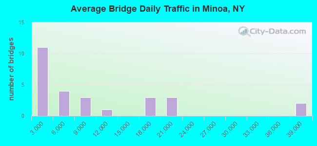
- 250,876Total average daily traffic
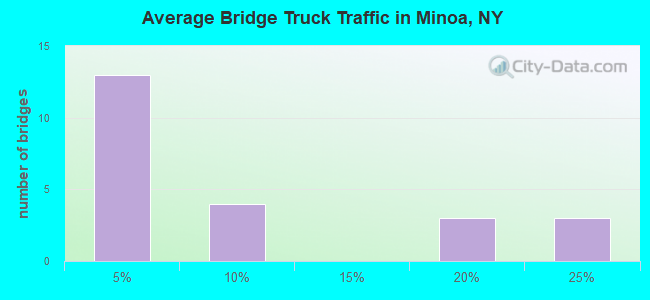
- 23,482Total average daily truck traffic
- National Bridge Inventory (NBI) Registered Bridges for Minoa
- No street view available for this location
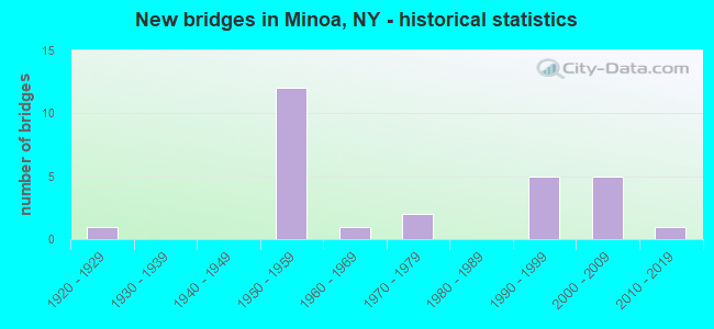
- New bridges - historical statistics
- 11920-1929
- 121950-1959
- 11960-1969
- 21970-1979
- 51990-1999
- 52000-2009
- 12010-2019
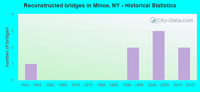
- Reconstructed bridges - Historical Statistics
- 11950-1959
- 01960-1969
- 01970-1979
- 01980-1989
- 21990-1999
- 32000-2009
- 22010-2019
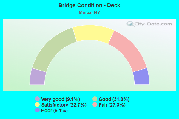
- Bridge Condition - Deck
- 9.1%Very good
- 31.8%Good
- 22.7%Satisfactory
- 27.3%Fair
- 9.1%Poor

- Bridge Condition - Superstructure
- 4.5%Excellent
- 22.7%Very good
- 27.3%Good
- 45.5%Satisfactory
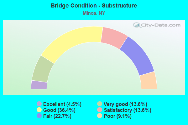
- Bridge Condition - Substructure
- 4.5%Excellent
- 13.6%Very good
- 36.4%Good
- 13.6%Satisfactory
- 22.7%Fair
- 9.1%Poor
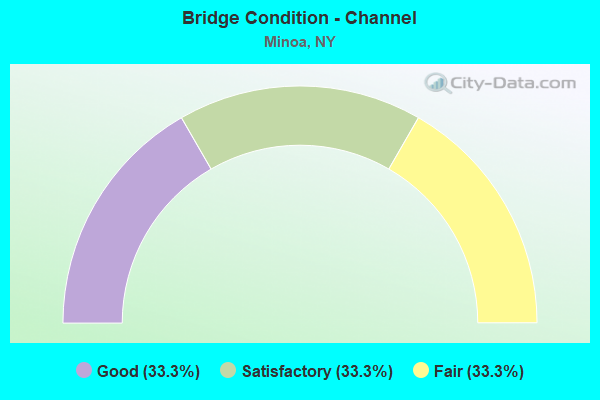
- Bridge Condition - Channel
- 33.3%Good
- 33.3%Satisfactory
- 33.3%Fair
Find on map >> Show street view
Structure Number: 104493, Location: 0.5 MI NW JCT RTS 290&257 (Lat: 43.057669, Lng: -76.007419), Route carried "on" structure: State highway 290, Year Built: 2000, Status: Open, Structure Length: 2.26m (7.41ft), Average Daily Traffic: 8,265 (year 2016), Truck Traffic: 3%, Average Future Daily Traffic: 10,040 (year 2040), Design Load: HS 25 or greater, Features Intersected: LIMESTONE CREEK
Minimum Vertical Clearance: 30+ m (98+ ft), Kilometerpoint: 12.550, Lanes on structure: 2, Base Highway Network: Yes, Owner: State Highway Agency, Approaching Roadway Width: 10.1m (33.1ft), Material/Design: Prestressed concrete, Design/Construction: Box Beam or Girders - Multiple, Number Of Spans In Main Unit: 1, Length of Maximum Span: 21.6m (70.9ft), Curb-To-Curb Width: 10.2m (33.5ft), Out-to-Out Width: 11.4m (37.4ft)
Condition: Deck: Good, Superstructure: Very good, Substructure: Very good, Channel: Fair, Operating Rating: 65.0 metric tons, Method Used To Determine Operating Rating: Load Factor (LF), Inventory Rating: 48.0 metric tons, Method Used To Determine Inventory Rating: Load Factor (LF), Structural Evaluation: Equal to present desirable criteria, Deck Geometry: Meets minimum limits, Waterway Adequacy: Meets minimum limits, Approach Roadway Alignment: Equal to present desirable criteria, Length Of Structure Improvement: 2.25m (7.38ft), Designated Inspection Frequency: Every 24 months, Inspection Date: April 2020, Bridge Improvement Cost: $813,000, Roadway Improvement Cost: $476,000, Total Project Cost: $1,288,000 ( Estimate for 2021), Wearing Surface/Protective System: Wearing Surface: Monolithic Concrete
Find on map >> Show street view
Structure Number: 220811, Location: NE OF VILLAGE OF MINOA (Lat: 43.082228, Lng: -75.991458), Route carried "on" structure: Other road , Year Built: 1991, Status: Open, Structure Length: 2.19m (7.19ft), Average Daily Traffic: 757 (year 2018), Truck Traffic: 4%, Average Future Daily Traffic: 1,060 (year 2038), Design Load: HS 20, Features Intersected: LIMESTONE CREEK, Facility Carried by Structure: EAST AVENUE
Minimum Vertical Clearance: 30+ m (98+ ft), Kilometerpoint: 0.129, Lanes on structure: 2, Owner: Town or Township Highway Agency, Approaching Roadway Width: 6.4m (21.0ft), Material/Design: Wood or Timber, Design/Construction: Stringer/Multi-beam, Number Of Spans In Main Unit: 2, Length of Maximum Span: 10.3m (33.8ft), Curb-To-Curb Width: 7.9m (25.9ft), Out-to-Out Width: 8.3m (27.2ft)
Condition: Deck: Good, Superstructure: Very good, Substructure: Good, Channel: Fair, Operating Rating: 49.9 metric tons, Method Used To Determine Operating Rating: Allowable Stress (AS), Inventory Rating: 35.4 metric tons, Method Used To Determine Inventory Rating: Allowable Stress (AS), Structural Evaluation: Better than present minimum criteria, Deck Geometry: Somewhat better than minimum adequacy, Waterway Adequacy: Meets minimum limits, Approach Roadway Alignment: Equal to present desirable criteria, Length Of Structure Improvement: 2.19m (7.19ft), Designated Inspection Frequency: Every 24 months, Underwater Inspection Frequency: Every 60 months, Inspection Date: March 2021, Underwater Inspection Date: November 2017, Bridge Improvement Cost: $483,000, Roadway Improvement Cost: $283,000, Total Project Cost: $765,000 ( Estimate for 2021), Deck Structure Type: Wood or Timber, Wearing Surface/Protective System: Wearing Surface: Bituminous, Membrane: Other
Find on map >> Show street view
Structure Number: 220813, Location: 4.8 MI NO. SH 5 - MANLIUS (Lat: 43.097589, Lng: -75.999308), Route carried "on" structure: Other road , Year Built: 1994, Status: Open, Structure Length: 3.41m (11.19ft), Average Daily Traffic: 361 (year 2017), Truck Traffic: 4%, Average Future Daily Traffic: 505 (year 2037), Design Load: HS 25 or greater, Features Intersected: LIMESTONE CREEK, Facility Carried by Structure: EAST MYERS ROAD
Minimum Vertical Clearance: 30+ m (98+ ft), Kilometerpoint: 1.850, Lanes on structure: 2, Owner: Town or Township Highway Agency, Approaching Roadway Width: 7.3m (24.0ft), Skew: 3 degrees, Material/Design: Prestressed concrete, Design/Construction: Box Beam or Girders - Multiple, Number Of Spans In Main Unit: 2, Length of Maximum Span: 15.8m (51.8ft), Curb-To-Curb Width: 7.9m (25.9ft), Out-to-Out Width: 8.5m (27.9ft)
Condition: Deck: Satisfactory, Superstructure: Good, Substructure: Good, Channel: Fair, Operating Rating: 80.7 metric tons, Method Used To Determine Operating Rating: Load Factor (LF), Inventory Rating: 36.3 metric tons, Method Used To Determine Inventory Rating: Load Factor (LF), Structural Evaluation: Better than present minimum criteria, Deck Geometry: Somewhat better than minimum adequacy, Waterway Adequacy: Meets minimum limits, Approach Roadway Alignment: Equal to present desirable criteria, Length Of Structure Improvement: 3.41m (11.19ft), Designated Inspection Frequency: Every 24 months, Inspection Date: September 2020, Bridge Improvement Cost: $810,000, Roadway Improvement Cost: $474,000, Total Project Cost: $1,284,000 ( Estimate for 2021), Deck Structure Type: Concrete Cast-file-Place, Wearing Surface/Protective System: Wearing Surface: Integral Concrete, Deck Protection: Epoxy Coated Reinforcing
Find on map >> Show street view
Structure Number: 320812, Location: 1.2 MI S OF SCHEPPS CRNS (Lat: 43.097250, Lng: -76.008556), Route carried "on" structure: County highway , Year Built: 1991, Status: Open, Structure Length: 2.19m (7.19ft), Average Daily Traffic: 416 (year 2017), Truck Traffic: 4%, Average Future Daily Traffic: 582 (year 2037), Design Load: HS 20, Features Intersected: BUTTERNUT CREEK, Facility Carried by Structure: WEST MYERS ROAD
Minimum Vertical Clearance: 30+ m (98+ ft), Kilometerpoint: 1.963, Lanes on structure: 2, Owner: County Highway Agency, Approaching Roadway Width: 8.5m (27.9ft), Skew: 3 degrees, Material/Design: Steel, Design/Construction: Stringer/Multi-beam, Number Of Spans In Main Unit: 1, Length of Maximum Span: 20.4m (66.9ft), Curb-To-Curb Width: 8.5m (27.9ft), Out-to-Out Width: 9.1m (29.9ft)
Condition: Deck: Good, Superstructure: Satisfactory, Substructure: Good, Channel: Satisfactory, Operating Rating: 98.0 metric tons, Method Used To Determine Operating Rating: Load Factor (LF), Inventory Rating: 58.1 metric tons, Method Used To Determine Inventory Rating: Load Factor (LF), Structural Evaluation: Equal to present minimum criteria, Deck Geometry: Somewhat better than minimum adequacy, Waterway Adequacy: Somewhat better than minimum adequacy, Approach Roadway Alignment: Equal to present desirable criteria, Length Of Structure Improvement: 2.19m (7.19ft), Designated Inspection Frequency: Every 24 months, Inspection Date: July 2021, Bridge Improvement Cost: $642,000, Roadway Improvement Cost: $376,000, Total Project Cost: $1,018,000 ( Estimate for 2021), Deck Structure Type: Concrete Cast-file-Place, Wearing Surface/Protective System: Wearing Surface: Integral Concrete, Deck Protection: Epoxy Coated Reinforcing
Find on map >> Show street view
Structure Number: 331271, Location: 3 MI N GREEN LAKES & SH 2 (Lat: 43.088275, Lng: -75.993819), Route carried "on" structure: County highway , Year Built: 1994, Status: Open, Structure Length: 3.90m (12.80ft), Average Daily Traffic: 4,266 (year 2019), Truck Traffic: 4%, Average Future Daily Traffic: 5,278 (year 2040), Design Load: HS 25 or greater, Features Intersected: LIMESTONE CREEK, Facility Carried by Structure: KIRKVILLE RD
Minimum Vertical Clearance: 30+ m (98+ ft), Kilometerpoint: 8.656, Lanes on structure: 2, Owner: County Highway Agency, Approaching Roadway Width: 10.4m (34.1ft), Skew: 3 degrees, Material/Design: Prestressed concrete, Design/Construction: Box Beam or Girders - Multiple, Number Of Spans In Main Unit: 2, Length of Maximum Span: 18.5m (60.7ft), Curb-To-Curb Width: 10.4m (34.1ft), Out-to-Out Width: 11.0m (36.1ft)
Condition: Deck: Poor, Superstructure: Good, Substructure: Good, Channel: Satisfactory, Operating Rating: 85.3 metric tons, Method Used To Determine Operating Rating: Load Factor (LF), Inventory Rating: 34.5 metric tons, Method Used To Determine Inventory Rating: Load Factor (LF), Structural Evaluation: Better than present minimum criteria, Deck Geometry: Somewhat better than minimum adequacy, Waterway Adequacy: Somewhat better than minimum adequacy, Approach Roadway Alignment: Equal to present desirable criteria, Length Of Structure Improvement: 3.90m (12.80ft), Designated Inspection Frequency: Every 24 months, Inspection Date: July 2020, Bridge Improvement Cost: $1,415,000, Roadway Improvement Cost: $829,000, Total Project Cost: $2,243,000 ( Estimate for 2021), Deck Structure Type: Concrete Cast-file-Place, Wearing Surface/Protective System: Wearing Surface: Integral Concrete, Deck Protection: Epoxy Coated Reinforcing
Find on map >> Show street view
Structure Number: 331273, Location: 1MI N KIRKVILLE CHTNGO R (Lat: 43.088831, Lng: -75.953867), Route carried "on" structure: County highway , Year Built: 1960, Status: Open, Structure Length: 1.83m (6.00ft), Average Daily Traffic: 1,474 (year 2017), Truck Traffic: 4%, Average Future Daily Traffic: 2,064 (year 2037), Features Intersected: CHITTENANGO CREEK, Facility Carried by Structure: NORTH KIRKVLLE RD
Minimum Vertical Clearance: 30+ m (98+ ft), Kilometerpoint: 3.202, Lanes on structure: 2, Owner: County Highway Agency, Approaching Roadway Width: 6.7m (22.0ft), Material/Design: Prestressed concrete, Design/Construction: Box Beam or Girders - Multiple, Number Of Spans In Main Unit: 1, Length of Maximum Span: 18.0m (59.1ft), Curb-To-Curb Width: 7.1m (23.3ft), Out-to-Out Width: 8.0m (26.2ft)
Condition: Deck: Satisfactory, Superstructure: Very good, Substructure: Satisfactory, Channel: Fair, Operating Rating: 85.4 metric tons, Method Used To Determine Operating Rating: Field evaluation and documented engineering judgment, Inventory Rating: 32.7 metric tons, Method Used To Determine Inventory Rating: Field evaluation and documented engineering judgment, Structural Evaluation: Equal to present minimum criteria, Deck Geometry: High priority of corrective action, Waterway Adequacy: Equal to present desirable criteria, Approach Roadway Alignment: Somewhat better than minimum adequacy, Length Of Structure Improvement: 1.82m (5.97ft), Designated Inspection Frequency: Every 24 months, Inspection Date: June 2020, Bridge Improvement Cost: $538,000, Roadway Improvement Cost: $315,000, Total Project Cost: $853,000 ( Estimate for 2021), Wearing Surface/Protective System: Wearing Surface: Monolithic Concrete
Find on map >> Show street view
Structure Number: 331274, Location: .9 MI S OF SCHEPPS CORNRS (Lat: 43.102747, Lng: -76.002444), Route carried "on" structure: County highway , Year Built: 1991, Status: Open, Structure Length: 2.16m (7.09ft), Average Daily Traffic: 2,386 (year 2020), Truck Traffic: 4%, Average Future Daily Traffic: 2,400 (year 2040), Design Load: HS 20, Features Intersected: BUTTERNUT CREEK, Facility Carried by Structure: SCHEPPS CORNRS RD
Minimum Vertical Clearance: 30+ m (98+ ft), Kilometerpoint: 1.641, Lanes on structure: 2, Owner: County Highway Agency, Approaching Roadway Width: 6.1m (20.0ft), Material/Design: Steel, Design/Construction: Stringer/Multi-beam, Number Of Spans In Main Unit: 1, Length of Maximum Span: 20.4m (66.9ft), Curb-To-Curb Width: 10.4m (34.1ft), Out-to-Out Width: 11.0m (36.1ft)
Condition: Deck: Satisfactory, Superstructure: Satisfactory, Substructure: Good, Channel: Satisfactory, Operating Rating: 48.6 metric tons, Method Used To Determine Operating Rating: Load and Resistance Factor Rating (LRFR) rating reported by rating factor(RF) method using HL-93 loadings, Inventory Rating: 38.9 metric tons, Method Used To Determine Inventory Rating: Load and Resistance Factor Rating (LRFR) rating reported by rating factor(RF) method using HL-93 loadings, Structural Evaluation: Equal to present minimum criteria, Deck Geometry: Somewhat better than minimum adequacy, Waterway Adequacy: Equal to present desirable criteria, Approach Roadway Alignment: Equal to present desirable criteria, Length Of Structure Improvement: 2.16m (7.09ft), Designated Inspection Frequency: Every 24 months, Inspection Date: April 2021, Bridge Improvement Cost: $696,000, Roadway Improvement Cost: $407,000, Total Project Cost: $1,103,000 ( Estimate for 2021), Deck Structure Type: Concrete Cast-file-Place, Wearing Surface/Protective System: Wearing Surface: Other, Deck Protection: Epoxy Coated Reinforcing
Find on map >> Show street view
Structure Number: 331275, Location: 1.5 MI SE EXIT 34A OF I90 (Lat: 43.085267, Lng: -76.028833), Route carried "on" structure: County highway , Year Built: 2019, Status: Open, Structure Length: 1.77m (5.81ft), Average Daily Traffic: 2,379 (year 2020), Truck Traffic: 6%, Average Future Daily Traffic: 3,326 (year 2040), Features Intersected: BUTTERNUT CREEK, Facility Carried by Structure: FREMONT ROAD
Minimum Vertical Clearance: 32.69m (107.25ft), Kilometerpoint: 2.623, Lanes on structure: 2, Owner: County Highway Agency, Approaching Roadway Width: 10.4m (34.1ft), Material/Design: Prestressed concrete, Design/Construction: Box Beam or Girders - Multiple, Number Of Spans In Main Unit: 1, Length of Maximum Span: 16.8m (55.1ft), Curb-To-Curb Width: 10.4m (34.1ft), Out-to-Out Width: 11.4m (37.4ft)
Condition: Deck: Very good, Superstructure: Excellent, Substructure: Excellent, Channel: Satisfactory, Operating Rating: 84.6 metric tons, Method Used To Determine Operating Rating: Field evaluation and documented engineering judgment, Inventory Rating: 40.8 metric tons, Method Used To Determine Inventory Rating: Field evaluation and documented engineering judgment, Structural Evaluation: Superior to present desirable criteria, Deck Geometry: Somewhat better than minimum adequacy, Waterway Adequacy: Meets minimum limits, Approach Roadway Alignment: Equal to present desirable criteria, Length Of Structure Improvement: 1.76m (5.77ft), Designated Inspection Frequency: Every 24 months, Inspection Date: November 2021, Bridge Improvement Cost: $711,000, Roadway Improvement Cost: $416,000, Total Project Cost: $1,127,000 ( Estimate for 2021), Deck Structure Type: Concrete Cast-file-Place, Wearing Surface/Protective System: Wearing Surface: Integral Concrete, Deck Protection: Epoxy Coated Reinforcing
Find on map >> Show street view
Structure Number: 331276, Location: 0.9 MI S SCHEPPS CORNERS (Lat: 43.104200, Lng: -75.979272), Route carried "on" structure: County highway , Year Built: 1923, Year Reconstructed: 1964, Status: Open, Structure Length: 3.32m (10.89ft), Average Daily Traffic: 2,453 (year 2018), Truck Traffic: 7%, Average Future Daily Traffic: 3,434 (year 2038), Features Intersected: LIMESTONE CREEK, Facility Carried by Structure: NORTH MANLIUS RD
Minimum Vertical Clearance: 30+ m (98+ ft), Kilometerpoint: 2.027, Lanes on structure: 2, Owner: County Highway Agency, Approaching Roadway Width: 8.2m (26.9ft), Material/Design: Steel, Design/Construction: Stringer/Multi-beam, Number Of Spans In Main Unit: 3, Length of Maximum Span: 10.6m (34.8ft), Curb-To-Curb Width: 10.4m (34.1ft), Out-to-Out Width: 10.9m (35.8ft)
Condition: Deck: Good, Superstructure: Good, Substructure: Satisfactory, Channel: Fair, Operating Rating: 48.1 metric tons, Method Used To Determine Operating Rating: Load Factor (LF), Inventory Rating: 28.1 metric tons, Method Used To Determine Inventory Rating: Load Factor (LF), Structural Evaluation: Equal to present minimum criteria, Deck Geometry: Somewhat better than minimum adequacy, Waterway Adequacy: Meets minimum limits, Approach Roadway Alignment: Equal to present minimum criteria, Length Of Structure Improvement: 3.32m (10.89ft), Designated Inspection Frequency: Every 24 months, Inspection Date: December 2020, Bridge Improvement Cost: $944,000, Roadway Improvement Cost: $553,000, Total Project Cost: $1,497,000 ( Estimate for 2021), Deck Structure Type: Concrete Cast-file-Place, Wearing Surface/Protective System: Wearing Surface: Bituminous
Find on map >> Show street view
Structure Number: 331277, Location: 2.1 MI NE OF KIRKVILLE (Lat: 43.099797, Lng: -75.975758), Route carried "on" structure: County highway , Year Built: 2005, Status: Open, Structure Length: 3.17m (10.40ft), Average Daily Traffic: 4,695 (year 2019), Truck Traffic: 2%, Average Future Daily Traffic: 5,809 (year 2040), Design Load: HS 25 or greater, Features Intersected: CHITTENANGO CREEK, Facility Carried by Structure: CR 5 FYLER ROAD
Minimum Vertical Clearance: 30+ m (98+ ft), Kilometerpoint: 0.064, Lanes on structure: 2, Owner: County Highway Agency, Approaching Roadway Width: 10.1m (33.1ft), Skew: 2 degrees, Material/Design: Prestressed concrete, Design/Construction: Box Beam or Girders - Multiple, Number Of Spans In Main Unit: 1, Length of Maximum Span: 31.0m (101.7ft), Curb-To-Curb Width: 10.2m (33.5ft), Out-to-Out Width: 11.4m (37.4ft)
Condition: Deck: Satisfactory, Superstructure: Very good, Substructure: Very good, Channel: Fair, Operating Rating: 68.0 metric tons, Method Used To Determine Operating Rating: Load Factor (LF), Inventory Rating: 40.8 metric tons, Method Used To Determine Inventory Rating: Load Factor (LF), Structural Evaluation: Equal to present desirable criteria, Deck Geometry: Meets minimum limits, Waterway Adequacy: Somewhat better than minimum adequacy, Approach Roadway Alignment: Equal to present desirable criteria, Length Of Structure Improvement: 3.16m (10.37ft), Designated Inspection Frequency: Every 24 months, Inspection Date: August 2020, Bridge Improvement Cost: $862,000, Roadway Improvement Cost: $505,000, Total Project Cost: $1,367,000 ( Estimate for 2021), Deck Structure Type: Concrete Cast-file-Place, Wearing Surface/Protective System: Wearing Surface: Integral Concrete, Deck Protection: Epoxy Coated Reinforcing
Find on map >> Show street view
Structure Number: 331288, Location: 2.8 MI N OF MANLIUS (Lat: 43.067117, Lng: -76.000056), Route carried "on" structure: County highway , Year Built: 1957, Year Reconstructed: 2000, Status: Open, Structure Length: 3.93m (12.89ft), Average Daily Traffic: 3,195 (year 2020), Truck Traffic: 5%, Average Future Daily Traffic: 3,881 (year 2040), Design Load: HS 25 or greater, Features Intersected: LIMESTONE CREEK, Facility Carried by Structure: MINOA-MANLIUS RD
Minimum Vertical Clearance: 30+ m (98+ ft), Kilometerpoint: 1.464, Lanes on structure: 2, Owner: County Highway Agency, Approaching Roadway Width: 11.6m (38.1ft), Skew: 4 degrees, Material/Design: Prestressed concrete, Design/Construction: Box Beam or Girders - Multiple, Number Of Spans In Main Unit: 2, Length of Maximum Span: 17.7m (58.1ft), Curb-To-Curb Width: 11.6m (38.1ft), Out-to-Out Width: 12.6m (41.3ft)
Condition: Deck: Fair, Superstructure: Good, Substructure: Good, Channel: Satisfactory, Operating Rating: 77.1 metric tons, Method Used To Determine Operating Rating: Load Factor (LF), Inventory Rating: 46.3 metric tons, Method Used To Determine Inventory Rating: Load Factor (LF), Structural Evaluation: Better than present minimum criteria, Deck Geometry: Somewhat better than minimum adequacy, Waterway Adequacy: Meets minimum limits, Approach Roadway Alignment: Equal to present desirable criteria, Length Of Structure Improvement: 3.93m (12.89ft), Designated Inspection Frequency: Every 24 months, Inspection Date: September 2020, Bridge Improvement Cost: $1,336,000, Roadway Improvement Cost: $782,000, Total Project Cost: $2,119,000 ( Estimate for 2021), Deck Structure Type: Concrete Cast-file-Place, Wearing Surface/Protective System: Wearing Surface: Integral Concrete, Deck Protection: Epoxy Coated Reinforcing
Find on map >> Show street view
Structure Number: 331289, Location: 2.8MI S OF SHEPPS CORNERS (Lat: 43.074286, Lng: -76.000606), Route carried "on" structure: County highway , Year Built: 1957, Year Reconstructed: 2012, Status: Open, Structure Length: 5.85m (19.19ft), Average Daily Traffic: 4,010 (year 2020), Truck Traffic: 4%, Average Future Daily Traffic: 4,871 (year 2040), Features Intersected: CSX TRANS/AMTRAK, Facility Carried by Structure: COSTELLO PARKWAY
Minimum Vertical Clearance: 30+ m (98+ ft), Kilometerpoint: 2.237, Lanes on structure: 2, Owner: County Highway Agency, Approaching Roadway Width: 11.0m (36.1ft), Material/Design: Steel, Design/Construction: Stringer/Multi-beam, Number Of Spans In Main Unit: 3, Length of Maximum Span: 25.2m (82.7ft), Curb-To-Curb Width: 11.7m (38.4ft), Out-to-Out Width: 12.6m (41.3ft)
Condition: Deck: Good, Superstructure: Satisfactory, Substructure: Good, Operating Rating: 75.3 metric tons, Method Used To Determine Operating Rating: Load Factor (LF), Inventory Rating: 44.5 metric tons, Method Used To Determine Inventory Rating: Load Factor (LF), Structural Evaluation: Equal to present minimum criteria, Deck Geometry: Somewhat better than minimum adequacy, Underclear: Somewhat better than minimum adequacy, Approach Roadway Alignment: Better than present minimum criteria, Length Of Structure Improvement: 5.85m (19.19ft), Designated Inspection Frequency: Every 24 months, Inspection Date: July 2020, Bridge Improvement Cost: $1,479,000, Roadway Improvement Cost: $866,000, Total Project Cost: $2,345,000 ( Estimate for 2021), Deck Structure Type: Concrete Cast-file-Place, Wearing Surface/Protective System: Wearing Surface: Integral Concrete, Deck Protection: Epoxy Coated Reinforcing
Find on map >> Show street view
Structure Number: 335821, Location: 1.5 MI NE JCT I481 & SH 2 (Lat: 43.072014, Lng: -76.030689), Route carried "on" structure: County highway , Year Built: 1971, Year Reconstructed: 2013, Status: Open, Structure Length: 21.85m (71.69ft), Average Daily Traffic: 9,462 (year 2020), Truck Traffic: 4%, Average Future Daily Traffic: 11,494 (year 2040), Design Load: HS 20, Features Intersected: CSX RR / AMTRAK, CSX RR, Facility Carried by Structure: FREMONT RD
Minimum Vertical Clearance: 30+ m (98+ ft), Kilometerpoint: 0.998, Lanes on structure: 2, Lanes under structure: 2, Owner: County Highway Agency, Approaching Roadway Width: 11.6m (38.1ft), Skew: 1 degrees, Material/Design: Steel, Design/Construction: Stringer/Multi-beam, Number Of Spans In Main Unit: 6, Length of Maximum Span: 41.1m (134.8ft), Curb or Sidewalk Widths: Left: 0.0m, Right: 1.5m (4.9ft), Curb-To-Curb Width: 9.1m (29.9ft), Out-to-Out Width: 12.2m (40.0ft)
Condition: Deck: Good, Superstructure: Satisfactory, Substructure: Satisfactory, Operating Rating: 80.7 metric tons, Method Used To Determine Operating Rating: Load Factor (LF), Inventory Rating: 48.1 metric tons, Method Used To Determine Inventory Rating: Load Factor (LF), Structural Evaluation: Equal to present minimum criteria, Deck Geometry: Meets minimum limits, Underclear: High priority of corrective action, Approach Roadway Alignment: Equal to present minimum criteria, Length Of Structure Improvement: 21.85m (71.69ft), Designated Inspection Frequency: Every 24 months, Inspection Date: July 2020, Bridge Improvement Cost: $5,092,000, Roadway Improvement Cost: $2,982,000, Total Project Cost: $8,074,000 ( Estimate for 2021), Deck Structure Type: Concrete Cast-file-Place, Wearing Surface/Protective System: Wearing Surface: Integral Concrete, Deck Protection: Epoxy Coated Reinforcing
Find on map >> Show street view
Structure Number: 404494, Location: JCT OF RTS 290 + 257 (Lat: 43.053342, Lng: -76.000494), Route carried "on" structure: State highway 290, Year Built: 2001, Status: Open, Structure Length: 0.67m (2.20ft), Average Daily Traffic: 8,265 (year 2016), Truck Traffic: 3%, Average Future Daily Traffic: 10,040 (year 2040), Features Intersected: OLD ERIE CANAL
Minimum Vertical Clearance: 30+ m (98+ ft), Kilometerpoint: 13.290, Lanes on structure: 2, Base Highway Network: Yes, Owner: State Highway Agency, Approaching Roadway Width: 13.4m (44.0ft), Skew: 21 degrees, Material/Design: Concrete, Design/Construction: Culvert, Number Of Spans In Main Unit: 1, Length of Maximum Span: 6.4m (21.0ft), Curb-To-Curb Width: 13.5m (44.3ft), Out-to-Out Width: 16.6m (54.5ft)
Condition: Channel: Good, Culverts: Very good, Operating Rating: 77.1 metric tons, Method Used To Determine Operating Rating: Field evaluation and documented engineering judgment, Inventory Rating: 40.8 metric tons, Method Used To Determine Inventory Rating: Field evaluation and documented engineering judgment, Structural Evaluation: Equal to present desirable criteria, Deck Geometry: Superior to present desirable criteria, Waterway Adequacy: Somewhat better than minimum adequacy, Approach Roadway Alignment: Equal to present desirable criteria, Length Of Structure Improvement: 0.67m (2.20ft), Designated Inspection Frequency: Every 24 months, Inspection Date: June 2021, Bridge Improvement Cost: $547,000, Roadway Improvement Cost: $320,000, Total Project Cost: $867,000 ( Estimate for 2021)
Find on map >> Show street view
Structure Number: 5510021, Location: INT I90 < CHITTENANGO CRK (Lat: 43.093578, Lng: -75.975903), Route carried "on" structure: Interstate 90, Year Built: 1950, Status: Open, Structure Length: 2.93m (9.61ft), Average Daily Traffic: 19,091 (year 2014), Truck Traffic: 18%, Design Load: HS 20+Mod, Features Intersected: CHITTENANGO CREEK
Minimum Vertical Clearance: 30+ m (98+ ft), Kilometerpoint: 439.514, Lanes on structure: 2, Base Highway Network: Yes, Toll: On Interstate toll segment, Owner: State Toll Authority, Approaching Roadway Width: 16.5m (54.1ft), Material/Design: Steel, Design/Construction: Stringer/Multi-beam, Number Of Spans In Main Unit: 1, Length of Maximum Span: 28.0m (91.9ft), Curb or Sidewalk Widths: Left: 0.3m (1.0ft), Right: 0.0m, Curb-To-Curb Width: 15.9m (52.2ft), Out-to-Out Width: 17.1m (56.1ft)
Condition: Deck: Fair, Superstructure: Good, Substructure: Fair, Channel: Good, Operating Rating: 46.3 metric tons, Method Used To Determine Operating Rating: Load Factor (LF), Inventory Rating: 27.2 metric tons, Method Used To Determine Inventory Rating: Load Factor (LF), Structural Evaluation: Somewhat better than minimum adequacy, Deck Geometry: Superior to present desirable criteria, Waterway Adequacy: Meets minimum limits, Approach Roadway Alignment: Equal to present desirable criteria, Length Of Structure Improvement: 2.92m (9.58ft), Designated Inspection Frequency: Every 24 months, Inspection Date: July 2021, Bridge Improvement Cost: $1,562,000, Roadway Improvement Cost: $915,000, Total Project Cost: $2,476,000 ( Estimate for 2021), Deck Structure Type: Concrete Cast-file-Place, Wearing Surface/Protective System: Wearing Surface: Bituminous, Membrane: Other
Find on map >> Show street view
Structure Number: 5510022, Location: INT I90 < CHITTENANGO CRK (Lat: 43.093333, Lng: -75.975908), Route carried "on" structure: Interstate 90, Year Built: 1950, Year Reconstructed: 2017, Status: Open, Structure Length: 2.93m (9.61ft), Average Daily Traffic: 16,447 (year 2020), Truck Traffic: 22%, Average Future Daily Traffic: 23,724 (year 2040), Design Load: HS 20+Mod, Features Intersected: CHITTENANGO CREEK
Minimum Vertical Clearance: 30+ m (98+ ft), Kilometerpoint: 44.199, Lanes on structure: 2, Base Highway Network: Yes, Toll: On Interstate toll segment, Owner: State Toll Authority, Approaching Roadway Width: 15.8m (51.8ft), Material/Design: Steel, Design/Construction: Stringer/Multi-beam, Number Of Spans In Main Unit: 1, Length of Maximum Span: 28.0m (91.9ft), Curb or Sidewalk Widths: Left: 0.0m, Right: 0.3m (1.0ft), Curb-To-Curb Width: 15.8m (51.8ft), Out-to-Out Width: 17.1m (56.1ft)
Condition: Deck: Fair, Superstructure: Satisfactory, Substructure: Fair, Channel: Satisfactory, Operating Rating: 51.7 metric tons, Method Used To Determine Operating Rating: Load Factor (LF), Inventory Rating: 30.8 metric tons, Method Used To Determine Inventory Rating: Load Factor (LF), Structural Evaluation: Somewhat better than minimum adequacy, Deck Geometry: Superior to present desirable criteria, Waterway Adequacy: Meets minimum limits, Approach Roadway Alignment: Equal to present desirable criteria, Length Of Structure Improvement: 2.92m (9.58ft), Designated Inspection Frequency: Every 24 months, Inspection Date: July 2021, Bridge Improvement Cost: $1,562,000, Roadway Improvement Cost: $915,000, Total Project Cost: $2,476,000 ( Estimate for 2021), Deck Structure Type: Concrete Cast-file-Place, Wearing Surface/Protective System: Wearing Surface: Bituminous, Membrane: Other
Find on map >> Show street view
Structure Number: 551003, Location: .1MI W JCT 90I&CHITTGO CR (Lat: 43.093456, Lng: -75.978628), Route carried "on" structure: County highway , Year Built: 1953, Year Reconstructed: 2018, Status: Open, Structure Length: 7.99m (26.21ft), Average Daily Traffic: 2,587 (year 2019), Truck Traffic: 4%, Average Future Daily Traffic: 3,200 (year 2040), Design Load: HS 20+Mod, Features Intersected: 90IX EB, RTE I90, Facility Carried by Structure: N MANLIUS RD CR115
Minimum Vertical Clearance: 30+ m (98+ ft), Kilometerpoint: 0.740, Lanes on structure: 2, Lanes under structure: 4, Owner: State Toll Authority, Approaching Roadway Width: 7.3m (24.0ft), Skew: 3 degrees, Material/Design: Steel continuous, Design/Construction: Stringer/Multi-beam, Number Of Spans In Main Unit: 4, Length of Maximum Span: 25.6m (84.0ft), Curb-To-Curb Width: 9.1m (29.9ft), Out-to-Out Width: 9.8m (32.2ft)
Condition: Deck: Good, Superstructure: Good, Substructure: Good, Operating Rating: 66.2 metric tons, Method Used To Determine Operating Rating: Load Factor (LF), Inventory Rating: 32.7 metric tons, Method Used To Determine Inventory Rating: Load Factor (LF), Structural Evaluation: Better than present minimum criteria, Deck Geometry: Meets minimum limits, Underclear: High priority of corrective action, Approach Roadway Alignment: Equal to present minimum criteria, Length Of Structure Improvement: 7.98m (26.18ft), Designated Inspection Frequency: Every 24 months, Inspection Date: May 2020, Bridge Improvement Cost: $1,724,000, Roadway Improvement Cost: $1,009,000, Total Project Cost: $2,733,000 ( Estimate for 2021), Deck Structure Type: Concrete Cast-file-Place, Wearing Surface/Protective System: Wearing Surface: Bituminous, Membrane: Other, Deck Protection: Epoxy Coated Reinforcing
Find on map >> Show street view
Structure Number: 5510041, Location: 2 MI E INTERCHANGE 34A (Lat: 43.094300, Lng: -75.996058), Route carried "on" structure: Interstate 90, Year Built: 1950, Year Reconstructed: 1995, Status: Open, Structure Length: 2.93m (9.61ft), Average Daily Traffic: 19,091 (year 2014), Truck Traffic: 18%, Average Future Daily Traffic: 26,727 (year 2034), Design Load: HS 20+Mod, Features Intersected: LIMESTONE CREEK
Minimum Vertical Clearance: 30+ m (98+ ft), Kilometerpoint: 441.156, Lanes on structure: 2, Base Highway Network: Yes, Toll: On Interstate toll segment, Owner: State Toll Authority, Approaching Roadway Width: 13.1m (43.0ft), Material/Design: Steel, Design/Construction: Stringer/Multi-beam, Number Of Spans In Main Unit: 1, Length of Maximum Span: 28.0m (91.9ft), Curb or Sidewalk Widths: Left: 0.7m (2.3ft), Right: 0.7m (2.3ft), Curb-To-Curb Width: 14.9m (48.9ft), Out-to-Out Width: 17.1m (56.1ft)
Condition: Deck: Satisfactory, Superstructure: Satisfactory, Substructure: Fair, Channel: Good, Operating Rating: 45.4 metric tons, Method Used To Determine Operating Rating: Load and Resistance Factor Rating (LRFR) rating reported by rating factor(RF) method using HL-93 loadings, Inventory Rating: 35.0 metric tons, Method Used To Determine Inventory Rating: Load and Resistance Factor Rating (LRFR) rating reported by rating factor(RF) method using HL-93 loadings, Structural Evaluation: Somewhat better than minimum adequacy, Deck Geometry: Superior to present desirable criteria, Waterway Adequacy: Meets minimum limits, Approach Roadway Alignment: Equal to present desirable criteria, Length Of Structure Improvement: 2.92m (9.58ft), Designated Inspection Frequency: Every 24 months, Inspection Date: June 2021, Bridge Improvement Cost: $1,769,000, Roadway Improvement Cost: $1,036,000, Total Project Cost: $2,805,000 ( Estimate for 2021), Deck Structure Type: Concrete Cast-file-Place, Wearing Surface/Protective System: Wearing Surface: Bituminous, Membrane: Other
Find on map >> Show street view
Structure Number: 5510042, Location: 2 MI E INTERCHANGE 34A (Lat: 43.094031, Lng: -75.996111), Route carried "on" structure: Interstate 90, Year Built: 1950, Year Reconstructed: 1995, Status: Open, Structure Length: 2.93m (9.61ft), Average Daily Traffic: 16,447 (year 2020), Truck Traffic: 22%, Average Future Daily Traffic: 18,436 (year 2040), Design Load: HS 20+Mod, Features Intersected: LIMESTONE CREEK
Minimum Vertical Clearance: 30+ m (98+ ft), Kilometerpoint: 42.558, Lanes on structure: 2, Base Highway Network: Yes, Toll: On Interstate toll segment, Owner: State Toll Authority, Approaching Roadway Width: 13.1m (43.0ft), Material/Design: Steel, Design/Construction: Stringer/Multi-beam, Number Of Spans In Main Unit: 1, Length of Maximum Span: 28.0m (91.9ft), Curb or Sidewalk Widths: Left: 0.7m (2.3ft), Right: 0.7m (2.3ft), Curb-To-Curb Width: 14.9m (48.9ft), Out-to-Out Width: 17.1m (56.1ft)
Condition: Deck: Fair, Superstructure: Satisfactory, Substructure: Poor, Channel: Good, Operating Rating: 85.3 metric tons, Method Used To Determine Operating Rating: Load Factor (LF), Inventory Rating: 50.8 metric tons, Method Used To Determine Inventory Rating: Load Factor (LF), Structural Evaluation: Meets minimum limits, Deck Geometry: Superior to present desirable criteria, Waterway Adequacy: Meets minimum limits, Approach Roadway Alignment: Equal to present desirable criteria, Length Of Structure Improvement: 2.92m (9.58ft), Designated Inspection Frequency: Every 24 months, Inspection Date: June 2021, Bridge Improvement Cost: $1,769,000, Roadway Improvement Cost: $1,036,000, Total Project Cost: $2,805,000 ( Estimate for 2021), Deck Structure Type: Concrete Cast-file-Place, Wearing Surface/Protective System: Wearing Surface: Bituminous, Membrane: Other
Find on map >> Show street view
Structure Number: 551005, Location: 2.0 MI E EXIT 34A ON I90 (Lat: 43.094128, Lng: -76.001872), Route carried "on" structure: County highway , Year Built: 1953, Status: Open, Structure Length: 7.41m (24.31ft), Average Daily Traffic: 2,386 (year 2020), Truck Traffic: 4%, Average Future Daily Traffic: 2,898 (year 2040), Design Load: HS 20+Mod, Features Intersected: 90IX WB, RTE I90, Facility Carried by Structure: CR54 MINOA-SCHEPPS
Minimum Vertical Clearance: 30+ m (98+ ft), Kilometerpoint: 0.660, Lanes on structure: 2, Lanes under structure: 4, Owner: State Toll Authority, Approaching Roadway Width: 11.0m (36.1ft), Material/Design: Steel, Design/Construction: Stringer/Multi-beam, Number Of Spans In Main Unit: 4, Length of Maximum Span: 24.7m (81.0ft), Curb or Sidewalk Widths: Left: 0.7m (2.3ft), Right: 0.7m (2.3ft), Curb-To-Curb Width: 11.0m (36.1ft), Out-to-Out Width: 13.1m (43.0ft)
Condition: Deck: Poor, Superstructure: Satisfactory, Substructure: Poor, Operating Rating: 45.4 metric tons, Method Used To Determine Operating Rating: Load Factor (LF), Inventory Rating: 26.3 metric tons, Method Used To Determine Inventory Rating: Load Factor (LF), Structural Evaluation: Meets minimum limits, Deck Geometry: Somewhat better than minimum adequacy, Underclear: High priority of corrective action, Approach Roadway Alignment: Equal to present minimum criteria, Length Of Structure Improvement: 7.40m (24.28ft), Designated Inspection Frequency: Every 24 months, Inspection Date: July 2020, Bridge Improvement Cost: $2,045,000, Roadway Improvement Cost: $1,198,000, Total Project Cost: $3,243,000 ( Estimate for 2021), Deck Structure Type: Concrete Cast-file-Place, Wearing Surface/Protective System: Wearing Surface: Bituminous
Find on map >> Show street view
Structure Number: 5510061, Location: 1.8 MI E EXIT 34A ON I90 (Lat: 43.094511, Lng: -76.008036), Route carried "on" structure: Interstate 90, Year Built: 1950, Status: Open, Structure Length: 1.71m (5.61ft), Average Daily Traffic: 19,091 (year 2014), Truck Traffic: 18%, Design Load: HS 20+Mod, Features Intersected: BUTTERNUT CREEK
Minimum Vertical Clearance: 30+ m (98+ ft), Kilometerpoint: 442.121, Lanes on structure: 2, Base Highway Network: Yes, Toll: On Interstate toll segment, Owner: State Toll Authority, Approaching Roadway Width: 11.9m (39.0ft), Material/Design: Steel, Design/Construction: Stringer/Multi-beam, Number Of Spans In Main Unit: 1, Length of Maximum Span: 15.8m (51.8ft), Curb or Sidewalk Widths: Left: 0.0m, Right: 0.7m (2.3ft), Curb-To-Curb Width: 19.0m (62.3ft), Out-to-Out Width: 20.7m (67.9ft)
Condition: Deck: Fair, Superstructure: Satisfactory, Substructure: Fair, Channel: Good, Operating Rating: 43.5 metric tons, Method Used To Determine Operating Rating: Load Factor (LF), Inventory Rating: 26.3 metric tons, Method Used To Determine Inventory Rating: Load Factor (LF), Structural Evaluation: Somewhat better than minimum adequacy, Deck Geometry: Superior to present desirable criteria, Waterway Adequacy: High priority of corrective action, Approach Roadway Alignment: Equal to present desirable criteria, Length Of Structure Improvement: 1.70m (5.58ft), Designated Inspection Frequency: Every 24 months, Inspection Date: July 2021, Bridge Improvement Cost: $1,463,000, Roadway Improvement Cost: $856,000, Total Project Cost: $2,319,000 ( Estimate for 2021), Deck Structure Type: Concrete Cast-file-Place, Wearing Surface/Protective System: Wearing Surface: Bituminous, Membrane: Other
Find on map >> Show street view
Structure Number: 5510062, Location: 1.8 MI E EXIT 34A ON I90 (Lat: 43.094225, Lng: -76.008031), Route carried "on" structure: Interstate 90, Year Built: 1950, Status: Open, Structure Length: 1.71m (5.61ft), Average Daily Traffic: 16,447 (year 2020), Truck Traffic: 22%, Average Future Daily Traffic: 23,724 (year 2040), Design Load: HS 20+Mod, Features Intersected: BUTTERNUT CREEK
Minimum Vertical Clearance: 30+ m (98+ ft), Kilometerpoint: 41.593, Lanes on structure: 2, Base Highway Network: Yes, Toll: On Interstate toll segment, Owner: State Toll Authority, Approaching Roadway Width: 11.9m (39.0ft), Material/Design: Steel, Design/Construction: Stringer/Multi-beam, Number Of Spans In Main Unit: 1, Length of Maximum Span: 15.8m (51.8ft), Curb or Sidewalk Widths: Left: 0.7m (2.3ft), Right: 0.7m (2.3ft), Curb-To-Curb Width: 18.6m (61.0ft), Out-to-Out Width: 20.7m (67.9ft)
Condition: Deck: Fair, Superstructure: Satisfactory, Substructure: Fair, Channel: Good, Operating Rating: 43.5 metric tons, Method Used To Determine Operating Rating: Load Factor (LF), Inventory Rating: 26.3 metric tons, Method Used To Determine Inventory Rating: Load Factor (LF), Structural Evaluation: Somewhat better than minimum adequacy, Deck Geometry: Superior to present desirable criteria, Waterway Adequacy: Meets minimum limits, Approach Roadway Alignment: Equal to present desirable criteria, Length Of Structure Improvement: 1.70m (5.58ft), Designated Inspection Frequency: Every 24 months, Inspection Date: June 2021, Bridge Improvement Cost: $1,463,000, Roadway Improvement Cost: $856,000, Total Project Cost: $2,319,000 ( Estimate for 2021), Deck Structure Type: Concrete Cast-file-Place, Wearing Surface/Protective System: Wearing Surface: Bituminous, Membrane: Other
Find on map >> Show street view
Structure Number: 551007, Location: .6 MI E EXIT 34A OF I90 (Lat: 43.094967, Lng: -76.032119), Route carried "on" structure: County highway , Year Built: 2002, Status: Open, Structure Length: 5.97m (19.59ft), Average Daily Traffic: 2,379 (year 2020), Truck Traffic: 6%, Average Future Daily Traffic: 3,326 (year 2040), Design Load: HS 25 or greater, Features Intersected: 90IX EB, RTE I90, Facility Carried by Structure: FREMONT RD CR 136
Minimum Vertical Clearance: 30+ m (98+ ft), Kilometerpoint: 3.733, Lanes on structure: 2, Lanes under structure: 4, Owner: State Toll Authority, Approaching Roadway Width: 10.4m (34.1ft), Skew: 1 degrees, Material/Design: Steel continuous, Design/Construction: Stringer/Multi-beam, Number Of Spans In Main Unit: 2, Length of Maximum Span: 29.6m (97.1ft), Curb-To-Curb Width: 10.2m (33.5ft), Out-to-Out Width: 11.2m (36.7ft)
Condition: Deck: Very good, Superstructure: Very good, Substructure: Very good, Operating Rating: 40.8 metric tons, Method Used To Determine Operating Rating: Load and Resistance Factor Rating (LRFR) rating reported by rating factor(RF) method using HL-93 loadings, Inventory Rating: 31.4 metric tons, Method Used To Determine Inventory Rating: Load and Resistance Factor Rating (LRFR) rating reported by rating factor(RF) method using HL-93 loadings, Structural Evaluation: Better than present minimum criteria, Deck Geometry: Meets minimum limits, Underclear: High priority of corrective action, Approach Roadway Alignment: Equal to present desirable criteria, Length Of Structure Improvement: 5.97m (19.59ft), Designated Inspection Frequency: Every 24 months, Inspection Date: September 2020, Bridge Improvement Cost: $1,432,000, Roadway Improvement Cost: $839,000, Total Project Cost: $2,271,000 ( Estimate for 2021), Deck Structure Type: Concrete Cast-file-Place, Wearing Surface/Protective System: Wearing Surface: Integral Concrete, Deck Protection: Galvanized Reinforcing
Find on map >> Show street view
Structure Number: 335821, Location: 1.5 MI NE JCT I481 & SH 2 (Lat: 43.072014, Lng: -76.030689), Route carried "under" structure: ServiceOther road , Year Built: 1971, Structure Length: 0. m, Average Daily Traffic: 500 (year 2021), Features Intersected: CSX RR / AMTRAK, CSX RR, Facility Carried by Structure: FREMONT RD
Minimum Vertical Clearance: 5.28m (17.32ft), Kilometerpoint: 0.805, Lanes on structure: 2, Lanes under structure: 2, Material/Design: Steel, Design/Construction: Stringer/Multi-beam, Length of Maximum Span: 41.1m (134.8ft)
Find on map >> Show street view
Structure Number: 551003, Location: .1MI W JCT 90I&CHITTGO CR (Lat: 43.093456, Lng: -75.978628), Route carried "under" structure: Interstate 90, Year Built: 1953, Structure Length: 0. m, Average Daily Traffic: 38,237 (year 2015), Features Intersected: 90IX EB, RTE I90, Facility Carried by Structure: N MANLIUS RD CR115
Minimum Vertical Clearance: 4.65m (15.26ft), Kilometerpoint: 439.724, Lanes on structure: 2, Lanes under structure: 2, Toll: On Interstate toll segment, Material/Design: Steel continuous, Design/Construction: Stringer/Multi-beam, Length of Maximum Span: 25.6m (84.0ft)
Find on map >> Show street view
Structure Number: 551005, Location: 2.0 MI E EXIT 34A ON I90 (Lat: 43.094128, Lng: -76.001872), Route carried "under" structure: Interstate 90, Year Built: 1953, Structure Length: 0. m, Average Daily Traffic: 7,050 (year 1975), Features Intersected: 90IX WB, RTE I90, Facility Carried by Structure: CR54 MINOA-SCHEPPS
Minimum Vertical Clearance: 4.57m (14.99ft), Kilometerpoint: 441.638, Lanes on structure: 2, Lanes under structure: 2, Toll: On Interstate toll segment, Material/Design: Steel, Design/Construction: Stringer/Multi-beam, Length of Maximum Span: 24.7m (81.0ft)
Find on map >> Show street view
Structure Number: 551007, Location: .6 MI E EXIT 34A OF I90 (Lat: 43.094967, Lng: -76.032119), Route carried "under" structure: Interstate 90, Year Built: 2002, Structure Length: 0. m, Average Daily Traffic: 38,739 (year 2001), Features Intersected: 90IX EB, RTE I90, Facility Carried by Structure: FREMONT RD CR 136
Minimum Vertical Clearance: 4.78m (15.68ft), Kilometerpoint: 444.100, Lanes on structure: 2, Lanes under structure: 2, Toll: On Interstate toll segment, Material/Design: Steel continuous, Design/Construction: Stringer/Multi-beam, Length of Maximum Span: 29.6m (97.1ft)