Bridge Statistics for Mint Hill, North Carolina (NC)
Condition, Traffic, Stress, Structural Evaluation, Project Costs
- National Bridge Inventory (NBI) Statistics
- 26Number of bridges
- 230ft / 70.4mTotal length
- 587,020Total average daily traffic
- 86,404Total average daily truck traffic
- National Bridge Inventory (NBI) Registered Bridges for Mint Hill
- No street view available for this location
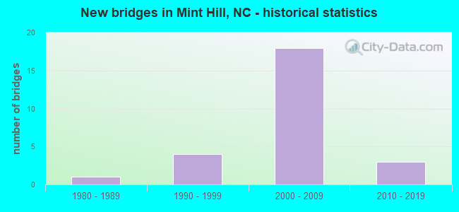
- New bridges - historical statistics
- 11980-1989
- 41990-1999
- 182000-2009
- 32010-2019
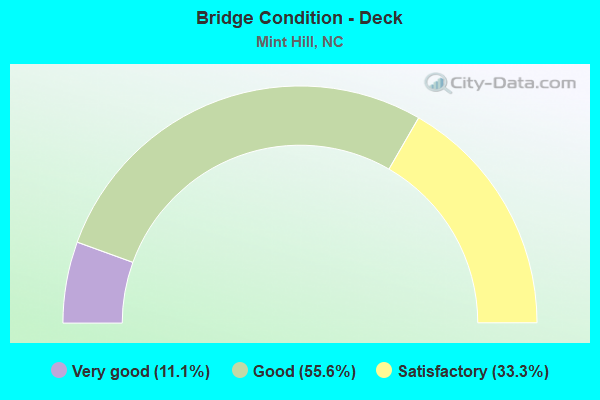
- Bridge Condition - Deck
- 11.1%Very good
- 55.6%Good
- 33.3%Satisfactory
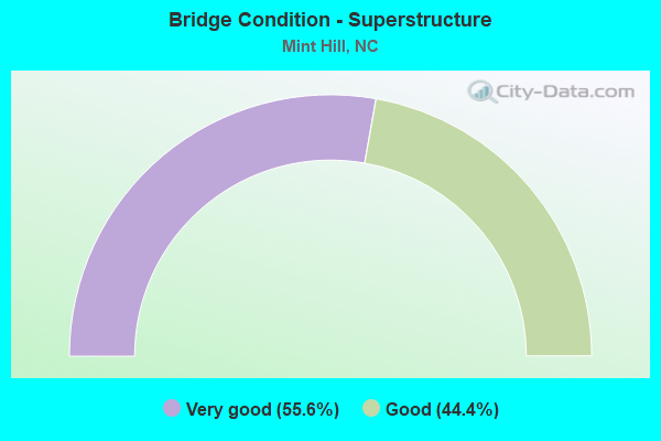
- Bridge Condition - Superstructure
- 55.6%Very good
- 44.4%Good
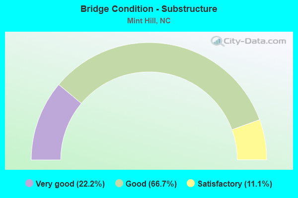
- Bridge Condition - Substructure
- 22.2%Very good
- 66.7%Good
- 11.1%Satisfactory
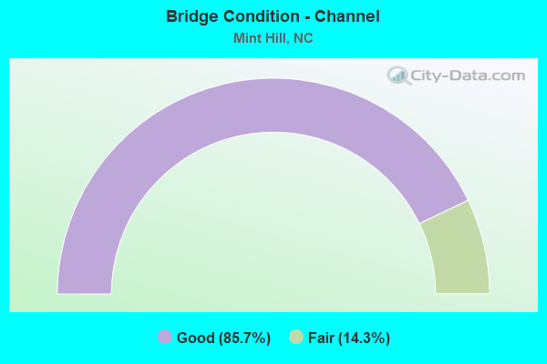
- Bridge Condition - Channel
- 85.7%Good
- 14.3%Fair
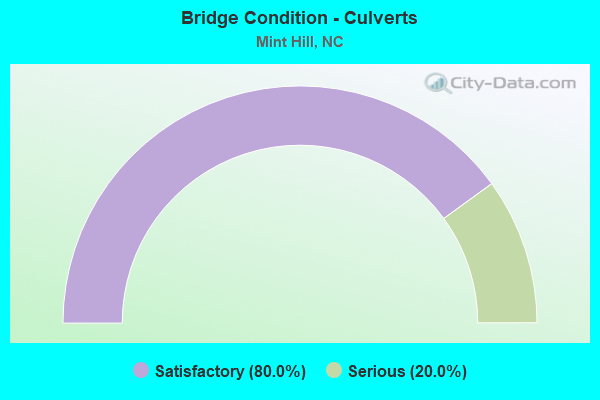
- Bridge Condition - Culverts
- 80.0%Satisfactory
- 20.0%Serious
Find on map >> Show street view
Structure Number: 1190036, Location: 1.0 MI. S. JCT. SR3156 (Lat: 35.166300, Lng: -80.689586), Route carried "on" structure: State highway 3135, Year Built: 2011, Status: Open, Structure Length: 2.89m (9.48ft), Average Daily Traffic: 5,800 (year 2012), Truck Traffic: 7%, Average Future Daily Traffic: 11,600 (year 2040), Design Load: HL 93, Features Intersected: IRVINS CREEK
Minimum Vertical Clearance: 30+ m (98+ ft), Kilometerpoint: 0.000, Lanes on structure: 2, Owner: State Highway Agency, Approaching Roadway Width: 7.9m (25.9ft), Skew: 1 degrees, Material/Design: Prestressed concrete, Design/Construction: Slab, Number Of Spans In Main Unit: 3, Length of Maximum Span: 13.4m (44.0ft), Curb or Sidewalk Widths: Left: 1.7m (5.6ft), Right: 1.7m (5.6ft), Curb-To-Curb Width: 14.0m (45.9ft), Out-to-Out Width: 18.2m (59.7ft)
Condition: Deck: Good, Superstructure: Good, Substructure: Very good, Channel: Good, Operating Rating: 54.4 metric tons, Method Used To Determine Operating Rating: Load and Resistance Factor (LRFR), Inventory Rating: 40.8 metric tons, Method Used To Determine Inventory Rating: Load and Resistance Factor (LRFR), Structural Evaluation: Better than present minimum criteria, Deck Geometry: Superior to present desirable criteria, Waterway Adequacy: Better than present minimum criteria, Approach Roadway Alignment: Equal to present desirable criteria, Designated Inspection Frequency: Every 24 months, Inspection Date: May 2020, Deck Structure Type: Concrete Precast Panels, Wearing Surface/Protective System: Wearing Surface: Integral Concrete
Find on map >> Show street view
Structure Number: 1190065, Location: 0.8 MI. N. JCT. SR3106 (Lat: 35.194842, Lng: -80.607725), Route carried "on" structure: State highway 3110, Year Built: 1997, Status: Open, Structure Length: 4.17m (13.68ft), Average Daily Traffic: 520 (year 2014), Truck Traffic: 7%, Average Future Daily Traffic: 1,040 (year 2040), Design Load: HS 20+Mod, Features Intersected: CLEAR CREEK
Minimum Vertical Clearance: 30+ m (98+ ft), Kilometerpoint: 0.000, Lanes on structure: 2, Owner: State Highway Agency, Approaching Roadway Width: 7.3m (24.0ft), Skew: 1 degrees, Material/Design: Prestressed concrete, Design/Construction: Slab, Number Of Spans In Main Unit: 3, Length of Maximum Span: 13.4m (44.0ft), Curb-To-Curb Width: 7.3m (24.0ft), Out-to-Out Width: 8.2m (26.9ft)
Condition: Deck: Very good, Superstructure: Very good, Substructure: Very good, Channel: Good, Operating Rating: 78.9 metric tons, Method Used To Determine Operating Rating: Load Factor (LF), Inventory Rating: 47.1 metric tons, Method Used To Determine Inventory Rating: Load Factor (LF), Structural Evaluation: Equal to present desirable criteria, Deck Geometry: Meets minimum limits, Waterway Adequacy: Better than present minimum criteria, Approach Roadway Alignment: Equal to present desirable criteria, Designated Inspection Frequency: Every 24 months, Inspection Date: April 2021, Deck Structure Type: Concrete Precast Panels, Wearing Surface/Protective System: Wearing Surface: Bituminous
Find on map >> Show street view
Structure Number: 1190125, Location: 0.33 MI. S. JCT. SR3114 (Lat: 35.203822, Lng: -80.633017), Route carried "on" structure: Interstate 485, Year Built: 2004, Status: Open, Structure Length: 1.37m (4.49ft), Average Daily Traffic: 57,000 (year 2015), Truck Traffic: 16%, Average Future Daily Traffic: 114,000 (year 2040), Design Load: HS 20+Mod, Features Intersected: UT TO CLEAR CREEK
Minimum Vertical Clearance: 30+ m (98+ ft), Kilometerpoint: 12.984, Lanes on structure: 8, Base Highway Network: Yes (Inventory Route: 1, Subroute: 85), Owner: State Highway Agency, Approaching Roadway Width: 51.8m (169.9ft), Skew: 22 degrees, Material/Design: Concrete continuous, Design/Construction: Culvert, Number Of Spans In Main Unit: 3, Length of Maximum Span: 3.0m (9.8ft)
Condition: Channel: Good, Culverts: Satisfactory, Operating Rating: 41.7 metric tons, Method Used To Determine Operating Rating: Field evaluation and documented engineering judgment, Inventory Rating: 32.6 metric tons, Method Used To Determine Inventory Rating: Field evaluation and documented engineering judgment, Structural Evaluation: Equal to present minimum criteria, Waterway Adequacy: Better than present minimum criteria, Approach Roadway Alignment: Equal to present desirable criteria, Designated Inspection Frequency: Every 24 months, Inspection Date: May 2020
Find on map >> Show street view
Structure Number: 1190546, Location: 0.15 MI. N. JCT. SR4274 (Lat: 35.174200, Lng: -80.599586), Route carried "on" structure: City street , Year Built: 1988, Status: Open, Structure Length: 0.91m (2.99ft), Average Daily Traffic: 100 (year 1989), Average Future Daily Traffic: 200 (year 2040), Design Load: HS 20+Mod, Features Intersected: UT TO DUCK CREEK, Facility Carried by Structure: HANGING MOSS TRL
Minimum Vertical Clearance: 30+ m (98+ ft), Kilometerpoint: 0.000, Lanes on structure: 2, Owner: City or Municipal Highway Agency, Approaching Roadway Width: 8.5m (27.9ft), Skew: 4 degrees, Material/Design: Steel, Design/Construction: Culvert, Number Of Spans In Main Unit: 2, Length of Maximum Span: 2.7m (8.9ft)
Condition: Channel: Fair, Culverts: Serious, Operating Rating: 89.8 metric tons, Method Used To Determine Operating Rating: Load and Resistance Factor (LRFR), Inventory Rating: 89.8 metric tons, Method Used To Determine Inventory Rating: Load and Resistance Factor (LRFR), Structural Evaluation: High priority of corrective action, Waterway Adequacy: Better than present minimum criteria, Approach Roadway Alignment: Equal to present desirable criteria, Designated Inspection Frequency: Every 24 months, Inspection Date: May 2020
Find on map >> Show street view
Structure Number: 119084, Location: 0.4 MI. W. JCT. SR1172 (Lat: 35.284089, Lng: -80.675753), Route carried "on" structure: State highway 2802, Year Built: 2003, Status: Open, Structure Length: 7.89m (25.89ft), Average Daily Traffic: 14,000 (year 2012), Truck Traffic: 7%, Average Future Daily Traffic: 28,000 (year 2040), Design Load: HS 20+Mod, Features Intersected: I485
Minimum Vertical Clearance: 30+ m (98+ ft), Kilometerpoint: 0.000, Lanes on structure: 4, Lanes under structure: 6, Owner: State Highway Agency, Approaching Roadway Width: 17.0m (55.8ft), Material/Design: Steel continuous, Design/Construction: Stringer/Multi-beam, Number Of Spans In Main Unit: 2, Length of Maximum Span: 39.0m (128.0ft), Curb-To-Curb Width: 18.1m (59.4ft), Out-to-Out Width: 19.2m (63.0ft)
Condition: Deck: Satisfactory, Superstructure: Very good, Substructure: Satisfactory, Operating Rating: 81.6 metric tons, Method Used To Determine Operating Rating: Load Factor (LF), Inventory Rating: 48.9 metric tons, Method Used To Determine Inventory Rating: Load Factor (LF), Structural Evaluation: Equal to present minimum criteria, Deck Geometry: Somewhat better than minimum adequacy, Underclear: Equal to present minimum criteria, Approach Roadway Alignment: Equal to present desirable criteria, Designated Inspection Frequency: Every 24 months, Inspection Date: June 2020, Deck Structure Type: Concrete Cast-file-Place, Wearing Surface/Protective System: Wearing Surface: Monolithic Concrete, Deck Protection: Epoxy Coated Reinforcing
Find on map >> Show street view
Structure Number: 1190845, Location: 1.0 MI. E. JCT. NC51 (Lat: 35.178975, Lng: -80.629569), Route carried "on" structure: State highway 218, Year Built: 2004, Status: Open, Structure Length: 8.26m (27.10ft), Average Daily Traffic: 22,500 (year 2018), Truck Traffic: 6%, Average Future Daily Traffic: 45,000 (year 2040), Design Load: HS 20+Mod, Features Intersected: I485
Minimum Vertical Clearance: 30+ m (98+ ft), Kilometerpoint: 0.000, Lanes on structure: 4, Lanes under structure: 4, Base Highway Network: Yes (Inventory Route: 3, Subroute: 18), Owner: State Highway Agency, Approaching Roadway Width: 21.9m (71.9ft), Skew: 23 degrees, Material/Design: Steel continuous, Design/Construction: Stringer/Multi-beam, Number Of Spans In Main Unit: 2, Length of Maximum Span: 39.6m (129.9ft), Curb-To-Curb Width: 25.7m (84.3ft), Out-to-Out Width: 26.5m (86.9ft)
Condition: Deck: Good, Superstructure: Very good, Substructure: Good, Operating Rating: 84.3 metric tons, Method Used To Determine Operating Rating: Load Factor (LF), Inventory Rating: 49.8 metric tons, Method Used To Determine Inventory Rating: Load Factor (LF), Structural Evaluation: Better than present minimum criteria, Deck Geometry: Superior to present desirable criteria, Underclear: Equal to present minimum criteria, Approach Roadway Alignment: Equal to present desirable criteria, Designated Inspection Frequency: Every 24 months, Inspection Date: June 2020, Deck Structure Type: Concrete Cast-file-Place, Wearing Surface/Protective System: Wearing Surface: Monolithic Concrete, Deck Protection: Epoxy Coated Reinforcing
Find on map >> Show street view
Structure Number: 1190846, Location: 0.1 MI. W. JCT. NC218 (Lat: 35.182658, Lng: -80.629531), Route carried "on" structure: City street , Year Built: 2004, Status: Open, Structure Length: 9.35m (30.68ft), Average Daily Traffic: 1,300 (year 2012), Truck Traffic: 7%, Average Future Daily Traffic: 2,600 (year 2040), Design Load: HS 20+Mod, Features Intersected: I485, Facility Carried by Structure: BARTLETT ROAD
Minimum Vertical Clearance: 30+ m (98+ ft), Kilometerpoint: 0.000, Lanes on structure: 2, Lanes under structure: 6, Owner: State Highway Agency, Approaching Roadway Width: 7.3m (24.0ft), Skew: 3 degrees, Material/Design: Steel continuous, Design/Construction: Stringer/Multi-beam, Number Of Spans In Main Unit: 2, Length of Maximum Span: 47.8m (156.8ft), Curb-To-Curb Width: 9.1m (29.9ft), Out-to-Out Width: 10.1m (33.1ft)
Condition: Deck: Good, Superstructure: Very good, Substructure: Good, Operating Rating: 89.8 metric tons, Method Used To Determine Operating Rating: Load Factor (LF), Inventory Rating: 67.1 metric tons, Method Used To Determine Inventory Rating: Load Factor (LF), Structural Evaluation: Better than present minimum criteria, Deck Geometry: Somewhat better than minimum adequacy, Underclear: Equal to present minimum criteria, Approach Roadway Alignment: Equal to present desirable criteria, Designated Inspection Frequency: Every 24 months, Inspection Date: June 2020, Deck Structure Type: Concrete Cast-file-Place, Wearing Surface/Protective System: Wearing Surface: Monolithic Concrete, Deck Protection: Epoxy Coated Reinforcing
Find on map >> Show street view
Structure Number: 1190847, Location: 1.6 MI. S. JCT. NC24/27 (Lat: 35.202036, Lng: -80.633364), Route carried "on" structure: State highway 51, Year Built: 2004, Status: Open, Structure Length: 9.78m (32.09ft), Average Daily Traffic: 13,000 (year 2018), Truck Traffic: 12%, Average Future Daily Traffic: 26,000 (year 2040), Design Load: HS 20+Mod, Features Intersected: I485
Minimum Vertical Clearance: 30+ m (98+ ft), Kilometerpoint: 13.045, Lanes on structure: 4, Lanes under structure: 4, Base Highway Network: Yes (Inventory Route: 3, Subroute: 51), Owner: State Highway Agency, Approaching Roadway Width: 25.6m (84.0ft), Skew: 23 degrees, Material/Design: Steel continuous, Design/Construction: Stringer/Multi-beam, Number Of Spans In Main Unit: 2, Length of Maximum Span: 51.2m (168.0ft), Curb-To-Curb Width: 25.6m (84.0ft), Out-to-Out Width: 26.7m (87.6ft)
Condition: Deck: Good, Superstructure: Good, Substructure: Good, Operating Rating: 68.0 metric tons, Method Used To Determine Operating Rating: Load Factor (LF), Inventory Rating: 40.8 metric tons, Method Used To Determine Inventory Rating: Load Factor (LF), Structural Evaluation: Better than present minimum criteria, Deck Geometry: Superior to present desirable criteria, Underclear: Equal to present minimum criteria, Approach Roadway Alignment: Equal to present desirable criteria, Designated Inspection Frequency: Every 24 months, Inspection Date: June 2020, Deck Structure Type: Concrete Cast-file-Place, Wearing Surface/Protective System: Wearing Surface: Monolithic Concrete, Deck Protection: Epoxy Coated Reinforcing
Find on map >> Show street view
Structure Number: 119085, Location: 0.36 MI. E. JCT SR-5203 (Lat: 35.208558, Lng: -80.640136), Route carried "on" structure: City street , Year Built: 2001, Status: Open, Structure Length: 8.62m (28.28ft), Average Daily Traffic: 100 (year 2018), Truck Traffic: 7%, Average Future Daily Traffic: 200 (year 2040), Design Load: HS 20+Mod, Features Intersected: I485, Facility Carried by Structure: TRUELIGHT CHURCH
Minimum Vertical Clearance: 30+ m (98+ ft), Kilometerpoint: 0.000, Lanes on structure: 2, Lanes under structure: 4, Owner: State Highway Agency, Approaching Roadway Width: 8.5m (27.9ft), Skew: 3 degrees, Material/Design: Steel continuous, Design/Construction: Stringer/Multi-beam, Number Of Spans In Main Unit: 2, Length of Maximum Span: 42.9m (140.7ft), Curb-To-Curb Width: 8.9m (29.2ft), Out-to-Out Width: 9.9m (32.5ft)
Condition: Deck: Satisfactory, Superstructure: Very good, Substructure: Good, Operating Rating: 75.2 metric tons, Method Used To Determine Operating Rating: Load Factor (LF), Inventory Rating: 44.4 metric tons, Method Used To Determine Inventory Rating: Load Factor (LF), Structural Evaluation: Better than present minimum criteria, Deck Geometry: Better than present minimum criteria, Underclear: Equal to present minimum criteria, Approach Roadway Alignment: Equal to present desirable criteria, Designated Inspection Frequency: Every 24 months, Inspection Date: April 2021, Deck Structure Type: Concrete Cast-file-Place, Wearing Surface/Protective System: Wearing Surface: Monolithic Concrete
Find on map >> Show street view
Structure Number: 1190852, Location: 1.6 MI. W. JCT. NC51 (Lat: 35.219675, Lng: -80.649356), Route carried "on" structure: State highway 24, Year Built: 2003, Status: Open, Structure Length: 7.83m (25.69ft), Average Daily Traffic: 24,000 (year 2018), Truck Traffic: 12%, Average Future Daily Traffic: 48,000 (year 2040), Design Load: HS 20+Mod, Features Intersected: I485
Minimum Vertical Clearance: 30+ m (98+ ft), Kilometerpoint: 0.000, Lanes on structure: 4, Lanes under structure: 6, Base Highway Network: Yes (Inventory Route: 3, Subroute: 24), Owner: State Highway Agency, Approaching Roadway Width: 29.2m (95.8ft), Skew: 20 degrees, Material/Design: Steel continuous, Design/Construction: Stringer/Multi-beam, Number Of Spans In Main Unit: 2, Length of Maximum Span: 38.7m (127.0ft), Curb or Sidewalk Widths: Left: 1.5m (4.9ft), Right: 0.0m, Curb-To-Curb Width: 27.1m (88.9ft), Out-to-Out Width: 29.5m (96.8ft)
Condition: Deck: Good, Superstructure: Good, Substructure: Good, Operating Rating: 84.3 metric tons, Method Used To Determine Operating Rating: Load Factor (LF), Inventory Rating: 49.8 metric tons, Method Used To Determine Inventory Rating: Load Factor (LF), Structural Evaluation: Better than present minimum criteria, Deck Geometry: Superior to present desirable criteria, Underclear: Equal to present minimum criteria, Approach Roadway Alignment: Equal to present desirable criteria, Designated Inspection Frequency: Every 24 months, Inspection Date: June 2020, Deck Structure Type: Concrete Cast-file-Place, Wearing Surface/Protective System: Wearing Surface: Monolithic Concrete, Deck Protection: Epoxy Coated Reinforcing
Find on map >> Show street view
Structure Number: 1190925, Location: 0.1 MI. N. JCT. SR3124 (Lat: 35.146772, Lng: -80.630642), Route carried "on" structure: State highway 1004, Year Built: 1999, Status: Open, Structure Length: 6.79m (22.28ft), Average Daily Traffic: 18,000 (year 2014), Truck Traffic: 6%, Average Future Daily Traffic: 36,000 (year 2040), Design Load: HS 20+Mod, Features Intersected: I485
Minimum Vertical Clearance: 30+ m (98+ ft), Kilometerpoint: 0.000, Lanes on structure: 2, Lanes under structure: 4, Owner: State Highway Agency, Approaching Roadway Width: 20.7m (67.9ft), Skew: 20 degrees, Material/Design: Steel continuous, Design/Construction: Stringer/Multi-beam, Number Of Spans In Main Unit: 2, Length of Maximum Span: 34.1m (111.9ft), Curb-To-Curb Width: 24.4m (80.1ft), Out-to-Out Width: 25.5m (83.7ft)
Condition: Deck: Satisfactory, Superstructure: Good, Substructure: Good, Operating Rating: 85.2 metric tons, Method Used To Determine Operating Rating: Load Factor (LF), Inventory Rating: 50.8 metric tons, Method Used To Determine Inventory Rating: Load Factor (LF), Structural Evaluation: Better than present minimum criteria, Deck Geometry: Superior to present desirable criteria, Underclear: Somewhat better than minimum adequacy, Approach Roadway Alignment: Equal to present desirable criteria, Designated Inspection Frequency: Every 24 months, Inspection Date: Febuary 2021, Deck Structure Type: Concrete Cast-file-Place, Wearing Surface/Protective System: Wearing Surface: Monolithic Concrete
Find on map >> Show street view
Structure Number: 1190991, Location: 0.16 MI. N. JCT. SR1004 (Lat: 35.141892, Lng: -80.637300), Route carried "on" structure: Interstate 485, Year Built: 2000, Status: Open, Structure Length: 1.12m (3.67ft), Average Daily Traffic: 61,000 (year 2015), Truck Traffic: 16%, Average Future Daily Traffic: 122,000 (year 2040), Design Load: HS 20+Mod, Features Intersected: GOOSE CREEK
Minimum Vertical Clearance: 30+ m (98+ ft), Kilometerpoint: 14.386, Lanes on structure: 4, Base Highway Network: Yes (Inventory Route: 1, Subroute: 85), Owner: State Highway Agency, Approaching Roadway Width: 26.8m (87.9ft), Skew: 22 degrees, Material/Design: Concrete continuous, Design/Construction: Culvert, Number Of Spans In Main Unit: 3, Length of Maximum Span: 3.3m (10.8ft)
Condition: Channel: Good, Culverts: Satisfactory, Operating Rating: 89.8 metric tons, Method Used To Determine Operating Rating: Load and Resistance Factor (LRFR), Inventory Rating: 76.2 metric tons, Method Used To Determine Inventory Rating: Load and Resistance Factor (LRFR), Structural Evaluation: Equal to present minimum criteria, Waterway Adequacy: Better than present minimum criteria, Approach Roadway Alignment: Equal to present desirable criteria, Designated Inspection Frequency: Every 24 months, Inspection Date: Febuary 2021
Find on map >> Show street view
Structure Number: 1191535, Location: .15MI.S.OF JCT.W.PINE LK. (Lat: 35.170356, Lng: -80.680692), Route carried "on" structure: City street , Year Built: 2019, Status: Open, Structure Length: 0.82m (2.69ft), Average Daily Traffic: 100 (year 2018), Truck Traffic: 7%, Average Future Daily Traffic: 200 (year 2040), Design Load: HS 20+Mod, Features Intersected: IRVINS CREEK, Facility Carried by Structure: BEAVER DAM LANE
Minimum Vertical Clearance: 30+ m (98+ ft), Kilometerpoint: 0.000, Lanes on structure: 2, Owner: City or Municipal Highway Agency, Approaching Roadway Width: 7.3m (24.0ft), Material/Design: Aluminum, Iron, Design/Construction: Culvert, Number Of Spans In Main Unit: 1, Length of Maximum Span: 8.2m (26.9ft)
Condition: Channel: Good, Culverts: Satisfactory, Operating Rating: 89.8 metric tons, Method Used To Determine Operating Rating: Load and Resistance Factor (LRFR), Inventory Rating: 89.8 metric tons, Method Used To Determine Inventory Rating: Load and Resistance Factor (LRFR), Structural Evaluation: Equal to present minimum criteria, Waterway Adequacy: Equal to present desirable criteria, Approach Roadway Alignment: Equal to present desirable criteria, Designated Inspection Frequency: Every 24 months, Inspection Date: May 2020
Find on map >> Show street view
Structure Number: 1191536, Location: .35MI.W.OF JCT.W.NC51 (Lat: 35.199308, Lng: -80.641336), Route carried "on" structure: City street , Year Built: 2019, Status: Open, Structure Length: 0.64m (2.10ft), Average Daily Traffic: 100 (year 2018), Truck Traffic: 7%, Average Future Daily Traffic: 200 (year 2040), Design Load: HS 20+Mod, Features Intersected: UNKNOWN CREEK, Facility Carried by Structure: BRAINVIEW DR.
Minimum Vertical Clearance: 30+ m (98+ ft), Kilometerpoint: 0.000, Lanes on structure: 2, Owner: City or Municipal Highway Agency, Approaching Roadway Width: 9.7m (31.8ft), Material/Design: Prestressed concrete, Design/Construction: Culvert, Number Of Spans In Main Unit: 1, Length of Maximum Span: 6.0m (19.7ft)
Condition: Channel: Good, Culverts: Satisfactory, Operating Rating: 41.7 metric tons, Method Used To Determine Operating Rating: Field evaluation and documented engineering judgment, Inventory Rating: 32.6 metric tons, Method Used To Determine Inventory Rating: Field evaluation and documented engineering judgment, Structural Evaluation: Equal to present minimum criteria, Waterway Adequacy: Equal to present desirable criteria, Approach Roadway Alignment: Equal to present desirable criteria, Designated Inspection Frequency: Every 24 months, Inspection Date: May 2020
Find on map >> Show street view
Structure Number: 1190845, Location: 1.0 MI. E. JCT. NC51 (Lat: 35.178975, Lng: -80.629569), Route carried "under" structure: Interstate 485, Year Built: 2004, Structure Length: 0. m, Average Daily Traffic: 34,000 (year 2018), Truck Traffic: 16%, Features Intersected: NC218
Minimum Vertical Clearance: 5.34m (17.52ft), Kilometerpoint: 13.886, Lanes on structure: 4, Lanes under structure: 2, Material/Design: Steel continuous, Design/Construction: Stringer/Multi-beam, Length of Maximum Span: 39.6m (129.9ft)
Find on map >> Show street view
Structure Number: 1190845, Location: 1.0 MI. E. JCT. NC51 (Lat: 35.178975, Lng: -80.629569), Route carried "under" structure: Interstate 485, Year Built: 2004, Structure Length: 0. m, Average Daily Traffic: 34,000 (year 2018), Truck Traffic: 16%, Features Intersected: NC218, Facility Carried by Structure: I48N
Minimum Vertical Clearance: 5.25m (17.22ft), Kilometerpoint: 13.886, Lanes on structure: 4, Lanes under structure: 2, Material/Design: Steel continuous, Design/Construction: Stringer/Multi-beam, Length of Maximum Span: 39.6m (129.9ft)
Find on map >> Show street view
Structure Number: 1190846, Location: 0.1 MI. W. JCT. NC218 (Lat: 35.182658, Lng: -80.629531), Route carried "under" structure: Interstate 485, Year Built: 2004, Structure Length: 0. m, Average Daily Traffic: 34,000 (year 2018), Truck Traffic: 16%, Features Intersected: BARTLETT ROAD
Minimum Vertical Clearance: 5.33m (17.49ft), Kilometerpoint: 13.466, Lanes on structure: 2, Lanes under structure: 3, Material/Design: Steel continuous, Design/Construction: Stringer/Multi-beam, Length of Maximum Span: 47.8m (156.8ft)
Find on map >> Show street view
Structure Number: 1190846, Location: 0.1 MI. W. JCT. NC218 (Lat: 35.182658, Lng: -80.629531), Route carried "under" structure: Interstate 485, Year Built: 2004, Structure Length: 0. m, Average Daily Traffic: 34,000 (year 2018), Truck Traffic: 16%, Features Intersected: BARTLETT ROAD
Minimum Vertical Clearance: 5.34m (17.52ft), Kilometerpoint: 13.466, Lanes on structure: 2, Lanes under structure: 3, Material/Design: Steel continuous, Design/Construction: Stringer/Multi-beam, Length of Maximum Span: 47.8m (156.8ft)
Find on map >> Show street view
Structure Number: 1190847, Location: 1.6 MI. S. JCT. NC24/27 (Lat: 35.202036, Lng: -80.633364), Route carried "under" structure: Interstate 485, Year Built: 2004, Structure Length: 0. m, Average Daily Traffic: 34,000 (year 2018), Truck Traffic: 16%, Features Intersected: NC51
Minimum Vertical Clearance: 6.88m (22.57ft), Kilometerpoint: 13.033, Lanes on structure: 4, Lanes under structure: 2, Material/Design: Steel continuous, Design/Construction: Stringer/Multi-beam, Length of Maximum Span: 51.2m (168.0ft)
Find on map >> Show street view
Structure Number: 1190847, Location: 1.6 MI. S. JCT. NC24/27 (Lat: 35.202036, Lng: -80.633364), Route carried "under" structure: Interstate 485, Year Built: 2004, Structure Length: 0. m, Average Daily Traffic: 20,500 (year 2013), Truck Traffic: 16%, Features Intersected: NC51
Minimum Vertical Clearance: 5.27m (17.29ft), Kilometerpoint: 13.033, Lanes on structure: 4, Lanes under structure: 2, Material/Design: Steel continuous, Design/Construction: Stringer/Multi-beam, Length of Maximum Span: 51.2m (168.0ft)
Find on map >> Show street view
Structure Number: 119085, Location: 0.36 MI. E. JCT SR-5203 (Lat: 35.208558, Lng: -80.640136), Route carried "under" structure: Interstate 485, Year Built: 2001, Structure Length: 0. m, Average Daily Traffic: 27,500 (year 2015), Truck Traffic: 16%, Features Intersected: TRUELIGHT CHURCH
Minimum Vertical Clearance: 5.20m (17.06ft), Kilometerpoint: 12.862, Lanes on structure: 2, Lanes under structure: 2, Material/Design: Steel continuous, Design/Construction: Stringer/Multi-beam, Length of Maximum Span: 42.9m (140.7ft)
Find on map >> Show street view
Structure Number: 119085, Location: 0.36 MI. E. JCT SR-5203 (Lat: 35.208558, Lng: -80.640136), Route carried "under" structure: Interstate 485, Year Built: 2001, Structure Length: 0. m, Average Daily Traffic: 27,500 (year 2015), Truck Traffic: 16%, Features Intersected: TRUELIGHT CHURCH
Minimum Vertical Clearance: 5.40m (17.72ft), Kilometerpoint: 12.862, Lanes on structure: 2, Lanes under structure: 2, Material/Design: Steel continuous, Design/Construction: Stringer/Multi-beam, Length of Maximum Span: 42.9m (140.7ft)
Find on map >> Show street view
Structure Number: 1190852, Location: 1.6 MI. W. JCT. NC51 (Lat: 35.219675, Lng: -80.649356), Route carried "under" structure: Interstate 485, Year Built: 2003, Structure Length: 0. m, Average Daily Traffic: 32,500 (year 2018), Truck Traffic: 16%, Features Intersected: NC24/27
Minimum Vertical Clearance: 7.55m (24.77ft), Kilometerpoint: 12.570, Lanes on structure: 4, Lanes under structure: 3, Material/Design: Steel continuous, Design/Construction: Stringer/Multi-beam, Length of Maximum Span: 38.7m (127.0ft)
Find on map >> Show street view
Structure Number: 1190852, Location: 1.6 MI. W. JCT. NC51 (Lat: 35.219675, Lng: -80.649356), Route carried "under" structure: Interstate 485, Year Built: 2003, Structure Length: 0. m, Average Daily Traffic: 32,500 (year 2018), Truck Traffic: 16%, Features Intersected: NC24/27
Minimum Vertical Clearance: 7.43m (24.38ft), Kilometerpoint: 12.570, Lanes on structure: 4, Lanes under structure: 3, Material/Design: Steel continuous, Design/Construction: Stringer/Multi-beam, Length of Maximum Span: 38.7m (127.0ft)
Find on map >> Show street view
Structure Number: 1190925, Location: 0.1 MI. N. JCT. SR3124 (Lat: 35.146772, Lng: -80.630642), Route carried "under" structure: Interstate 485, Year Built: 1999, Structure Length: 0. m, Average Daily Traffic: 29,500 (year 2015), Truck Traffic: 16%, Features Intersected: SR1004
Minimum Vertical Clearance: 5.28m (17.32ft), Kilometerpoint: 14.173, Lanes on structure: 2, Lanes under structure: 2, Material/Design: Steel continuous, Design/Construction: Stringer/Multi-beam, Length of Maximum Span: 34.1m (111.9ft)
Find on map >> Show street view
Structure Number: 1190925, Location: 0.1 MI. N. JCT. SR3124 (Lat: 35.146772, Lng: -80.630642), Route carried "under" structure: Interstate 485, Year Built: 1999, Structure Length: 0. m, Average Daily Traffic: 29,500 (year 2015), Truck Traffic: 16%, Features Intersected: SR1004
Minimum Vertical Clearance: 5.89m (19.32ft), Kilometerpoint: 14.173, Lanes on structure: 2, Lanes under structure: 2, Material/Design: Steel continuous, Design/Construction: Stringer/Multi-beam, Length of Maximum Span: 34.1m (111.9ft)