Bridge Statistics for Mitchell, Nebraska (NE)
Condition, Traffic, Stress, Structural Evaluation, Project Costs
- National Bridge Inventory (NBI) Statistics
- 32Number of bridges
- 233ft / 71.3mTotal length
- 28,875Total average daily traffic
- 1,800Total average daily truck traffic
- 39,486Total future (year 2033) average daily traffic
- National Bridge Inventory (NBI) Registered Bridges for Mitchell
- No street view available for this location
- New bridges - historical statistics
- 21910-1919
- 91930-1939
- 11940-1949
- 11960-1969
- 51970-1979
- 71980-1989
- 31990-1999
- 32000-2009
- 12010-2019
- Reconstructed bridges - Historical Statistics
- 21960-1969
- 11970-1979
- 11980-1989
- 01990-1999
- 12000-2009
- 12010-2019
- Bridge Condition - Deck
- 31.8%Very good
- 27.3%Good
- 18.2%Satisfactory
- 18.2%Fair
- 4.5%Poor
- Bridge Condition - Superstructure
- 50.0%Very good
- 22.7%Good
- 9.1%Satisfactory
- 13.6%Fair
- 4.5%Poor
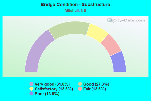
- Bridge Condition - Substructure
- 31.8%Very good
- 27.3%Good
- 13.6%Satisfactory
- 13.6%Fair
- 13.6%Poor
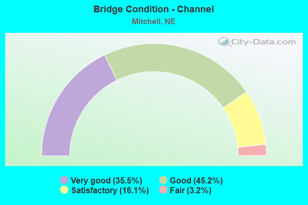
- Bridge Condition - Channel
- 35.5%Very good
- 45.2%Good
- 16.1%Satisfactory
- 3.2%Fair

- Bridge Condition - Culverts
- 10.0%Excellent
- 30.0%Very good
- 50.0%Good
- 10.0%Satisfactory
Find on map >> Show street view
Structure Number: C00790021, Location: 1W N29 SIOUX CL (Lat: 42.000700, Lng: -103.829200), Route carried "on" structure: County highway 1, Year Built: 1935, Status: Posted for load, Structure Length: 0.94m (3.08ft), Average Daily Traffic: 50 (year 2003), Average Future Daily Traffic: 85 (year 2033), Features Intersected: DRY SPOTTED TAIL CREEK, Facility Carried by Structure: COUNTY ROAD A
Minimum Vertical Clearance: 30+ m (98+ ft), Kilometerpoint: 0.000, Lanes on structure: 2, Owner: County Highway Agency, Approaching Roadway Width: 7.3m (24.0ft), Material/Design: Wood or Timber, Design/Construction: Stringer/Multi-beam, Number Of Spans In Main Unit: 2, Length of Maximum Span: 4.6m (15.1ft), Curb-To-Curb Width: 6.1m (20.0ft), Out-to-Out Width: 6.2m (20.3ft)
Condition: Deck: Good, Superstructure: Good, Substructure: Satisfactory, Channel: Good, Operating Rating: 28.0 metric tons, Method Used To Determine Operating Rating: Allowable Stress (AS), Inventory Rating: 20.0 metric tons, Method Used To Determine Inventory Rating: Allowable Stress (AS), Structural Evaluation: Somewhat better than minimum adequacy, Deck Geometry: Somewhat better than minimum adequacy, Waterway Adequacy: Somewhat better than minimum adequacy, Approach Roadway Alignment: Equal to present minimum criteria, Bridge Posting: Required (Relationship of Operating Rating to Maximum Legal Load: 10.0 - 19.9% below), Designated Inspection Frequency: Every 24 months, Inspection Date: November 2020, Deck Structure Type: Wood or Timber, Wearing Surface/Protective System: Wearing Surface: Wood or Timber
Find on map >> Show street view
Structure Number: C007900213, Location: 1E N29 SIOUX CL (Lat: 42.001700, Lng: -103.788300), Route carried "on" structure: County highway 1, Year Built: 1988, Status: Open, Structure Length: 1.22m (4.00ft), Average Daily Traffic: 50 (year 2003), Average Future Daily Traffic: 85 (year 2033), Features Intersected: SPOTTEDTAIL CREEK, Facility Carried by Structure: COUNTY ROAD A
Minimum Vertical Clearance: 30+ m (98+ ft), Kilometerpoint: 0.000, Lanes on structure: 2, Owner: County Highway Agency, Approaching Roadway Width: 6.7m (22.0ft), Material/Design: Steel, Design/Construction: Stringer/Multi-beam, Number Of Spans In Main Unit: 1, Length of Maximum Span: 11.6m (38.1ft), Curb-To-Curb Width: 8.4m (27.6ft), Out-to-Out Width: 8.6m (28.2ft)
Condition: Deck: Very good, Superstructure: Very good, Substructure: Very good, Channel: Very good, Operating Rating: 72.0 metric tons, Method Used To Determine Operating Rating: Load Factor (LF), Inventory Rating: 43.0 metric tons, Method Used To Determine Inventory Rating: Load Factor (LF), Structural Evaluation: Equal to present desirable criteria, Deck Geometry: Equal to present minimum criteria, Waterway Adequacy: Better than present minimum criteria, Approach Roadway Alignment: Equal to present desirable criteria, Designated Inspection Frequency: Every 24 months, Inspection Date: November 2021, Deck Structure Type: Concrete Cast-file-Place, Wearing Surface/Protective System: Wearing Surface: Monolithic Concrete
Find on map >> Show street view
Structure Number: C00790143, Location: 1.7S 2W OF MITCHELL (Lat: 41.915000, Lng: -103.833300), Route carried "on" structure: County highway 14, Year Built: 1986, Status: Open, Structure Length: 1.25m (4.10ft), Average Daily Traffic: 90 (year 2003), Average Future Daily Traffic: 153 (year 2033), Features Intersected: MITCHELL-GERING CANAL, Facility Carried by Structure: COUNTY ROAD G
Minimum Vertical Clearance: 30+ m (98+ ft), Kilometerpoint: 0.000, Lanes on structure: 2, Owner: County Highway Agency, Approaching Roadway Width: 6.1m (20.0ft), Skew: 1 degrees, Material/Design: Steel, Design/Construction: Stringer/Multi-beam, Number Of Spans In Main Unit: 1, Length of Maximum Span: 12.2m (40.0ft), Curb-To-Curb Width: 9.0m (29.5ft), Out-to-Out Width: 9.1m (29.9ft)
Condition: Deck: Good, Superstructure: Very good, Substructure: Very good, Channel: Very good, Operating Rating: 64.0 metric tons, Method Used To Determine Operating Rating: Load Factor (LF), Inventory Rating: 38.0 metric tons, Method Used To Determine Inventory Rating: Load Factor (LF), Structural Evaluation: Equal to present desirable criteria, Deck Geometry: Better than present minimum criteria, Waterway Adequacy: Better than present minimum criteria, Approach Roadway Alignment: Equal to present minimum criteria, Designated Inspection Frequency: Every 24 months, Inspection Date: November 2021, Deck Structure Type: Concrete Cast-file-Place, Wearing Surface/Protective System: Wearing Surface: Monolithic Concrete
Find on map >> Show street view
Structure Number: C007901635, Location: WJCT N29/N92 2N 1.3W (Lat: 41.901700, Lng: -103.838300), Route carried "on" structure: County highway 1070, Year Built: 1985, Status: Open, Structure Length: 1.58m (5.18ft), Average Daily Traffic: 130 (year 2011), Average Future Daily Traffic: 130 (year 2033), Design Load: HS 20, Features Intersected: MITCHELL-GERING CANAL, Facility Carried by Structure: COUNTRY ROAD H
Minimum Vertical Clearance: 30+ m (98+ ft), Kilometerpoint: 1.728, Lanes on structure: 2, Owner: County Highway Agency, Approaching Roadway Width: 7.3m (24.0ft), Skew: 4 degrees, Material/Design: Concrete, Design/Construction: Culvert, Number Of Spans In Main Unit: 3, Length of Maximum Span: 4.0m (13.1ft)
Condition: Channel: Good, Culverts: Good, Operating Rating: 33.0 metric tons, Method Used To Determine Operating Rating: Field evaluation and documented engineering judgment, Inventory Rating: 22.0 metric tons, Method Used To Determine Inventory Rating: Field evaluation and documented engineering judgment, Structural Evaluation: Equal to present minimum criteria, Waterway Adequacy: Equal to present desirable criteria, Approach Roadway Alignment: Superior to present desirable criteria, Designated Inspection Frequency: Every 24 months, Inspection Date: November 2020
Find on map >> Show street view
Structure Number: C007902505, Location: 3S 1W OF MITCHELL (Lat: 41.896300, Lng: -103.832800), Route carried "on" structure: County highway 25, Year Built: 1935, Status: Posted for load, Structure Length: 1.01m (3.31ft), Average Daily Traffic: 35 (year 2003), Average Future Daily Traffic: 59 (year 2033), Features Intersected: MITCHELL-GERING CANAL, Facility Carried by Structure: COUNTY ROAD 13
Minimum Vertical Clearance: 30+ m (98+ ft), Kilometerpoint: 0.000, Lanes on structure: 2, Owner: County Highway Agency, Approaching Roadway Width: 6.1m (20.0ft), Skew: 2 degrees, Material/Design: Wood or Timber, Design/Construction: Stringer/Multi-beam, Number Of Spans In Main Unit: 2, Length of Maximum Span: 5.2m (17.1ft), Curb-To-Curb Width: 6.1m (20.0ft), Out-to-Out Width: 6.1m (20.0ft)
Condition: Deck: Satisfactory, Superstructure: Fair, Substructure: Poor, Channel: Good, Operating Rating: 10.0 metric tons, Method Used To Determine Operating Rating: Allowable Stress (AS), Inventory Rating: 7.0 metric tons, Method Used To Determine Inventory Rating: Allowable Stress (AS), Structural Evaluation: High priority of replacement, Deck Geometry: Somewhat better than minimum adequacy, Waterway Adequacy: Somewhat better than minimum adequacy, Approach Roadway Alignment: Somewhat better than minimum adequacy, Bridge Posting: Required (Relationship of Operating Rating to Maximum Legal Load: > 39.9% below), Length Of Structure Improvement: 1.01m (3.31ft), Designated Inspection Frequency: Every 24 months, Inspection Date: November 2020, Deck Structure Type: Wood or Timber, Wearing Surface/Protective System: Wearing Surface: Wood or Timber
Find on map >> Show street view
Structure Number: C00790272, Location: 4S OF MITCHELL (Lat: 41.886000, Lng: -103.813100), Route carried "on" structure: County highway 1037, Year Built: 1948, Status: Open, Structure Length: 0.76m (2.49ft), Average Daily Traffic: 670 (year 2011), Average Future Daily Traffic: 670 (year 2033), Features Intersected: MITCHELL-GERING CANAL, Facility Carried by Structure: MITCHELL SOUTH
Minimum Vertical Clearance: 30+ m (98+ ft), Kilometerpoint: 0.143, Lanes on structure: 2, Owner: County Highway Agency, Approaching Roadway Width: 7.3m (24.0ft), Skew: 1 degrees, Material/Design: Concrete, Design/Construction: Culvert, Number Of Spans In Main Unit: 2, Length of Maximum Span: 3.7m (12.1ft)
Condition: Channel: Good, Culverts: Satisfactory, Operating Rating: 33.0 metric tons, Method Used To Determine Operating Rating: Field evaluation and documented engineering judgment, Inventory Rating: 22.0 metric tons, Method Used To Determine Inventory Rating: Field evaluation and documented engineering judgment, Structural Evaluation: Somewhat better than minimum adequacy, Waterway Adequacy: Meets minimum limits, Approach Roadway Alignment: Better than present minimum criteria, Designated Inspection Frequency: Every 24 months, Inspection Date: November 2020
Find on map >> Show street view
Structure Number: C007910405, Location: WJCT US26/N29 3N 1.3W (Lat: 41.986700, Lng: -103.838300), Route carried "on" structure: County highway 1090, Year Built: 1935, Year Reconstructed: 1982, Status: Open, Structure Length: 0.91m (2.99ft), Average Daily Traffic: 190 (year 2011), Average Future Daily Traffic: 190 (year 2033), Design Load: HS 20, Features Intersected: STREAM, Facility Carried by Structure: COUNTY ROAD B
Minimum Vertical Clearance: 30+ m (98+ ft), Kilometerpoint: 2.375, Lanes on structure: 2, Owner: County Highway Agency, Approaching Roadway Width: 7.9m (25.9ft), Material/Design: Steel, Design/Construction: Stringer/Multi-beam, Number Of Spans In Main Unit: 1, Length of Maximum Span: 8.5m (27.9ft), Curb-To-Curb Width: 9.1m (29.9ft), Out-to-Out Width: 9.1m (29.9ft)
Condition: Deck: Good, Superstructure: Very good, Substructure: Good, Channel: Good, Operating Rating: 43.0 metric tons, Method Used To Determine Operating Rating: Load Factor (LF), Inventory Rating: 25.0 metric tons, Method Used To Determine Inventory Rating: Load Factor (LF), Structural Evaluation: Equal to present minimum criteria, Deck Geometry: Equal to present minimum criteria, Waterway Adequacy: Better than present minimum criteria, Approach Roadway Alignment: Equal to present desirable criteria, Designated Inspection Frequency: Every 24 months, Inspection Date: November 2020, Deck Structure Type: Concrete Cast-file-Place, Wearing Surface/Protective System: Wearing Surface: Monolithic Concrete
Find on map >> Show street view
Structure Number: C00791041, Location: WJCT US26/N29 3N .9W (Lat: 41.986700, Lng: -103.831700), Route carried "on" structure: County highway 1090, Year Built: 1989, Year Reconstructed: 2013, Status: Open, Structure Length: 1.16m (3.81ft), Average Daily Traffic: 190 (year 2011), Average Future Daily Traffic: 190 (year 2033), Features Intersected: DRY SPOTTEDTAIL CREEK
Minimum Vertical Clearance: 30+ m (98+ ft), Kilometerpoint: 2.427, Lanes on structure: 2, Owner: County Highway Agency, Approaching Roadway Width: 8.5m (27.9ft), Skew: 1 degrees, Material/Design: Steel, Design/Construction: Stringer/Multi-beam, Number Of Spans In Main Unit: 2, Length of Maximum Span: 5.8m (19.0ft), Curb-To-Curb Width: 9.1m (29.9ft), Out-to-Out Width: 9.7m (31.8ft)
Condition: Deck: Very good, Superstructure: Very good, Substructure: Very good, Channel: Very good, Inventory Rating: 61.0 metric tons, Method Used To Determine Inventory Rating: Load and Resistance Factor (LRFR), Structural Evaluation: Equal to present desirable criteria, Deck Geometry: Equal to present minimum criteria, Waterway Adequacy: Equal to present desirable criteria, Approach Roadway Alignment: Equal to present desirable criteria, Length Of Structure Improvement: 1.19m (3.90ft), Designated Inspection Frequency: Every 24 months, Inspection Date: November 2021, Deck Structure Type: Concrete Cast-file-Place, Wearing Surface/Protective System: Wearing Surface: Monolithic Concrete, Deck Protection: Epoxy Coated Reinforcing
Find on map >> Show street view
Structure Number: C007910415, Location: WJCT US26/N29 3N .7E (Lat: 41.986700, Lng: -103.801700), Route carried "on" structure: County highway 1090, Year Built: 1971, Status: Open, Structure Length: 0.82m (2.69ft), Average Daily Traffic: 135 (year 2011), Average Future Daily Traffic: 135 (year 2033), Features Intersected: SPOTTED TAIL CREEK, Facility Carried by Structure: COUNTY ROAD B
Minimum Vertical Clearance: 30+ m (98+ ft), Kilometerpoint: 2.683, Lanes on structure: 2, Owner: County Highway Agency, Approaching Roadway Width: 6.7m (22.0ft), Skew: 2 degrees, Material/Design: Concrete, Design/Construction: Channel Beam, Number Of Spans In Main Unit: 1, Length of Maximum Span: 7.6m (24.9ft), Curb or Sidewalk Widths: Left: 0.3m (1.0ft), Right: 0.3m (1.0ft), Curb-To-Curb Width: 8.5m (27.9ft), Out-to-Out Width: 9.1m (29.9ft)
Condition: Deck: Good, Superstructure: Good, Substructure: Good, Channel: Good, Operating Rating: 33.0 metric tons, Method Used To Determine Operating Rating: Field evaluation and documented engineering judgment, Inventory Rating: 22.0 metric tons, Method Used To Determine Inventory Rating: Field evaluation and documented engineering judgment, Structural Evaluation: Equal to present minimum criteria, Deck Geometry: Equal to present minimum criteria, Waterway Adequacy: Equal to present minimum criteria, Approach Roadway Alignment: Equal to present desirable criteria, Designated Inspection Frequency: Every 24 months, Inspection Date: November 2020, Deck Structure Type: Concrete Precast Panels, Wearing Surface/Protective System: Wearing Surface: Monolithic Concrete
Find on map >> Show street view
Structure Number: C007910825, Location: 1NW OF MITCHELL (Lat: 41.956700, Lng: -103.831700), Route carried "on" structure: County highway 108, Year Built: 1983, Status: Open, Structure Length: 1.16m (3.81ft), Average Daily Traffic: 75 (year 2003), Average Future Daily Traffic: 108 (year 2033), Features Intersected: DRY SPOTTED TAIL CREEK, Facility Carried by Structure: COUNTY ROAD D
Minimum Vertical Clearance: 30+ m (98+ ft), Kilometerpoint: 0.000, Lanes on structure: 2, Owner: County Highway Agency, Approaching Roadway Width: 9.1m (29.9ft), Material/Design: Steel, Design/Construction: Stringer/Multi-beam, Number Of Spans In Main Unit: 1, Length of Maximum Span: 11.0m (36.1ft), Curb-To-Curb Width: 9.0m (29.5ft), Out-to-Out Width: 9.1m (29.9ft)
Condition: Deck: Very good, Superstructure: Very good, Substructure: Very good, Channel: Good, Operating Rating: 52.0 metric tons, Method Used To Determine Operating Rating: Load Factor (LF), Inventory Rating: 31.0 metric tons, Method Used To Determine Inventory Rating: Load Factor (LF), Structural Evaluation: Better than present minimum criteria, Deck Geometry: Better than present minimum criteria, Waterway Adequacy: Better than present minimum criteria, Approach Roadway Alignment: Equal to present desirable criteria, Designated Inspection Frequency: Every 24 months, Inspection Date: November 2020, Deck Structure Type: Concrete Cast-file-Place, Wearing Surface/Protective System: Wearing Surface: Monolithic Concrete
Find on map >> Show street view
Structure Number: C007911005, Location: .5W OF MITCHELL (Lat: 41.942700, Lng: -103.833100), Route carried "on" structure: County highway 110, Year Built: 1935, Status: Posted for load, Structure Length: 1.01m (3.31ft), Average Daily Traffic: 30 (year 2003), Average Future Daily Traffic: 51 (year 2033), Features Intersected: DRY SPOTTED TAIL CREEK, Facility Carried by Structure: COUNTY ROAD E
Minimum Vertical Clearance: 30+ m (98+ ft), Kilometerpoint: 0.000, Lanes on structure: 2, Owner: County Highway Agency, Approaching Roadway Width: 6.1m (20.0ft), Material/Design: Wood or Timber, Design/Construction: Stringer/Multi-beam, Number Of Spans In Main Unit: 1, Length of Maximum Span: 9.4m (30.8ft), Curb-To-Curb Width: 6.1m (20.0ft), Out-to-Out Width: 6.1m (20.0ft)
Condition: Deck: Fair, Superstructure: Fair, Substructure: Poor, Channel: Good, Operating Rating: 7.0 metric tons, Method Used To Determine Operating Rating: Allowable Stress (AS), Inventory Rating: 5.0 metric tons, Method Used To Determine Inventory Rating: Allowable Stress (AS), Structural Evaluation: High priority of corrective action, Deck Geometry: Somewhat better than minimum adequacy, Waterway Adequacy: Equal to present minimum criteria, Approach Roadway Alignment: Equal to present minimum criteria, Bridge Posting: Required (Relationship of Operating Rating to Maximum Legal Load: > 39.9% below), Length Of Structure Improvement: 1.01m (3.31ft), Designated Inspection Frequency: Every 24 months, Inspection Date: November 2020, Deck Structure Type: Wood or Timber, Wearing Surface/Protective System: Wearing Surface: Wood or Timber
Find on map >> Show street view
Structure Number: C007911020P, Location: 1SE MITCHELL (Lat: 41.930000, Lng: -103.786700), Route carried "on" structure: County highway P110, Year Built: 1932, Year Reconstructed: 1971, Status: Open, Structure Length: 0.76m (2.49ft), Average Daily Traffic: 150 (year 2003), Truck Traffic: 10%, Average Future Daily Traffic: 255 (year 2033), Features Intersected: IRRIGATION CANAL, Facility Carried by Structure: SPRING CREEK RD
Minimum Vertical Clearance: 30+ m (98+ ft), Kilometerpoint: 0.000, Lanes on structure: 2, Owner: County Highway Agency, Approaching Roadway Width: 6.7m (22.0ft), Material/Design: Steel, Design/Construction: Stringer/Multi-beam, Number Of Spans In Main Unit: 1, Length of Maximum Span: 7.3m (24.0ft), Curb or Sidewalk Widths: Left: 0.5m (1.6ft), Right: 0.5m (1.6ft), Curb-To-Curb Width: 11.0m (36.1ft), Out-to-Out Width: 11.9m (39.0ft)
Condition: Deck: Fair, Superstructure: Good, Substructure: Good, Channel: Very good, Operating Rating: 54.0 metric tons, Method Used To Determine Operating Rating: Load Factor (LF), Inventory Rating: 33.0 metric tons, Method Used To Determine Inventory Rating: Load Factor (LF), Structural Evaluation: Better than present minimum criteria, Deck Geometry: Equal to present desirable criteria, Waterway Adequacy: Equal to present desirable criteria, Approach Roadway Alignment: Equal to present desirable criteria, Designated Inspection Frequency: Every 24 months, Inspection Date: November 2021, Deck Structure Type: Concrete Cast-file-Place, Wearing Surface/Protective System: Wearing Surface: Bituminous
Find on map >> Show street view
Structure Number: C007911208P, Location: 2W 1S MITCHEL (Lat: 41.928600, Lng: -103.851800), Route carried "on" structure: County highway OP112, Year Built: 2005, Status: Open, Structure Length: 9.14m (29.99ft), Average Daily Traffic: 50 (year 2003), Truck Traffic: 1%, Average Future Daily Traffic: 75 (year 2035), Features Intersected: RR, Facility Carried by Structure: COUNTY HIGHWAY
Minimum Vertical Clearance: 30+ m (98+ ft), Kilometerpoint: 0.000, Lanes on structure: 2, Owner: Railroad, Approaching Roadway Width: 6.7m (22.0ft), Skew: 1 degrees, Material/Design: Prestressed concrete, Design/Construction: Stringer/Multi-beam, Number Of Spans In Main Unit: 4, Length of Maximum Span: 15.2m (49.9ft), Curb-To-Curb Width: 7.8m (25.6ft), Out-to-Out Width: 8.5m (27.9ft)
Condition: Deck: Very good, Superstructure: Very good, Substructure: Very good, Operating Rating: 42.0 metric tons, Method Used To Determine Operating Rating: Load Factor (LF), Inventory Rating: 33.0 metric tons, Method Used To Determine Inventory Rating: Load Factor (LF), Structural Evaluation: Equal to present desirable criteria, Deck Geometry: Equal to present minimum criteria, Underclear: Better than present minimum criteria, Approach Roadway Alignment: Equal to present desirable criteria, Designated Inspection Frequency: Every 24 months, Inspection Date: November 2021, Deck Structure Type: Concrete Cast-file-Place, Wearing Surface/Protective System: Wearing Surface: Monolithic Concrete, Deck Protection: Epoxy Coated Reinforcing
Find on map >> Show street view
Structure Number: C007911210P, Location: 1.5SW OF MITCHELL (Lat: 41.927300, Lng: -103.842400), Route carried "on" structure: County highway P112, Year Built: 2003, Status: Open, Structure Length: 1.34m (4.40ft), Average Daily Traffic: 90 (year 1997), Average Future Daily Traffic: 153 (year 2033), Features Intersected: DRAINAGE STREAM, Facility Carried by Structure: ROAD F
Minimum Vertical Clearance: 30+ m (98+ ft), Kilometerpoint: 0.000, Lanes on structure: 2, Owner: County Highway Agency, Approaching Roadway Width: 7.3m (24.0ft), Skew: 3 degrees, Material/Design: Concrete, Design/Construction: Culvert, Number Of Spans In Main Unit: 3, Length of Maximum Span: 3.0m (9.8ft)
Condition: Channel: Satisfactory, Culverts: Very good, Operating Rating: 33.0 metric tons, Method Used To Determine Operating Rating: Field evaluation and documented engineering judgment, Inventory Rating: 22.0 metric tons, Method Used To Determine Inventory Rating: Field evaluation and documented engineering judgment, Structural Evaluation: Equal to present minimum criteria, Waterway Adequacy: Better than present minimum criteria, Approach Roadway Alignment: Equal to present desirable criteria, Designated Inspection Frequency: Every 24 months, Inspection Date: November 2021
Find on map >> Show street view
Structure Number: C007911215P, Location: 3SE MITCHELL (Lat: 41.923300, Lng: -103.766700), Route carried "on" structure: County highway P112, Year Built: 1932, Year Reconstructed: 1971, Status: Open, Structure Length: 1.31m (4.30ft), Average Daily Traffic: 150 (year 2003), Truck Traffic: 10%, Average Future Daily Traffic: 255 (year 2033), Features Intersected: STREAM, Facility Carried by Structure: SPRING CREEK RD
Minimum Vertical Clearance: 30+ m (98+ ft), Kilometerpoint: 0.000, Lanes on structure: 2, Owner: County Highway Agency, Approaching Roadway Width: 6.7m (22.0ft), Material/Design: Concrete, Design/Construction: Slab, Number Of Spans In Main Unit: 3, Length of Maximum Span: 4.3m (14.1ft), Curb or Sidewalk Widths: Left: 0.5m (1.6ft), Right: 0.5m (1.6ft), Curb-To-Curb Width: 11.0m (36.1ft), Out-to-Out Width: 11.9m (39.0ft)
Condition: Deck: Fair, Superstructure: Very good, Substructure: Good, Channel: Good, Operating Rating: 33.0 metric tons, Method Used To Determine Operating Rating: Field evaluation and documented engineering judgment, Inventory Rating: 22.0 metric tons, Method Used To Determine Inventory Rating: Field evaluation and documented engineering judgment, Structural Evaluation: Equal to present minimum criteria, Deck Geometry: Equal to present desirable criteria, Waterway Adequacy: Better than present minimum criteria, Approach Roadway Alignment: Equal to present desirable criteria, Designated Inspection Frequency: Every 24 months, Inspection Date: November 2021, Deck Structure Type: Concrete Cast-file-Place, Wearing Surface/Protective System: Wearing Surface: Bituminous
Find on map >> Show street view
Structure Number: C007912315, Location: 1.5S 2W OF MITCHELL (Lat: 41.918500, Lng: -103.852500), Route carried "on" structure: County highway 123, Year Built: 1935, Status: Posted for load, Structure Length: 1.13m (3.71ft), Average Daily Traffic: 30 (year 2003), Average Future Daily Traffic: 51 (year 2033), Features Intersected: MITCHELL-GERING CANAL, Facility Carried by Structure: COUNTY ROAD 12
Minimum Vertical Clearance: 30+ m (98+ ft), Kilometerpoint: 0.000, Lanes on structure: 2, Owner: County Highway Agency, Approaching Roadway Width: 7.3m (24.0ft), Skew: 3 degrees, Material/Design: Wood or Timber, Design/Construction: Stringer/Multi-beam, Number Of Spans In Main Unit: 2, Length of Maximum Span: 5.5m (18.0ft), Curb-To-Curb Width: 7.2m (23.6ft), Out-to-Out Width: 7.2m (23.6ft)
Condition: Deck: Very good, Superstructure: Very good, Substructure: Satisfactory, Channel: Satisfactory, Operating Rating: 18.0 metric tons, Method Used To Determine Operating Rating: Allowable Stress (AS), Inventory Rating: 13.0 metric tons, Method Used To Determine Inventory Rating: Allowable Stress (AS), Structural Evaluation: Meets minimum limits, Deck Geometry: Somewhat better than minimum adequacy, Waterway Adequacy: Equal to present minimum criteria, Approach Roadway Alignment: Equal to present minimum criteria, Bridge Posting: Required (Relationship of Operating Rating to Maximum Legal Load: > 39.9% below), Designated Inspection Frequency: Every 24 months, Inspection Date: November 2020, Deck Structure Type: Wood or Timber, Wearing Surface/Protective System: Wearing Surface: Bituminous
Find on map >> Show street view
Structure Number: C007912915, Location: 4S 1E OF MITCHELL (Lat: 41.876700, Lng: -103.793300), Route carried "on" structure: County highway 129, Year Built: 1935, Year Reconstructed: 1989, Status: Open, Structure Length: 1.10m (3.61ft), Average Daily Traffic: 25 (year 2003), Average Future Daily Traffic: 42 (year 2033), Features Intersected: MITCHELL-GERING CANAL, Facility Carried by Structure: COUNTY ROAD 15
Minimum Vertical Clearance: 30+ m (98+ ft), Kilometerpoint: 0.000, Lanes on structure: 2, Owner: County Highway Agency, Approaching Roadway Width: 6.1m (20.0ft), Skew: 3 degrees, Material/Design: Concrete, Design/Construction: Culvert, Number Of Spans In Main Unit: 3, Length of Maximum Span: 3.0m (9.8ft), Curb-To-Curb Width: 10.7m (35.1ft), Out-to-Out Width: 12.8m (42.0ft)
Condition: Channel: Good, Culverts: Very good, Operating Rating: 33.0 metric tons, Method Used To Determine Operating Rating: Field evaluation and documented engineering judgment, Inventory Rating: 22.0 metric tons, Method Used To Determine Inventory Rating: Field evaluation and documented engineering judgment, Structural Evaluation: Equal to present minimum criteria, Deck Geometry: Superior to present desirable criteria, Waterway Adequacy: Better than present minimum criteria, Approach Roadway Alignment: Better than present minimum criteria, Designated Inspection Frequency: Every 24 months, Inspection Date: November 2021
Find on map >> Show street view
Structure Number: C00792101, Location: WJCT US26/N29 .9E (Lat: 41.943000, Lng: -103.794000), Route carried "on" structure: County highway 1080, Year Built: 2019, Status: Open, Structure Length: 1.68m (5.51ft), Average Daily Traffic: 1,365 (year 2011), Average Future Daily Traffic: 1,365 (year 2033), Features Intersected: TRI-STATE CANAL, Facility Carried by Structure: EXPERIMENT FARM RD
Minimum Vertical Clearance: 30+ m (98+ ft), Kilometerpoint: 0.080, Lanes on structure: 2, Owner: County Highway Agency, Approaching Roadway Width: 6.7m (22.0ft), Skew: 2 degrees, Material/Design: Concrete, Design/Construction: Culvert, Number Of Spans In Main Unit: 4, Length of Maximum Span: 4.1m (13.5ft), Curb-To-Curb Width: 17.2m (56.4ft), Out-to-Out Width: 17.2m (56.4ft)
Condition: Channel: Very good, Culverts: Excellent, Operating Rating: 33.0 metric tons, Method Used To Determine Operating Rating: Field evaluation and documented engineering judgment, Inventory Rating: 22.0 metric tons, Method Used To Determine Inventory Rating: Field evaluation and documented engineering judgment, Structural Evaluation: Somewhat better than minimum adequacy, Deck Geometry: Superior to present desirable criteria, Waterway Adequacy: Equal to present desirable criteria, Approach Roadway Alignment: Equal to present desirable criteria, Length Of Structure Improvement: 2.38m (7.81ft), Designated Inspection Frequency: Every 24 months, Inspection Date: November 2020
Find on map >> Show street view
Structure Number: C00792182, Location: 3.7S OF MITCHELL (Lat: 41.886700, Lng: -103.815000), Route carried "on" structure: County highway 218, Year Built: 1992, Status: Open, Structure Length: 1.34m (4.40ft), Average Daily Traffic: 50 (year 2003), Average Future Daily Traffic: 85 (year 2033), Features Intersected: MITCHELL-GERING CANAL, Facility Carried by Structure: COUNTY ROAD J
Minimum Vertical Clearance: 30+ m (98+ ft), Kilometerpoint: 0.000, Lanes on structure: 2, Owner: County Highway Agency, Approaching Roadway Width: 7.3m (24.0ft), Skew: 4 degrees, Material/Design: Concrete, Design/Construction: Culvert, Number Of Spans In Main Unit: 3, Length of Maximum Span: 4.3m (14.1ft)
Condition: Channel: Good, Culverts: Good, Operating Rating: 33.0 metric tons, Method Used To Determine Operating Rating: Field evaluation and documented engineering judgment, Inventory Rating: 22.0 metric tons, Method Used To Determine Inventory Rating: Field evaluation and documented engineering judgment, Structural Evaluation: Equal to present minimum criteria, Waterway Adequacy: Better than present minimum criteria, Approach Roadway Alignment: Equal to present desirable criteria, Designated Inspection Frequency: Every 24 months, Inspection Date: November 2021
Find on map >> Show street view
Structure Number: C00792232, Location: 3.5E OF MORRILL (Lat: 41.966700, Lng: -103.851700), Route carried "on" structure: County highway 223, Year Built: 1980, Status: Open, Structure Length: 3.29m (10.79ft), Average Daily Traffic: 75 (year 2003), Average Future Daily Traffic: 108 (year 2033), Design Load: HS 20, Features Intersected: TRI-STATE CANAL, Facility Carried by Structure: COUNTY ROAD 12
Minimum Vertical Clearance: 30+ m (98+ ft), Kilometerpoint: 0.000, Lanes on structure: 2, Owner: County Highway Agency, Approaching Roadway Width: 8.5m (27.9ft), Skew: 4 degrees, Material/Design: Concrete, Design/Construction: Channel Beam, Number Of Spans In Main Unit: 4, Length of Maximum Span: 10.7m (35.1ft), Curb-To-Curb Width: 9.1m (29.9ft), Out-to-Out Width: 9.3m (30.5ft)
Condition: Deck: Satisfactory, Superstructure: Good, Substructure: Good, Channel: Good, Operating Rating: 33.0 metric tons, Method Used To Determine Operating Rating: Field evaluation and documented engineering judgment, Inventory Rating: 22.0 metric tons, Method Used To Determine Inventory Rating: Field evaluation and documented engineering judgment, Structural Evaluation: Equal to present minimum criteria, Deck Geometry: Better than present minimum criteria, Waterway Adequacy: Equal to present desirable criteria, Approach Roadway Alignment: Equal to present desirable criteria, Designated Inspection Frequency: Every 24 months, Inspection Date: November 2020, Deck Structure Type: Concrete Precast Panels, Wearing Surface/Protective System: Wearing Surface: Monolithic Concrete
Find on map >> Show street view
Structure Number: C007922325, Location: 2.7N 2W OF MITCHELL (Lat: 41.986700, Lng: -103.853300), Route carried "on" structure: County highway 223, Year Built: 1975, Status: Open, Structure Length: 0.98m (3.22ft), Average Daily Traffic: 60 (year 2003), Average Future Daily Traffic: 87 (year 2033), Design Load: HS 20, Features Intersected: STREAM, Facility Carried by Structure: COUNTY ROAD 12
Minimum Vertical Clearance: 30+ m (98+ ft), Kilometerpoint: 0.000, Lanes on structure: 2, Owner: County Highway Agency, Approaching Roadway Width: 7.9m (25.9ft), Skew: 2 degrees, Material/Design: Concrete, Design/Construction: Channel Beam, Number Of Spans In Main Unit: 1, Length of Maximum Span: 8.2m (26.9ft), Curb or Sidewalk Widths: Left: 0.3m (1.0ft), Right: 0.3m (1.0ft), Curb-To-Curb Width: 8.5m (27.9ft), Out-to-Out Width: 9.1m (29.9ft)
Condition: Deck: Good, Superstructure: Very good, Substructure: Good, Channel: Satisfactory, Operating Rating: 33.0 metric tons, Method Used To Determine Operating Rating: Field evaluation and documented engineering judgment, Inventory Rating: 22.0 metric tons, Method Used To Determine Inventory Rating: Field evaluation and documented engineering judgment, Structural Evaluation: Equal to present minimum criteria, Deck Geometry: Better than present minimum criteria, Waterway Adequacy: Somewhat better than minimum adequacy, Approach Roadway Alignment: Equal to present desirable criteria, Designated Inspection Frequency: Every 24 months, Inspection Date: November 2020, Deck Structure Type: Concrete Precast Panels, Wearing Surface/Protective System: Wearing Surface: Monolithic Concrete
Find on map >> Show street view
Structure Number: C007922515, Location: 2N 1W OF MITCHELL (Lat: 41.979800, Lng: -103.833700), Route carried "on" structure: County highway 225, Year Built: 1935, Status: Posted for load, Structure Length: 0.76m (2.49ft), Average Daily Traffic: 10 (year 2003), Average Future Daily Traffic: 17 (year 2033), Features Intersected: STREAM, Facility Carried by Structure: COUNTY ROAD 13
Minimum Vertical Clearance: 30+ m (98+ ft), Kilometerpoint: 0.000, Lanes on structure: 2, Owner: County Highway Agency, Approaching Roadway Width: 6.1m (20.0ft), Material/Design: Wood or Timber, Design/Construction: Stringer/Multi-beam, Number Of Spans In Main Unit: 1, Length of Maximum Span: 7.0m (23.0ft), Curb-To-Curb Width: 5.8m (19.0ft), Out-to-Out Width: 5.8m (19.0ft)
Condition: Deck: Satisfactory, Superstructure: Satisfactory, Substructure: Satisfactory, Channel: Satisfactory, Operating Rating: 13.0 metric tons, Method Used To Determine Operating Rating: Allowable Stress (AS), Inventory Rating: 9.0 metric tons, Method Used To Determine Inventory Rating: Allowable Stress (AS), Structural Evaluation: High priority of replacement, Deck Geometry: Meets minimum limits, Waterway Adequacy: Equal to present minimum criteria, Approach Roadway Alignment: Equal to present minimum criteria, Bridge Posting: Required (Relationship of Operating Rating to Maximum Legal Load: > 39.9% below), Length Of Structure Improvement: 0.76m (2.49ft), Designated Inspection Frequency: Every 24 months, Inspection Date: November 2020, Deck Structure Type: Wood or Timber, Wearing Surface/Protective System: Wearing Surface: Wood or Timber
Find on map >> Show street view
Structure Number: C007923117, Location: 1.5SE OF MITCHELL (Lat: 41.926700, Lng: -103.773300), Route carried "on" structure: County highway 231, Year Built: 1960, Status: Open, Structure Length: 0.73m (2.40ft), Average Daily Traffic: 150 (year 2003), Truck Traffic: 10%, Average Future Daily Traffic: 255 (year 2033), Features Intersected: ENTERPRISE CANAL, Facility Carried by Structure: COOK OIL
Minimum Vertical Clearance: 30+ m (98+ ft), Kilometerpoint: 0.000, Lanes on structure: 2, Owner: County Highway Agency, Approaching Roadway Width: 6.7m (22.0ft), Material/Design: Concrete, Design/Construction: Channel Beam, Number Of Spans In Main Unit: 1, Length of Maximum Span: 7.0m (23.0ft), Curb-To-Curb Width: 7.0m (23.0ft), Out-to-Out Width: 7.2m (23.6ft)
Condition: Deck: Fair, Superstructure: Good, Substructure: Fair, Channel: Good, Operating Rating: 33.0 metric tons, Method Used To Determine Operating Rating: Field evaluation and documented engineering judgment, Inventory Rating: 22.0 metric tons, Method Used To Determine Inventory Rating: Field evaluation and documented engineering judgment, Structural Evaluation: Somewhat better than minimum adequacy, Deck Geometry: Meets minimum limits, Waterway Adequacy: Equal to present minimum criteria, Approach Roadway Alignment: Equal to present minimum criteria, Length Of Structure Improvement: 0.73m (2.40ft), Designated Inspection Frequency: Every 24 months, Inspection Date: November 2021, Deck Structure Type: Concrete Precast Panels, Wearing Surface/Protective System: Wearing Surface: Bituminous
Find on map >> Show street view
Structure Number: C00792312, Location: 1.7SE OF MITCHELL (Lat: 41.928300, Lng: -103.773300), Route carried "on" structure: County highway 231, Year Built: 1975, Status: Open, Structure Length: 2.50m (8.20ft), Average Daily Traffic: 150 (year 2003), Truck Traffic: 10%, Average Future Daily Traffic: 255 (year 2033), Features Intersected: TRI-STATE CANAL, Facility Carried by Structure: COOK OIL
Minimum Vertical Clearance: 30+ m (98+ ft), Kilometerpoint: 0.000, Lanes on structure: 2, Owner: County Highway Agency, Approaching Roadway Width: 6.7m (22.0ft), Skew: 3 degrees, Material/Design: Concrete, Design/Construction: Channel Beam, Number Of Spans In Main Unit: 3, Length of Maximum Span: 11.3m (37.1ft), Curb or Sidewalk Widths: Left: 0.3m (1.0ft), Right: 0.3m (1.0ft), Curb-To-Curb Width: 8.5m (27.9ft), Out-to-Out Width: 9.1m (29.9ft)
Condition: Deck: Poor, Superstructure: Poor, Substructure: Poor, Channel: Very good, Operating Rating: 33.0 metric tons, Method Used To Determine Operating Rating: Field evaluation and documented engineering judgment, Inventory Rating: 22.0 metric tons, Method Used To Determine Inventory Rating: Field evaluation and documented engineering judgment, Structural Evaluation: Meets minimum limits, Deck Geometry: Equal to present minimum criteria, Waterway Adequacy: Better than present minimum criteria, Approach Roadway Alignment: Better than present minimum criteria, Length Of Structure Improvement: 2.50m (8.20ft), Designated Inspection Frequency: Every 24 months, Inspection Date: November 2021, Deck Structure Type: Concrete Precast Panels, Wearing Surface/Protective System: Wearing Surface: Bituminous
Find on map >> Show street view
Structure Number: C007930615, Location: 1.5N 1W OF MITCHELL (Lat: 41.971600, Lng: -103.835500), Route carried "on" structure: County highway 306, Year Built: 2004, Status: Open, Structure Length: 2.32m (7.61ft), Average Daily Traffic: 20 (year 2003), Average Future Daily Traffic: 29 (year 2033), Design Load: HS 20, Features Intersected: TRI-STATE CANAL, Facility Carried by Structure: COUNTY ROAD C
Minimum Vertical Clearance: 30+ m (98+ ft), Kilometerpoint: 0.000, Lanes on structure: 2, Owner: County Highway Agency, Approaching Roadway Width: 7.3m (24.0ft), Material/Design: Steel, Design/Construction: Stringer/Multi-beam, Number Of Spans In Main Unit: 1, Length of Maximum Span: 22.6m (74.1ft), Curb-To-Curb Width: 9.3m (30.5ft), Out-to-Out Width: 9.8m (32.2ft)
Condition: Deck: Very good, Superstructure: Very good, Substructure: Very good, Channel: Very good, Operating Rating: 90.0 metric tons, Method Used To Determine Operating Rating: Load Factor (LF), Inventory Rating: 54.0 metric tons, Method Used To Determine Inventory Rating: Load Factor (LF), Structural Evaluation: Equal to present desirable criteria, Deck Geometry: Better than present minimum criteria, Waterway Adequacy: Equal to present desirable criteria, Approach Roadway Alignment: Somewhat better than minimum adequacy, Length Of Structure Improvement: 2.26m (7.41ft), Designated Inspection Frequency: Every 24 months, Inspection Date: November 2020, Deck Structure Type: Concrete Cast-file-Place, Wearing Surface/Protective System: Wearing Surface: Monolithic Concrete
Find on map >> Show street view
Structure Number: C00793292, Location: .2E 3.5N OF MITCHELL (Lat: 41.993000, Lng: -103.795000), Route carried "on" structure: County highway 329, Year Built: 1984, Year Reconstructed: 2018, Status: Open, Structure Length: 0.77m (2.53ft), Average Daily Traffic: 45 (year 2003), Average Future Daily Traffic: 76 (year 2033), Features Intersected: SPOTTED TAIL CREEK, Facility Carried by Structure: ROAD 15
Minimum Vertical Clearance: 30+ m (98+ ft), Kilometerpoint: 0.000, Lanes on structure: 2, Owner: County Highway Agency, Approaching Roadway Width: 6.7m (22.0ft), Skew: 3 degrees, Material/Design: Concrete, Design/Construction: Stringer/Multi-beam, Number Of Spans In Main Unit: 1, Length of Maximum Span: 7.2m (23.6ft), Curb-To-Curb Width: 8.1m (26.6ft), Out-to-Out Width: 8.4m (27.6ft)
Condition: Deck: Very good, Superstructure: Very good, Substructure: Very good, Channel: Satisfactory, Operating Rating: 61.0 metric tons, Method Used To Determine Operating Rating: Load Factor (LF), Inventory Rating: 47.0 metric tons, Method Used To Determine Inventory Rating: Load Factor (LF), Structural Evaluation: Equal to present desirable criteria, Deck Geometry: Equal to present minimum criteria, Waterway Adequacy: Equal to present desirable criteria, Approach Roadway Alignment: Equal to present minimum criteria, Length Of Structure Improvement: 0.79m (2.59ft), Designated Inspection Frequency: Every 24 months, Inspection Date: November 2021, Deck Structure Type: Concrete Precast Panels, Wearing Surface/Protective System: Wearing Surface: Monolithic Concrete, Deck Protection: Epoxy Coated Reinforcing
Find on map >> Show street view
Structure Number: C007951215, Location: 2.5SE OF MITCHELL (Lat: 41.928700, Lng: -103.752800), Route carried "on" structure: County highway 512, Year Built: 1915, Status: Posted for load, Structure Length: 2.26m (7.41ft), Average Daily Traffic: 40 (year 2003), Average Future Daily Traffic: 68 (year 2033), Features Intersected: TRI-STATE CANAL, Facility Carried by Structure: COUNTY ROAD 17
Minimum Vertical Clearance: 30+ m (98+ ft), Kilometerpoint: 0.000, Lanes on structure: 1, Owner: County Highway Agency, Approaching Roadway Width: 6.1m (20.0ft), Material/Design: Wood or Timber, Design/Construction: Stringer/Multi-beam, Number Of Spans In Main Unit: 5, Length of Maximum Span: 4.3m (14.1ft), Curb or Sidewalk Widths: Left: 0.2m (0.7ft), Right: 0.2m (0.7ft), Curb-To-Curb Width: 4.4m (14.4ft), Out-to-Out Width: 4.9m (16.1ft)
Condition: Deck: Good, Superstructure: Fair, Substructure: Fair, Channel: Good, Operating Rating: 13.0 metric tons, Method Used To Determine Operating Rating: Allowable Stress (AS), Inventory Rating: 9.0 metric tons, Method Used To Determine Inventory Rating: Allowable Stress (AS), Structural Evaluation: High priority of replacement, Deck Geometry: Equal to present minimum criteria, Waterway Adequacy: Equal to present desirable criteria, Approach Roadway Alignment: Meets minimum limits, Bridge Posting: Required (Relationship of Operating Rating to Maximum Legal Load: > 39.9% below), Length Of Structure Improvement: 2.26m (7.41ft), Designated Inspection Frequency: Every 24 months, Critical Feature Inspection Frequency: Every 24 months, Inspection Date: October 2021, Critical Feature Inspection Date: October 2021, Deck Structure Type: Wood or Timber, Wearing Surface/Protective System: Wearing Surface: Wood or Timber
Find on map >> Show street view
Structure Number: S026 01256, Location: 1W MITCHELL (Lat: 41.948100, Lng: -103.833200), Route carried "on" structure: US 26, Year Built: 1998, Status: Open, Structure Length: 1.62m (5.31ft), Average Daily Traffic: 6,085 (year 2018), Truck Traffic: 8%, Average Future Daily Traffic: 8,519 (year 2038), Features Intersected: SPOTTED TAIL CREEK
Minimum Vertical Clearance: 30+ m (98+ ft), Kilometerpoint: 2.021, Lanes on structure: 4, Base Highway Network: Yes, Owner: State Highway Agency, Approaching Roadway Width: 21.3m (69.9ft), Skew: 2 degrees, Material/Design: Concrete, Design/Construction: Culvert, Number Of Spans In Main Unit: 3, Length of Maximum Span: 4.6m (15.1ft)
Condition: Channel: Very good, Culverts: Very good, Operating Rating: 43.0 metric tons, Method Used To Determine Operating Rating: Field evaluation and documented engineering judgment, Inventory Rating: 33.0 metric tons, Method Used To Determine Inventory Rating: Field evaluation and documented engineering judgment, Structural Evaluation: Equal to present desirable criteria, Waterway Adequacy: Equal to present desirable criteria, Approach Roadway Alignment: Equal to present desirable criteria, Designated Inspection Frequency: Every 48 months, Inspection Date: June 2020
Find on map >> Show street view
Structure Number: S026 01367R, Location: 1S OF MITCHELL (Lat: 41.927700, Lng: -103.813700), Route carried "on" structure: County highway 1037, Year Built: 1918, Status: Open, Structure Length: 19.63m (64.40ft), Average Daily Traffic: 745 (year 2011), Average Future Daily Traffic: 880 (year 2033), Features Intersected: NORTH PLATTE RIVER
Minimum Vertical Clearance: 30+ m (98+ ft), Kilometerpoint: 0.607, Lanes on structure: 2, Owner: State Highway Agency, Approaching Roadway Width: 9.8m (32.2ft), Material/Design: Concrete, Design/Construction: Arch - Deck, Number Of Spans In Main Unit: 12, Number Of Approach Spans: 2, Length of Maximum Span: 16.5m (54.1ft), Curb or Sidewalk Widths: Left: 0.3m (1.0ft), Right: 0.3m (1.0ft), Curb-To-Curb Width: 6.8m (22.3ft), Out-to-Out Width: 7.4m (24.3ft)
Condition: Deck: Satisfactory, Superstructure: Satisfactory, Substructure: Fair, Channel: Fair, Operating Rating: 33.0 metric tons, Method Used To Determine Operating Rating: Field evaluation and documented engineering judgment, Inventory Rating: 22.0 metric tons, Method Used To Determine Inventory Rating: Field evaluation and documented engineering judgment, Structural Evaluation: Somewhat better than minimum adequacy, Deck Geometry: Meets minimum limits, Waterway Adequacy: Equal to present minimum criteria, Approach Roadway Alignment: Equal to present desirable criteria, Designated Inspection Frequency: Every 24 months, Underwater Inspection Frequency: Every 60 months, Inspection Date: June 2020, Underwater Inspection Date: August 2018, Deck Structure Type: Concrete Cast-file-Place, Wearing Surface/Protective System: Wearing Surface: Monolithic Concrete
Find on map >> Show street view
Structure Number: S026 01477, Location: ECL MITCHELL (Lat: 41.940100, Lng: -103.792700), Route carried "on" structure: US 26, Year Built: 1979, Status: Open, Structure Length: 3.60m (11.81ft), Average Daily Traffic: 8,665 (year 2018), Truck Traffic: 7%, Average Future Daily Traffic: 12,131 (year 2038), Features Intersected: TRI-STATE CANAL
Minimum Vertical Clearance: 30+ m (98+ ft), Kilometerpoint: 2.377, Lanes on structure: 4, Base Highway Network: Yes, Owner: State Highway Agency, Approaching Roadway Width: 23.2m (76.1ft), Skew: 6 degrees, Material/Design: Concrete, Design/Construction: Culvert, Number Of Spans In Main Unit: 3, Length of Maximum Span: 4.6m (15.1ft)
Condition: Channel: Very good, Culverts: Good, Operating Rating: 43.0 metric tons, Method Used To Determine Operating Rating: Field evaluation and documented engineering judgment, Inventory Rating: 33.0 metric tons, Method Used To Determine Inventory Rating: Field evaluation and documented engineering judgment, Structural Evaluation: Better than present minimum criteria, Waterway Adequacy: Superior to present desirable criteria, Approach Roadway Alignment: Equal to present desirable criteria, Designated Inspection Frequency: Every 48 months, Inspection Date: June 2020
Find on map >> Show street view
Structure Number: S026 01622, Location: 2E MITCHELL (Lat: 41.928600, Lng: -103.769700), Route carried "on" structure: US 26, Year Built: 1979, Status: Open, Structure Length: 1.62m (5.31ft), Average Daily Traffic: 8,665 (year 2018), Truck Traffic: 7%, Average Future Daily Traffic: 12,131 (year 2038), Features Intersected: TRI-STATE CANAL
Minimum Vertical Clearance: 30+ m (98+ ft), Kilometerpoint: 2.610, Lanes on structure: 4, Base Highway Network: Yes, Owner: State Highway Agency, Approaching Roadway Width: 23.2m (76.1ft), Skew: 3 degrees, Material/Design: Concrete, Design/Construction: Culvert, Number Of Spans In Main Unit: 3, Length of Maximum Span: 4.6m (15.1ft)
Condition: Channel: Very good, Culverts: Good, Operating Rating: 43.0 metric tons, Method Used To Determine Operating Rating: Field evaluation and documented engineering judgment, Inventory Rating: 33.0 metric tons, Method Used To Determine Inventory Rating: Field evaluation and documented engineering judgment, Structural Evaluation: Better than present minimum criteria, Waterway Adequacy: Superior to present desirable criteria, Approach Roadway Alignment: Equal to present desirable criteria, Designated Inspection Frequency: Every 48 months, Inspection Date: June 2020
Find on map >> Show street view
Structure Number: S029 01513, Location: 2N MITCHELL (Lat: 41.977200, Lng: -103.814100), Route carried "on" structure: State highway 29, Year Built: 1996, Status: Open, Structure Length: 1.58m (5.18ft), Average Daily Traffic: 610 (year 2018), Truck Traffic: 7%, Average Future Daily Traffic: 793 (year 2038), Features Intersected: TRI-STATE CANAL
Minimum Vertical Clearance: 30+ m (98+ ft), Kilometerpoint: 2.435, Lanes on structure: 2, Owner: State Highway Agency, Approaching Roadway Width: 7.3m (24.0ft), Skew: 1 degrees, Material/Design: Concrete, Design/Construction: Culvert, Number Of Spans In Main Unit: 4, Length of Maximum Span: 3.7m (12.1ft)
Condition: Channel: Very good, Culverts: Good, Operating Rating: 43.0 metric tons, Method Used To Determine Operating Rating: Field evaluation and documented engineering judgment, Inventory Rating: 33.0 metric tons, Method Used To Determine Inventory Rating: Field evaluation and documented engineering judgment, Structural Evaluation: Better than present minimum criteria, Waterway Adequacy: Superior to present desirable criteria, Approach Roadway Alignment: Equal to present desirable criteria, Designated Inspection Frequency: Every 24 months, Inspection Date: June 2020