Bridge Statistics for Mohnton, Pennsylvania (PA)
Condition, Traffic, Stress, Structural Evaluation, Project Costs
- National Bridge Inventory (NBI) Statistics
- 17Number of bridges
- 69ft / 20.7mTotal length
- $107,000Total costs
- 139,853Total average daily traffic
- 19,520Total average daily truck traffic
- National Bridge Inventory (NBI) Registered Bridges for Mohnton
- No street view available for this location

- New bridges - historical statistics
- 11920-1929
- 11940-1949
- 21960-1969
- 11980-1989
- 112000-2009
- 12010-2019

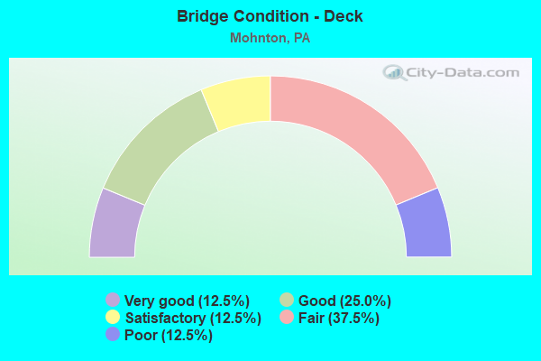
- Bridge Condition - Deck
- 12.5%Very good
- 25.0%Good
- 12.5%Satisfactory
- 37.5%Fair
- 12.5%Poor
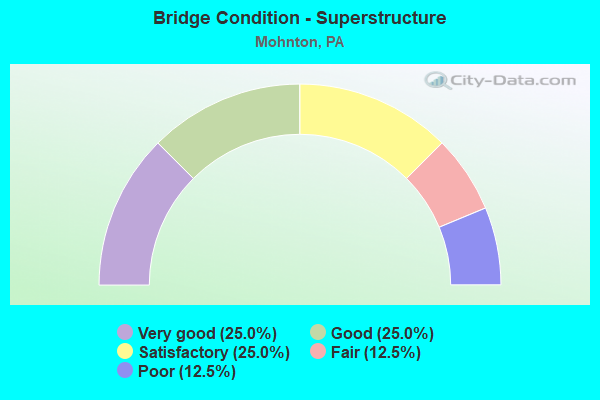
- Bridge Condition - Superstructure
- 25.0%Very good
- 25.0%Good
- 25.0%Satisfactory
- 12.5%Fair
- 12.5%Poor
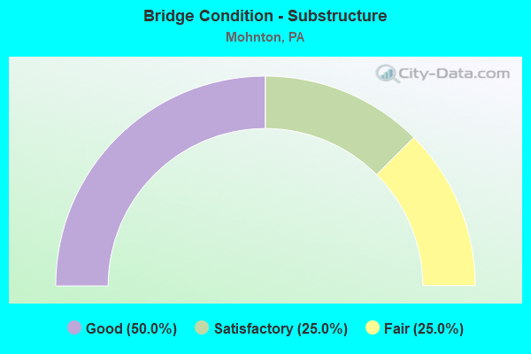
- Bridge Condition - Substructure
- 50.0%Good
- 25.0%Satisfactory
- 25.0%Fair
- Bridge Condition - Channel
- 14.3%Very good
- 14.3%Good
- 57.1%Fair
- 14.3%Poor
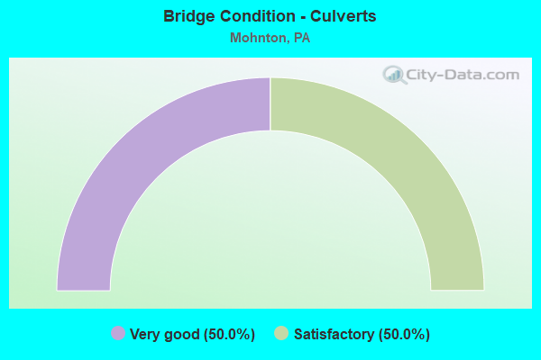
- Bridge Condition - Culverts
- 50.0%Very good
- 50.0%Satisfactory
Find on map >> Show street view
Structure Number: 5146, Location: WYOMISSING ROAD (Lat: 40.279214, Lng: -75.993639), Route carried "on" structure: State highway , Year Built: 1925, Status: Open, Structure Length: 0.85m (2.79ft), Average Daily Traffic: 1,197 (year 2020), Truck Traffic: 5%, Average Future Daily Traffic: 6,436 (year 2032), Design Load: HS 20, Features Intersected: WYOMISSING CREEK, Facility Carried by Structure: SR 3009 (LR 660)
Minimum Vertical Clearance: 30+ m (98+ ft), Kilometerpoint: 4.085, Lanes on structure: 2, Owner: State Highway Agency, Approaching Roadway Width: 6.7m (22.0ft), Skew: 4 degrees, Material/Design: Concrete continuous, Design/Construction: Stringer/Multi-beam, Number Of Spans In Main Unit: 1, Length of Maximum Span: 7.9m (25.9ft), Curb-To-Curb Width: 5.5m (18.0ft), Out-to-Out Width: 6.1m (20.0ft)
Condition: Deck: Fair, Superstructure: Satisfactory, Substructure: Satisfactory, Channel: Fair, Operating Rating: 75.3 metric tons, Method Used To Determine Operating Rating: Load Factor (LF), Inventory Rating: 44.5 metric tons, Method Used To Determine Inventory Rating: Load Factor (LF), Structural Evaluation: Equal to present minimum criteria, Deck Geometry: High priority of replacement, Waterway Adequacy: Equal to present desirable criteria, Approach Roadway Alignment: Somewhat better than minimum adequacy, Length Of Structure Improvement: 1.50m (4.92ft), Designated Inspection Frequency: Every 24 months, Inspection Date: June 2020, Bridge Improvement Cost: $2,000, Roadway Improvement Cost: $6,000, Total Project Cost: $28,000, Deck Structure Type: Concrete Cast-file-Place, Wearing Surface/Protective System: Wearing Surface: Bituminous
Find on map >> Show street view
Structure Number: 5148, Location: MOHNTON BORO (Lat: 40.283217, Lng: -75.988142), Route carried "on" structure: State highway , Year Built: 1966, Year Reconstructed: 2017, Status: Open, Structure Length: 1.86m (6.10ft), Average Daily Traffic: 1,197 (year 2020), Truck Traffic: 5%, Average Future Daily Traffic: 6,436 (year 2036), Design Load: HS 20, Features Intersected: WYOMISSING CREEK, Facility Carried by Structure: SR 3009 (LR 660)
Minimum Vertical Clearance: 30+ m (98+ ft), Kilometerpoint: 4.653, Lanes on structure: 2, Owner: State Highway Agency, Approaching Roadway Width: 10.1m (33.1ft), Skew: 4 degrees, Material/Design: Prestressed concrete, Design/Construction: Box Beam or Girders - Multiple, Number Of Spans In Main Unit: 1, Length of Maximum Span: 18.3m (60.0ft), Curb or Sidewalk Widths: Left: 1.5m (4.9ft), Right: 1.5m (4.9ft), Curb-To-Curb Width: 10.1m (33.1ft), Out-to-Out Width: 13.9m (45.6ft)
Condition: Deck: Very good, Superstructure: Satisfactory, Substructure: Satisfactory, Channel: Fair, Operating Rating: 82.6 metric tons, Method Used To Determine Operating Rating: Assigned rating based on Load Factor Design (LFD) reported in metric tons, Inventory Rating: 45.4 metric tons, Method Used To Determine Inventory Rating: Assigned rating based on Load Factor Design (LFD) reported in metric tons, Structural Evaluation: Equal to present minimum criteria, Deck Geometry: Somewhat better than minimum adequacy, Waterway Adequacy: Equal to present desirable criteria, Approach Roadway Alignment: Equal to present desirable criteria, Length Of Structure Improvement: 2.50m (8.20ft), Designated Inspection Frequency: Every 48 months, Inspection Date: June 2020, Deck Structure Type: Concrete Cast-file-Place, Wearing Surface/Protective System: Wearing Surface: Monolithic Concrete, Deck Protection: Epoxy Coated Reinforcing
Find on map >> Show street view
Structure Number: 5164, Location: MOHNTON BORO(CHURCH ST) (Lat: 40.283842, Lng: -75.981931), Route carried "on" structure: State highway , Year Built: 1949, Status: Open, Structure Length: 1.55m (5.09ft), Average Daily Traffic: 1,275 (year 2022), Truck Traffic: 5%, Average Future Daily Traffic: 1,981 (year 2032), Design Load: HS 20, Features Intersected: WYOMISSING CREEK, Facility Carried by Structure: SR 3022--CHURCH ST
Minimum Vertical Clearance: 30+ m (98+ ft), Kilometerpoint: 0.000, Lanes on structure: 2, Owner: State Highway Agency, Approaching Roadway Width: 7.3m (24.0ft), Skew: 3 degrees, Material/Design: Steel, Design/Construction: Stringer/Multi-beam, Number Of Spans In Main Unit: 1, Length of Maximum Span: 14.6m (47.9ft), Curb or Sidewalk Widths: Left: 1.8m (5.9ft), Right: 1.8m (5.9ft), Curb-To-Curb Width: 7.3m (24.0ft), Out-to-Out Width: 11.6m (38.1ft)
Condition: Deck: Fair, Superstructure: Fair, Substructure: Fair, Channel: Poor, Operating Rating: 71.7 metric tons, Method Used To Determine Operating Rating: Load Factor (LF), Inventory Rating: 42.6 metric tons, Method Used To Determine Inventory Rating: Load Factor (LF), Structural Evaluation: Somewhat better than minimum adequacy, Deck Geometry: Meets minimum limits, Waterway Adequacy: Equal to present desirable criteria, Approach Roadway Alignment: Equal to present desirable criteria, Length Of Structure Improvement: 2.20m (7.22ft), Designated Inspection Frequency: Every 24 months, Inspection Date: October 2019, Bridge Improvement Cost: $6,000, Roadway Improvement Cost: $17,000, Total Project Cost: $79,000, Deck Structure Type: Open Grating
Find on map >> Show street view
Structure Number: 5309, Location: MOHNTON/PENNWYN (Lat: 40.289167, Lng: -75.977397), Route carried "on" structure: City street , Year Built: 1965, Status: Posted for load, Structure Length: 1.19m (3.90ft), Average Daily Traffic: 431 (year 1985), Truck Traffic: 1%, Average Future Daily Traffic: 1,000 (year 2030), Features Intersected: WYOMISSING CREEK, Facility Carried by Structure: WERNER STREET
Minimum Vertical Clearance: 30+ m (98+ ft), Kilometerpoint: 0.000, Lanes on structure: 2, Owner: Town or Township Highway Agency, Approaching Roadway Width: 11.6m (38.1ft), Skew: 1 degrees, Material/Design: Prestressed concrete, Design/Construction: Box Beam or Girders - Multiple, Number Of Spans In Main Unit: 1, Length of Maximum Span: 11.6m (38.1ft), Curb or Sidewalk Widths: Left: 1.6m (5.2ft), Right: 1.6m (5.2ft), Curb-To-Curb Width: 12.2m (40.0ft), Out-to-Out Width: 16.2m (53.1ft)
Condition: Deck: Poor, Superstructure: Poor, Substructure: Fair, Channel: Fair, Operating Rating: 43.5 metric tons, Method Used To Determine Operating Rating: Load Factor (LF), Inventory Rating: 10.9 metric tons, Method Used To Determine Inventory Rating: Load Factor (LF), Structural Evaluation: Meets minimum limits, Deck Geometry: Equal to present desirable criteria, Waterway Adequacy: Better than present minimum criteria, Approach Roadway Alignment: Equal to present desirable criteria, Bridge Posting: Required (Relationship of Operating Rating to Maximum Legal Load: 10.0 - 19.9% below), Length Of Structure Improvement: 1.80m (5.91ft), Designated Inspection Frequency: Every 24 months, Other Special Inspection Frequency: Every 12 months, Inspection Date: December 2020, Other Special Inspection Date: December 2020, Deck Structure Type: Other, Wearing Surface/Protective System: Wearing Surface: Bituminous, Membrane: Built-up
Find on map >> Show street view
Structure Number: 5497, Location: SE MOHNTON (Lat: 40.285658, Lng: -75.980933), Route carried "on" structure: Business City street , Year Built: 1981, Status: Open, Structure Length: 1.01m (3.31ft), Average Daily Traffic: 1,200 (year 2012), Truck Traffic: 1%, Average Future Daily Traffic: 1,500 (year 2024), Design Load: HS 20, Features Intersected: WYOMISSING CREEK, Facility Carried by Structure: MAIN STREET
Minimum Vertical Clearance: 30+ m (98+ ft), Kilometerpoint: 0.000, Lanes on structure: 2, Owner: City or Municipal Highway Agency, Approaching Roadway Width: 7.3m (24.0ft), Material/Design: Prestressed concrete, Design/Construction: Box Beam or Girders - Multiple, Number Of Spans In Main Unit: 1, Length of Maximum Span: 9.8m (32.2ft), Curb or Sidewalk Widths: Left: 1.8m (5.9ft), Right: 1.8m (5.9ft), Curb-To-Curb Width: 7.3m (24.0ft), Out-to-Out Width: 11.6m (38.1ft)
Condition: Deck: Fair, Superstructure: Good, Substructure: Good, Channel: Fair, Operating Rating: 86.2 metric tons, Method Used To Determine Operating Rating: Load Factor (LF), Inventory Rating: 48.1 metric tons, Method Used To Determine Inventory Rating: Load Factor (LF), Structural Evaluation: Better than present minimum criteria, Deck Geometry: Meets minimum limits, Waterway Adequacy: Equal to present desirable criteria, Approach Roadway Alignment: Equal to present desirable criteria, Length Of Structure Improvement: 1.70m (5.58ft), Designated Inspection Frequency: Every 24 months, Inspection Date: September 2021, Deck Structure Type: Concrete Cast-file-Place, Wearing Surface/Protective System: Wearing Surface: Monolithic Concrete
Find on map >> Show street view
Structure Number: 42431, Location: 0.1MI.N.0F SR 222 (Lat: 40.293108, Lng: -76.009347), Route carried "on" structure: State highway , Year Built: 2004, Status: Open, Structure Length: 0.79m (2.59ft), Average Daily Traffic: 1,060 (year 2020), Truck Traffic: 3%, Average Future Daily Traffic: 1,599 (year 2032), Design Load: HS 25 or greater, Features Intersected: KLINES CREEK, Facility Carried by Structure: SR 3020
Minimum Vertical Clearance: 30+ m (98+ ft), Kilometerpoint: 0.000, Lanes on structure: 2, Owner: State Highway Agency, Approaching Roadway Width: 17.1m (56.1ft), Material/Design: Concrete, Design/Construction: Culvert, Number Of Spans In Main Unit: 2, Length of Maximum Span: 3.7m (12.1ft)
Condition: Channel: Very good, Culverts: Satisfactory, Inventory Rating: 90.7 metric tons, Method Used To Determine Inventory Rating: Field evaluation and documented engineering judgment, Structural Evaluation: Equal to present minimum criteria, Waterway Adequacy: Superior to present desirable criteria, Approach Roadway Alignment: Equal to present desirable criteria, Designated Inspection Frequency: Every 48 months, Inspection Date: August 2018
Find on map >> Show street view
Structure Number: 42435, Location: 222 OVER BUS 222 SB RAMP (Lat: 40.297692, Lng: -75.999806), Route carried "on" structure: US 222, Year Built: 2004, Status: Open, Structure Length: 3.23m (10.60ft), Average Daily Traffic: 39,620 (year 2020), Truck Traffic: 16%, Average Future Daily Traffic: 39,920 (year 2032), Design Load: HS 25 or greater, Features Intersected: BUS 222 SB
Minimum Vertical Clearance: 30+ m (98+ ft), Kilometerpoint: 7.139, Lanes on structure: 4, Lanes under structure: 2, Base Highway Network: Yes, Owner: State Highway Agency, Approaching Roadway Width: 27.1m (88.9ft), Skew: 33 degrees, Material/Design: Prestressed concrete, Design/Construction: Box Beam or Girders - Single/Spread, Number Of Spans In Main Unit: 1, Length of Maximum Span: 31.7m (104.0ft), Curb-To-Curb Width: 26.8m (87.9ft), Out-to-Out Width: 28.5m (93.5ft)
Condition: Deck: Satisfactory, Superstructure: Very good, Substructure: Good, Operating Rating: 89.8 metric tons, Method Used To Determine Operating Rating: Load Factor (LF), Inventory Rating: 40.8 metric tons, Method Used To Determine Inventory Rating: Load Factor (LF), Structural Evaluation: Better than present minimum criteria, Deck Geometry: Superior to present desirable criteria, Underclear: Superior to present desirable criteria, Approach Roadway Alignment: Equal to present desirable criteria, Designated Inspection Frequency: Every 48 months, Inspection Date: October 2018, Deck Structure Type: Concrete Cast-file-Place, Wearing Surface/Protective System: Wearing Surface: Monolithic Concrete, Deck Protection: Epoxy Coated Reinforcing
Find on map >> Show street view
Structure Number: 42443, Location: GRINGS HILL OVER SR222 (Lat: 40.292386, Lng: -76.008547), Route carried "on" structure: Ramp State highway , Year Built: 2004, Status: Open, Structure Length: 3.72m (12.20ft), Average Daily Traffic: 1,060 (year 2020), Truck Traffic: 3%, Average Future Daily Traffic: 1,599 (year 2032), Design Load: HS 25 or greater, Features Intersected: US 222, Facility Carried by Structure: SR3020 GRINGS HILL
Minimum Vertical Clearance: 30+ m (98+ ft), Kilometerpoint: 0.000, Lanes on structure: 2, Lanes under structure: 10, Owner: State Highway Agency, Approaching Roadway Width: 13.4m (44.0ft), Material/Design: Prestressed concrete, Design/Construction: Stringer/Multi-beam, Number Of Spans In Main Unit: 1, Length of Maximum Span: 36.6m (120.1ft), Curb-To-Curb Width: 13.4m (44.0ft), Out-to-Out Width: 14.3m (46.9ft)
Condition: Deck: Good, Superstructure: Very good, Substructure: Good, Operating Rating: 88.0 metric tons, Method Used To Determine Operating Rating: Load Factor (LF), Inventory Rating: 40.8 metric tons, Method Used To Determine Inventory Rating: Load Factor (LF), Structural Evaluation: Better than present minimum criteria, Deck Geometry: Superior to present desirable criteria, Underclear: Equal to present desirable criteria, Approach Roadway Alignment: Equal to present desirable criteria, Designated Inspection Frequency: Every 48 months, Inspection Date: March 2019, Deck Structure Type: Concrete Cast-file-Place, Wearing Surface/Protective System: Wearing Surface: Monolithic Concrete, Deck Protection: Epoxy Coated Reinforcing
Find on map >> Show street view
Structure Number: 42444, Location: OLD LANCASTER PIKE (Lat: 40.294089, Lng: -76.005322), Route carried "on" structure: State highway , Year Built: 2004, Status: Open, Structure Length: 5.30m (17.39ft), Average Daily Traffic: 1,060 (year 2020), Truck Traffic: 3%, Average Future Daily Traffic: 1,599 (year 2032), Design Load: HS 25 or greater, Features Intersected: US 222, Facility Carried by Structure: SR3020 OLD LANC.PK
Minimum Vertical Clearance: 30+ m (98+ ft), Kilometerpoint: 0.605, Lanes on structure: 2, Lanes under structure: 8, Owner: State Highway Agency, Approaching Roadway Width: 12.2m (40.0ft), Skew: 2 degrees, Material/Design: Steel, Design/Construction: Stringer/Multi-beam, Number Of Spans In Main Unit: 1, Length of Maximum Span: 51.5m (169.0ft), Curb-To-Curb Width: 12.2m (40.0ft), Out-to-Out Width: 15.8m (51.8ft)
Condition: Deck: Good, Superstructure: Good, Substructure: Good, Operating Rating: 88.0 metric tons, Method Used To Determine Operating Rating: Load Factor (LF), Inventory Rating: 52.6 metric tons, Method Used To Determine Inventory Rating: Load Factor (LF), Structural Evaluation: Better than present minimum criteria, Deck Geometry: Better than present minimum criteria, Underclear: Superior to present desirable criteria, Approach Roadway Alignment: Better than present minimum criteria, Designated Inspection Frequency: Every 48 months, Inspection Date: November 2018, Deck Structure Type: Concrete Cast-file-Place, Wearing Surface/Protective System: Wearing Surface: Monolithic Concrete, Deck Protection: Epoxy Coated Reinforcing
Find on map >> Show street view
Structure Number: 54095, Location: W.WYOMISSING AVE. (Lat: 40.283000, Lng: -75.991528), Route carried "on" structure: State highway , Year Built: 2018, Status: Open, Structure Length: 1.22m (4.00ft), Average Daily Traffic: 1,197 (year 2020), Truck Traffic: 5%, Average Future Daily Traffic: 6,436 (year 2032), Design Load: HL 93, Features Intersected: WYOMISSING CREEK, Facility Carried by Structure: W.WYOMISSING AVE.
Minimum Vertical Clearance: 30+ m (98+ ft), Kilometerpoint: 4.085, Lanes on structure: 2, Owner: State Highway Agency, Maintenance Responsibility: Private, Approaching Roadway Width: 9.1m (29.9ft), Skew: 4 degrees, Material/Design: Concrete, Design/Construction: Culvert, Number Of Spans In Main Unit: 1, Length of Maximum Span: 11.3m (37.1ft), Curb-To-Curb Width: 9.1m (29.9ft), Out-to-Out Width: 22.6m (74.1ft)
Condition: Channel: Good, Culverts: Very good, Operating Rating: 52.2 metric tons, Method Used To Determine Operating Rating: Assigned ratings based on Load and Resistance Factor Design (LRFD) reported by rating factor (RF) using HL93 loadings, Inventory Rating: 32.7 metric tons, Method Used To Determine Inventory Rating: Assigned ratings based on Load and Resistance Factor Design (LRFD) reported by rating factor (RF) using HL93 loadings, Structural Evaluation: Equal to present desirable criteria, Deck Geometry: Somewhat better than minimum adequacy, Waterway Adequacy: Better than present minimum criteria, Approach Roadway Alignment: Equal to present desirable criteria, Designated Inspection Frequency: Every 24 months, Inspection Date: April 2020, Wearing Surface/Protective System: Wearing Surface: Bituminous, Membrane: Preformed Fabric, Deck Protection: Epoxy Coated Reinforcing
Find on map >> Show street view
Structure Number: 42435, Location: 222 OVER BUS 222 SB RAMP (Lat: 40.297692, Lng: -75.999806), Route carried "under" structure: Business US 222B, Year Built: 2004, Structure Length: 0. m, Average Daily Traffic: 4,014 (year 2022), Truck Traffic: 4%, Features Intersected: BUS 222 SB, Facility Carried by Structure: US 222
Minimum Vertical Clearance: 5.24m (17.19ft), Kilometerpoint: 0.000, Lanes on structure: 4, Lanes under structure: 2, Material/Design: Prestressed concrete, Design/Construction: Box Beam or Girders - Single/Spread, Length of Maximum Span: 31.7m (104.0ft)
Find on map >> Show street view
Structure Number: 42443, Location: GRINGS HILL OVER SR222 (Lat: 40.292386, Lng: -76.008547), Route carried "under" structure: US 222, Year Built: 2004, Structure Length: 0. m, Average Daily Traffic: 19,730 (year 2020), Truck Traffic: 15%, Features Intersected: US 222, Facility Carried by Structure: SR3020 GRINGS HILL
Minimum Vertical Clearance: 6.47m (21.23ft), Kilometerpoint: 6.193, Lanes on structure: 2, Lanes under structure: 5, Material/Design: Prestressed concrete, Design/Construction: Stringer/Multi-beam, Length of Maximum Span: 36.6m (120.1ft)
Find on map >> Show street view
Structure Number: 42443, Location: GRINGS HILL OVER SR222 (Lat: 40.292386, Lng: -76.008547), Route carried "under" structure: US 222, Year Built: 2004, Structure Length: 0. m, Average Daily Traffic: 19,890 (year 2020), Truck Traffic: 16%, Features Intersected: US 222, Facility Carried by Structure: SR3020 GRINGS HILL
Minimum Vertical Clearance: 5.82m (19.09ft), Kilometerpoint: 6.198, Lanes on structure: 2, Lanes under structure: 5, Material/Design: Prestressed concrete, Design/Construction: Stringer/Multi-beam, Length of Maximum Span: 36.6m (120.1ft)
Find on map >> Show street view
Structure Number: 42444, Location: OLD LANCASTER PIKE (Lat: 40.294089, Lng: -76.005322), Route carried "under" structure: US 222, Year Built: 2004, Structure Length: 0. m, Average Daily Traffic: 19,890 (year 2020), Truck Traffic: 16%, Features Intersected: US 222, Facility Carried by Structure: SR3020 OLD LANC.PK
Minimum Vertical Clearance: 6.22m (20.41ft), Kilometerpoint: 6.198, Lanes on structure: 2, Lanes under structure: 2, Material/Design: Steel, Design/Construction: Stringer/Multi-beam, Length of Maximum Span: 51.5m (169.0ft)
Find on map >> Show street view
Structure Number: 42444, Location: OLD LANCASTER PIKE (Lat: 40.294089, Lng: -76.005322), Route carried "under" structure: Ramp State highway , Year Built: 2004, Structure Length: 0. m, Average Daily Traffic: 3,288 (year 2022), Truck Traffic: 7%, Features Intersected: US 222, Facility Carried by Structure: SR3020 OLD LANC.PK
Minimum Vertical Clearance: 7.25m (23.79ft), Kilometerpoint: 0.000, Lanes on structure: 2, Lanes under structure: 2, Material/Design: Steel, Design/Construction: Stringer/Multi-beam, Length of Maximum Span: 51.5m (169.0ft)
Find on map >> Show street view
Structure Number: 42444, Location: OLD LANCASTER PIKE (Lat: 40.294089, Lng: -76.005322), Route carried "under" structure: US 222B, Year Built: 2004, Structure Length: 0. m, Average Daily Traffic: 4,014 (year 2022), Truck Traffic: 4%, Features Intersected: US 222, Facility Carried by Structure: SR3020 OLD LANC.PK
Minimum Vertical Clearance: 6.95m (22.80ft), Kilometerpoint: 0.000, Lanes on structure: 2, Lanes under structure: 1, Material/Design: Steel, Design/Construction: Stringer/Multi-beam, Length of Maximum Span: 51.5m (169.0ft)
Find on map >> Show street view
Structure Number: 42444, Location: OLD LANCASTER PIKE (Lat: 40.294089, Lng: -76.005322), Route carried "under" structure: US 222, Year Built: 2004, Structure Length: 0. m, Average Daily Traffic: 19,730 (year 2020), Truck Traffic: 15%, Features Intersected: US 222, Facility Carried by Structure: SR3020 OLD LANC.PK
Minimum Vertical Clearance: 5.79m (19.00ft), Kilometerpoint: 6.193, Lanes on structure: 2, Lanes under structure: 3, Material/Design: Steel, Design/Construction: Stringer/Multi-beam, Length of Maximum Span: 51.5m (169.0ft)