Bridge Statistics for Montezuma, Georgia (GA)
Condition, Traffic, Stress, Structural Evaluation, Project Costs
- National Bridge Inventory (NBI) Statistics
- 18Number of bridges
- 554ft / 169mTotal length
- $113,153,000Total costs
- 61,460Total average daily traffic
- 4,480Total average daily truck traffic
- 92,190Total future (year 2031) average daily traffic
- National Bridge Inventory (NBI) Registered Bridges for Montezuma
- No street view available for this location
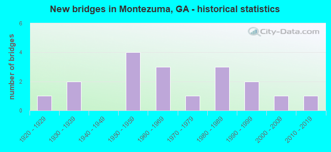
- New bridges - historical statistics
- 11920-1929
- 21930-1939
- 41950-1959
- 31960-1969
- 11970-1979
- 31980-1989
- 21990-1999
- 12000-2009
- 12010-2019
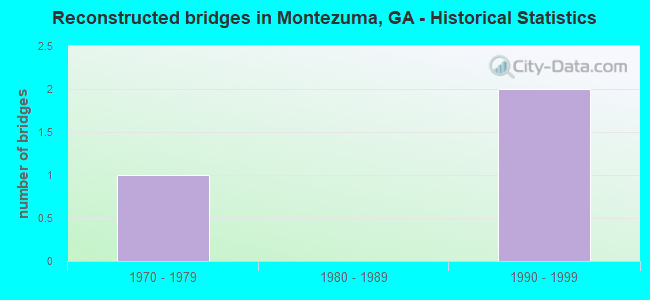
- Reconstructed bridges - Historical Statistics
- 11970-1979
- 01980-1989
- 21990-1999
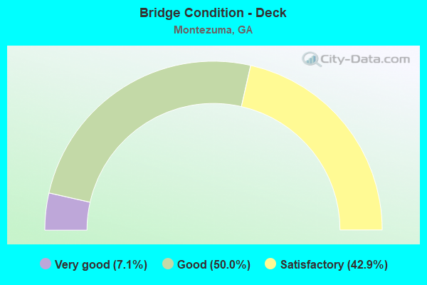
- Bridge Condition - Deck
- 7.1%Very good
- 50.0%Good
- 42.9%Satisfactory
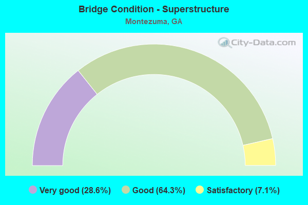
- Bridge Condition - Superstructure
- 28.6%Very good
- 64.3%Good
- 7.1%Satisfactory
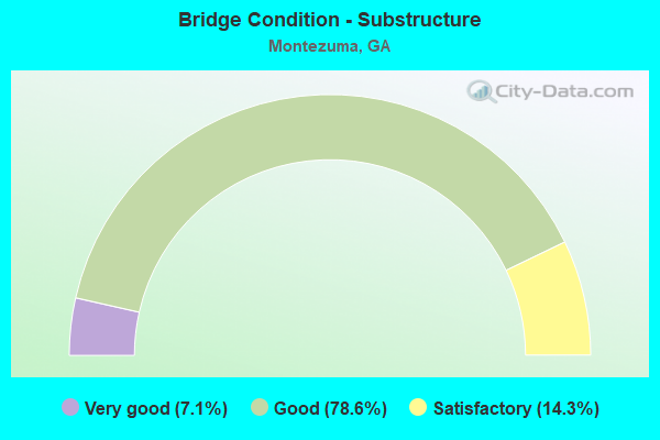
- Bridge Condition - Substructure
- 7.1%Very good
- 78.6%Good
- 14.3%Satisfactory
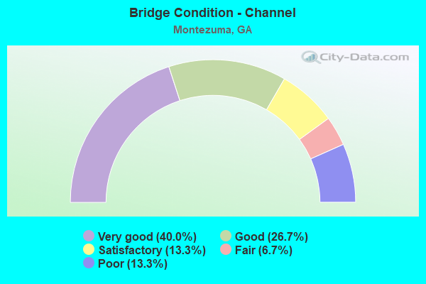
- Bridge Condition - Channel
- 40.0%Very good
- 26.7%Good
- 13.3%Satisfactory
- 6.7%Fair
- 13.3%Poor
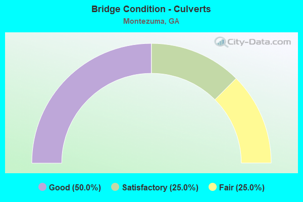
- Bridge Condition - Culverts
- 50.0%Good
- 25.0%Satisfactory
- 25.0%Fair
Find on map >> Show street view
Structure Number: 1930001, Location: CITY LIMITS OF OGLETHORPE (Lat: 32.273697, Lng: -84.069597), Route carried "on" structure: State highway 26, Year Built: 1982, Status: Open, Structure Length: 5.85m (19.19ft), Average Daily Traffic: 4,070 (year 2011), Truck Traffic: 1%, Average Future Daily Traffic: 6,105 (year 2031), Design Load: HS 20+Mod, Features Intersected: CSX RAILROAD
Minimum Vertical Clearance: 30+ m (98+ ft), Kilometerpoint: 16.093, Lanes on structure: 2, Base Highway Network: Yes, Owner: State Highway Agency, Approaching Roadway Width: 8.5m (27.9ft), Skew: 3 degrees, Material/Design: Prestressed concrete, Design/Construction: Stringer/Multi-beam, Number Of Spans In Main Unit: 3, Length of Maximum Span: 19.5m (64.0ft), Curb-To-Curb Width: 12.2m (40.0ft), Out-to-Out Width: 13.2m (43.3ft)
Condition: Deck: Satisfactory, Superstructure: Very good, Substructure: Good, Operating Rating: 64.4 metric tons, Method Used To Determine Operating Rating: Load Factor (LF), Inventory Rating: 37.1 metric tons, Method Used To Determine Inventory Rating: Load Factor (LF), Structural Evaluation: Better than present minimum criteria, Deck Geometry: Equal to present minimum criteria, Underclear: Equal to present minimum criteria, Approach Roadway Alignment: Equal to present minimum criteria, Designated Inspection Frequency: Every 24 months, Inspection Date: November 2020, Bridge Improvement Cost: $750,000, Roadway Improvement Cost: $75,000, Total Project Cost: $1,125,000, Deck Structure Type: Concrete Cast-file-Place
Find on map >> Show street view
Structure Number: 1930002, Location: 1 MI W OF MONTEZUMA (Lat: 32.292908, Lng: -84.043508), Route carried "on" structure: State highway 26, Year Built: 1982, Status: Open, Structure Length: 47.73m (156.59ft), Average Daily Traffic: 6,950 (year 2011), Truck Traffic: 17%, Average Future Daily Traffic: 10,425 (year 2031), Design Load: HS 20+Mod, Features Intersected: FLINT RIVER
Minimum Vertical Clearance: 30+ m (98+ ft), Kilometerpoint: 19.312, Lanes on structure: 2, Base Highway Network: Yes, Owner: State Highway Agency, Approaching Roadway Width: 7.9m (25.9ft), Material/Design: Prestressed concrete, Design/Construction: Stringer/Multi-beam, Number Of Spans In Main Unit: 18, Length of Maximum Span: 26.5m (86.9ft), Curb-To-Curb Width: 12.2m (40.0ft), Out-to-Out Width: 13.2m (43.3ft)
Condition: Deck: Good, Superstructure: Good, Substructure: Good, Channel: Very good, Operating Rating: 68.9 metric tons, Method Used To Determine Operating Rating: Load Factor (LF), Inventory Rating: 35.3 metric tons, Method Used To Determine Inventory Rating: Load Factor (LF), Structural Evaluation: Better than present minimum criteria, Deck Geometry: Somewhat better than minimum adequacy, Waterway Adequacy: Equal to present desirable criteria, Approach Roadway Alignment: Equal to present desirable criteria, Designated Inspection Frequency: Every 24 months, Underwater Inspection Frequency: Every 60 months, Inspection Date: December 2020, Underwater Inspection Date: March 2021, Bridge Improvement Cost: $6,119,000, Roadway Improvement Cost: $612,000, Total Project Cost: $9,178,000, Deck Structure Type: Concrete Cast-file-Place
Find on map >> Show street view
Structure Number: 1930003, Location: .5 MI W OF MONTEZUMA (Lat: 32.293197, Lng: -84.036569), Route carried "on" structure: State highway 26, Year Built: 1982, Status: Open, Structure Length: 8.53m (27.99ft), Average Daily Traffic: 6,950 (year 2011), Truck Traffic: 17%, Average Future Daily Traffic: 10,425 (year 2031), Design Load: HS 20+Mod, Features Intersected: FLINT RIVER OVERFLOW
Minimum Vertical Clearance: 30+ m (98+ ft), Kilometerpoint: 19.312, Lanes on structure: 2, Base Highway Network: Yes, Owner: State Highway Agency, Approaching Roadway Width: 7.9m (25.9ft), Material/Design: Prestressed concrete, Design/Construction: Stringer/Multi-beam, Number Of Spans In Main Unit: 7, Length of Maximum Span: 12.2m (40.0ft), Curb-To-Curb Width: 12.2m (40.0ft), Out-to-Out Width: 13.2m (43.3ft)
Condition: Deck: Good, Superstructure: Good, Substructure: Good, Channel: Very good, Operating Rating: 35.3 metric tons, Method Used To Determine Operating Rating: Load Factor (LF), Inventory Rating: 20.8 metric tons, Method Used To Determine Inventory Rating: Load Factor (LF), Structural Evaluation: Somewhat better than minimum adequacy, Deck Geometry: Somewhat better than minimum adequacy, Waterway Adequacy: Equal to present desirable criteria, Approach Roadway Alignment: Equal to present desirable criteria, Designated Inspection Frequency: Every 24 months, Inspection Date: December 2020, Bridge Improvement Cost: $1,094,000, Roadway Improvement Cost: $109,000, Total Project Cost: $1,641,000, Deck Structure Type: Concrete Cast-file-Place
Find on map >> Show street view
Structure Number: 1930005, Location: 1 MI E OF MONTEZUMA (Lat: 32.293189, Lng: -83.990897), Route carried "on" structure: State highway 26, Year Built: 1934, Status: Open, Structure Length: 0.64m (2.10ft), Average Daily Traffic: 2,960 (year 2011), Truck Traffic: 27%, Average Future Daily Traffic: 4,440 (year 2031), Design Load: H 15, Features Intersected: SPRING CREEK
Minimum Vertical Clearance: 30+ m (98+ ft), Kilometerpoint: 24.140, Lanes on structure: 2, Base Highway Network: Yes, Owner: State Highway Agency, Approaching Roadway Width: 8.5m (27.9ft), Material/Design: Concrete, Design/Construction: Culvert, Number Of Spans In Main Unit: 2, Length of Maximum Span: 3.0m (9.8ft)
Condition: Channel: Fair, Culverts: Good, Operating Rating: 55.3 metric tons, Method Used To Determine Operating Rating: Load Factor (LF), Inventory Rating: 32.6 metric tons, Method Used To Determine Inventory Rating: Load Factor (LF), Structural Evaluation: Better than present minimum criteria, Waterway Adequacy: Equal to present minimum criteria, Approach Roadway Alignment: Equal to present desirable criteria, Designated Inspection Frequency: Every 24 months, Underwater Inspection Frequency: Every 60 months, Inspection Date: November 2020, Underwater Inspection Date: March 2021, Bridge Improvement Cost: $82,000, Roadway Improvement Cost: $8,000, Total Project Cost: $123,000
Find on map >> Show street view
Structure Number: 1930011, Location: WEST OGLETHORPE (Lat: 32.291550, Lng: -84.064178), Route carried "on" structure: State highway 49, Year Built: 1927, Status: Open, Structure Length: 0.79m (2.59ft), Average Daily Traffic: 4,150 (year 2011), Truck Traffic: 1%, Average Future Daily Traffic: 6,225 (year 2031), Design Load: H 15, Features Intersected: BUCK CREEK TRIB, Facility Carried by Structure: CHATAM STREET
Minimum Vertical Clearance: 30+ m (98+ ft), Kilometerpoint: 14.484, Lanes on structure: 2, Base Highway Network: Yes, Owner: State Highway Agency, Approaching Roadway Width: 10.4m (34.1ft), Material/Design: Concrete, Design/Construction: Culvert, Number Of Spans In Main Unit: 3, Length of Maximum Span: 2.4m (7.9ft), Curb or Sidewalk Widths: Left: 1.5m (4.9ft), Right: 1.5m (4.9ft)
Condition: Channel: Good, Culverts: Good, Operating Rating: 41.7 metric tons, Method Used To Determine Operating Rating: Field evaluation and documented engineering judgment, Inventory Rating: 24.4 metric tons, Method Used To Determine Inventory Rating: Field evaluation and documented engineering judgment, Structural Evaluation: Equal to present minimum criteria, Waterway Adequacy: Equal to present minimum criteria, Approach Roadway Alignment: Equal to present desirable criteria, Designated Inspection Frequency: Every 24 months, Inspection Date: November 2020, Bridge Improvement Cost: $102,000, Roadway Improvement Cost: $10,000, Total Project Cost: $152,000
Find on map >> Show street view
Structure Number: 1930014, Location: WEST MONTEZUMA (Lat: 32.297667, Lng: -84.044353), Route carried "on" structure: State highway 49, Year Built: 1955, Status: Open, Structure Length: 45.26m (148.49ft), Average Daily Traffic: 5,490 (year 2011), Truck Traffic: 9%, Average Future Daily Traffic: 8,235 (year 2031), Design Load: HS 20, Features Intersected: FLINT RIVER, Facility Carried by Structure: OGLETHORPE RD
Minimum Vertical Clearance: 30+ m (98+ ft), Kilometerpoint: 16.093, Lanes on structure: 2, Base Highway Network: Yes, Owner: State Highway Agency, Approaching Roadway Width: 8.2m (26.9ft), Material/Design: Steel continuous, Design/Construction: Stringer/Multi-beam, Number Of Spans In Main Unit: 20, Length of Maximum Span: 30.5m (100.1ft), Curb or Sidewalk Widths: Left: 0.6m (2.0ft), Right: 0.6m (2.0ft), Curb-To-Curb Width: 8.4m (27.6ft), Out-to-Out Width: 10.4m (34.1ft)
Condition: Deck: Satisfactory, Superstructure: Good, Substructure: Satisfactory, Channel: Poor, Operating Rating: 34.4 metric tons, Method Used To Determine Operating Rating: Load Factor (LF), Inventory Rating: 19.9 metric tons, Method Used To Determine Inventory Rating: Load Factor (LF), Structural Evaluation: Somewhat better than minimum adequacy, Deck Geometry: High priority of corrective action, Waterway Adequacy: Equal to present desirable criteria, Approach Roadway Alignment: Equal to present minimum criteria, Length Of Structure Improvement: 85.47m (280.41ft), Designated Inspection Frequency: Every 24 months, Underwater Inspection Frequency: Every 60 months, Inspection Date: December 2020, Underwater Inspection Date: March 2021, Bridge Improvement Cost: $5,802,000, Roadway Improvement Cost: $580,000, Total Project Cost: $8,703,000, Deck Structure Type: Concrete Cast-file-Place
Find on map >> Show street view
Structure Number: 1930016, Location: 2 MI S E OF MONTEZUMA (Lat: 32.284836, Lng: -84.008861), Route carried "on" structure: State highway 90, Year Built: 1935, Status: Open, Structure Length: 0.64m (2.10ft), Average Daily Traffic: 1,990 (year 2011), Truck Traffic: 1%, Average Future Daily Traffic: 2,985 (year 2031), Design Load: H 15, Features Intersected: SPRING CREEK
Minimum Vertical Clearance: 30+ m (98+ ft), Kilometerpoint: 6.437, Lanes on structure: 2, Base Highway Network: Yes, Owner: State Highway Agency, Approaching Roadway Width: 7.6m (24.9ft), Material/Design: Concrete, Design/Construction: Culvert, Number Of Spans In Main Unit: 2, Length of Maximum Span: 3.0m (9.8ft)
Condition: Channel: Satisfactory, Culverts: Satisfactory, Operating Rating: 41.7 metric tons, Method Used To Determine Operating Rating: Field evaluation and documented engineering judgment, Inventory Rating: 24.4 metric tons, Method Used To Determine Inventory Rating: Field evaluation and documented engineering judgment, Structural Evaluation: Equal to present minimum criteria, Waterway Adequacy: Somewhat better than minimum adequacy, Approach Roadway Alignment: Equal to present desirable criteria, Designated Inspection Frequency: Every 24 months, Underwater Inspection Frequency: Every 60 months, Inspection Date: November 2020, Underwater Inspection Date: March 2021, Bridge Improvement Cost: $82,000, Roadway Improvement Cost: $8,000, Total Project Cost: $123,000
Find on map >> Show street view
Structure Number: 1930017, Location: CITY LIMITS OF MONTEZUMA (Lat: 32.298019, Lng: -84.027214), Route carried "on" structure: County highway 715, Year Built: 1958, Status: Open, Structure Length: 3.66m (12.01ft), Average Daily Traffic: 4,930 (year 2011), Truck Traffic: 1%, Average Future Daily Traffic: 7,395 (year 2031), Design Load: HS 20+Mod, Features Intersected: BEAVER CREEK, Facility Carried by Structure: SPALDING STREET
Minimum Vertical Clearance: 30+ m (98+ ft), Kilometerpoint: 1.609, Lanes on structure: 2, Base Highway Network: Yes, Owner: County Highway Agency, Approaching Roadway Width: 15.8m (51.8ft), Material/Design: Concrete, Design/Construction: Tee Beam, Number Of Spans In Main Unit: 3, Length of Maximum Span: 12.2m (40.0ft), Curb or Sidewalk Widths: Left: 1.5m (4.9ft), Right: 1.5m (4.9ft), Curb-To-Curb Width: 13.4m (44.0ft), Out-to-Out Width: 17.1m (56.1ft)
Condition: Deck: Satisfactory, Superstructure: Good, Substructure: Good, Channel: Very good, Operating Rating: 38.1 metric tons, Method Used To Determine Operating Rating: Load Factor (LF), Inventory Rating: 22.6 metric tons, Method Used To Determine Inventory Rating: Load Factor (LF), Structural Evaluation: Equal to present minimum criteria, Deck Geometry: Better than present minimum criteria, Waterway Adequacy: Equal to present desirable criteria, Approach Roadway Alignment: Equal to present desirable criteria, Designated Inspection Frequency: Every 24 months, Inspection Date: December 2020, Bridge Improvement Cost: $469,000, Roadway Improvement Cost: $47,000, Total Project Cost: $703,000, Deck Structure Type: Concrete Cast-file-Place
Find on map >> Show street view
Structure Number: 1930024, Location: 4 M W OF MARSHALLVILLE (Lat: 32.437422, Lng: -84.020967), Route carried "on" structure: County highway 307, Year Built: 1950, Year Reconstructed: 1977, Status: Posted for load, Structure Length: 1.22m (4.00ft), Average Daily Traffic: 10 (year 2011), Truck Traffic: 1%, Average Future Daily Traffic: 15 (year 2031), Design Load: H 15, Features Intersected: FLINT RIVER OVERFLOW, Facility Carried by Structure: WEST FERRY ROAD
Minimum Vertical Clearance: 30+ m (98+ ft), Kilometerpoint: 3.219, Lanes on structure: 2, Base Highway Network: Yes, Owner: County Highway Agency, Approaching Roadway Width: 4.6m (15.1ft), Material/Design: Steel, Design/Construction: Stringer/Multi-beam, Number Of Spans In Main Unit: 2, Length of Maximum Span: 6.1m (20.0ft), Curb-To-Curb Width: 6.6m (21.7ft), Out-to-Out Width: 6.8m (22.3ft)
Condition: Deck: Satisfactory, Superstructure: Satisfactory, Substructure: Satisfactory, Channel: Good, Operating Rating: 26.3 metric tons, Method Used To Determine Operating Rating: Allowable Stress (AS), Inventory Rating: 19.0 metric tons, Method Used To Determine Inventory Rating: Allowable Stress (AS), Structural Evaluation: Somewhat better than minimum adequacy, Deck Geometry: Somewhat better than minimum adequacy, Waterway Adequacy: High priority of corrective action, Approach Roadway Alignment: High priority of corrective action, Bridge Posting: Required (Relationship of Operating Rating to Maximum Legal Load: 20.0 - 29.9% below), Length Of Structure Improvement: 162.18m (532.09ft), Designated Inspection Frequency: Every 24 months, Inspection Date: November 2020, Bridge Improvement Cost: $156,000, Roadway Improvement Cost: $16,000, Total Project Cost: $234,000, Deck Structure Type: Wood or Timber
Find on map >> Show street view
Structure Number: 1930029, Location: N.E. MONTEZUMA (Lat: 32.314092, Lng: -84.009678), Route carried "on" structure: County highway 305, Year Built: 1964, Status: Posted for load, Structure Length: 2.93m (9.61ft), Average Daily Traffic: 600 (year 2011), Truck Traffic: 1%, Average Future Daily Traffic: 900 (year 2031), Design Load: H 15, Features Intersected: BEAVER CREEK
Minimum Vertical Clearance: 30+ m (98+ ft), Kilometerpoint: 1.609, Lanes on structure: 2, Base Highway Network: Yes, Owner: County Highway Agency, Approaching Roadway Width: 7.0m (23.0ft), Material/Design: Concrete, Design/Construction: Tee Beam, Number Of Spans In Main Unit: 3, Length of Maximum Span: 9.8m (32.2ft), Curb or Sidewalk Widths: Left: 0.6m (2.0ft), Right: 0.6m (2.0ft), Curb-To-Curb Width: 7.9m (25.9ft), Out-to-Out Width: 9.2m (30.2ft)
Condition: Deck: Satisfactory, Superstructure: Good, Substructure: Good, Channel: Poor, Operating Rating: 25.4 metric tons, Method Used To Determine Operating Rating: Load Factor (LF), Inventory Rating: 14.5 metric tons, Method Used To Determine Inventory Rating: Load Factor (LF), Structural Evaluation: Meets minimum limits, Deck Geometry: Somewhat better than minimum adequacy, Waterway Adequacy: Equal to present desirable criteria, Approach Roadway Alignment: Equal to present minimum criteria, Bridge Posting: Required (Relationship of Operating Rating to Maximum Legal Load: 10.0 - 19.9% below), Length Of Structure Improvement: 9.36m (30.71ft), Designated Inspection Frequency: Every 24 months, Inspection Date: December 2020, Bridge Improvement Cost: $375,000, Roadway Improvement Cost: $38,000, Total Project Cost: $563,000, Deck Structure Type: Concrete Cast-file-Place
Find on map >> Show street view
Structure Number: 1930036, Location: MONTEZUMA CITY LIMITS (Lat: 32.285058, Lng: -84.031128), Route carried "on" structure: County highway 533, Year Built: 1967, Year Reconstructed: 2002, Status: Open, Structure Length: 0.64m (2.10ft), Average Daily Traffic: 1,350 (year 2011), Truck Traffic: 1%, Average Future Daily Traffic: 2,025 (year 2031), Design Load: H 15, Features Intersected: SPRING CREEK, Facility Carried by Structure: DRAYTON ROAD
Minimum Vertical Clearance: 30+ m (98+ ft), Kilometerpoint: 8.047, Lanes on structure: 2, Base Highway Network: Yes, Owner: City or Municipal Highway Agency, Approaching Roadway Width: 7.9m (25.9ft), Material/Design: Concrete, Design/Construction: Culvert, Number Of Spans In Main Unit: 2, Length of Maximum Span: 3.0m (9.8ft), Curb or Sidewalk Widths: Left: 0.0m, Right: 1.5m (4.9ft)
Condition: Channel: Good, Culverts: Fair, Operating Rating: 41.7 metric tons, Method Used To Determine Operating Rating: Field evaluation and documented engineering judgment, Inventory Rating: 24.4 metric tons, Method Used To Determine Inventory Rating: Field evaluation and documented engineering judgment, Structural Evaluation: Somewhat better than minimum adequacy, Waterway Adequacy: Equal to present minimum criteria, Approach Roadway Alignment: Equal to present minimum criteria, Designated Inspection Frequency: Every 24 months, Underwater Inspection Frequency: Every 60 months, Inspection Date: November 2020, Underwater Inspection Date: March 2021, Bridge Improvement Cost: $82,000, Roadway Improvement Cost: $8,000, Total Project Cost: $123,000
Find on map >> Show street view
Structure Number: 193005, Location: 6 MI SW OF OGLETHORPE (Lat: 32.221539, Lng: -84.101369), Route carried "on" structure: State highway 49, Year Built: 1990, Status: Open, Structure Length: 6.92m (22.70ft), Average Daily Traffic: 4,740 (year 2011), Truck Traffic: 1%, Average Future Daily Traffic: 7,110 (year 2031), Design Load: HS 20+Mod, Features Intersected: NS RAILROAD
Minimum Vertical Clearance: 30+ m (98+ ft), Kilometerpoint: 6.437, Lanes on structure: 2, Base Highway Network: Yes, Owner: State Highway Agency, Approaching Roadway Width: 8.5m (27.9ft), Skew: 4 degrees, Material/Design: Prestressed concrete, Design/Construction: Stringer/Multi-beam, Number Of Spans In Main Unit: 4, Length of Maximum Span: 23.8m (78.1ft), Curb-To-Curb Width: 13.4m (44.0ft), Out-to-Out Width: 14.4m (47.2ft)
Condition: Deck: Good, Superstructure: Very good, Substructure: Good, Operating Rating: 49.8 metric tons, Method Used To Determine Operating Rating: Load Factor (LF), Inventory Rating: 26.3 metric tons, Method Used To Determine Inventory Rating: Load Factor (LF), Structural Evaluation: Equal to present minimum criteria, Deck Geometry: Better than present minimum criteria, Underclear: Superior to present desirable criteria, Approach Roadway Alignment: Equal to present minimum criteria, Designated Inspection Frequency: Every 24 months, Inspection Date: November 2020, Bridge Improvement Cost: $887,000, Roadway Improvement Cost: $89,000, Total Project Cost: $1,330,000, Deck Structure Type: Concrete Cast-file-Place
Find on map >> Show street view
Structure Number: 1930051, Location: CENTRAL MONTEZUMA (Lat: 32.293419, Lng: -84.010158), Route carried "on" structure: State highway 26, Year Built: 1991, Status: Open, Structure Length: 5.27m (17.29ft), Average Daily Traffic: 6,660 (year 2011), Truck Traffic: 1%, Average Future Daily Traffic: 9,990 (year 2031), Design Load: HS 20+Mod, Features Intersected: CSX RAILROAD
Minimum Vertical Clearance: 30+ m (98+ ft), Kilometerpoint: 22.531, Lanes on structure: 2, Base Highway Network: Yes, Owner: State Highway Agency, Approaching Roadway Width: 8.5m (27.9ft), Skew: 3 degrees, Material/Design: Prestressed concrete, Design/Construction: Stringer/Multi-beam, Number Of Spans In Main Unit: 3, Length of Maximum Span: 21.0m (68.9ft), Curb-To-Curb Width: 13.5m (44.3ft), Out-to-Out Width: 14.5m (47.6ft)
Condition: Deck: Good, Superstructure: Very good, Substructure: Good, Operating Rating: 55.3 metric tons, Method Used To Determine Operating Rating: Load Factor (LF), Inventory Rating: 26.3 metric tons, Method Used To Determine Inventory Rating: Load Factor (LF), Structural Evaluation: Equal to present minimum criteria, Deck Geometry: Superior to present desirable criteria, Underclear: Superior to present desirable criteria, Approach Roadway Alignment: Equal to present desirable criteria, Designated Inspection Frequency: Every 24 months, Inspection Date: November 2020, Bridge Improvement Cost: $676,000, Roadway Improvement Cost: $68,000, Total Project Cost: $1,014,000, Deck Structure Type: Concrete Cast-file-Place
Find on map >> Show street view
Structure Number: 1935035, Location: CITY LIMITS MONTEZUMA (Lat: 32.308178, Lng: -84.014778), Route carried "on" structure: County highway 197, Year Built: 1960, Status: Posted for load, Structure Length: 2.93m (9.61ft), Average Daily Traffic: 600 (year 2011), Truck Traffic: 1%, Average Future Daily Traffic: 900 (year 2031), Design Load: H 15, Features Intersected: BEAVER CREEK, Facility Carried by Structure: HAMILTON ROAD
Minimum Vertical Clearance: 30+ m (98+ ft), Kilometerpoint: 1.609, Lanes on structure: 2, Base Highway Network: Yes, Owner: County Highway Agency, Approaching Roadway Width: 7.3m (24.0ft), Material/Design: Concrete, Design/Construction: Slab, Number Of Spans In Main Unit: 6, Length of Maximum Span: 4.9m (16.1ft), Curb or Sidewalk Widths: Left: 0.2m (0.7ft), Right: 0.2m (0.7ft), Curb-To-Curb Width: 7.3m (24.0ft), Out-to-Out Width: 7.6m (24.9ft)
Condition: Deck: Good, Superstructure: Good, Substructure: Good, Channel: Good, Operating Rating: 12.7 metric tons, Method Used To Determine Operating Rating: Load Factor (LF), Inventory Rating: 8.1 metric tons, Method Used To Determine Inventory Rating: Load Factor (LF), Structural Evaluation: High priority of corrective action, Deck Geometry: Meets minimum limits, Waterway Adequacy: Better than present minimum criteria, Approach Roadway Alignment: Better than present minimum criteria, Bridge Posting: Required (Relationship of Operating Rating to Maximum Legal Load: > 39.9% below), Length Of Structure Improvement: 9.36m (30.71ft), Designated Inspection Frequency: Every 24 months, Inspection Date: December 2020, Bridge Improvement Cost: $375,000, Roadway Improvement Cost: $38,000, Total Project Cost: $563,000, Deck Structure Type: Concrete Precast Panels
Find on map >> Show street view
Structure Number: 193504, Location: 3 MI N OF MONTEZUMA (Lat: 32.366289, Lng: -83.994569), Route carried "on" structure: County highway 283, Year Built: 1973, Year Reconstructed: 2002, Status: Open, Structure Length: 3.66m (12.01ft), Average Daily Traffic: 110 (year 2011), Truck Traffic: 1%, Average Future Daily Traffic: 165 (year 2031), Design Load: H 15, Features Intersected: BEAVER CREEK, Facility Carried by Structure: BARRONS LANE RD.
Minimum Vertical Clearance: 30+ m (98+ ft), Kilometerpoint: 1.609, Lanes on structure: 2, Base Highway Network: Yes, Owner: County Highway Agency, Approaching Roadway Width: 7.9m (25.9ft), Material/Design: Prestressed concrete, Design/Construction: Channel Beam, Number Of Spans In Main Unit: 6, Length of Maximum Span: 6.1m (20.0ft), Curb-To-Curb Width: 7.1m (23.3ft), Out-to-Out Width: 8.0m (26.2ft)
Condition: Deck: Good, Superstructure: Good, Substructure: Good, Channel: Satisfactory, Operating Rating: 44.4 metric tons, Method Used To Determine Operating Rating: Load Factor (LF), Inventory Rating: 26.3 metric tons, Method Used To Determine Inventory Rating: Load Factor (LF), Structural Evaluation: Equal to present minimum criteria, Deck Geometry: Meets minimum limits, Waterway Adequacy: Better than present minimum criteria, Approach Roadway Alignment: Equal to present desirable criteria, Designated Inspection Frequency: Every 24 months, Underwater Inspection Frequency: Every 60 months, Inspection Date: December 2020, Underwater Inspection Date: March 2021, Bridge Improvement Cost: $469,000, Roadway Improvement Cost: $47,000, Total Project Cost: $703,000, Deck Structure Type: Concrete Precast Panels
Find on map >> Show street view
Structure Number: 1935042, Location: CENTRAL MONTEZUMA (Lat: 32.296989, Lng: -84.031769), Route carried "on" structure: State highway 90, Year Built: 1952, Status: Open, Structure Length: 4.66m (15.29ft), Average Daily Traffic: 2,860 (year 2011), Truck Traffic: 1%, Average Future Daily Traffic: 4,290 (year 2031), Design Load: H 20, Features Intersected: BEAVER CREEK, Facility Carried by Structure: SOUTH DOOLY ST
Minimum Vertical Clearance: 30+ m (98+ ft), Kilometerpoint: 9.656, Lanes on structure: 2, Base Highway Network: Yes, Owner: State Highway Agency, Approaching Roadway Width: 13.4m (44.0ft), Material/Design: Steel continuous, Design/Construction: Stringer/Multi-beam, Number Of Spans In Main Unit: 3, Length of Maximum Span: 18.0m (59.1ft), Curb or Sidewalk Widths: Left: 1.5m (4.9ft), Right: 1.5m (4.9ft), Curb-To-Curb Width: 13.4m (44.0ft), Out-to-Out Width: 17.1m (56.1ft)
Condition: Deck: Satisfactory, Superstructure: Good, Substructure: Good, Channel: Very good, Operating Rating: 41.7 metric tons, Method Used To Determine Operating Rating: Load Factor (LF), Inventory Rating: 24.4 metric tons, Method Used To Determine Inventory Rating: Load Factor (LF), Structural Evaluation: Equal to present minimum criteria, Deck Geometry: Better than present minimum criteria, Waterway Adequacy: Equal to present desirable criteria, Approach Roadway Alignment: Equal to present desirable criteria, Designated Inspection Frequency: Every 24 months, Inspection Date: December 2020, Bridge Improvement Cost: $598,000, Roadway Improvement Cost: $60,000, Total Project Cost: $897,000, Deck Structure Type: Concrete Cast-file-Place
Find on map >> Show street view
Structure Number: 1935057, Location: WEST MONTEZUMA (Lat: 32.299969, Lng: -84.037958), Route carried "on" structure: State highway 49, Year Built: 2003, Status: Open, Structure Length: 8.41m (27.59ft), Average Daily Traffic: 5,490 (year 2011), Truck Traffic: 9%, Average Future Daily Traffic: 8,235 (year 2031), Design Load: HS 20+Mod, Features Intersected: FLINT RIVER OVERFLOW, Facility Carried by Structure: OGLETHORPE ROAD
Minimum Vertical Clearance: 30+ m (98+ ft), Kilometerpoint: 16.093, Lanes on structure: 2, Base Highway Network: Yes, Owner: State Highway Agency, Approaching Roadway Width: 8.2m (26.9ft), Material/Design: Concrete, Design/Construction: Tee Beam, Number Of Spans In Main Unit: 7, Length of Maximum Span: 12.2m (40.0ft), Curb-To-Curb Width: 13.3m (43.6ft), Out-to-Out Width: 14.3m (46.9ft)
Condition: Deck: Good, Superstructure: Good, Substructure: Good, Channel: Very good, Operating Rating: 59.8 metric tons, Method Used To Determine Operating Rating: Load Factor (LF), Inventory Rating: 35.3 metric tons, Method Used To Determine Inventory Rating: Load Factor (LF), Structural Evaluation: Better than present minimum criteria, Deck Geometry: Somewhat better than minimum adequacy, Waterway Adequacy: Equal to present desirable criteria, Approach Roadway Alignment: Equal to present desirable criteria, Designated Inspection Frequency: Every 24 months, Inspection Date: December 2020, Bridge Improvement Cost: $1,078,000, Roadway Improvement Cost: $108,000, Total Project Cost: $1,618,000, Deck Structure Type: Concrete Cast-file-Place
Find on map >> Show street view
Structure Number: 1935064, Location: 4 MI N OF OGLETHORPE (Lat: 32.347361, Lng: -84.063886), Route carried "on" structure: State highway 128, Year Built: 2019, Status: Open, Structure Length: 19.29m (63.29ft), Average Daily Traffic: 1,550 (year 2011), Truck Traffic: 1%, Average Future Daily Traffic: 2,325 (year 2031), Design Load: HL 93, Features Intersected: WHITEWATER CREEK
Minimum Vertical Clearance: 30+ m (98+ ft), Kilometerpoint: 9.656, Lanes on structure: 2, Base Highway Network: Yes, Owner: State Highway Agency, Approaching Roadway Width: 7.6m (24.9ft), Material/Design: Prestressed concrete, Design/Construction: Stringer/Multi-beam, Number Of Spans In Main Unit: 6, Length of Maximum Span: 35.1m (115.2ft), Curb-To-Curb Width: 12.2m (40.0ft), Out-to-Out Width: 13.1m (43.0ft)
Condition: Deck: Very good, Superstructure: Very good, Substructure: Very good, Channel: Very good, Operating Rating: 73.4 metric tons, Method Used To Determine Operating Rating: Load Factor (LF), Inventory Rating: 35.3 metric tons, Method Used To Determine Inventory Rating: Load Factor (LF), Structural Evaluation: Equal to present desirable criteria, Deck Geometry: Better than present minimum criteria, Waterway Adequacy: Equal to present desirable criteria, Approach Roadway Alignment: Equal to present desirable criteria, Length Of Structure Improvement: 23.16m (75.98ft), Designated Inspection Frequency: Every 24 months, Inspection Date: December 2020, Bridge Improvement Cost: $56,240,000, Roadway Improvement Cost: $5,624,000, Total Project Cost: $84,360,000 ( Estimate for 2019), Deck Structure Type: Concrete Cast-file-Place