Bridge Statistics for Mooresville, Indiana (IN)
Condition, Traffic, Stress, Structural Evaluation, Project Costs
- National Bridge Inventory (NBI) Statistics
- 25Number of bridges
- 377ft / 115mTotal length
- $820,000Total costs
- 189,514Total average daily traffic
- 24,281Total average daily truck traffic
- National Bridge Inventory (NBI) Registered Bridges for Mooresville
- No street view available for this location
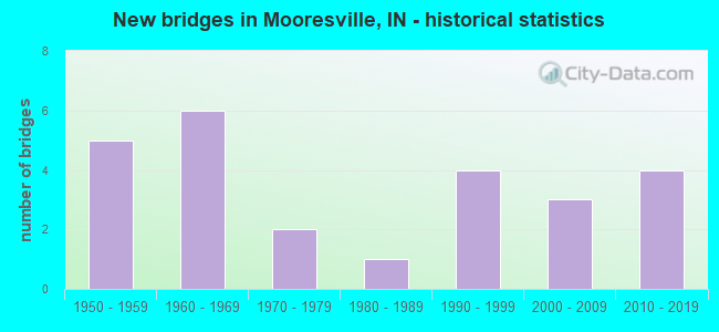
- New bridges - historical statistics
- 51950-1959
- 61960-1969
- 21970-1979
- 11980-1989
- 41990-1999
- 32000-2009
- 42010-2019
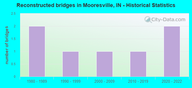
- Reconstructed bridges - Historical Statistics
- 21980-1989
- 11990-1999
- 12000-2009
- 12010-2019
- 22020-2022
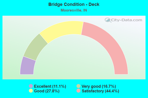
- Bridge Condition - Deck
- 11.1%Excellent
- 16.7%Very good
- 27.8%Good
- 44.4%Satisfactory
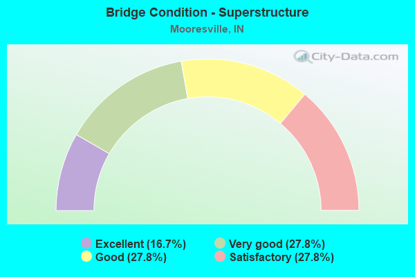
- Bridge Condition - Superstructure
- 16.7%Excellent
- 27.8%Very good
- 27.8%Good
- 27.8%Satisfactory
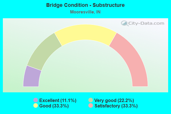
- Bridge Condition - Substructure
- 11.1%Excellent
- 22.2%Very good
- 33.3%Good
- 33.3%Satisfactory
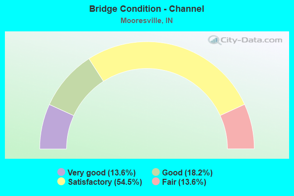
- Bridge Condition - Channel
- 13.6%Very good
- 18.2%Good
- 54.5%Satisfactory
- 13.6%Fair
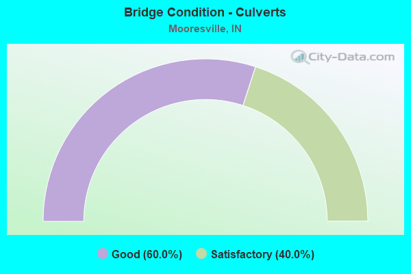
- Bridge Condition - Culverts
- 60.0%Good
- 40.0%Satisfactory
Find on map >> Show street view
Structure Number: 2411, Location: 08.82 S SR 44 (Lat: 39.394131, Lng: -85.757261), Route carried "on" structure: State highway 9, Year Built: 2013, Status: Open, Structure Length: 7.99m (26.21ft), Average Daily Traffic: 3,160 (year 2010), Truck Traffic: 12%, Average Future Daily Traffic: 3,260 (year 2030), Design Load: HL 93, Features Intersected: FLATROCK RIVER
Minimum Vertical Clearance: 30+ m (98+ ft), Kilometerpoint: 5.246, Lanes on structure: 2, Owner: State Highway Agency, Approaching Roadway Width: 9.1m (29.9ft), Material/Design: Prestressed concrete continuous, Design/Construction: Tee Beam, Number Of Spans In Main Unit: 2, Length of Maximum Span: 39.6m (129.9ft), Curb-To-Curb Width: 12.0m (39.4ft), Out-to-Out Width: 12.9m (42.3ft)
Condition: Deck: Very good, Superstructure: Very good, Substructure: Very good, Channel: Very good, Operating Rating: 51.8 metric tons, Method Used To Determine Operating Rating: Load and Resistance Factor Rating (LRFR) rating reported by rating factor(RF) method using HL-93 loadings, Inventory Rating: 30.1 metric tons, Method Used To Determine Inventory Rating: Load and Resistance Factor Rating (LRFR) rating reported by rating factor(RF) method using HL-93 loadings, Structural Evaluation: Better than present minimum criteria, Deck Geometry: Somewhat better than minimum adequacy, Waterway Adequacy: Superior to present desirable criteria, Approach Roadway Alignment: Equal to present minimum criteria, Designated Inspection Frequency: Every 24 months, Inspection Date: January 2021, Deck Structure Type: Concrete Cast-file-Place, Wearing Surface/Protective System: Wearing Surface: Monolithic Concrete, Deck Protection: Epoxy Coated Reinforcing
Find on map >> Show street view
Structure Number: 1588, Location: 00.43 W SR 267 (Lat: 39.608761, Lng: -86.382039), Route carried "on" structure: State highway 42, Year Built: 1963, Year Reconstructed: 2006, Status: Open, Structure Length: 13.30m (43.64ft), Average Daily Traffic: 7,760 (year 2006), Truck Traffic: 2%, Average Future Daily Traffic: 12,881 (year 2032), Design Load: HS 20, Features Intersected: WHITE LICK CREEK
Minimum Vertical Clearance: 30+ m (98+ ft), Kilometerpoint: 36.757, Lanes on structure: 2, Owner: State Highway Agency, Approaching Roadway Width: 7.0m (23.0ft), Skew: 2 degrees, Material/Design: Prestressed concrete continuous, Design/Construction: Stringer/Multi-beam, Number Of Spans In Main Unit: 6, Length of Maximum Span: 24.4m (80.1ft), Curb-To-Curb Width: 10.9m (35.8ft), Out-to-Out Width: 11.9m (39.0ft)
Condition: Deck: Good, Superstructure: Very good, Substructure: Good, Channel: Very good, Operating Rating: 34.7 metric tons, Method Used To Determine Operating Rating: Load and Resistance Factor Rating (LRFR) rating reported by rating factor(RF) method using HL-93 loadings, Inventory Rating: 26.6 metric tons, Method Used To Determine Inventory Rating: Load and Resistance Factor Rating (LRFR) rating reported by rating factor(RF) method using HL-93 loadings, Structural Evaluation: Equal to present minimum criteria, Deck Geometry: Meets minimum limits, Waterway Adequacy: Superior to present desirable criteria, Approach Roadway Alignment: Equal to present desirable criteria, Designated Inspection Frequency: Every 24 months, Inspection Date: April 2020, Deck Structure Type: Concrete Cast-file-Place, Wearing Surface/Protective System: Wearing Surface: Monolithic Concrete, Deck Protection: Epoxy Coated Reinforcing
Find on map >> Show street view
Structure Number: 2405, Location: 03.66 S SR 144 (Lat: 39.557919, Lng: -86.379389), Route carried "on" structure: State highway 67, Year Built: 1966, Status: Open, Structure Length: 1.28m (4.20ft), Average Daily Traffic: 17,774 (year 2004), Truck Traffic: 10%, Average Future Daily Traffic: 25,237 (year 2031), Design Load: HS 20, Features Intersected: MONICAL CREEK
Minimum Vertical Clearance: 30+ m (98+ ft), Kilometerpoint: 32.847, Lanes on structure: 4, Base Highway Network: Yes (, Subroute: 1), Owner: State Highway Agency, Approaching Roadway Width: 24.4m (80.1ft), Skew: 10 degrees, Material/Design: Concrete, Design/Construction: Culvert, Number Of Spans In Main Unit: 1, Length of Maximum Span: 12.2m (40.0ft), Curb-To-Curb Width: 24.4m (80.1ft), Out-to-Out Width: 36.6m (120.1ft)
Condition: Channel: Satisfactory, Culverts: Good, Inventory Rating: 88.2 metric tons, Method Used To Determine Inventory Rating: Field evaluation and documented engineering judgment, Structural Evaluation: Better than present minimum criteria, Deck Geometry: Superior to present desirable criteria, Waterway Adequacy: Better than present minimum criteria, Approach Roadway Alignment: Equal to present desirable criteria, Designated Inspection Frequency: Every 24 months, Inspection Date: Febuary 2021
Find on map >> Show street view
Structure Number: 2406, Location: 00.87 S SR 144 (Lat: 39.598669, Lng: -86.375481), Route carried "on" structure: State highway 67, Year Built: 1995, Status: Open, Structure Length: 12.28m (40.29ft), Average Daily Traffic: 12,716 (year 2004), Truck Traffic: 5%, Average Future Daily Traffic: 19,191 (year 2031), Design Load: HS 20, Features Intersected: WHITE LICK CREEK
Minimum Vertical Clearance: 30+ m (98+ ft), Kilometerpoint: 37.337, Lanes on structure: 2, Base Highway Network: Yes (, Subroute: 1), Owner: State Highway Agency, Approaching Roadway Width: 12.8m (42.0ft), Material/Design: Steel continuous, Design/Construction: Stringer/Multi-beam, Number Of Spans In Main Unit: 6, Length of Maximum Span: 23.8m (78.1ft), Curb-To-Curb Width: 12.0m (39.4ft), Out-to-Out Width: 12.9m (42.3ft)
Condition: Deck: Good, Superstructure: Good, Substructure: Good, Channel: Fair, Operating Rating: 45.0 metric tons, Method Used To Determine Operating Rating: Load and Resistance Factor Rating (LRFR) rating reported by rating factor(RF) method using HL-93 loadings, Inventory Rating: 34.7 metric tons, Method Used To Determine Inventory Rating: Load and Resistance Factor Rating (LRFR) rating reported by rating factor(RF) method using HL-93 loadings, Structural Evaluation: Better than present minimum criteria, Deck Geometry: Better than present minimum criteria, Waterway Adequacy: Equal to present desirable criteria, Approach Roadway Alignment: Equal to present desirable criteria, Designated Inspection Frequency: Every 24 months, Inspection Date: Febuary 2021, Deck Structure Type: Concrete Cast-file-Place, Wearing Surface/Protective System: Wearing Surface: Monolithic Concrete, Deck Protection: Epoxy Coated Reinforcing
Find on map >> Show street view
Structure Number: 2407, Location: 00.87 S SR 144 (Lat: 39.598769, Lng: -86.375739), Route carried "on" structure: State highway 67, Year Built: 1958, Year Reconstructed: 1996, Status: Open, Structure Length: 12.71m (41.70ft), Average Daily Traffic: 12,716 (year 2004), Truck Traffic: 5%, Average Future Daily Traffic: 19,191 (year 2031), Design Load: HS 20, Features Intersected: WHITE LICK CREEK
Minimum Vertical Clearance: 30+ m (98+ ft), Kilometerpoint: 37.337, Lanes on structure: 2, Base Highway Network: Yes (, Subroute: 1), Owner: State Highway Agency, Approaching Roadway Width: 11.6m (38.1ft), Material/Design: Steel continuous, Design/Construction: Stringer/Multi-beam, Number Of Spans In Main Unit: 5, Number Of Approach Spans: 1, Length of Maximum Span: 23.8m (78.1ft), Curb-To-Curb Width: 11.8m (38.7ft), Out-to-Out Width: 12.7m (41.7ft)
Condition: Deck: Satisfactory, Superstructure: Good, Substructure: Good, Channel: Fair, Operating Rating: 39.9 metric tons, Method Used To Determine Operating Rating: Load and Resistance Factor Rating (LRFR) rating reported by rating factor(RF) method using HL-93 loadings, Inventory Rating: 30.8 metric tons, Method Used To Determine Inventory Rating: Load and Resistance Factor Rating (LRFR) rating reported by rating factor(RF) method using HL-93 loadings, Structural Evaluation: Better than present minimum criteria, Deck Geometry: Better than present minimum criteria, Waterway Adequacy: Better than present minimum criteria, Approach Roadway Alignment: Equal to present desirable criteria, Designated Inspection Frequency: Every 24 months, Inspection Date: Febuary 2021, Deck Structure Type: Concrete Cast-file-Place, Wearing Surface/Protective System: Wearing Surface: Monolithic Concrete, Deck Protection: Epoxy Coated Reinforcing
Find on map >> Show street view
Structure Number: 2408, Location: 00.10 S SR 144 (Lat: 39.606761, Lng: -86.366619), Route carried "on" structure: State highway 67, Year Built: 1958, Year Reconstructed: 2020, Status: Open, Structure Length: 5.34m (17.52ft), Average Daily Traffic: 11,973 (year 2021), Truck Traffic: 5%, Average Future Daily Traffic: 12,968 (year 2041), Design Load: HL 93, Features Intersected: LITTLE WHITE LICK CREEK
Minimum Vertical Clearance: 30+ m (98+ ft), Kilometerpoint: 38.576, Lanes on structure: 2, Base Highway Network: Yes (, Subroute: 1), Owner: State Highway Agency, Approaching Roadway Width: 10.4m (34.1ft), Skew: 2 degrees, Material/Design: Prestressed concrete, Design/Construction: Box Beam or Girders - Single/Spread, Number Of Spans In Main Unit: 4, Length of Maximum Span: 13.2m (43.3ft), Curb-To-Curb Width: 10.4m (34.1ft), Out-to-Out Width: 11.3m (37.1ft)
Condition: Deck: Excellent, Superstructure: Excellent, Substructure: Very good, Channel: Satisfactory, Operating Rating: 62.5 metric tons, Method Used To Determine Operating Rating: Load and Resistance Factor Rating (LRFR) rating reported by rating factor(RF) method using HL-93 loadings, Inventory Rating: 34.0 metric tons, Method Used To Determine Inventory Rating: Load and Resistance Factor Rating (LRFR) rating reported by rating factor(RF) method using HL-93 loadings, Structural Evaluation: Equal to present desirable criteria, Deck Geometry: Somewhat better than minimum adequacy, Waterway Adequacy: Better than present minimum criteria, Approach Roadway Alignment: Equal to present desirable criteria, Designated Inspection Frequency: Every 24 months, Inspection Date: Febuary 2021, Deck Structure Type: Concrete Cast-file-Place, Wearing Surface/Protective System: Wearing Surface: Monolithic Concrete, Deck Protection: Epoxy Coated Reinforcing
Find on map >> Show street view
Structure Number: 2409, Location: 00.10 S SR 144 (Lat: 39.606969, Lng: -86.366631), Route carried "on" structure: State highway 67, Year Built: 1958, Year Reconstructed: 2020, Status: Open, Structure Length: 5.34m (17.52ft), Average Daily Traffic: 11,973 (year 2021), Truck Traffic: 5%, Average Future Daily Traffic: 12,968 (year 2041), Design Load: HL 93, Features Intersected: LITTLE WHITE LICK CREEK
Minimum Vertical Clearance: 30+ m (98+ ft), Kilometerpoint: 38.576, Lanes on structure: 2, Base Highway Network: Yes (, Subroute: 1), Owner: State Highway Agency, Approaching Roadway Width: 10.4m (34.1ft), Skew: 2 degrees, Material/Design: Prestressed concrete, Design/Construction: Box Beam or Girders - Single/Spread, Number Of Spans In Main Unit: 4, Length of Maximum Span: 13.2m (43.3ft), Curb-To-Curb Width: 10.4m (34.1ft), Out-to-Out Width: 11.3m (37.1ft)
Condition: Deck: Excellent, Superstructure: Excellent, Substructure: Very good, Channel: Satisfactory, Operating Rating: 62.5 metric tons, Method Used To Determine Operating Rating: Load and Resistance Factor Rating (LRFR) rating reported by rating factor(RF) method using HL-93 loadings, Inventory Rating: 34.0 metric tons, Method Used To Determine Inventory Rating: Load and Resistance Factor Rating (LRFR) rating reported by rating factor(RF) method using HL-93 loadings, Structural Evaluation: Equal to present desirable criteria, Deck Geometry: Meets minimum limits, Waterway Adequacy: Better than present minimum criteria, Approach Roadway Alignment: Equal to present desirable criteria, Designated Inspection Frequency: Every 24 months, Inspection Date: Febuary 2021, Deck Structure Type: Concrete Cast-file-Place, Wearing Surface/Protective System: Wearing Surface: Monolithic Concrete, Deck Protection: Epoxy Coated Reinforcing
Find on map >> Show street view
Structure Number: 241, Location: 01.70 N SR 144 (Lat: 39.628050, Lng: -86.351311), Route carried "on" structure: State highway 67, Year Built: 1958, Year Reconstructed: 1993, Status: Open, Structure Length: 2.49m (8.17ft), Average Daily Traffic: 12,301 (year 2004), Truck Traffic: 5%, Average Future Daily Traffic: 18,000 (year 2030), Design Load: HS 20, Features Intersected: SILON CRK (MOONS BRANCH)
Minimum Vertical Clearance: 30+ m (98+ ft), Kilometerpoint: 41.473, Lanes on structure: 2, Base Highway Network: Yes (, Subroute: 1), Owner: State Highway Agency, Approaching Roadway Width: 11.9m (39.0ft), Skew: 3 degrees, Material/Design: Concrete continuous, Design/Construction: Slab, Number Of Spans In Main Unit: 3, Length of Maximum Span: 9.8m (32.2ft), Curb-To-Curb Width: 12.2m (40.0ft), Out-to-Out Width: 13.1m (43.0ft)
Condition: Deck: Satisfactory, Superstructure: Satisfactory, Substructure: Satisfactory, Channel: Satisfactory, Operating Rating: 41.1 metric tons, Method Used To Determine Operating Rating: Load and Resistance Factor Rating (LRFR) rating reported by rating factor(RF) method using HL-93 loadings, Inventory Rating: 31.8 metric tons, Method Used To Determine Inventory Rating: Load and Resistance Factor Rating (LRFR) rating reported by rating factor(RF) method using HL-93 loadings, Structural Evaluation: Equal to present minimum criteria, Deck Geometry: Better than present minimum criteria, Waterway Adequacy: Better than present minimum criteria, Approach Roadway Alignment: Equal to present desirable criteria, Designated Inspection Frequency: Every 24 months, Inspection Date: March 2021, Deck Structure Type: Concrete Cast-file-Place, Wearing Surface/Protective System: Wearing Surface: Latex Concrete
Find on map >> Show street view
Structure Number: 2411, Location: 01.70 N SR 144 (Lat: 39.628039, Lng: -86.351611), Route carried "on" structure: State highway 67, Year Built: 1958, Year Reconstructed: 1993, Status: Open, Structure Length: 2.49m (8.17ft), Average Daily Traffic: 12,301 (year 2004), Truck Traffic: 5%, Average Future Daily Traffic: 17,332 (year 2030), Design Load: HS 20, Features Intersected: SILON CRK (MOONS BRANCH)
Minimum Vertical Clearance: 30+ m (98+ ft), Kilometerpoint: 41.473, Lanes on structure: 3, Base Highway Network: Yes (, Subroute: 1), Owner: State Highway Agency, Approaching Roadway Width: 11.9m (39.0ft), Skew: 3 degrees, Material/Design: Concrete continuous, Design/Construction: Slab, Number Of Spans In Main Unit: 3, Length of Maximum Span: 9.8m (32.2ft), Curb-To-Curb Width: 15.9m (52.2ft), Out-to-Out Width: 16.8m (55.1ft)
Condition: Deck: Satisfactory, Superstructure: Satisfactory, Substructure: Satisfactory, Channel: Satisfactory, Operating Rating: 43.4 metric tons, Method Used To Determine Operating Rating: Load and Resistance Factor Rating (LRFR) rating reported by rating factor(RF) method using HL-93 loadings, Inventory Rating: 33.7 metric tons, Method Used To Determine Inventory Rating: Load and Resistance Factor Rating (LRFR) rating reported by rating factor(RF) method using HL-93 loadings, Structural Evaluation: Equal to present minimum criteria, Deck Geometry: Somewhat better than minimum adequacy, Waterway Adequacy: Superior to present desirable criteria, Approach Roadway Alignment: Equal to present desirable criteria, Designated Inspection Frequency: Every 24 months, Inspection Date: March 2021, Deck Structure Type: Concrete Cast-file-Place, Wearing Surface/Protective System: Wearing Surface: Latex Concrete
Find on map >> Show street view
Structure Number: 4182, Location: 03.12 E SR 39 (Lat: 39.638231, Lng: -86.432281), Route carried "on" structure: County highway , Year Built: 1966, Year Reconstructed: 2016, Status: Open, Structure Length: 8.02m (26.31ft), Average Daily Traffic: 950 (year 2016), Truck Traffic: 4%, Average Future Daily Traffic: 1,110 (year 2026), Design Load: HS 20, Features Intersected: I-70 EB/WB, Facility Carried by Structure: CR 525E
Minimum Vertical Clearance: 30+ m (98+ ft), Kilometerpoint: 0.000, Lanes on structure: 2, Lanes under structure: 4, Owner: State Highway Agency, Approaching Roadway Width: 6.1m (20.0ft), Skew: 3 degrees, Material/Design: Steel continuous, Design/Construction: Stringer/Multi-beam, Number Of Spans In Main Unit: 2, Number Of Approach Spans: 2, Length of Maximum Span: 25.9m (85.0ft), Curb or Sidewalk Widths: Left: 0.4m (1.3ft), Right: 0.4m (1.3ft), Curb-To-Curb Width: 7.3m (24.0ft), Out-to-Out Width: 8.9m (29.2ft)
Condition: Deck: Satisfactory, Superstructure: Satisfactory, Substructure: Good, Operating Rating: 30.5 metric tons, Method Used To Determine Operating Rating: Load and Resistance Factor Rating (LRFR) rating reported by rating factor(RF) method using HL-93 loadings, Inventory Rating: 23.7 metric tons, Method Used To Determine Inventory Rating: Load and Resistance Factor Rating (LRFR) rating reported by rating factor(RF) method using HL-93 loadings, Structural Evaluation: Equal to present minimum criteria, Deck Geometry: Meets minimum limits, Underclear: Meets minimum limits, Approach Roadway Alignment: Equal to present desirable criteria, Designated Inspection Frequency: Every 24 months, Inspection Date: June 2021, Deck Structure Type: Concrete Cast-file-Place, Wearing Surface/Protective System: Wearing Surface: Epoxy Overlay
Find on map >> Show street view
Structure Number: 76498, Location: 01.90 E SR 67 (Lat: 39.596811, Lng: -86.345769), Route carried "on" structure: State highway 144, Year Built: 2008, Status: Open, Structure Length: 0.65m (2.13ft), Average Daily Traffic: 15,700 (year 2007), Truck Traffic: 3%, Average Future Daily Traffic: 22,081 (year 2031), Design Load: HS 20, Features Intersected: EAST FK WHITE LICK CREEK
Minimum Vertical Clearance: 30+ m (98+ ft), Kilometerpoint: 3.058, Lanes on structure: 2, Owner: State Highway Agency, Approaching Roadway Width: 9.8m (32.2ft), Skew: 1 degrees, Material/Design: Steel, Design/Construction: Culvert, Number Of Spans In Main Unit: 1, Length of Maximum Span: 6.5m (21.3ft), Curb-To-Curb Width: 9.8m (32.2ft), Out-to-Out Width: 9.8m (32.2ft)
Condition: Channel: Good, Culverts: Good, Operating Rating: 86.2 metric tons, Method Used To Determine Operating Rating: Load and Resistance Factor Rating (LRFR) rating reported by rating factor(RF) method using HL-93 loadings, Inventory Rating: 66.4 metric tons, Method Used To Determine Inventory Rating: Load and Resistance Factor Rating (LRFR) rating reported by rating factor(RF) method using HL-93 loadings, Structural Evaluation: Better than present minimum criteria, Deck Geometry: Meets minimum limits, Waterway Adequacy: Better than present minimum criteria, Approach Roadway Alignment: Equal to present desirable criteria, Designated Inspection Frequency: Every 24 months, Inspection Date: September 2020
Find on map >> Show street view
Structure Number: 3200159, Location: 00.30 W OF SR 267 (Lat: 39.630689, Lng: -86.391431), Route carried "on" structure: County highway 8, Year Built: 1990, Status: Open, Structure Length: 7.68m (25.20ft), Average Daily Traffic: 1,875 (year 2018), Truck Traffic: 12%, Average Future Daily Traffic: 3,075 (year 2038), Design Load: HS 20, Features Intersected: WHITE LICK CREEK, Facility Carried by Structure: CR 900S
Minimum Vertical Clearance: 30+ m (98+ ft), Kilometerpoint: 0.000, Lanes on structure: 2, Owner: County Highway Agency, Approaching Roadway Width: 7.3m (24.0ft), Material/Design: Prestressed concrete continuous, Design/Construction: Stringer/Multi-beam, Number Of Spans In Main Unit: 3, Length of Maximum Span: 27.1m (88.9ft), Curb-To-Curb Width: 8.5m (27.9ft), Out-to-Out Width: 9.4m (30.8ft)
Condition: Deck: Good, Superstructure: Very good, Substructure: Satisfactory, Channel: Satisfactory, Inventory Rating: 34.6 metric tons, Method Used To Determine Inventory Rating: Load Factor (LF), Structural Evaluation: Equal to present minimum criteria, Deck Geometry: Somewhat better than minimum adequacy, Waterway Adequacy: Equal to present desirable criteria, Approach Roadway Alignment: Equal to present desirable criteria, Designated Inspection Frequency: Every 24 months, Inspection Date: June 2020, Deck Structure Type: Concrete Cast-file-Place, Wearing Surface/Protective System: Wearing Surface: Monolithic Concrete, Deck Protection: Epoxy Coated Reinforcing
Find on map >> Show street view
Structure Number: 3200907, Location: 00.11 S OF CR 800 S (Lat: 39.644839, Lng: -86.342769), Route carried "on" structure: County highway , Year Built: 2008, Status: Open, Structure Length: 1.42m (4.66ft), Average Daily Traffic: 2,375 (year 2018), Truck Traffic: 5%, Average Future Daily Traffic: 3,900 (year 2038), Features Intersected: RAIL RUN, Facility Carried by Structure: CR 1025E
Minimum Vertical Clearance: 30+ m (98+ ft), Kilometerpoint: 0.000, Lanes on structure: 2, Owner: County Highway Agency, Approaching Roadway Width: 7.3m (24.0ft), Material/Design: Prestressed concrete, Design/Construction: Box Beam or Girders - Multiple, Number Of Spans In Main Unit: 1, Length of Maximum Span: 12.6m (41.3ft), Curb-To-Curb Width: 9.7m (31.8ft), Out-to-Out Width: 9.8m (32.2ft)
Condition: Deck: Satisfactory, Superstructure: Very good, Substructure: Very good, Channel: Good, Operating Rating: 88.7 metric tons, Method Used To Determine Operating Rating: Load Factor (LF), Inventory Rating: 52.1 metric tons, Method Used To Determine Inventory Rating: Load Factor (LF), Structural Evaluation: Equal to present desirable criteria, Deck Geometry: Meets minimum limits, Waterway Adequacy: Better than present minimum criteria, Approach Roadway Alignment: Equal to present desirable criteria, Designated Inspection Frequency: Every 24 months, Inspection Date: June 2020, Deck Structure Type: Concrete Cast-file-Place, Wearing Surface/Protective System: Wearing Surface: Monolithic Concrete, Deck Protection: Epoxy Coated Reinforcing
Find on map >> Show street view
Structure Number: 5500071, Location: 00.04 S OF LINDLEY RD (Lat: 39.578961, Lng: -86.402764), Route carried "on" structure: County highway 259, Year Built: 1968, Status: Open, Structure Length: 1.14m (3.74ft), Average Daily Traffic: 1,730 (year 2018), Truck Traffic: 5%, Average Future Daily Traffic: 3,030 (year 2038), Features Intersected: FORK OF MONICAL CREEK, Facility Carried by Structure: BUNKERHILL RD
Minimum Vertical Clearance: 30+ m (98+ ft), Kilometerpoint: 0.000, Lanes on structure: 2, Owner: County Highway Agency, Approaching Roadway Width: 5.5m (18.0ft), Material/Design: Prestressed concrete, Design/Construction: Box Beam or Girders - Multiple, Number Of Spans In Main Unit: 1, Length of Maximum Span: 10.7m (35.1ft), Curb or Sidewalk Widths: Left: 0.3m (1.0ft), Right: 0.3m (1.0ft), Curb-To-Curb Width: 6.8m (22.3ft), Out-to-Out Width: 7.4m (24.3ft)
Condition: Deck: Satisfactory, Superstructure: Satisfactory, Substructure: Satisfactory, Channel: Fair, Operating Rating: 44.5 metric tons, Method Used To Determine Operating Rating: Load and Resistance Factor (LRFR), Inventory Rating: 29.4 metric tons, Method Used To Determine Inventory Rating: Load and Resistance Factor (LRFR), Structural Evaluation: Equal to present minimum criteria, Deck Geometry: High priority of corrective action, Waterway Adequacy: Equal to present minimum criteria, Approach Roadway Alignment: Equal to present minimum criteria, Designated Inspection Frequency: Every 24 months, Inspection Date: August 2020, Deck Structure Type: Concrete Precast Panels, Wearing Surface/Protective System: Wearing Surface: Bituminous
Find on map >> Show street view
Structure Number: 5500106, Location: 00.60 N OF SHADY LN (Lat: 39.585569, Lng: -86.353172), Route carried "on" structure: County highway 279, Year Built: 1981, Status: Open, Structure Length: 1.07m (3.51ft), Average Daily Traffic: 680 (year 2018), Truck Traffic: 5%, Average Future Daily Traffic: 1,190 (year 2038), Design Load: HS 20, Features Intersected: BRANCHOFWHITE LICK CREEK, Facility Carried by Structure: ROOKER RD
Minimum Vertical Clearance: 30+ m (98+ ft), Kilometerpoint: 0.000, Lanes on structure: 2, Owner: County Highway Agency, Approaching Roadway Width: 6.1m (20.0ft), Skew: 1 degrees, Material/Design: Aluminum, Iron, Design/Construction: Culvert, Number Of Spans In Main Unit: 2, Length of Maximum Span: 4.9m (16.1ft), Curb-To-Curb Width: 8.7m (28.5ft), Out-to-Out Width: 8.7m (28.5ft)
Condition: Channel: Satisfactory, Culverts: Satisfactory, Operating Rating: 61.3 metric tons, Method Used To Determine Operating Rating: Load and Resistance Factor (LRFR), Inventory Rating: 39.8 metric tons, Method Used To Determine Inventory Rating: Load and Resistance Factor (LRFR), Structural Evaluation: Equal to present minimum criteria, Deck Geometry: Somewhat better than minimum adequacy, Waterway Adequacy: Better than present minimum criteria, Approach Roadway Alignment: Equal to present minimum criteria, Designated Inspection Frequency: Every 24 months, Inspection Date: August 2020
Find on map >> Show street view
Structure Number: 5500111, Location: 00.32 E OF 480 E (Lat: 39.596000, Lng: -86.330933), Route carried "on" structure: County highway 244, Year Built: 1976, Status: Open, Structure Length: 1.19m (3.90ft), Average Daily Traffic: 80 (year 2018), Truck Traffic: 5%, Average Future Daily Traffic: 140 (year 2038), Design Load: HS 20, Features Intersected: BRANCH OF WHITE LICK CRE, Facility Carried by Structure: NEITZEL RD
Minimum Vertical Clearance: 30+ m (98+ ft), Kilometerpoint: 0.000, Lanes on structure: 2, Owner: County Highway Agency, Approaching Roadway Width: 5.5m (18.0ft), Skew: 4 degrees, Material/Design: Aluminum, Iron, Design/Construction: Culvert, Number Of Spans In Main Unit: 2, Length of Maximum Span: 4.4m (14.4ft), Curb-To-Curb Width: 7.9m (25.9ft), Out-to-Out Width: 7.9m (25.9ft)
Condition: Channel: Satisfactory, Culverts: Satisfactory, Operating Rating: 46.1 metric tons, Method Used To Determine Operating Rating: Load and Resistance Factor (LRFR), Inventory Rating: 39.2 metric tons, Method Used To Determine Inventory Rating: Load and Resistance Factor (LRFR), Structural Evaluation: Equal to present minimum criteria, Deck Geometry: Equal to present minimum criteria, Waterway Adequacy: Equal to present minimum criteria, Approach Roadway Alignment: Equal to present minimum criteria, Designated Inspection Frequency: Every 24 months, Inspection Date: August 2020
Find on map >> Show street view
Structure Number: 5500118, Location: 00.16 S OF E 875 S (Lat: 39.629789, Lng: -86.431900), Route carried "on" structure: County highway 219, Year Built: 1994, Status: Open, Structure Length: 3.15m (10.33ft), Average Daily Traffic: 230 (year 2018), Truck Traffic: 5%, Average Future Daily Traffic: 400 (year 2038), Design Load: HS 20, Features Intersected: MCCRACKEN CREEK, Facility Carried by Structure: HAMMER RD
Minimum Vertical Clearance: 30+ m (98+ ft), Kilometerpoint: 0.000, Lanes on structure: 2, Owner: County Highway Agency, Approaching Roadway Width: 6.1m (20.0ft), Skew: 2 degrees, Material/Design: Concrete continuous, Design/Construction: Slab, Number Of Spans In Main Unit: 3, Length of Maximum Span: 12.2m (40.0ft), Curb-To-Curb Width: 7.3m (24.0ft), Out-to-Out Width: 7.5m (24.6ft)
Condition: Deck: Good, Superstructure: Good, Substructure: Satisfactory, Channel: Satisfactory, Operating Rating: 55.4 metric tons, Method Used To Determine Operating Rating: Load and Resistance Factor (LRFR), Inventory Rating: 41.2 metric tons, Method Used To Determine Inventory Rating: Load and Resistance Factor (LRFR), Structural Evaluation: Equal to present minimum criteria, Deck Geometry: Somewhat better than minimum adequacy, Waterway Adequacy: Better than present minimum criteria, Approach Roadway Alignment: Equal to present minimum criteria, Designated Inspection Frequency: Every 24 months, Inspection Date: August 2020, Deck Structure Type: Concrete Cast-file-Place, Wearing Surface/Protective System: Wearing Surface: Monolithic Concrete, Deck Protection: Epoxy Coated Reinforcing
Find on map >> Show street view
Structure Number: 550013, Location: 00.34 W OF SR 67 (Lat: 39.623939, Lng: -86.357308), Route carried "on" structure: City street 397, Year Built: 1994, Status: Open, Structure Length: 5.52m (18.11ft), Average Daily Traffic: 6,000 (year 2018), Truck Traffic: 10%, Average Future Daily Traffic: 10,500 (year 2038), Design Load: HS 20, Features Intersected: BRANCH OF WHITE LICK RIV, Facility Carried by Structure: SAMUEL MOORE PKWY
Minimum Vertical Clearance: 30+ m (98+ ft), Kilometerpoint: 0.000, Lanes on structure: 2, Owner: County Highway Agency, Approaching Roadway Width: 7.3m (24.0ft), Skew: 4 degrees, Material/Design: Prestressed concrete continuous, Design/Construction: Stringer/Multi-beam, Number Of Spans In Main Unit: 3, Length of Maximum Span: 18.6m (61.0ft), Curb-To-Curb Width: 13.3m (43.6ft), Out-to-Out Width: 14.3m (46.9ft)
Condition: Deck: Good, Superstructure: Good, Substructure: Good, Channel: Satisfactory, Operating Rating: 69.9 metric tons, Method Used To Determine Operating Rating: Load and Resistance Factor (LRFR), Inventory Rating: 47.6 metric tons, Method Used To Determine Inventory Rating: Load and Resistance Factor (LRFR), Structural Evaluation: Better than present minimum criteria, Deck Geometry: Somewhat better than minimum adequacy, Waterway Adequacy: Equal to present desirable criteria, Approach Roadway Alignment: Equal to present desirable criteria, Designated Inspection Frequency: Every 24 months, Inspection Date: August 2020, Deck Structure Type: Concrete Cast-file-Place, Wearing Surface/Protective System: Wearing Surface: Monolithic Concrete, Deck Protection: Epoxy Coated Reinforcing
Find on map >> Show street view
Structure Number: 5500151, Location: 00.29 W OF SR 67 (Lat: 39.616419, Lng: -86.360694), Route carried "on" structure: City street , Year Built: 1974, Status: Open, Structure Length: 6.26m (20.54ft), Average Daily Traffic: 6,880 (year 2018), Truck Traffic: 5%, Average Future Daily Traffic: 12,040 (year 2038), Design Load: HS 20, Features Intersected: EAST FORK OF WHITE LICK, Facility Carried by Structure: BRIDGE ST
Minimum Vertical Clearance: 30+ m (98+ ft), Kilometerpoint: 0.000, Lanes on structure: 2, Owner: County Highway Agency, Approaching Roadway Width: 6.7m (22.0ft), Skew: 3 degrees, Material/Design: Prestressed concrete continuous, Design/Construction: Stringer/Multi-beam, Number Of Spans In Main Unit: 3, Length of Maximum Span: 24.7m (81.0ft), Curb-To-Curb Width: 8.5m (27.9ft), Out-to-Out Width: 9.3m (30.5ft)
Condition: Deck: Satisfactory, Superstructure: Satisfactory, Substructure: Satisfactory, Channel: Satisfactory, Operating Rating: 74.8 metric tons, Method Used To Determine Operating Rating: Load and Resistance Factor (LRFR), Inventory Rating: 55.6 metric tons, Method Used To Determine Inventory Rating: Load and Resistance Factor (LRFR), Structural Evaluation: Equal to present minimum criteria, Deck Geometry: Meets minimum limits, Waterway Adequacy: Equal to present desirable criteria, Approach Roadway Alignment: Equal to present desirable criteria, Length Of Structure Improvement: 6.25m (20.51ft), Designated Inspection Frequency: Every 24 months, Inspection Date: August 2020, Bridge Improvement Cost: $503,000, Roadway Improvement Cost: $174,000, Total Project Cost: $820,000 ( Estimate for 2018), Deck Structure Type: Concrete Cast-file-Place, Wearing Surface/Protective System: Wearing Surface: Monolithic Concrete
Find on map >> Show street view
Structure Number: 5500163, Location: 00.23 N OF 1350 N (Lat: 39.627569, Lng: -86.345422), Route carried "on" structure: County highway 353, Year Built: 2001, Status: Open, Structure Length: 0.69m (2.26ft), Average Daily Traffic: 370 (year 2018), Truck Traffic: 5%, Average Future Daily Traffic: 60 (year 2038), Design Load: HS 20, Features Intersected: BRANCH OF SILON CREEK, Facility Carried by Structure: FERGUSON RD
Minimum Vertical Clearance: 30+ m (98+ ft), Kilometerpoint: 0.000, Lanes on structure: 2, Owner: County Highway Agency, Approaching Roadway Width: 5.5m (18.0ft), Skew: 1 degrees, Material/Design: Aluminum, Iron, Design/Construction: Culvert, Number Of Spans In Main Unit: 1, Length of Maximum Span: 6.7m (22.0ft), Curb-To-Curb Width: 6.9m (22.6ft), Out-to-Out Width: 6.9m (22.6ft)
Condition: Channel: Good, Culverts: Good, Operating Rating: 69.2 metric tons, Method Used To Determine Operating Rating: Load and Resistance Factor (LRFR), Inventory Rating: 45.0 metric tons, Method Used To Determine Inventory Rating: Load and Resistance Factor (LRFR), Structural Evaluation: Better than present minimum criteria, Deck Geometry: Meets minimum limits, Waterway Adequacy: Better than present minimum criteria, Approach Roadway Alignment: Equal to present desirable criteria, Designated Inspection Frequency: Every 24 months, Inspection Date: August 2020
Find on map >> Show street view
Structure Number: 5500171, Location: 00.60 E OF WHITELICK RD (Lat: 39.613111, Lng: -86.385467), Route carried "on" structure: County highway 44, Year Built: 2010, Status: Open, Structure Length: 9.45m (31.00ft), Average Daily Traffic: 4,420 (year 2018), Truck Traffic: 5%, Average Future Daily Traffic: 7,740 (year 2038), Design Load: HS 20, Features Intersected: WHITE LICK CREEK, Facility Carried by Structure: GREENCASTLE RD
Minimum Vertical Clearance: 30+ m (98+ ft), Kilometerpoint: 0.000, Lanes on structure: 2, Owner: County Highway Agency, Approaching Roadway Width: 12.8m (42.0ft), Skew: 2 degrees, Material/Design: Prestressed concrete, Design/Construction: Tee Beam, Number Of Spans In Main Unit: 3, Length of Maximum Span: 33.5m (109.9ft), Curb-To-Curb Width: 12.6m (41.3ft), Out-to-Out Width: 13.5m (44.3ft)
Condition: Deck: Satisfactory, Superstructure: Good, Substructure: Good, Channel: Good, Operating Rating: 74.6 metric tons, Method Used To Determine Operating Rating: Load and Resistance Factor (LRFR), Inventory Rating: 33.0 metric tons, Method Used To Determine Inventory Rating: Load and Resistance Factor (LRFR), Structural Evaluation: Better than present minimum criteria, Deck Geometry: Equal to present minimum criteria, Waterway Adequacy: Equal to present desirable criteria, Approach Roadway Alignment: Equal to present desirable criteria, Designated Inspection Frequency: Every 24 months, Inspection Date: August 2020, Deck Structure Type: Concrete Cast-file-Place, Wearing Surface/Protective System: Wearing Surface: Monolithic Concrete
Find on map >> Show street view
Structure Number: 550018, Location: 00.92 N OF 65 S (Lat: 39.429831, Lng: -86.268411), Route carried "on" structure: County highway 321, Year Built: 2016, Status: Open, Structure Length: 2.65m (8.69ft), Average Daily Traffic: 200 (year 2018), Truck Traffic: 3%, Average Future Daily Traffic: 350 (year 2038), Design Load: HL 93, Features Intersected: STOTTS CREEK, Facility Carried by Structure: PEAVINE RD
Minimum Vertical Clearance: 30+ m (98+ ft), Kilometerpoint: 0.000, Lanes on structure: 2, Owner: County Highway Agency, Approaching Roadway Width: 7.6m (24.9ft), Material/Design: Concrete continuous, Design/Construction: Slab, Number Of Spans In Main Unit: 3, Length of Maximum Span: 10.4m (34.1ft), Curb-To-Curb Width: 8.8m (28.9ft), Out-to-Out Width: 9.0m (29.5ft)
Condition: Deck: Very good, Superstructure: Very good, Substructure: Excellent, Channel: Satisfactory, Operating Rating: 78.7 metric tons, Method Used To Determine Operating Rating: Load and Resistance Factor (LRFR), Inventory Rating: 58.5 metric tons, Method Used To Determine Inventory Rating: Load and Resistance Factor (LRFR), Structural Evaluation: Equal to present desirable criteria, Deck Geometry: Equal to present minimum criteria, Waterway Adequacy: Somewhat better than minimum adequacy, Approach Roadway Alignment: Equal to present minimum criteria, Designated Inspection Frequency: Every 24 months, Inspection Date: August 2020, Deck Structure Type: Concrete Cast-file-Place, Wearing Surface/Protective System: Wearing Surface: Monolithic Concrete
Find on map >> Show street view
Structure Number: 5500188, Location: 00.74 S OF HENDRICKS CO R (Lat: 39.619781, Lng: -86.394119), Route carried "on" structure: County highway 269, Year Built: 2016, Status: Open, Structure Length: 3.35m (10.99ft), Average Daily Traffic: 730 (year 2018), Truck Traffic: 5%, Average Future Daily Traffic: 1,280 (year 2038), Design Load: HL 93, Features Intersected: MCCRACKEN CREEK, Facility Carried by Structure: WHITE LICK RD
Minimum Vertical Clearance: 30+ m (98+ ft), Kilometerpoint: 0.000, Lanes on structure: 2, Owner: County Highway Agency, Approaching Roadway Width: 6.7m (22.0ft), Skew: 1 degrees, Material/Design: Prestressed concrete, Design/Construction: Box Beam or Girders - Single/Spread, Number Of Spans In Main Unit: 3, Length of Maximum Span: 15.5m (50.9ft), Curb-To-Curb Width: 9.4m (30.8ft), Out-to-Out Width: 9.6m (31.5ft)
Condition: Deck: Very good, Superstructure: Excellent, Substructure: Excellent, Channel: Very good, Operating Rating: 52.2 metric tons, Method Used To Determine Operating Rating: Load and Resistance Factor (LRFR), Inventory Rating: 43.2 metric tons, Method Used To Determine Inventory Rating: Load and Resistance Factor (LRFR), Structural Evaluation: Superior to present desirable criteria, Deck Geometry: Equal to present minimum criteria, Waterway Adequacy: Equal to present desirable criteria, Approach Roadway Alignment: Equal to present minimum criteria, Designated Inspection Frequency: Every 24 months, Inspection Date: August 2020, Deck Structure Type: Concrete Cast-file-Place, Wearing Surface/Protective System: Wearing Surface: Monolithic Concrete
Find on map >> Show street view
Structure Number: 4182, Location: 03.12 E SR 39 (Lat: 39.638231, Lng: -86.432281), Route carried "under" structure: Interstate 70, Year Built: 1966, Structure Length: 0. m, Average Daily Traffic: 22,310 (year 2010), Truck Traffic: 36%, Features Intersected: I-70 EBL, Facility Carried by Structure: CR 525E
Minimum Vertical Clearance: 4.95m (16.24ft), Kilometerpoint: 100.310, Lanes on structure: 2, Lanes under structure: 4, Material/Design: Steel continuous, Design/Construction: Stringer/Multi-beam, Length of Maximum Span: 25.9m (85.0ft)
Find on map >> Show street view
Structure Number: 4182, Location: 03.12 E SR 39 (Lat: 39.638231, Lng: -86.432281), Route carried "under" structure: Interstate 70, Year Built: 1966, Structure Length: 0. m, Average Daily Traffic: 22,310 (year 2010), Truck Traffic: 36%, Features Intersected: I-70 WBL, Facility Carried by Structure: CR 525E
Minimum Vertical Clearance: 4.93m (16.17ft), Kilometerpoint: 100.310, Lanes on structure: 2, Lanes under structure: 4, Material/Design: Steel continuous, Design/Construction: Stringer/Multi-beam, Length of Maximum Span: 25.9m (85.0ft)