Bridge Statistics for Mount Sidney, Virginia (VA)
Condition, Traffic, Stress, Structural Evaluation, Project Costs
- National Bridge Inventory (NBI) Statistics
- 19Number of bridges
- 138ft / 42mTotal length
- $1,624,000Total costs
- 263,012Total average daily traffic
- 24,365Total average daily truck traffic
- 186,090Total future (year 2032) average daily traffic
- National Bridge Inventory (NBI) Registered Bridges for Mount Sidney
- No street view available for this location
- New bridges - historical statistics
- 21920-1929
- 31930-1939
- 11950-1959
- 51960-1969
- 21970-1979
- 41980-1989
- 21990-1999
- Reconstructed bridges - Historical Statistics
- 11980-1989
- 11990-1999
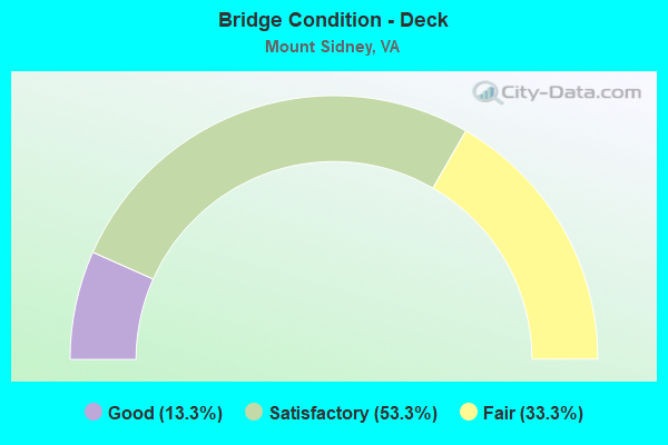
- Bridge Condition - Deck
- 13.3%Good
- 53.3%Satisfactory
- 33.3%Fair
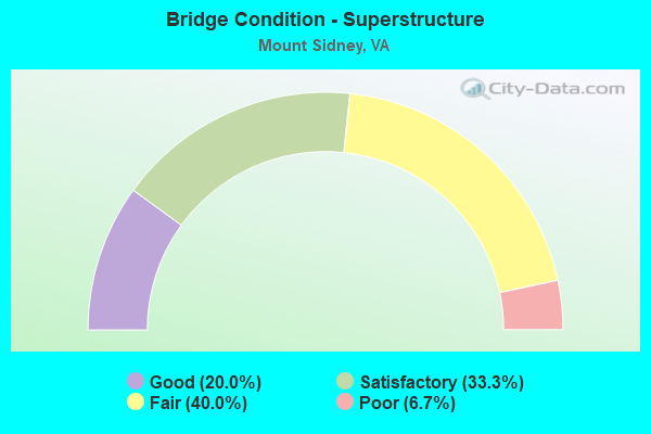
- Bridge Condition - Superstructure
- 20.0%Good
- 33.3%Satisfactory
- 40.0%Fair
- 6.7%Poor
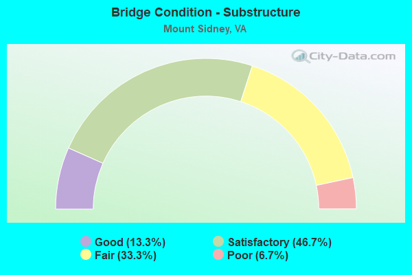
- Bridge Condition - Substructure
- 13.3%Good
- 46.7%Satisfactory
- 33.3%Fair
- 6.7%Poor
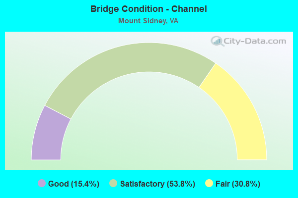
- Bridge Condition - Channel
- 15.4%Good
- 53.8%Satisfactory
- 30.8%Fair
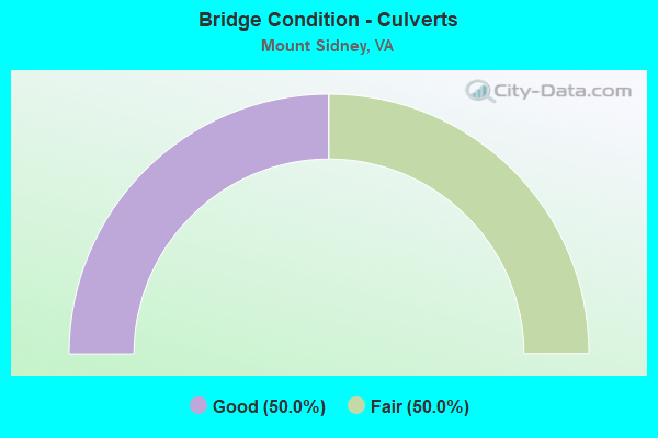
- Bridge Condition - Culverts
- 50.0%Good
- 50.0%Fair
Find on map >> Show street view
Structure Number: 51, Location: 00.05FR9TH/00.40TO0237 (Lat: 38.879528, Lng: -77.127944), Route carried "on" structure: County highway , Year Built: 1981, Status: Open, Structure Length: 6.95m (22.80ft), Average Daily Traffic: 10,500 (year 1987), Truck Traffic: 1%, Average Future Daily Traffic: 15,000 (year 2035), Design Load: HS 20, Features Intersected: CUSTIS MEM.PKWY (I-66), Facility Carried by Structure: NORTH HARRISON ST
Minimum Vertical Clearance: 30+ m (98+ ft), Kilometerpoint: 0.000, Lanes on structure: 2, Lanes under structure: 5, Owner: State Highway Agency, Approaching Roadway Width: 1.1m (3.6ft), Skew: 1 degrees, Material/Design: Steel continuous, Design/Construction: Stringer/Multi-beam, Number Of Spans In Main Unit: 2, Length of Maximum Span: 3.9m (12.8ft), Curb or Sidewalk Widths: Left: 1.5m (4.9ft), Right: 1.5m (4.9ft), Curb-To-Curb Width: 1.1m (3.6ft), Out-to-Out Width: 14.7m (48.2ft)
Condition: Deck: Satisfactory, Superstructure: Good, Substructure: Satisfactory, Operating Rating: 67.1 metric tons, Method Used To Determine Operating Rating: Load and Resistance Factor (LRFR), Inventory Rating: 51.7 metric tons, Method Used To Determine Inventory Rating: Load and Resistance Factor (LRFR), Structural Evaluation: Equal to present minimum criteria, Deck Geometry: Meets minimum limits, Underclear: Equal to present minimum criteria, Approach Roadway Alignment: Equal to present desirable criteria, Length Of Structure Improvement: 0.03m (0.10ft), Designated Inspection Frequency: Every 24 months, Inspection Date: August 2017, Bridge Improvement Cost: $1,000, Roadway Improvement Cost: $1,000, Total Project Cost: $3,000 ( Estimate for 2015), Deck Structure Type: Concrete Cast-file-Place, Wearing Surface/Protective System: Wearing Surface: Monolithic Concrete, Deck Protection: Epoxy Coated Reinforcing
Find on map >> Show street view
Structure Number: 507, Location: 2.67NELSON CL/3.41 TO 250 (Lat: 38.046631, Lng: -78.787506), Route carried "on" structure: Interstate 64, Year Built: 1974, Status: Open, Structure Length: 5.46m (17.91ft), Average Daily Traffic: 16,571 (year 2014), Truck Traffic: 10%, Average Future Daily Traffic: 19,320 (year 2035), Design Load: HS 20+Mod, Features Intersected: RTE 690 - NEWTOWN RD
Minimum Vertical Clearance: 30+ m (98+ ft), Kilometerpoint: 167.256, Lanes on structure: 2, Lanes under structure: 2, Base Highway Network: Yes, Owner: State Highway Agency, Approaching Roadway Width: 113.0m (370.7ft), Skew: 3 degrees, Material/Design: Steel, Design/Construction: Stringer/Multi-beam, Number Of Spans In Main Unit: 3, Length of Maximum Span: 20.1m (65.9ft), Curb-To-Curb Width: 11.8m (38.7ft), Out-to-Out Width: 1.3m (4.3ft)
Condition: Deck: Satisfactory, Superstructure: Satisfactory, Substructure: Fair, Inventory Rating: 87.1 metric tons, Method Used To Determine Inventory Rating: Load and Resistance Factor (LRFR), Structural Evaluation: Somewhat better than minimum adequacy, Deck Geometry: Equal to present minimum criteria, Underclear: Somewhat better than minimum adequacy, Approach Roadway Alignment: Equal to present desirable criteria, Length Of Structure Improvement: 54.60m (179.13ft), Designated Inspection Frequency: Every 24 months, Inspection Date: October 2016, Bridge Improvement Cost: $200,000, Roadway Improvement Cost: $10,000, Total Project Cost: $225,000, Deck Structure Type: Concrete Cast-file-Place, Wearing Surface/Protective System: Wearing Surface: Epoxy Overlay
Find on map >> Show street view
Structure Number: 2011, Location: 0.65 RT 777 - 1.63 RT 926 (Lat: 38.228756, Lng: -78.956950), Route carried "on" structure: County highway 616, Year Built: 1985, Status: Open, Structure Length: 0.67m (2.20ft), Average Daily Traffic: 900 (year 2014), Truck Traffic: 1%, Average Future Daily Traffic: 974 (year 2035), Design Load: H 20, Features Intersected: STREAM, Facility Carried by Structure: Damtown Rd
Minimum Vertical Clearance: 30+ m (98+ ft), Kilometerpoint: 9.187, Lanes on structure: 2, Owner: State Highway Agency, Approaching Roadway Width: 61.0m (200.1ft), Skew: 4 degrees, Material/Design: Aluminum, Iron, Design/Construction: Culvert, Number Of Spans In Main Unit: 2, Length of Maximum Span: 2.1m (6.9ft)
Condition: Channel: Satisfactory, Culverts: Good, Operating Rating: 44.5 metric tons, Method Used To Determine Operating Rating: Field evaluation and documented engineering judgment, Inventory Rating: 32.7 metric tons, Method Used To Determine Inventory Rating: Field evaluation and documented engineering judgment, Structural Evaluation: Better than present minimum criteria, Waterway Adequacy: Better than present minimum criteria, Approach Roadway Alignment: Equal to present desirable criteria, Designated Inspection Frequency: Every 24 months, Inspection Date: December 2017, Wearing Surface/Protective System: Wearing Surface: Bituminous
Find on map >> Show street view
Structure Number: 2015, Location: 0.14 RT 924 - 0.09 RT 777 (Lat: 38.236306, Lng: -78.966761), Route carried "under" structure: Interstate 81, Year Built: 1966, Structure Length: 0. m, Average Daily Traffic: 45,782 (year 2008), Truck Traffic: 12%, Features Intersected: RTE 81, Facility Carried by Structure: DAM TOWN RD.
Minimum Vertical Clearance: 5.26m (17.26ft), Kilometerpoint: 372.805, Lanes on structure: 2, Lanes under structure: 4, Material/Design: Prestressed concrete, Design/Construction: Stringer/Multi-beam, Length of Maximum Span: 21.3m (69.9ft)
Find on map >> Show street view
Structure Number: 224, Location: 0.20 TO 646 - 0.30 TO 804 (Lat: 38.300192, Lng: -78.983369), Route carried "on" structure: County highway 732, Year Built: 1932, Status: Open, Structure Length: 0.79m (2.59ft), Average Daily Traffic: 438 (year 2014), Truck Traffic: 3%, Average Future Daily Traffic: 820 (year 2035), Features Intersected: TRIB GOOSE CREEK, Facility Carried by Structure: ROMAN RD.
Minimum Vertical Clearance: 30+ m (98+ ft), Kilometerpoint: 19.018, Lanes on structure: 2, Owner: State Highway Agency, Approaching Roadway Width: 34.0m (111.5ft), Skew: 4 degrees, Material/Design: Concrete, Design/Construction: Slab, Number Of Spans In Main Unit: 1, Length of Maximum Span: 7.9m (25.9ft), Curb-To-Curb Width: 7.6m (24.9ft), Out-to-Out Width: 8.7m (28.5ft)
Condition: Deck: Fair, Superstructure: Fair, Substructure: Fair, Channel: Satisfactory, Operating Rating: 40.8 metric tons, Method Used To Determine Operating Rating: Field evaluation and documented engineering judgment, Inventory Rating: 24.5 metric tons, Method Used To Determine Inventory Rating: Field evaluation and documented engineering judgment, Structural Evaluation: Somewhat better than minimum adequacy, Deck Geometry: Meets minimum limits, Waterway Adequacy: Somewhat better than minimum adequacy, Approach Roadway Alignment: Meets minimum limits, Length Of Structure Improvement: 7.90m (25.92ft), Designated Inspection Frequency: Every 12 months, Inspection Date: May 2017, Bridge Improvement Cost: $19,000, Roadway Improvement Cost: $2,000, Total Project Cost: $21,000, Deck Structure Type: Concrete Cast-file-Place, Wearing Surface/Protective System: Wearing Surface: Bituminous
Find on map >> Show street view
Structure Number: 229, Location: 0.35 RT 752 1.45 RT 732 (Lat: 38.301244, Lng: -79.015131), Route carried "on" structure: County highway 753, Year Built: 1925, Status: Posted for load, Structure Length: 0.82m (2.69ft), Average Daily Traffic: 77 (year 2014), Average Future Daily Traffic: 101 (year 2035), Features Intersected: N FORK NAKED CREEK, Facility Carried by Structure: Slate Hill Rd
Minimum Vertical Clearance: 30+ m (98+ ft), Kilometerpoint: 7.208, Lanes on structure: 1, Owner: State Highway Agency, Approaching Roadway Width: 0.3m (1.0ft), Material/Design: Steel, Design/Construction: Stringer/Multi-beam, Number Of Spans In Main Unit: 1, Length of Maximum Span: 8.2m (26.9ft), Curb-To-Curb Width: 3.6m (11.8ft), Out-to-Out Width: 3.7m (12.1ft)
Condition: Deck: Satisfactory, Superstructure: Fair, Substructure: Fair, Channel: Satisfactory, Operating Rating: 15.4 metric tons, Method Used To Determine Operating Rating: Load and Resistance Factor (LRFR), Inventory Rating: 11.8 metric tons, Method Used To Determine Inventory Rating: Load and Resistance Factor (LRFR), Structural Evaluation: Meets minimum limits, Deck Geometry: High priority of corrective action, Waterway Adequacy: Equal to present minimum criteria, Approach Roadway Alignment: High priority of corrective action, Bridge Posting: Required (Relationship of Operating Rating to Maximum Legal Load: 30.0 - 39.9% below), Length Of Structure Improvement: 8.20m (26.90ft), Designated Inspection Frequency: Every 12 months, Inspection Date: July 2017, Bridge Improvement Cost: $67,000, Roadway Improvement Cost: $5,000, Total Project Cost: $101,000, Deck Structure Type: Wood or Timber, Wearing Surface/Protective System: Wearing Surface: Bituminous
Find on map >> Show street view
Structure Number: 2314, Location: 0.46 RT 11 - 0.09 RT 773 (Lat: 38.255186, Lng: -78.951211), Route carried "under" structure: Interstate 81, Year Built: 1966, Structure Length: 0. m, Average Daily Traffic: 45,782 (year 2008), Truck Traffic: 12%, Features Intersected: RTE 81, Facility Carried by Structure: Buttermilk Road
Minimum Vertical Clearance: 5.56m (18.24ft), Kilometerpoint: 375.283, Lanes on structure: 2, Lanes under structure: 4, Material/Design: Prestressed concrete, Design/Construction: Stringer/Multi-beam, Length of Maximum Span: 19.8m (65.0ft)
Find on map >> Show street view
Structure Number: 2353, Location: 1.07 RT 732 - 0.10 RT 746 (Lat: 38.282744, Lng: -78.986614), Route carried "on" structure: County highway 804, Year Built: 1926, Status: Open, Structure Length: 0.76m (2.49ft), Average Daily Traffic: 191 (year 2014), Truck Traffic: 2%, Average Future Daily Traffic: 270 (year 2035), Features Intersected: NAKED CREEK, Facility Carried by Structure: Salem Church Rd
Minimum Vertical Clearance: 30+ m (98+ ft), Kilometerpoint: 1.496, Lanes on structure: 2, Owner: State Highway Agency, Approaching Roadway Width: 55.0m (180.4ft), Skew: 4 degrees, Material/Design: Concrete, Design/Construction: Slab, Number Of Spans In Main Unit: 1, Length of Maximum Span: 7.6m (24.9ft), Curb-To-Curb Width: 6.6m (21.7ft), Out-to-Out Width: 7.1m (23.3ft)
Condition: Deck: Fair, Superstructure: Fair, Substructure: Satisfactory, Channel: Fair, Operating Rating: 39.9 metric tons, Method Used To Determine Operating Rating: Field evaluation and documented engineering judgment, Inventory Rating: 23.6 metric tons, Method Used To Determine Inventory Rating: Field evaluation and documented engineering judgment, Structural Evaluation: Somewhat better than minimum adequacy, Deck Geometry: Meets minimum limits, Waterway Adequacy: Equal to present minimum criteria, Approach Roadway Alignment: Somewhat better than minimum adequacy, Length Of Structure Improvement: 7.60m (24.93ft), Designated Inspection Frequency: Every 12 months, Inspection Date: September 2017, Bridge Improvement Cost: $25,000, Roadway Improvement Cost: $5,000, Total Project Cost: $30,000, Deck Structure Type: Concrete Cast-file-Place, Wearing Surface/Protective System: Wearing Surface: Bituminous
Find on map >> Show street view
Structure Number: 506, Location: .76 FR 608 & .82 TO 656 (Lat: 37.401264, Lng: -77.424572), Route carried "on" structure: Interstate 95, Year Built: 1958, Year Reconstructed: 1998, Status: Open, Structure Length: 2.29m (7.51ft), Average Daily Traffic: 100,600 (year 2014), Truck Traffic: 7%, Average Future Daily Traffic: 64,225 (year 2035), Design Load: HS 20+Mod, Features Intersected: RTE 613 (WILLIS RD)
Minimum Vertical Clearance: 30+ m (98+ ft), Kilometerpoint: 104.553, Lanes on structure: 6, Lanes under structure: 4, Base Highway Network: Yes, Owner: State Highway Agency, Approaching Roadway Width: 363.0m (1,190.9ft), Skew: 30 degrees, Material/Design: Steel, Design/Construction: Stringer/Multi-beam, Number Of Spans In Main Unit: 1, Length of Maximum Span: 22.9m (75.1ft), Curb-To-Curb Width: 36.2m (118.8ft), Out-to-Out Width: 37.8m (124.0ft)
Condition: Deck: Good, Superstructure: Good, Substructure: Satisfactory, Operating Rating: 79.8 metric tons, Method Used To Determine Operating Rating: Load and Resistance Factor (LRFR), Inventory Rating: 61.7 metric tons, Method Used To Determine Inventory Rating: Load and Resistance Factor (LRFR), Structural Evaluation: Equal to present minimum criteria, Deck Geometry: Superior to present desirable criteria, Underclear: Meets minimum limits, Approach Roadway Alignment: Equal to present desirable criteria, Designated Inspection Frequency: Every 24 months, Inspection Date: September 2016, Deck Structure Type: Concrete Cast-file-Place, Wearing Surface/Protective System: Deck Protection: Epoxy Coated Reinforcing
Find on map >> Show street view
Structure Number: 6021, Location: BRUNSWIK & DINWIDDIE LINE (Lat: 36.975267, Lng: -77.770686), Route carried "on" structure: County highway 610, Year Built: 1977, Status: Open, Structure Length: 6.78m (22.24ft), Average Daily Traffic: 251 (year 2014), Average Future Daily Traffic: 400 (year 2032), Design Load: HS 20+Mod, Features Intersected: NOTTOWAY RIVER, Facility Carried by Structure: BASKERVILLE MILL
Minimum Vertical Clearance: 30+ m (98+ ft), Kilometerpoint: 16.489, Lanes on structure: 2, Owner: State Highway Agency, Approaching Roadway Width: 67.0m (219.8ft), Material/Design: Steel, Design/Construction: Stringer/Multi-beam, Number Of Spans In Main Unit: 4, Length of Maximum Span: 2.1m (6.9ft), Curb-To-Curb Width: 7.9m (25.9ft), Out-to-Out Width: 9.1m (29.9ft)
Condition: Deck: Satisfactory, Superstructure: Satisfactory, Substructure: Satisfactory, Channel: Satisfactory, Operating Rating: 65.4 metric tons, Method Used To Determine Operating Rating: Load and Resistance Factor (LRFR), Inventory Rating: 50.4 metric tons, Method Used To Determine Inventory Rating: Load and Resistance Factor (LRFR), Structural Evaluation: Equal to present minimum criteria, Deck Geometry: Somewhat better than minimum adequacy, Waterway Adequacy: Better than present minimum criteria, Approach Roadway Alignment: Equal to present desirable criteria, Designated Inspection Frequency: Every 24 months, Underwater Inspection Frequency: Every 24 months, Inspection Date: May 2017, Underwater Inspection Date: May 2017, Deck Structure Type: Concrete Cast-file-Place
Find on map >> Show street view
Structure Number: 6022, Location: 1.33 Fr 627 & 2.11 To 645 (Lat: 37.093569, Lng: -77.608667), Route carried "on" structure: County highway 611, Year Built: 1964, Status: Posted for load, Structure Length: 0.91m (2.99ft), Average Daily Traffic: 552 (year 2014), Average Future Daily Traffic: 980 (year 2035), Features Intersected: CHAMBERLAINS BED CREEK, Facility Carried by Structure: WILKINSON ROAD
Minimum Vertical Clearance: 30+ m (98+ ft), Kilometerpoint: 2.148, Lanes on structure: 2, Owner: State Highway Agency, Approaching Roadway Width: 55.0m (180.4ft), Material/Design: Wood or Timber, Design/Construction: Stringer/Multi-beam, Number Of Spans In Main Unit: 2, Length of Maximum Span: 4.9m (16.1ft), Curb-To-Curb Width: 5.8m (19.0ft), Out-to-Out Width: 0.7m (2.3ft)
Condition: Deck: Fair, Superstructure: Fair, Substructure: Poor, Channel: Fair, Operating Rating: 9.1 metric tons, Method Used To Determine Operating Rating: Field evaluation and documented engineering judgment, Inventory Rating: 4.5 metric tons, Method Used To Determine Inventory Rating: Field evaluation and documented engineering judgment, Structural Evaluation: High priority of corrective action, Deck Geometry: High priority of replacement, Waterway Adequacy: Somewhat better than minimum adequacy, Approach Roadway Alignment: Equal to present minimum criteria, Bridge Posting: Required (Relationship of Operating Rating to Maximum Legal Load: 0.1 - 9.9% below), Length Of Structure Improvement: 9.10m (29.86ft), Designated Inspection Frequency: Every 12 months, Underwater Inspection Frequency: Every 12 months, Inspection Date: January 2018, Underwater Inspection Date: October 2017, Bridge Improvement Cost: $125,000, Roadway Improvement Cost: $50,000, Total Project Cost: $201,000, Deck Structure Type: Wood or Timber, Wearing Surface/Protective System: Wearing Surface: Bituminous
Find on map >> Show street view
Structure Number: 7112, Location: 1.35 Fr 17 & .85 To 605 (Lat: 38.729042, Lng: -77.777950), Route carried "on" structure: US 15, Year Built: 1986, Status: Open, Structure Length: 2.56m (8.40ft), Average Daily Traffic: 22,822 (year 2014), Truck Traffic: 8%, Average Future Daily Traffic: 57,900 (year 2035), Design Load: HS 20, Features Intersected: Cedar Run
Minimum Vertical Clearance: 30+ m (98+ ft), Kilometerpoint: 298.019, Lanes on structure: 2, Base Highway Network: Yes, Owner: State Highway Agency, Approaching Roadway Width: 73.0m (239.5ft), Material/Design: Concrete, Design/Construction: Slab, Number Of Spans In Main Unit: 4, Length of Maximum Span: 6.7m (22.0ft), Curb-To-Curb Width: 11.7m (38.4ft), Out-to-Out Width: 12.7m (41.7ft)
Condition: Deck: Satisfactory, Superstructure: Satisfactory, Substructure: Satisfactory, Channel: Satisfactory, Inventory Rating: 60.8 metric tons, Method Used To Determine Inventory Rating: Load Factor (LF), Structural Evaluation: Equal to present minimum criteria, Deck Geometry: Equal to present minimum criteria, Waterway Adequacy: Superior to present desirable criteria, Approach Roadway Alignment: Equal to present desirable criteria, Designated Inspection Frequency: Every 24 months, Inspection Date: September 2017, Deck Structure Type: Concrete Precast Panels, Wearing Surface/Protective System: Wearing Surface: Bituminous, Deck Protection: Epoxy Coated Reinforcing
Find on map >> Show street view
Structure Number: 8995, Location: .01 From 630S&.01 To 630N (Lat: 38.283583, Lng: -78.519669), Route carried "on" structure: County highway 631, Year Built: 1932, Year Reconstructed: 1987, Status: Open, Structure Length: 0.91m (2.99ft), Average Daily Traffic: 335 (year 2014), Average Future Daily Traffic: 441 (year 2035), Features Intersected: Haneytown Creek, Facility Carried by Structure: Haneytown Road
Minimum Vertical Clearance: 30+ m (98+ ft), Kilometerpoint: 2.422, Lanes on structure: 2, Owner: State Highway Agency, Approaching Roadway Width: 55.0m (180.4ft), Material/Design: Steel, Design/Construction: Stringer/Multi-beam, Number Of Spans In Main Unit: 1, Length of Maximum Span: 9.1m (29.9ft), Curb or Sidewalk Widths: Left: 0.2m (0.7ft), Right: 0.2m (0.7ft), Curb-To-Curb Width: 5.4m (17.7ft), Out-to-Out Width: 5.5m (18.0ft)
Condition: Deck: Fair, Superstructure: Poor, Substructure: Fair, Channel: Satisfactory, Operating Rating: 38.1 metric tons, Method Used To Determine Operating Rating: Allowable Stress (AS), Inventory Rating: 26.3 metric tons, Method Used To Determine Inventory Rating: Allowable Stress (AS), Structural Evaluation: Meets minimum limits, Deck Geometry: High priority of replacement, Waterway Adequacy: Equal to present minimum criteria, Approach Roadway Alignment: High priority of corrective action, Length Of Structure Improvement: 10.70m (35.10ft), Designated Inspection Frequency: Every 12 months, Inspection Date: June 2017, Bridge Improvement Cost: $125,000, Roadway Improvement Cost: $20,000, Total Project Cost: $160,000 ( Estimate for 2013), Deck Structure Type: Wood or Timber
Find on map >> Show street view
Structure Number: 1745, Location: EXIT 47 (MILE 47.75) (Lat: 36.849958, Lng: -81.484089), Route carried "on" structure: Interstate 81, Year Built: 1963, Status: Open, Structure Length: 3.84m (12.60ft), Average Daily Traffic: 13,556 (year 2014), Truck Traffic: 20%, Average Future Daily Traffic: 17,541 (year 2035), Design Load: HS 20+Mod, Features Intersected: RTE F010 FROM RTE 11
Minimum Vertical Clearance: 30+ m (98+ ft), Kilometerpoint: 77.232, Lanes on structure: 2, Lanes under structure: 2, Base Highway Network: Yes, Owner: State Highway Agency, Approaching Roadway Width: 149.0m (488.8ft), Material/Design: Steel, Design/Construction: Stringer/Multi-beam, Number Of Spans In Main Unit: 3, Length of Maximum Span: 38.4m (126.0ft), Curb-To-Curb Width: 12.8m (42.0ft), Out-to-Out Width: 13.7m (44.9ft)
Condition: Deck: Satisfactory, Superstructure: Fair, Substructure: Good, Operating Rating: 67.1 metric tons, Method Used To Determine Operating Rating: Load and Resistance Factor (LRFR), Inventory Rating: 50.8 metric tons, Method Used To Determine Inventory Rating: Load and Resistance Factor (LRFR), Structural Evaluation: Somewhat better than minimum adequacy, Deck Geometry: Equal to present desirable criteria, Underclear: Meets minimum limits, Approach Roadway Alignment: Better than present minimum criteria, Length Of Structure Improvement: 38.40m (125.98ft), Designated Inspection Frequency: Every 24 months, Inspection Date: January 2018, Bridge Improvement Cost: $428,000, Roadway Improvement Cost: $25,000, Total Project Cost: $589,000 ( Estimate for 2014), Deck Structure Type: Concrete Cast-file-Place, Wearing Surface/Protective System: Deck Protection: Epoxy Coated Reinforcing
Find on map >> Show street view
Structure Number: 19438, Location: .15M TO 58A&.45M TO 658 (Lat: 36.903169, Lng: -82.374586), Route carried "on" structure: County highway 657, Year Built: 1938, Status: Open, Structure Length: 0.11m (0.36ft), Average Daily Traffic: 472 (year 2014), Average Future Daily Traffic: 621 (year 2035), Design Load: HS 20+Mod, Features Intersected: BULL RUN CREEK, Facility Carried by Structure: CARFAX RD
Minimum Vertical Clearance: 30+ m (98+ ft), Kilometerpoint: 3.192, Lanes on structure: 2, Owner: State Highway Agency, Approaching Roadway Width: 61.0m (200.1ft), Material/Design: Concrete, Design/Construction: Slab, Number Of Spans In Main Unit: 1, Length of Maximum Span: 1.1m (3.6ft), Curb or Sidewalk Widths: Left: 0.3m (1.0ft), Right: 0.3m (1.0ft), Curb-To-Curb Width: 7.3m (24.0ft), Out-to-Out Width: 7.9m (25.9ft)
Condition: Deck: Satisfactory, Superstructure: Satisfactory, Substructure: Satisfactory, Channel: Fair, Inventory Rating: 69.9 metric tons, Method Used To Determine Inventory Rating: Load and Resistance Factor (LRFR), Structural Evaluation: Equal to present minimum criteria, Deck Geometry: Meets minimum limits, Waterway Adequacy: Better than present minimum criteria, Approach Roadway Alignment: Better than present minimum criteria, Designated Inspection Frequency: Every 24 months, Inspection Date: December 2017, Deck Structure Type: Concrete Cast-file-Place
Find on map >> Show street view
Structure Number: 1944, Location: 1.51MTO1125&.25MTO709 (Lat: 36.935686, Lng: -82.486778), Route carried "on" structure: County highway 658, Year Built: 1983, Status: Open, Structure Length: 4.02m (13.19ft), Average Daily Traffic: 1,335 (year 2014), Average Future Daily Traffic: 2,201 (year 2035), Design Load: HS 20+Mod, Features Intersected: GUEST RIVER #4, Facility Carried by Structure: RIVERVIEW ROAD
Minimum Vertical Clearance: 30+ m (98+ ft), Kilometerpoint: 0.925, Lanes on structure: 2, Owner: State Highway Agency, Approaching Roadway Width: 79.0m (259.2ft), Skew: 2 degrees, Material/Design: Concrete continuous, Design/Construction: Slab, Number Of Spans In Main Unit: 3, Length of Maximum Span: 15.2m (49.9ft), Curb or Sidewalk Widths: Left: 0.2m (0.7ft), Right: 0.2m (0.7ft), Curb-To-Curb Width: 9.4m (30.8ft), Out-to-Out Width: 10.4m (34.1ft)
Condition: Deck: Satisfactory, Superstructure: Satisfactory, Substructure: Satisfactory, Channel: Good, Operating Rating: 86.2 metric tons, Method Used To Determine Operating Rating: Load and Resistance Factor (LRFR), Inventory Rating: 53.5 metric tons, Method Used To Determine Inventory Rating: Load and Resistance Factor (LRFR), Structural Evaluation: Equal to present minimum criteria, Deck Geometry: Somewhat better than minimum adequacy, Waterway Adequacy: Equal to present desirable criteria, Approach Roadway Alignment: Equal to present desirable criteria, Designated Inspection Frequency: Every 24 months, Inspection Date: July 2016, Deck Structure Type: Concrete Cast-file-Place
Find on map >> Show street view
Structure Number: 19442, Location: .15M TO 1129&.13MTO1117 (Lat: 36.936133, Lng: -82.474981), Route carried "on" structure: County highway 658, Year Built: 1967, Status: Open, Structure Length: 2.99m (9.81ft), Average Daily Traffic: 2,040 (year 2014), Average Future Daily Traffic: 4,101 (year 2035), Features Intersected: GUEST RIVER, Facility Carried by Structure: CENTRAL STREET
Minimum Vertical Clearance: 30+ m (98+ ft), Kilometerpoint: 2.159, Lanes on structure: 2, Owner: State Highway Agency, Approaching Roadway Width: 79.0m (259.2ft), Skew: 3 degrees, Material/Design: Steel, Design/Construction: Stringer/Multi-beam, Number Of Spans In Main Unit: 2, Length of Maximum Span: 14.9m (48.9ft), Curb or Sidewalk Widths: Left: 0.3m (1.0ft), Right: 1.5m (4.9ft), Curb-To-Curb Width: 7.9m (25.9ft), Out-to-Out Width: 10.2m (33.5ft)
Condition: Deck: Fair, Superstructure: Fair, Substructure: Fair, Channel: Satisfactory, Operating Rating: 70.8 metric tons, Method Used To Determine Operating Rating: Load Factor (LF), Inventory Rating: 41.7 metric tons, Method Used To Determine Inventory Rating: Load Factor (LF), Structural Evaluation: Somewhat better than minimum adequacy, Deck Geometry: High priority of corrective action, Waterway Adequacy: Better than present minimum criteria, Approach Roadway Alignment: Better than present minimum criteria, Length Of Structure Improvement: 29.90m (98.10ft), Designated Inspection Frequency: Every 24 months, Inspection Date: July 2016, Bridge Improvement Cost: $206,000, Roadway Improvement Cost: $20,000, Total Project Cost: $294,000 ( Estimate for 2015), Deck Structure Type: Concrete Cast-file-Place
Find on map >> Show street view
Structure Number: 23515, Location: 0.12 RT 752 - 0.79 RT 732 (Lat: 38.314631, Lng: -78.987086), Route carried "on" structure: County highway 646, Year Built: 1992, Status: Open, Structure Length: 1.04m (3.41ft), Average Daily Traffic: 735 (year 2014), Truck Traffic: 2%, Average Future Daily Traffic: 1,099 (year 2035), Design Load: HS 20, Features Intersected: TRIB N FORK NAKED CREEK, Facility Carried by Structure: Fadley Road
Minimum Vertical Clearance: 30+ m (98+ ft), Kilometerpoint: 0.066, Lanes on structure: 2, Owner: State Highway Agency, Approaching Roadway Width: 67.0m (219.8ft), Material/Design: Concrete, Design/Construction: Culvert, Number Of Spans In Main Unit: 3, Length of Maximum Span: 0.3m (1.0ft)
Condition: Channel: Fair, Culverts: Fair, Operating Rating: 44.5 metric tons, Method Used To Determine Operating Rating: Field evaluation and documented engineering judgment, Inventory Rating: 32.7 metric tons, Method Used To Determine Inventory Rating: Field evaluation and documented engineering judgment, Structural Evaluation: Somewhat better than minimum adequacy, Waterway Adequacy: Equal to present minimum criteria, Approach Roadway Alignment: Equal to present desirable criteria, Designated Inspection Frequency: Every 24 months, Inspection Date: September 2016
Find on map >> Show street view
Structure Number: 2631, Location: 0.73 RT 680 0.36 RT 646 (Lat: 38.308750, Lng: -78.969058), Route carried "on" structure: County highway 696, Year Built: 1999, Status: Open, Structure Length: 1.22m (4.00ft), Average Daily Traffic: 73 (year 2014), Average Future Daily Traffic: 96 (year 2035), Design Load: HS 20+Mod, Features Intersected: NORTH FORK NAKED CREEK, Facility Carried by Structure: Coffman Rd
Minimum Vertical Clearance: 30+ m (98+ ft), Kilometerpoint: 6.613, Lanes on structure: 2, Owner: State Highway Agency, Approaching Roadway Width: 61.0m (200.1ft), Material/Design: Prestressed concrete, Design/Construction: Stringer/Multi-beam, Number Of Spans In Main Unit: 1, Length of Maximum Span: 12.2m (40.0ft), Curb-To-Curb Width: 7.8m (25.6ft), Out-to-Out Width: 8.5m (27.9ft)
Condition: Deck: Good, Superstructure: Good, Substructure: Good, Channel: Good, Operating Rating: 68.9 metric tons, Method Used To Determine Operating Rating: Load and Resistance Factor (LRFR), Inventory Rating: 52.6 metric tons, Method Used To Determine Inventory Rating: Load and Resistance Factor (LRFR), Structural Evaluation: Better than present minimum criteria, Deck Geometry: Equal to present minimum criteria, Waterway Adequacy: Equal to present minimum criteria, Approach Roadway Alignment: Equal to present desirable criteria, Designated Inspection Frequency: Every 24 months, Inspection Date: Febuary 2018, Deck Structure Type: Concrete Precast Panels, Wearing Surface/Protective System: Wearing Surface: Epoxy Overlay, Membrane: Preformed Fabric, Deck Protection: Epoxy Coated Reinforcing