Bridge Statistics for Mountlake Terrace, Washington (WA)
Condition, Traffic, Stress, Structural Evaluation, Project Costs
- National Bridge Inventory (NBI) Statistics
- 14Number of bridges
- 226ft / 69.3mTotal length
- $47,587,000Total costs
- 881,682Total average daily traffic
- 45,050Total average daily truck traffic
- National Bridge Inventory (NBI) Registered Bridges for Mountlake Terrace
- No street view available for this location
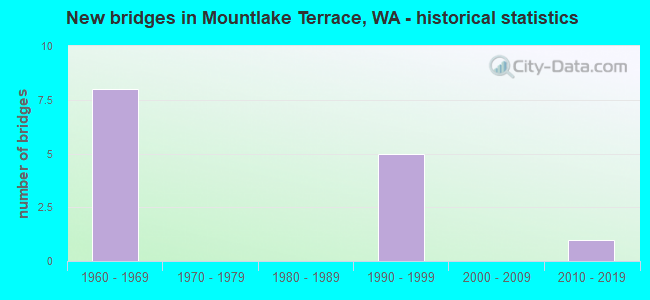
- New bridges - historical statistics
- 81960-1969
- 51990-1999
- 12010-2019
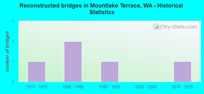
- Reconstructed bridges - Historical Statistics
- 11970-1979
- 21980-1989
- 11990-1999
- 02000-2009
- 12010-2019
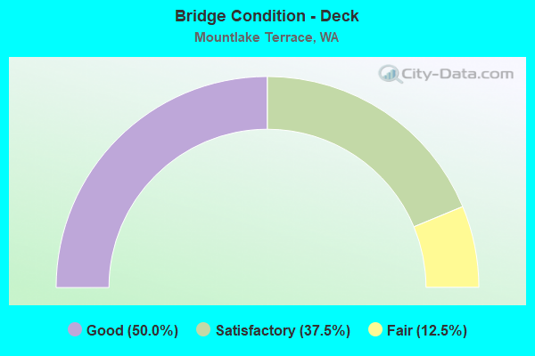
- Bridge Condition - Deck
- 50.0%Good
- 37.5%Satisfactory
- 12.5%Fair
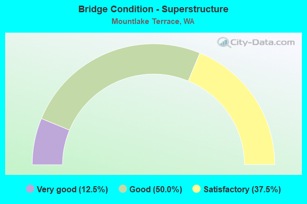
- Bridge Condition - Superstructure
- 12.5%Very good
- 50.0%Good
- 37.5%Satisfactory
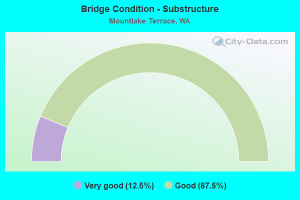
- Bridge Condition - Substructure
- 12.5%Very good
- 87.5%Good
Find on map >> Show street view
Structure Number: 7071D, Location: 1.0 N JCT SR 104 (Lat: 47.791856, Lng: -122.316781), Route carried "on" structure: City street , Year Built: 1963, Status: Open, Structure Length: 10.30m (33.79ft), Average Daily Traffic: 2,919 (year 2020), Truck Traffic: 5%, Average Future Daily Traffic: 4,691 (year 2040), Design Load: HS 20, Features Intersected: I-5, RAMPS, Facility Carried by Structure: 228TH ST SW
Minimum Vertical Clearance: 30+ m (98+ ft), Kilometerpoint: 1.545, Lanes on structure: 2, Lanes under structure: 10, Owner: State Highway Agency, Approaching Roadway Width: 9.1m (29.9ft), Skew: 9 degrees, Material/Design: Prestressed concrete, Design/Construction: Stringer/Multi-beam, Number Of Spans In Main Unit: 5, Length of Maximum Span: 24.1m (79.1ft), Curb or Sidewalk Widths: Left: 0.6m (2.0ft), Right: 1.5m (4.9ft), Curb-To-Curb Width: 9.1m (29.9ft), Out-to-Out Width: 11.6m (38.1ft)
Condition: Deck: Good, Superstructure: Good, Substructure: Good, Operating Rating: 61.7 metric tons, Method Used To Determine Operating Rating: Load Factor (LF), Inventory Rating: 36.3 metric tons, Method Used To Determine Inventory Rating: Load Factor (LF), Structural Evaluation: Better than present minimum criteria, Deck Geometry: Meets minimum limits, Underclear: High priority of corrective action, Approach Roadway Alignment: Equal to present desirable criteria, Length Of Structure Improvement: 10.30m (33.79ft), Designated Inspection Frequency: Every 24 months, Inspection Date: July 2021, Bridge Improvement Cost: $2,163,000, Roadway Improvement Cost: $433,000, Total Project Cost: $4,326,000 ( Estimate for 2014), Deck Structure Type: Concrete Cast-file-Place, Wearing Surface/Protective System: Wearing Surface: Monolithic Concrete
Find on map >> Show street view
Structure Number: 7071F, Location: 2.2 N JCT SR 104 (Lat: 47.806333, Lng: -122.306917), Route carried "on" structure: Interstate 5, Year Built: 1963, Year Reconstructed: 1993, Status: Open, Structure Length: 8.47m (27.79ft), Average Daily Traffic: 104,565 (year 2019), Truck Traffic: 5%, Average Future Daily Traffic: 151,410 (year 2039), Design Load: HS 20, Features Intersected: 212TH ST SW
Minimum Vertical Clearance: 30+ m (98+ ft), Kilometerpoint: 289.505, Lanes on structure: 4, Lanes under structure: 2, Base Highway Network: Yes, Owner: State Highway Agency, Approaching Roadway Width: 20.7m (67.9ft), Skew: 5 degrees, Material/Design: Prestressed concrete, Design/Construction: Stringer/Multi-beam, Number Of Spans In Main Unit: 3, Length of Maximum Span: 32.6m (107.0ft), Curb-To-Curb Width: 20.7m (67.9ft), Out-to-Out Width: 21.6m (70.9ft)
Condition: Deck: Satisfactory, Superstructure: Satisfactory, Substructure: Good, Operating Rating: 36.3 metric tons, Method Used To Determine Operating Rating: Load Factor (LF), Inventory Rating: 21.8 metric tons, Method Used To Determine Inventory Rating: Load Factor (LF), Structural Evaluation: Somewhat better than minimum adequacy, Deck Geometry: Equal to present minimum criteria, Underclear: Superior to present desirable criteria, Approach Roadway Alignment: Equal to present desirable criteria, Length Of Structure Improvement: 8.47m (27.79ft), Designated Inspection Frequency: Every 24 months, Inspection Date: Febuary 2020, Bridge Improvement Cost: $3,892,000, Roadway Improvement Cost: $778,000, Total Project Cost: $7,784,000 ( Estimate for 2014), Deck Structure Type: Concrete Cast-file-Place, Wearing Surface/Protective System: Wearing Surface: Integral Concrete
Find on map >> Show street view
Structure Number: 7071G, Location: 2.2 N JCT SR 104 (Lat: 47.806333, Lng: -122.306167), Route carried "on" structure: Interstate 5, Year Built: 1963, Year Reconstructed: 1995, Status: Open, Structure Length: 8.47m (27.79ft), Average Daily Traffic: 104,565 (year 2019), Truck Traffic: 5%, Average Future Daily Traffic: 151,410 (year 2039), Design Load: HS 20, Features Intersected: 212TH ST SW
Minimum Vertical Clearance: 30+ m (98+ ft), Kilometerpoint: 289.537, Lanes on structure: 5, Lanes under structure: 2, Base Highway Network: Yes, Owner: State Highway Agency, Approaching Roadway Width: 20.7m (67.9ft), Skew: 5 degrees, Material/Design: Prestressed concrete, Design/Construction: Stringer/Multi-beam, Number Of Spans In Main Unit: 3, Length of Maximum Span: 32.6m (107.0ft), Curb-To-Curb Width: 20.7m (67.9ft), Out-to-Out Width: 21.6m (70.9ft)
Condition: Deck: Satisfactory, Superstructure: Satisfactory, Substructure: Good, Operating Rating: 18.8 metric tons, Method Used To Determine Operating Rating: Load and Resistance Factor Rating (LRFR) rating reported by rating factor(RF) method using HL-93 loadings, Inventory Rating: 14.6 metric tons, Method Used To Determine Inventory Rating: Load and Resistance Factor Rating (LRFR) rating reported by rating factor(RF) method using HL-93 loadings, Structural Evaluation: High priority of corrective action, Deck Geometry: Meets minimum limits, Underclear: Superior to present desirable criteria, Approach Roadway Alignment: Equal to present desirable criteria, Length Of Structure Improvement: 8.47m (27.79ft), Designated Inspection Frequency: Every 24 months, Inspection Date: Febuary 2020, Bridge Improvement Cost: $3,892,000, Roadway Improvement Cost: $778,000, Total Project Cost: $7,784,000 ( Estimate for 2014), Deck Structure Type: Concrete Cast-file-Place, Wearing Surface/Protective System: Wearing Surface: Integral Concrete
Find on map >> Show street view
Structure Number: 7227A, Location: 0.4 N JCT SR 104 (Lat: 47.784889, Lng: -122.317028), Route carried "on" structure: City street , Year Built: 1963, Year Reconstructed: 1983, Status: Open, Structure Length: 9.72m (31.89ft), Average Daily Traffic: 9,426 (year 2020), Truck Traffic: 5%, Average Future Daily Traffic: 15,147 (year 2040), Design Load: HS 20, Features Intersected: I-5, Facility Carried by Structure: 236TH ST SW
Minimum Vertical Clearance: 30+ m (98+ ft), Kilometerpoint: 0.064, Lanes on structure: 4, Lanes under structure: 13, Owner: State Highway Agency, Approaching Roadway Width: 14.6m (47.9ft), Material/Design: Prestressed concrete, Design/Construction: Stringer/Multi-beam, Number Of Spans In Main Unit: 4, Length of Maximum Span: 27.4m (89.9ft), Curb or Sidewalk Widths: Left: 2.4m (7.9ft), Right: 0.0m, Curb-To-Curb Width: 14.6m (47.9ft), Out-to-Out Width: 17.9m (58.7ft)
Condition: Deck: Good, Superstructure: Good, Substructure: Good, Operating Rating: 30.5 metric tons, Method Used To Determine Operating Rating: Load and Resistance Factor Rating (LRFR) rating reported by rating factor(RF) method using HL-93 loadings, Inventory Rating: 23.3 metric tons, Method Used To Determine Inventory Rating: Load and Resistance Factor Rating (LRFR) rating reported by rating factor(RF) method using HL-93 loadings, Structural Evaluation: Somewhat better than minimum adequacy, Deck Geometry: High priority of replacement, Underclear: High priority of corrective action, Approach Roadway Alignment: Equal to present desirable criteria, Length Of Structure Improvement: 9.72m (31.89ft), Designated Inspection Frequency: Every 24 months, Inspection Date: August 2021, Bridge Improvement Cost: $3,190,000, Roadway Improvement Cost: $638,000, Total Project Cost: $6,380,000 ( Estimate for 2014), Deck Structure Type: Concrete Cast-file-Place, Wearing Surface/Protective System: Wearing Surface: Bituminous, Membrane: Preformed Fabric
Find on map >> Show street view
Structure Number: 12790A, Location: 1.5 N JCT SR 104 (Lat: 47.799500, Lng: -122.315278), Route carried "on" structure: County highway , Year Built: 1963, Year Reconstructed: 1985, Status: Open, Structure Length: 10.30m (33.79ft), Average Daily Traffic: 25,227 (year 2010), Truck Traffic: 5%, Average Future Daily Traffic: 40,969 (year 2036), Design Load: HS 20, Features Intersected: I-5, Facility Carried by Structure: 220TH ST SW
Minimum Vertical Clearance: 30+ m (98+ ft), Kilometerpoint: 0.080, Lanes on structure: 6, Lanes under structure: 8, Owner: State Highway Agency, Approaching Roadway Width: 21.9m (71.9ft), Material/Design: Prestressed concrete, Design/Construction: Stringer/Multi-beam, Number Of Spans In Main Unit: 4, Length of Maximum Span: 30.5m (100.1ft), Curb or Sidewalk Widths: Left: 0.0m, Right: 3.0m (9.8ft), Curb-To-Curb Width: 21.9m (71.9ft), Out-to-Out Width: 26.0m (85.3ft)
Condition: Deck: Satisfactory, Superstructure: Satisfactory, Substructure: Good, Operating Rating: 23.7 metric tons, Method Used To Determine Operating Rating: Load and Resistance Factor Rating (LRFR) rating reported by rating factor(RF) method using HL-93 loadings, Inventory Rating: 18.5 metric tons, Method Used To Determine Inventory Rating: Load and Resistance Factor Rating (LRFR) rating reported by rating factor(RF) method using HL-93 loadings, Structural Evaluation: Meets minimum limits, Deck Geometry: High priority of corrective action, Underclear: High priority of corrective action, Approach Roadway Alignment: Equal to present desirable criteria, Length Of Structure Improvement: 10.30m (33.79ft), Designated Inspection Frequency: Every 48 months, Inspection Date: October 2018, Bridge Improvement Cost: $5,002,000, Roadway Improvement Cost: $1,000,000, Total Project Cost: $10,005,000 ( Estimate for 2014), Deck Structure Type: Concrete Cast-file-Place, Wearing Surface/Protective System: Wearing Surface: Latex Concrete
Find on map >> Show street view
Structure Number: 14326A, Location: 3.2 N JCT SR 523 (Lat: 47.782722, Lng: -122.316194), Route carried "on" structure: Ramp Interstate 5, Year Built: 1995, Status: Open, Structure Length: 11.67m (38.29ft), Average Daily Traffic: 4,201 (year 2019), Truck Traffic: 5%, Average Future Daily Traffic: 6,083 (year 2039), Design Load: HS 25 or greater, Features Intersected: NBCD
Minimum Vertical Clearance: 30+ m (98+ ft), Kilometerpoint: 0.290, Lanes on structure: 1, Lanes under structure: 2, Owner: State Highway Agency, Approaching Roadway Width: 9.1m (29.9ft), Material/Design: Prestressed concrete continuous, Design/Construction: Box Beam or Girders - Multiple, Number Of Spans In Main Unit: 3, Length of Maximum Span: 50.6m (166.0ft), Curb-To-Curb Width: 9.1m (29.9ft), Out-to-Out Width: 9.8m (32.2ft)
Condition: Deck: Good, Superstructure: Good, Substructure: Good, Operating Rating: 89.8 metric tons, Method Used To Determine Operating Rating: Load Factor (LF), Inventory Rating: 89.8 metric tons, Method Used To Determine Inventory Rating: Load Factor (LF), Structural Evaluation: Better than present minimum criteria, Deck Geometry: Superior to present desirable criteria, Underclear: Better than present minimum criteria, Approach Roadway Alignment: Equal to present desirable criteria, Length Of Structure Improvement: 11.67m (38.29ft), Designated Inspection Frequency: Every 24 months, Inspection Date: Febuary 2020, Bridge Improvement Cost: $2,451,000, Roadway Improvement Cost: $490,000, Total Project Cost: $4,902,000 ( Estimate for 2014), Deck Structure Type: Concrete Cast-file-Place, Wearing Surface/Protective System: Wearing Surface: Monolithic Concrete, Deck Protection: Epoxy Coated Reinforcing
Find on map >> Show street view
Structure Number: 14326B, Location: 3.2 N JCT SR 523 (Lat: 47.784000, Lng: -122.317444), Route carried "on" structure: Ramp Interstate 5, Year Built: 1995, Status: Open, Structure Length: 9.39m (30.81ft), Average Daily Traffic: 7,005 (year 2019), Truck Traffic: 5%, Average Future Daily Traffic: 10,143 (year 2039), Design Load: HS 25 or greater, Features Intersected: S-E RAMP, Facility Carried by Structure: S-S RAMP
Minimum Vertical Clearance: 30+ m (98+ ft), Kilometerpoint: 0.097, Lanes on structure: 2, Lanes under structure: 1, Owner: State Highway Agency, Approaching Roadway Width: 15.2m (49.9ft), Material/Design: Prestressed concrete continuous, Design/Construction: Box Beam or Girders - Multiple, Number Of Spans In Main Unit: 3, Length of Maximum Span: 40.2m (131.9ft), Curb-To-Curb Width: 12.8m (42.0ft), Out-to-Out Width: 13.7m (44.9ft)
Condition: Deck: Good, Superstructure: Good, Substructure: Good, Operating Rating: 89.8 metric tons, Method Used To Determine Operating Rating: Load Factor (LF), Inventory Rating: 89.8 metric tons, Method Used To Determine Inventory Rating: Load Factor (LF), Structural Evaluation: Better than present minimum criteria, Deck Geometry: Superior to present desirable criteria, Underclear: Somewhat better than minimum adequacy, Approach Roadway Alignment: Equal to present desirable criteria, Length Of Structure Improvement: 9.39m (30.81ft), Designated Inspection Frequency: Every 48 months, Inspection Date: October 2018, Bridge Improvement Cost: $3,203,000, Roadway Improvement Cost: $641,000, Total Project Cost: $6,406,000 ( Estimate for 2014), Deck Structure Type: Concrete Cast-file-Place, Wearing Surface/Protective System: Wearing Surface: Monolithic Concrete, Deck Protection: Epoxy Coated Reinforcing
Find on map >> Show street view
Structure Number: 8913, Location: 0.2 NW 244TH ST SW (Lat: 47.780000, Lng: -122.314333), Route carried "on" structure: City street 815, Year Built: 1990, Year Reconstructed: 2018, Status: Posted for load, Structure Length: 0.98m (3.22ft), Average Daily Traffic: 1,000 (year 2020), Truck Traffic: 2%, Average Future Daily Traffic: 8,500 (year 2040), Design Load: HL 93, Features Intersected: MCALEER CREEK, Facility Carried by Structure: VAN RY BLVD
Minimum Vertical Clearance: 30+ m (98+ ft), Kilometerpoint: 0.001, Lanes on structure: 2, Owner: City or Municipal Highway Agency, Approaching Roadway Width: 11.0m (36.1ft), Skew: 24 degrees, Material/Design: Concrete, Design/Construction: Tee Beam, Number Of Spans In Main Unit: 1, Length of Maximum Span: 9.1m (29.9ft), Curb or Sidewalk Widths: Left: 2.0m (6.6ft), Right: 1.1m (3.6ft), Curb-To-Curb Width: 11.0m (36.1ft), Out-to-Out Width: 14.0m (45.9ft)
Condition: Deck: Fair, Superstructure: Very good, Substructure: Very good, Channel: Very good, Operating Rating: 32.7 metric tons, Method Used To Determine Operating Rating: Load Factor (LF), Inventory Rating: 29.0 metric tons, Method Used To Determine Inventory Rating: Load Factor (LF), Structural Evaluation: Better than present minimum criteria, Deck Geometry: Better than present minimum criteria, Waterway Adequacy: Equal to present desirable criteria, Approach Roadway Alignment: Equal to present desirable criteria, Designated Inspection Frequency: Every 24 months, Inspection Date: Febuary 2021, Deck Structure Type: Concrete Cast-file-Place
Find on map >> Show street view
Structure Number: 7071D, Location: 1.0 N JCT SR 104 (Lat: 47.791856, Lng: -122.316781), Route carried "under" structure: Interstate 5, Year Built: 1963, Structure Length: 0. m, Average Daily Traffic: 184,437 (year 2019), Truck Traffic: 5%, Features Intersected: I-5, RAMPS, Facility Carried by Structure: 228TH ST SW
Minimum Vertical Clearance: 7.19m (23.59ft), Kilometerpoint: 287.654, Lanes on structure: 2, Lanes under structure: 8, Material/Design: Prestressed concrete, Design/Construction: Stringer/Multi-beam, Length of Maximum Span: 24.1m (79.1ft)
Find on map >> Show street view
Structure Number: 7227A, Location: 0.4 N JCT SR 104 (Lat: 47.784889, Lng: -122.317028), Route carried "under" structure: Interstate 5, Year Built: 1963, Structure Length: 0. m, Average Daily Traffic: 163,479 (year 2019), Truck Traffic: 5%, Features Intersected: I-5, Facility Carried by Structure: 236TH ST SW
Minimum Vertical Clearance: 6.86m (22.51ft), Kilometerpoint: 286.898, Lanes on structure: 4, Lanes under structure: 8, Material/Design: Prestressed concrete, Design/Construction: Stringer/Multi-beam, Length of Maximum Span: 27.4m (89.9ft)
Find on map >> Show street view
Structure Number: 12790A, Location: 1.5 N JCT SR 104 (Lat: 47.799500, Lng: -122.315278), Route carried "under" structure: Interstate 5, Year Built: 1963, Structure Length: 0. m, Average Daily Traffic: 167,642 (year 2019), Truck Traffic: 5%, Features Intersected: I-5, Facility Carried by Structure: 220TH ST SW
Minimum Vertical Clearance: 6.60m (21.65ft), Kilometerpoint: 288.539, Lanes on structure: 6, Lanes under structure: 8, Material/Design: Prestressed concrete, Design/Construction: Stringer/Multi-beam, Length of Maximum Span: 30.5m (100.1ft)
Find on map >> Show street view
Structure Number: 14326A, Location: 3.1 N JCT SR 523 (Lat: 47.782722, Lng: -122.316194), Route carried "under" structure: Ramp Interstate 5, Year Built: 1995, Structure Length: 0. m, Average Daily Traffic: 12,957 (year 2019), Truck Traffic: 5%, Features Intersected: NBCD
Minimum Vertical Clearance: 5.44m (17.85ft), Kilometerpoint: 1.625, Lanes on structure: 1, Lanes under structure: 2, Material/Design: Prestressed concrete continuous, Design/Construction: Box Beam or Girders - Multiple, Length of Maximum Span: 50.6m (166.0ft)
Find on map >> Show street view
Structure Number: 14326B, Location: 3.2 N JCT SR 523 (Lat: 47.784000, Lng: -122.317444), Route carried "under" structure: Ramp Interstate 5, Year Built: 1995, Structure Length: 0. m, Average Daily Traffic: 12,519 (year 2019), Truck Traffic: 13%, Features Intersected: S-E RAMP, Facility Carried by Structure: S-S RAMP
Minimum Vertical Clearance: 5.33m (17.49ft), Kilometerpoint: 0.402, Lanes on structure: 2, Lanes under structure: 1, Material/Design: Prestressed concrete continuous, Design/Construction: Box Beam or Girders - Multiple, Length of Maximum Span: 40.2m (131.9ft)
Find on map >> Show street view
Structure Number: 17649A, Location: 0.6 N JCT SR 104 (Lat: 47.786389, Lng: -122.315833), Route carried "under" structure: Interstate 5, Year Built: 2010, Structure Length: 0. m, Average Daily Traffic: 81,740 (year 2019), Truck Traffic: 5%, Features Intersected: I-5 NB, Facility Carried by Structure: SOUND TRANSIT PED
Minimum Vertical Clearance: 5.82m (19.09ft), Kilometerpoint: 287.123, Lanes under structure: 5, Material/Design: Prestressed concrete continuous, Design/Construction: Stringer/Multi-beam, Length of Maximum Span: 42.7m (140.1ft)