Bridge Statistics for Mulkeytown, Illinois (IL)
Condition, Traffic, Stress, Structural Evaluation, Project Costs
- National Bridge Inventory (NBI) Statistics
- 15Number of bridges
- 105ft / 32.4mTotal length
- $105,000Total costs
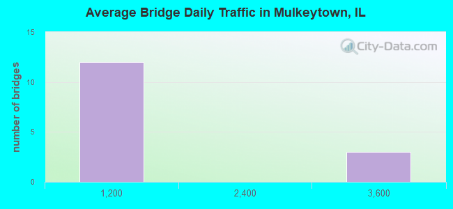
- 15,550Total average daily traffic
- 1,722Total average daily truck traffic
- National Bridge Inventory (NBI) Registered Bridges for Mulkeytown
- No street view available for this location
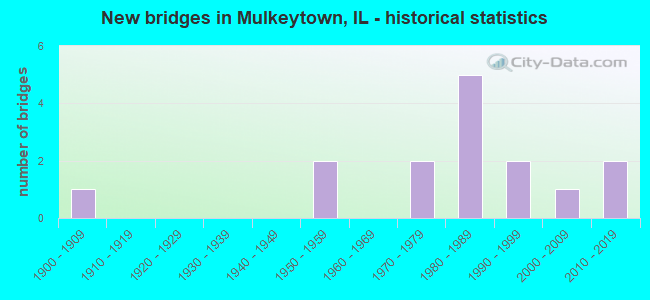
- New bridges - historical statistics
- 11900-1909
- 21950-1959
- 21970-1979
- 51980-1989
- 21990-1999
- 12000-2009
- 22010-2019
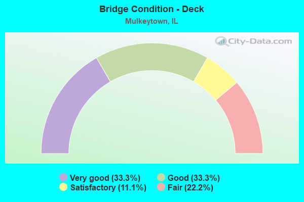
- Bridge Condition - Deck
- 33.3%Very good
- 33.3%Good
- 11.1%Satisfactory
- 22.2%Fair
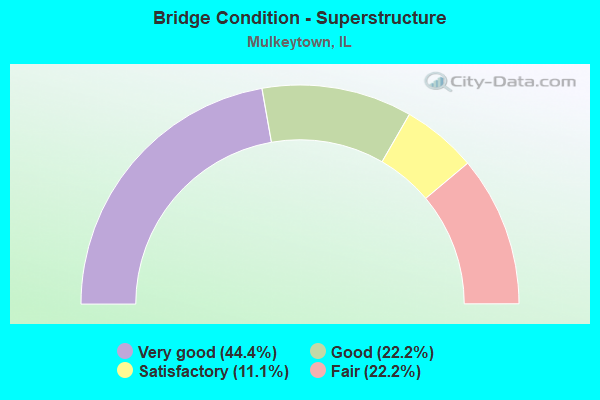
- Bridge Condition - Superstructure
- 44.4%Very good
- 22.2%Good
- 11.1%Satisfactory
- 22.2%Fair
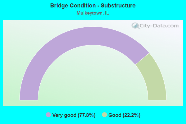
- Bridge Condition - Substructure
- 77.8%Very good
- 22.2%Good
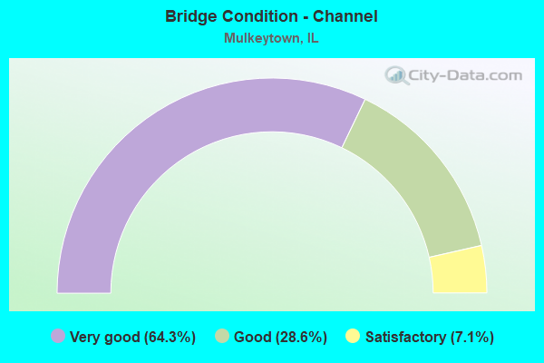
- Bridge Condition - Channel
- 64.3%Very good
- 28.6%Good
- 7.1%Satisfactory

- Bridge Condition - Culverts
- 60.0%Very good
- 20.0%Satisfactory
- 20.0%Fair
Find on map >> Show street view
Structure Number: 282005, Location: 0.15 E PERRY CO LINE (Lat: 37.975867, Lng: -89.150986), Route carried "on" structure: State highway 14, Year Built: 1955, Status: Open, Structure Length: 0.66m (2.17ft), Average Daily Traffic: 3,500 (year 2021), Truck Traffic: 14%, Average Future Daily Traffic: 3,707 (year 2032), Design Load: HS 20, Features Intersected: OVERFLOW L MUDDY R.
Minimum Vertical Clearance: 30+ m (98+ ft), Kilometerpoint: 7.322, Lanes on structure: 2, Base Highway Network: Yes, Owner: State Highway Agency, Approaching Roadway Width: 9.8m (32.2ft), Material/Design: Concrete continuous, Design/Construction: Culvert, Number Of Spans In Main Unit: 2, Length of Maximum Span: 3.0m (9.8ft)
Condition: Channel: Very good, Culverts: Satisfactory, Operating Rating: 42.1 metric tons, Method Used To Determine Operating Rating: Load Factor (LF) rating reported by rating factor (RF) method using MS18 loading, Inventory Rating: 25.3 metric tons, Method Used To Determine Inventory Rating: Load Factor (LF) rating reported by rating factor (RF) method using MS18 loading, Structural Evaluation: Equal to present minimum criteria, Waterway Adequacy: Equal to present desirable criteria, Approach Roadway Alignment: Equal to present desirable criteria, Length Of Structure Improvement: 1.52m (4.99ft), Designated Inspection Frequency: Every 24 months, Inspection Date: January 2021, Bridge Improvement Cost: $90,000, Roadway Improvement Cost: $15,000, Total Project Cost: $105,000
Find on map >> Show street view
Structure Number: 283201, Location: MULKEY TOWN ROAD (Lat: 38.008369, Lng: -89.113967), Route carried "on" structure: County highway , Year Built: 1975, Status: Open, Structure Length: 0.91m (2.99ft), Average Daily Traffic: 175 (year 2019), Truck Traffic: 13%, Average Future Daily Traffic: 159 (year 2032), Design Load: HS 15, Features Intersected: KING CREEK, Facility Carried by Structure: FAS 1875 MULKEYTWN
Minimum Vertical Clearance: 30+ m (98+ ft), Kilometerpoint: 1.706, Lanes on structure: 2, Owner: County Highway Agency, Approaching Roadway Width: 7.3m (24.0ft), Skew: 1 degrees, Material/Design: Concrete, Design/Construction: Channel Beam, Number Of Spans In Main Unit: 1, Length of Maximum Span: 8.8m (28.9ft), Curb-To-Curb Width: 7.3m (24.0ft), Out-to-Out Width: 8.0m (26.2ft)
Condition: Deck: Very good, Superstructure: Very good, Substructure: Good, Channel: Satisfactory, Operating Rating: 49.6 metric tons, Method Used To Determine Operating Rating: Load Factor (LF) rating reported by rating factor (RF) method using MS18 loading, Inventory Rating: 29.8 metric tons, Method Used To Determine Inventory Rating: Load Factor (LF) rating reported by rating factor (RF) method using MS18 loading, Structural Evaluation: Better than present minimum criteria, Deck Geometry: Somewhat better than minimum adequacy, Waterway Adequacy: Equal to present desirable criteria, Approach Roadway Alignment: Equal to present desirable criteria, Designated Inspection Frequency: Every 48 months, Inspection Date: May 2020, Deck Structure Type: Concrete Precast Panels, Wearing Surface/Protective System: Wearing Surface: Gravel
Find on map >> Show street view
Structure Number: 283215, Location: 1.5 M.S. MULKEYTOWN (Lat: 37.950028, Lng: -89.120786), Route carried "on" structure: County highway , Year Built: 1978, Status: Open, Structure Length: 0.79m (2.59ft), Average Daily Traffic: 50 (year 2019), Truck Traffic: 24%, Average Future Daily Traffic: 79 (year 2032), Design Load: HS 20, Features Intersected: BRANCH L. MUDDY RIV., Facility Carried by Structure: TR 273
Minimum Vertical Clearance: 30+ m (98+ ft), Kilometerpoint: 1.464, Lanes on structure: 2, Owner: Town or Township Highway Agency, Approaching Roadway Width: 7.3m (24.0ft), Skew: 3 degrees, Material/Design: Concrete, Design/Construction: Culvert, Number Of Spans In Main Unit: 2, Length of Maximum Span: 3.7m (12.1ft), Curb-To-Curb Width: 6.1m (20.0ft), Out-to-Out Width: 7.1m (23.3ft)
Condition: Channel: Very good, Culverts: Very good, Operating Rating: 44.4 metric tons, Method Used To Determine Operating Rating: Assigned rating based on Load Factor Design (LFD) reported by rating factor (RF) using MS18 loading, Inventory Rating: 32.4 metric tons, Method Used To Determine Inventory Rating: Assigned rating based on Load Factor Design (LFD) reported by rating factor (RF) using MS18 loading, Structural Evaluation: Equal to present desirable criteria, Deck Geometry: Somewhat better than minimum adequacy, Waterway Adequacy: Equal to present desirable criteria, Approach Roadway Alignment: Equal to present desirable criteria, Designated Inspection Frequency: Every 48 months, Inspection Date: August 2018, Deck Structure Type: Concrete Cast-file-Place, Wearing Surface/Protective System: Wearing Surface: Gravel
Find on map >> Show street view
Structure Number: 28324, Location: DAVID DEESOV LITTLE (Lat: 38.022606, Lng: -89.138250), Route carried "on" structure: County highway , Year Built: 1981, Status: Open, Structure Length: 3.63m (11.91ft), Average Daily Traffic: 900 (year 2019), Truck Traffic: 2%, Average Future Daily Traffic: 1,059 (year 2032), Design Load: HS 20, Features Intersected: LITTLE MUDDY RV, Facility Carried by Structure: FAS 1881
Minimum Vertical Clearance: 30+ m (98+ ft), Kilometerpoint: 0.016, Lanes on structure: 2, Owner: County Highway Agency, Approaching Roadway Width: 9.1m (29.9ft), Material/Design: Prestressed concrete, Design/Construction: Box Beam or Girders - Multiple, Number Of Spans In Main Unit: 3, Length of Maximum Span: 19.8m (65.0ft), Curb-To-Curb Width: 8.2m (26.9ft), Out-to-Out Width: 8.4m (27.6ft)
Condition: Deck: Good, Superstructure: Good, Substructure: Good, Channel: Good, Operating Rating: 44.2 metric tons, Method Used To Determine Operating Rating: Field evaluation and documented engineering judgment, Inventory Rating: 32.4 metric tons, Method Used To Determine Inventory Rating: Field evaluation and documented engineering judgment, Structural Evaluation: Better than present minimum criteria, Deck Geometry: Somewhat better than minimum adequacy, Waterway Adequacy: Somewhat better than minimum adequacy, Approach Roadway Alignment: Somewhat better than minimum adequacy, Designated Inspection Frequency: Every 48 months, Inspection Date: July 2018, Deck Structure Type: Concrete Precast Panels, Wearing Surface/Protective System: Wearing Surface: Bituminous
Find on map >> Show street view
Structure Number: 283253, Location: W VALIER (Lat: 38.023708, Lng: -89.123306), Route carried "on" structure: County highway , Year Built: 1983, Status: Open, Structure Length: 2.32m (7.61ft), Average Daily Traffic: 900 (year 2019), Truck Traffic: 2%, Average Future Daily Traffic: 1,059 (year 2032), Design Load: H 20, Features Intersected: KING CREEK, Facility Carried by Structure: FAS 1881
Minimum Vertical Clearance: 30+ m (98+ ft), Kilometerpoint: 1.352, Lanes on structure: 2, Owner: County Highway Agency, Approaching Roadway Width: 9.8m (32.2ft), Skew: 2 degrees, Material/Design: Prestressed concrete, Design/Construction: Box Beam or Girders - Multiple, Number Of Spans In Main Unit: 1, Length of Maximum Span: 22.6m (74.1ft), Curb-To-Curb Width: 9.1m (29.9ft), Out-to-Out Width: 9.4m (30.8ft)
Condition: Deck: Good, Superstructure: Good, Substructure: Very good, Channel: Good, Operating Rating: 62.5 metric tons, Method Used To Determine Operating Rating: Load Factor (LF) rating reported by rating factor (RF) method using MS18 loading, Inventory Rating: 37.6 metric tons, Method Used To Determine Inventory Rating: Load Factor (LF) rating reported by rating factor (RF) method using MS18 loading, Structural Evaluation: Better than present minimum criteria, Deck Geometry: Equal to present minimum criteria, Waterway Adequacy: Equal to present desirable criteria, Approach Roadway Alignment: Superior to present desirable criteria, Designated Inspection Frequency: Every 48 months, Inspection Date: January 2019, Deck Structure Type: Concrete Precast Panels, Wearing Surface/Protective System: Wearing Surface: Bituminous
Find on map >> Show street view
Structure Number: 283256, Location: WEST CHRISTOPHER (Lat: 37.956628, Lng: -89.137883), Route carried "on" structure: County highway , Year Built: 1983, Status: Open, Structure Length: 1.04m (3.41ft), Average Daily Traffic: 25 (year 2019), Average Future Daily Traffic: 106 (year 2032), Design Load: HS 20, Features Intersected: TRIB LITTLE MUDDY, Facility Carried by Structure: TR 12
Minimum Vertical Clearance: 30+ m (98+ ft), Kilometerpoint: 2.478, Lanes on structure: 2, Owner: Town or Township Highway Agency, Approaching Roadway Width: 3.7m (12.1ft), Material/Design: Concrete, Design/Construction: Culvert, Number Of Spans In Main Unit: 2, Length of Maximum Span: 4.9m (16.1ft), Curb-To-Curb Width: 7.4m (24.3ft), Out-to-Out Width: 8.0m (26.2ft)
Condition: Channel: Very good, Culverts: Very good, Operating Rating: 44.4 metric tons, Method Used To Determine Operating Rating: Assigned rating based on Load Factor Design (LFD) reported by rating factor (RF) using MS18 loading, Inventory Rating: 32.4 metric tons, Method Used To Determine Inventory Rating: Assigned rating based on Load Factor Design (LFD) reported by rating factor (RF) using MS18 loading, Structural Evaluation: Equal to present desirable criteria, Deck Geometry: Equal to present minimum criteria, Waterway Adequacy: Equal to present desirable criteria, Approach Roadway Alignment: Equal to present desirable criteria, Designated Inspection Frequency: Every 48 months, Inspection Date: August 2018, Deck Structure Type: Concrete Cast-file-Place
Find on map >> Show street view
Structure Number: 283261, Location: WEST CHRISTOPHER (Lat: 37.956908, Lng: -89.137747), Route carried "on" structure: County highway , Year Built: 1983, Status: Open, Structure Length: 0.79m (2.59ft), Average Daily Traffic: 25 (year 2019), Average Future Daily Traffic: 106 (year 2032), Design Load: HS 20, Features Intersected: TRIB LITTLE MUDDY, Facility Carried by Structure: TR 12
Minimum Vertical Clearance: 30+ m (98+ ft), Kilometerpoint: 2.446, Lanes on structure: 2, Owner: Town or Township Highway Agency, Approaching Roadway Width: 7.3m (24.0ft), Material/Design: Concrete, Design/Construction: Culvert, Number Of Spans In Main Unit: 2, Length of Maximum Span: 3.7m (12.1ft), Curb-To-Curb Width: 7.4m (24.3ft), Out-to-Out Width: 8.0m (26.2ft)
Condition: Channel: Very good, Culverts: Very good, Operating Rating: 44.4 metric tons, Method Used To Determine Operating Rating: Assigned rating based on Load Factor Design (LFD) reported by rating factor (RF) using MS18 loading, Inventory Rating: 32.4 metric tons, Method Used To Determine Inventory Rating: Assigned rating based on Load Factor Design (LFD) reported by rating factor (RF) using MS18 loading, Structural Evaluation: Equal to present desirable criteria, Deck Geometry: Equal to present minimum criteria, Waterway Adequacy: Better than present minimum criteria, Approach Roadway Alignment: Better than present minimum criteria, Designated Inspection Frequency: Every 48 months, Inspection Date: August 2018, Deck Structure Type: Concrete Cast-file-Place
Find on map >> Show street view
Structure Number: 283391, Location: 700N 250E (Lat: 37.965067, Lng: -89.106211), Route carried "on" structure: County highway , Year Built: 2007, Status: Open, Structure Length: 1.11m (3.64ft), Average Daily Traffic: 150 (year 2019), Truck Traffic: 7%, Average Future Daily Traffic: 106 (year 2032), Design Load: HS 20, Features Intersected: LITTLE MUDDY TRIB, Facility Carried by Structure: POPLAR STREET
Minimum Vertical Clearance: 30+ m (98+ ft), Kilometerpoint: 0.692, Lanes on structure: 2, Owner: Town or Township Highway Agency, Approaching Roadway Width: 6.1m (20.0ft), Material/Design: Prestressed concrete, Design/Construction: Box Beam or Girders - Multiple, Number Of Spans In Main Unit: 1, Length of Maximum Span: 10.4m (34.1ft), Curb-To-Curb Width: 7.3m (24.0ft), Out-to-Out Width: 7.3m (24.0ft)
Condition: Deck: Very good, Superstructure: Very good, Substructure: Very good, Channel: Very good, Operating Rating: 44.1 metric tons, Method Used To Determine Operating Rating: Assigned rating based on Load Factor Design (LFD) reported by rating factor (RF) using MS18 loading, Inventory Rating: 32.4 metric tons, Method Used To Determine Inventory Rating: Assigned rating based on Load Factor Design (LFD) reported by rating factor (RF) using MS18 loading, Structural Evaluation: Equal to present desirable criteria, Deck Geometry: Somewhat better than minimum adequacy, Waterway Adequacy: Equal to present desirable criteria, Approach Roadway Alignment: Equal to present desirable criteria, Designated Inspection Frequency: Every 48 months, Inspection Date: September 2021, Deck Structure Type: Concrete Precast Panels, Wearing Surface/Protective System: Wearing Surface: Gravel
Find on map >> Show street view
Structure Number: 283411, Location: 0.1MI S YELLOW BANKS (Lat: 37.948167, Lng: -89.095900), Route carried "on" structure: County highway , Year Built: 2013, Status: Open, Structure Length: 0.95m (3.12ft), Average Daily Traffic: 100 (year 2019), Truck Traffic: 9%, Average Future Daily Traffic: 40 (year 2033), Design Load: HS 25 or greater, Features Intersected: PRAIRIE CREEK, Facility Carried by Structure: TR 22
Minimum Vertical Clearance: 30+ m (98+ ft), Kilometerpoint: 0.209, Lanes on structure: 2, Owner: Town or Township Highway Agency, Approaching Roadway Width: 4.3m (14.1ft), Skew: 1 degrees, Material/Design: Prestressed concrete, Design/Construction: Box Beam or Girders - Multiple, Number Of Spans In Main Unit: 1, Length of Maximum Span: 8.7m (28.5ft), Curb-To-Curb Width: 7.3m (24.0ft), Out-to-Out Width: 7.3m (24.0ft)
Condition: Deck: Very good, Superstructure: Very good, Substructure: Very good, Channel: Very good, Operating Rating: 42.1 metric tons, Method Used To Determine Operating Rating: Assigned ratings based on Load and Resistance Factor Design (LRFD) reported by rating factor (RF) using HL93 loadings, Inventory Rating: 32.4 metric tons, Method Used To Determine Inventory Rating: Assigned ratings based on Load and Resistance Factor Design (LRFD) reported by rating factor (RF) using HL93 loadings, Structural Evaluation: Equal to present desirable criteria, Deck Geometry: Equal to present minimum criteria, Waterway Adequacy: Superior to present desirable criteria, Approach Roadway Alignment: Superior to present desirable criteria, Designated Inspection Frequency: Every 48 months, Inspection Date: September 2019, Deck Structure Type: Concrete Precast Panels, Wearing Surface/Protective System: Wearing Surface: Gravel
Find on map >> Show street view
Structure Number: 730038, Location: PERRY/FRANK CO LINE (Lat: 37.975869, Lng: -89.153892), Route carried "on" structure: State highway 14, Year Built: 2012, Status: Open, Structure Length: 3.99m (13.09ft), Average Daily Traffic: 3,500 (year 2021), Truck Traffic: 14%, Average Future Daily Traffic: 3,605 (year 2032), Design Load: HS 25 or greater, Features Intersected: LITTLE MUDDY RIVER
Minimum Vertical Clearance: 30+ m (98+ ft), Kilometerpoint: 7.065, Lanes on structure: 2, Base Highway Network: Yes, Owner: State Highway Agency, Approaching Roadway Width: 11.0m (36.1ft), Material/Design: Steel continuous, Design/Construction: Stringer/Multi-beam, Number Of Spans In Main Unit: 3, Length of Maximum Span: 17.1m (56.1ft), Curb-To-Curb Width: 11.0m (36.1ft), Out-to-Out Width: 11.9m (39.0ft)
Condition: Deck: Good, Superstructure: Very good, Substructure: Very good, Channel: Very good, Operating Rating: 97.2 metric tons, Method Used To Determine Operating Rating: Load Factor (LF) rating reported by rating factor (RF) method using MS18 loading, Inventory Rating: 63.8 metric tons, Method Used To Determine Inventory Rating: Load Factor (LF) rating reported by rating factor (RF) method using MS18 loading, Structural Evaluation: Equal to present desirable criteria, Deck Geometry: Somewhat better than minimum adequacy, Waterway Adequacy: Equal to present desirable criteria, Approach Roadway Alignment: Equal to present desirable criteria, Designated Inspection Frequency: Every 48 months, Inspection Date: November 2018, Deck Structure Type: Concrete Cast-file-Place, Wearing Surface/Protective System: Deck Protection: Epoxy Coated Reinforcing
Find on map >> Show street view
Structure Number: 732, Location: W OF FRANKLIN CO (Lat: 37.975858, Lng: -89.155989), Route carried "on" structure: State highway 14, Year Built: 1955, Status: Open, Structure Length: 1.18m (3.87ft), Average Daily Traffic: 3,500 (year 2021), Truck Traffic: 14%, Average Future Daily Traffic: 3,605 (year 2032), Design Load: HS 20, Features Intersected: STREAM W FRANKLIN CO
Minimum Vertical Clearance: 30+ m (98+ ft), Kilometerpoint: 6.888, Lanes on structure: 2, Base Highway Network: Yes, Owner: State Highway Agency, Approaching Roadway Width: 12.8m (42.0ft), Material/Design: Concrete continuous, Design/Construction: Culvert, Number Of Spans In Main Unit: 3, Length of Maximum Span: 3.7m (12.1ft)
Condition: Channel: Good, Culverts: Fair, Operating Rating: 58.0 metric tons, Method Used To Determine Operating Rating: Load Factor (LF) rating reported by rating factor (RF) method using MS18 loading, Inventory Rating: 34.7 metric tons, Method Used To Determine Inventory Rating: Load Factor (LF) rating reported by rating factor (RF) method using MS18 loading, Structural Evaluation: Somewhat better than minimum adequacy, Waterway Adequacy: Equal to present desirable criteria, Approach Roadway Alignment: Equal to present desirable criteria, Designated Inspection Frequency: Every 24 months, Inspection Date: January 2021
Find on map >> Show street view
Structure Number: 733138, Location: 1 MI W OF FRANKLINCO (Lat: 38.017217, Lng: -89.152831), Route carried "on" structure: County highway , Year Built: 1987, Status: Open, Structure Length: 1.28m (4.20ft), Average Daily Traffic: 900 (year 2019), Truck Traffic: 6%, Average Future Daily Traffic: 773 (year 2032), Design Load: HS 20, Features Intersected: BRANCH TO LTL MUDDY, Facility Carried by Structure: EAST PARK ST.-CH 7
Minimum Vertical Clearance: 30+ m (98+ ft), Kilometerpoint: 5.375, Lanes on structure: 2, Owner: County Highway Agency, Approaching Roadway Width: 6.7m (22.0ft), Material/Design: Prestressed concrete, Design/Construction: Box Beam or Girders - Multiple, Number Of Spans In Main Unit: 1, Length of Maximum Span: 12.5m (41.0ft), Curb-To-Curb Width: 8.6m (28.2ft), Out-to-Out Width: 8.6m (28.2ft)
Condition: Deck: Fair, Superstructure: Fair, Substructure: Very good, Channel: Very good, Operating Rating: 54.8 metric tons, Method Used To Determine Operating Rating: Load Factor (LF) rating reported by rating factor (RF) method using MS18 loading, Inventory Rating: 34.3 metric tons, Method Used To Determine Inventory Rating: Load Factor (LF) rating reported by rating factor (RF) method using MS18 loading, Structural Evaluation: Somewhat better than minimum adequacy, Deck Geometry: Somewhat better than minimum adequacy, Waterway Adequacy: Superior to present desirable criteria, Approach Roadway Alignment: Equal to present desirable criteria, Designated Inspection Frequency: Every 24 months, Inspection Date: January 2022, Deck Structure Type: Concrete Precast Panels, Wearing Surface/Protective System: Wearing Surface: Bituminous
Find on map >> Show street view
Structure Number: 733158, Location: 4 MI E OF DUQUOIN (Lat: 38.022403, Lng: -89.140242), Route carried "on" structure: County highway , Year Built: 1993, Status: Open, Structure Length: 12.41m (40.72ft), Average Daily Traffic: 900 (year 2019), Truck Traffic: 6%, Average Future Daily Traffic: 773 (year 2032), Design Load: HS 20, Features Intersected: LITTLE MUDDY OVERFLO, Facility Carried by Structure: FAS 1881
Minimum Vertical Clearance: 30+ m (98+ ft), Kilometerpoint: 6.630, Lanes on structure: 2, Owner: County Highway Agency, Approaching Roadway Width: 9.1m (29.9ft), Material/Design: Prestressed concrete, Design/Construction: Box Beam or Girders - Multiple, Number Of Spans In Main Unit: 6, Length of Maximum Span: 20.6m (67.6ft), Curb-To-Curb Width: 8.4m (27.6ft), Out-to-Out Width: 8.4m (27.6ft)
Condition: Deck: Fair, Superstructure: Fair, Substructure: Very good, Channel: Good, Operating Rating: 44.1 metric tons, Method Used To Determine Operating Rating: Assigned rating based on Load Factor Design (LFD) reported by rating factor (RF) using MS18 loading, Inventory Rating: 32.4 metric tons, Method Used To Determine Inventory Rating: Assigned rating based on Load Factor Design (LFD) reported by rating factor (RF) using MS18 loading, Structural Evaluation: Somewhat better than minimum adequacy, Deck Geometry: Somewhat better than minimum adequacy, Waterway Adequacy: Better than present minimum criteria, Approach Roadway Alignment: Equal to present desirable criteria, Designated Inspection Frequency: Every 24 months, Inspection Date: January 2022, Deck Structure Type: Concrete Precast Panels, Wearing Surface/Protective System: Wearing Surface: Other
Find on map >> Show street view
Structure Number: 733163, Location: 0.5 MI W FRKLN-PERRY (Lat: 38.019572, Lng: -89.147394), Route carried "on" structure: County highway , Year Built: 1997, Status: Open, Structure Length: 1.34m (4.40ft), Average Daily Traffic: 900 (year 2019), Truck Traffic: 6%, Average Future Daily Traffic: 773 (year 2032), Design Load: HS 20, Features Intersected: LITTLE MUDDY OVRFLOW, Facility Carried by Structure: FAS1881-E PARK ST
Minimum Vertical Clearance: 30+ m (98+ ft), Kilometerpoint: 5.922, Lanes on structure: 2, Owner: County Highway Agency, Approaching Roadway Width: 6.7m (22.0ft), Material/Design: Prestressed concrete, Design/Construction: Box Beam or Girders - Multiple, Number Of Spans In Main Unit: 1, Length of Maximum Span: 12.8m (42.0ft), Curb-To-Curb Width: 8.4m (27.6ft), Out-to-Out Width: 8.4m (27.6ft)
Condition: Deck: Satisfactory, Superstructure: Satisfactory, Substructure: Very good, Channel: Very good, Operating Rating: 53.8 metric tons, Method Used To Determine Operating Rating: Load Factor (LF) rating reported by rating factor (RF) method using MS18 loading, Inventory Rating: 33.4 metric tons, Method Used To Determine Inventory Rating: Load Factor (LF) rating reported by rating factor (RF) method using MS18 loading, Structural Evaluation: Equal to present minimum criteria, Deck Geometry: Somewhat better than minimum adequacy, Waterway Adequacy: Superior to present desirable criteria, Approach Roadway Alignment: Superior to present desirable criteria, Designated Inspection Frequency: Every 24 months, Inspection Date: January 2022, Deck Structure Type: Concrete Precast Panels, Wearing Surface/Protective System: Wearing Surface: Bituminous
Find on map >> Show street view
Structure Number: 289911, Location: 1 MI E PERRY CO. (Lat: 37.986939, Lng: -89.132339), Route carried "under" structure: County highway , Year Built: 1900, Structure Length: 0. m, Average Daily Traffic: 25 (year 2019), Truck Traffic: 4%, Features Intersected: TR 16, Facility Carried by Structure: ICG RR
Minimum Vertical Clearance: 3.51m (11.52ft), Kilometerpoint: 1.255, Lanes under structure: 2, Material/Design: Steel, Design/Construction: Stringer/Multi-beam, Length of Maximum Span: 8.2m (26.9ft)