Bridge Statistics for Nabesna, Alaska (AK)
Condition, Traffic, Stress, Structural Evaluation, Project Costs
- National Bridge Inventory (NBI) Statistics
- 10Number of bridges
- 157ft / 47.6mTotal length
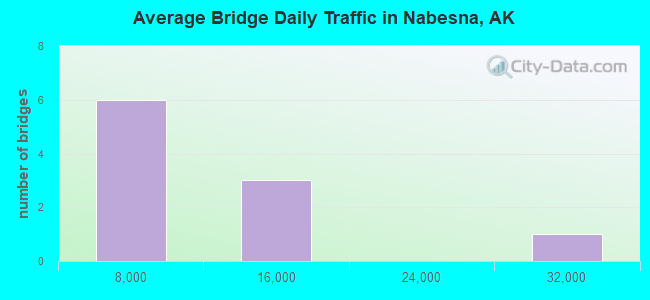
- 70,700Total average daily traffic
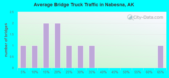
- 8,310Total average daily truck traffic
- National Bridge Inventory (NBI) Registered Bridges for Nabesna
- No street view available for this location
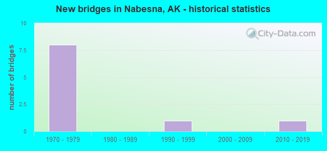
- New bridges - historical statistics
- 81970-1979
- 11990-1999
- 12010-2019
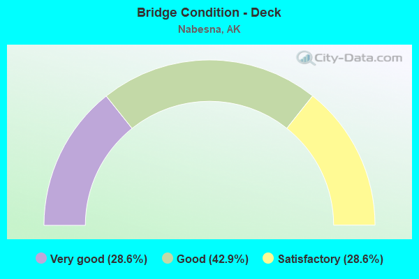
- Bridge Condition - Deck
- 28.6%Very good
- 42.9%Good
- 28.6%Satisfactory
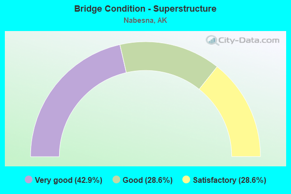
- Bridge Condition - Superstructure
- 42.9%Very good
- 28.6%Good
- 28.6%Satisfactory
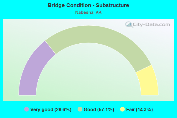
- Bridge Condition - Substructure
- 28.6%Very good
- 57.1%Good
- 14.3%Fair
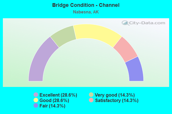
- Bridge Condition - Channel
- 28.6%Excellent
- 14.3%Very good
- 28.6%Good
- 14.3%Satisfactory
- 14.3%Fair
Find on map >> Show street view
Structure Number: 1214, Location: MILE POINT 1.3 (Lat: 60.776900, Lng: -148.695100), Route carried "on" structure: State highway , Year Built: 1999, Status: Open, Structure Length: 3.44m (11.29ft), Average Daily Traffic: 590 (year 2020), Truck Traffic: 12%, Average Future Daily Traffic: 760 (year 2039), Design Load: HS 25 or greater, Features Intersected: WHITTIER CREEK, Facility Carried by Structure: CAMP ROAD
Minimum Vertical Clearance: 30+ m (98+ ft), Kilometerpoint: 2.060, Lanes on structure: 2, Owner: State Highway Agency, Approaching Roadway Width: 12.8m (42.0ft), Material/Design: Prestressed concrete, Design/Construction: Tee Beam, Number Of Spans In Main Unit: 1, Length of Maximum Span: 33.5m (109.9ft), Curb-To-Curb Width: 12.7m (41.7ft), Out-to-Out Width: 13.7m (44.9ft)
Condition: Deck: Very good, Superstructure: Very good, Substructure: Good, Channel: Excellent, Operating Rating: 87.7 metric tons, Method Used To Determine Operating Rating: Load Factor (LF), Inventory Rating: 40.4 metric tons, Method Used To Determine Inventory Rating: Load Factor (LF), Structural Evaluation: Better than present minimum criteria, Deck Geometry: Superior to present desirable criteria, Waterway Adequacy: Superior to present desirable criteria, Approach Roadway Alignment: Equal to present desirable criteria, Designated Inspection Frequency: Every 24 months, Inspection Date: June 2021, Deck Structure Type: Other, Wearing Surface/Protective System: Wearing Surface: Bituminous, Membrane: Preformed Fabric, Deck Protection: Epoxy Coated Reinforcing
Find on map >> Show street view
Structure Number: 1216, Location: MILE POINT 0.1 (Lat: 59.412628, Lng: -135.999450), Route carried "on" structure: State highway NSP00, Year Built: 2017, Status: Open, Structure Length: 10.97m (35.99ft), Average Daily Traffic: 110 (year 2020), Truck Traffic: 21%, Average Future Daily Traffic: 180 (year 2039), Design Load: HL 93, Features Intersected: KLEHINI RIVER, Facility Carried by Structure: PORCUPINE CROSSING
Minimum Vertical Clearance: 30+ m (98+ ft), Kilometerpoint: 0.161, Lanes on structure: 2, Owner: State Highway Agency, Approaching Roadway Width: 9.0m (29.5ft), Skew: 3 degrees, Material/Design: Prestressed concrete, Design/Construction: Tee Beam, Number Of Spans In Main Unit: 3, Length of Maximum Span: 36.4m (119.4ft), Curb-To-Curb Width: 9.1m (29.9ft), Out-to-Out Width: 10.2m (33.5ft)
Condition: Deck: Very good, Superstructure: Very good, Substructure: Very good, Channel: Excellent, Operating Rating: 87.7 metric tons, Method Used To Determine Operating Rating: Load Factor (LF), Inventory Rating: 40.4 metric tons, Method Used To Determine Inventory Rating: Load Factor (LF), Structural Evaluation: Equal to present desirable criteria, Deck Geometry: Equal to present minimum criteria, Waterway Adequacy: Equal to present desirable criteria, Approach Roadway Alignment: Equal to present minimum criteria, Designated Inspection Frequency: Every 24 months, Inspection Date: June 2020, Deck Structure Type: Other, Wearing Surface/Protective System: Wearing Surface: Bituminous, Membrane: Preformed Fabric, Deck Protection: Epoxy Coated Reinforcing
Find on map >> Show street view
Structure Number: 123, Location: MILE POINT 24.0 (Lat: 61.450556, Lng: -149.374722), Route carried "on" structure: Interstate A16, Year Built: 1977, Status: Open, Structure Length: 3.23m (10.60ft), Average Daily Traffic: 15,500 (year 2020), Truck Traffic: 17%, Average Future Daily Traffic: 18,050 (year 2039), Design Load: HS 20, Features Intersected: EKLUTNA RIVER - N.B., Facility Carried by Structure: GLENN HIGHWAY
Minimum Vertical Clearance: 4.98m (16.34ft), Kilometerpoint: 38.681, Lanes on structure: 2, Base Highway Network: Yes, Owner: State Highway Agency, Approaching Roadway Width: 12.2m (40.0ft), Skew: 1 degrees, Material/Design: Prestressed concrete, Design/Construction: Tee Beam, Number Of Spans In Main Unit: 1, Length of Maximum Span: 31.1m (102.0ft), Curb-To-Curb Width: 11.0m (36.1ft), Out-to-Out Width: 12.1m (39.7ft)
Condition: Deck: Satisfactory, Superstructure: Satisfactory, Substructure: Good, Channel: Good, Operating Rating: 75.6 metric tons, Method Used To Determine Operating Rating: Load Factor (LF), Inventory Rating: 28.8 metric tons, Method Used To Determine Inventory Rating: Load Factor (LF), Structural Evaluation: Equal to present minimum criteria, Deck Geometry: Somewhat better than minimum adequacy, Waterway Adequacy: Equal to present desirable criteria, Approach Roadway Alignment: Equal to present desirable criteria, Designated Inspection Frequency: Every 24 months, Inspection Date: July 2021, Deck Structure Type: Other, Wearing Surface/Protective System: Wearing Surface: Bituminous, Membrane: Preformed Fabric
Find on map >> Show street view
Structure Number: 1241, Location: MILE POINT 129.0 (Lat: 61.987300, Lng: -146.947100), Route carried "on" structure: Interstate A14, Year Built: 1973, Status: Open, Structure Length: 8.69m (28.51ft), Average Daily Traffic: 820 (year 2020), Truck Traffic: 25%, Average Future Daily Traffic: 1,090 (year 2039), Design Load: HS 20, Features Intersected: LITTLE NELCHINA RIVER, Facility Carried by Structure: GLENN HIGHWAY
Minimum Vertical Clearance: 4.98m (16.34ft), Kilometerpoint: 207.560, Lanes on structure: 2, Base Highway Network: Yes, Owner: State Highway Agency, Approaching Roadway Width: 13.4m (44.0ft), Material/Design: Steel continuous, Design/Construction: Stringer/Multi-beam, Number Of Spans In Main Unit: 3, Length of Maximum Span: 33.5m (109.9ft), Curb-To-Curb Width: 13.4m (44.0ft), Out-to-Out Width: 13.7m (44.9ft)
Condition: Deck: Good, Superstructure: Good, Substructure: Very good, Channel: Very good, Operating Rating: 61.5 metric tons, Method Used To Determine Operating Rating: Load Factor (LF), Inventory Rating: 28.4 metric tons, Method Used To Determine Inventory Rating: Load Factor (LF), Structural Evaluation: Better than present minimum criteria, Deck Geometry: Superior to present desirable criteria, Waterway Adequacy: Equal to present desirable criteria, Approach Roadway Alignment: Equal to present desirable criteria, Designated Inspection Frequency: Every 24 months, Inspection Date: July 2021, Deck Structure Type: Concrete Cast-file-Place, Wearing Surface/Protective System: Wearing Surface: Monolithic Concrete
Find on map >> Show street view
Structure Number: 1242, Location: MILE POINT 96.8 (Lat: 65.439575, Lng: -145.526919), Route carried "on" structure: State highway 670, Year Built: 1971, Status: Open, Structure Length: 3.55m (11.65ft), Average Daily Traffic: 100 (year 2020), Truck Traffic: 13%, Average Future Daily Traffic: 140 (year 2039), Design Load: HS 20, Features Intersected: PTARMIGAN CREEK, Facility Carried by Structure: STEESE HIGHWAY
Minimum Vertical Clearance: 4.24m (13.91ft), Kilometerpoint: 155.719, Lanes on structure: 2, Base Highway Network: Yes, Owner: State Highway Agency, Approaching Roadway Width: 9.4m (30.8ft), Skew: 4 degrees, Material/Design: Steel, Design/Construction: Stringer/Multi-beam, Number Of Spans In Main Unit: 1, Length of Maximum Span: 33.5m (109.9ft), Curb-To-Curb Width: 8.5m (27.9ft), Out-to-Out Width: 8.8m (28.9ft)
Condition: Deck: Good, Superstructure: Very good, Substructure: Good, Channel: Fair, Operating Rating: 67.4 metric tons, Method Used To Determine Operating Rating: Load Factor (LF), Inventory Rating: 31.0 metric tons, Method Used To Determine Inventory Rating: Load Factor (LF), Structural Evaluation: Better than present minimum criteria, Deck Geometry: Better than present minimum criteria, Waterway Adequacy: Equal to present desirable criteria, Approach Roadway Alignment: Equal to present desirable criteria, Designated Inspection Frequency: Every 24 months, Inspection Date: August 2020, Deck Structure Type: Concrete Cast-file-Place, Wearing Surface/Protective System: Wearing Surface: Monolithic Concrete
Find on map >> Show street view
Structure Number: 1276, Location: MILE POINT 29.4 (Lat: 59.416594, Lng: -139.024183), Route carried "on" structure: State highway 942, Year Built: 1976, Status: Open, Structure Length: 13.10m (42.98ft), Average Daily Traffic: 40 (year 2020), Truck Traffic: 33%, Average Future Daily Traffic: 50 (year 2039), Design Load: HS 20, Features Intersected: DANGEROUS RIVER, Facility Carried by Structure: IRR:YAKUT/ALSEK RD
Minimum Vertical Clearance: 30+ m (98+ ft), Kilometerpoint: 47.263, Lanes on structure: 1, Owner: State Highway Agency, Approaching Roadway Width: 4.1m (13.5ft), Material/Design: Wood or Timber, Design/Construction: Stringer/Multi-beam, Number Of Spans In Main Unit: 3, Length of Maximum Span: 43.6m (143.0ft), Curb-To-Curb Width: 4.3m (14.1ft), Out-to-Out Width: 4.5m (14.8ft)
Condition: Deck: Satisfactory, Superstructure: Satisfactory, Substructure: Fair, Channel: Satisfactory, Operating Rating: 54.2 metric tons, Method Used To Determine Operating Rating: Load Factor (LF), Inventory Rating: 26.6 metric tons, Method Used To Determine Inventory Rating: Load Factor (LF), Structural Evaluation: Somewhat better than minimum adequacy, Deck Geometry: Equal to present minimum criteria, Waterway Adequacy: Equal to present desirable criteria, Approach Roadway Alignment: Equal to present desirable criteria, Designated Inspection Frequency: Every 24 months, Underwater Inspection Frequency: Every 60 months, Inspection Date: June 2020, Underwater Inspection Date: June 2021, Deck Structure Type: Wood or Timber, Wearing Surface/Protective System: Wearing Surface: Wood or Timber
Find on map >> Show street view
Structure Number: 1338, Location: MILE POINT 105.5 (Lat: 66.441231, Lng: -150.631456), Route carried "on" structure: State highway 65, Year Built: 1972, Year Reconstructed: 1992, Status: Open, Structure Length: 4.63m (15.19ft), Average Daily Traffic: 140 (year 2020), Truck Traffic: 61%, Average Future Daily Traffic: 170 (year 2039), Design Load: HS 25 or greater, Features Intersected: KANUTI RIVER, Facility Carried by Structure: DALTON HIGHWAY
Minimum Vertical Clearance: 30+ m (98+ ft), Kilometerpoint: 169.723, Lanes on structure: 2, Base Highway Network: Yes, Owner: State Highway Agency, Approaching Roadway Width: 8.2m (26.9ft), Material/Design: Steel, Design/Construction: Stringer/Multi-beam, Number Of Spans In Main Unit: 5, Length of Maximum Span: 9.1m (29.9ft), Curb-To-Curb Width: 8.2m (26.9ft), Out-to-Out Width: 8.4m (27.6ft)
Condition: Deck: Good, Superstructure: Good, Substructure: Good, Channel: Good, Inventory Rating: 65.5 metric tons, Method Used To Determine Inventory Rating: Load Factor (LF), Structural Evaluation: Better than present minimum criteria, Deck Geometry: Somewhat better than minimum adequacy, Waterway Adequacy: Equal to present desirable criteria, Approach Roadway Alignment: Equal to present desirable criteria, Designated Inspection Frequency: Every 24 months, Inspection Date: July 2020, Deck Structure Type: Concrete Precast Panels, Wearing Surface/Protective System: Wearing Surface: Monolithic Concrete, Deck Protection: Epoxy Coated Reinforcing
Find on map >> Show street view
Structure Number: 1239, Location: MILE POINT 117.8 (Lat: 61.097222, Lng: -149.838611), Route carried "under" structure: Interstate A31, Year Built: 1972, Structure Length: 0. m, Average Daily Traffic: 24,100 (year 2020), Truck Traffic: 17%, Features Intersected: RABBIT CREEK POC, Facility Carried by Structure: SEWARD HWY-UNDER
Minimum Vertical Clearance: 5.11m (16.77ft), Kilometerpoint: 189.499, Lanes under structure: 6, Material/Design: Steel continuous, Design/Construction: Orthotropic, Length of Maximum Span: 51.8m (169.9ft)
Find on map >> Show street view
Structure Number: 124, Location: MILE POINT 0.5 (Lat: 61.180833, Lng: -149.903889), Route carried "under" structure: State highway 544, Year Built: 1974, Structure Length: 0. m, Average Daily Traffic: 14,800 (year 2020), Truck Traffic: 3%, Features Intersected: WILLOW CREST POC, Facility Carried by Structure: TUDOR ROAD
Minimum Vertical Clearance: 5.03m (16.50ft), Kilometerpoint: 0.832, Lanes under structure: 5, Material/Design: Steel, Design/Construction: Orthotropic, Length of Maximum Span: 34.7m (113.8ft)
Find on map >> Show street view
Structure Number: 1275, Location: MILE POINT 0.8 (Lat: 64.837044, Lng: -147.731714), Route carried "under" structure: Interstate A45, Year Built: 1973, Structure Length: 0. m, Average Daily Traffic: 14,500 (year 2020), Truck Traffic: 5%, Features Intersected: LATHROP POC, Facility Carried by Structure: AIRPORT WAY
Minimum Vertical Clearance: 4.98m (16.34ft), Kilometerpoint: 1.230, Lanes under structure: 5, Material/Design: Steel continuous, Design/Construction: Orthotropic, Length of Maximum Span: 37.5m (123.0ft)