Bridge Statistics for New Castle, Colorado (CO)
Condition, Traffic, Stress, Structural Evaluation, Project Costs
- National Bridge Inventory (NBI) Statistics
- 14Number of bridges
- 135ft / 40.6mTotal length
- $619,000Total costs
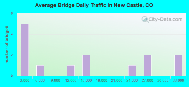
- 175,125Total average daily traffic
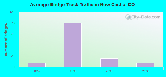
- 19,032Total average daily truck traffic
- National Bridge Inventory (NBI) Registered Bridges for New Castle
- No street view available for this location
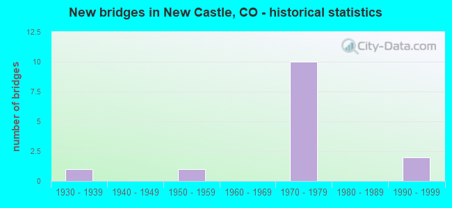
- New bridges - historical statistics
- 11930-1939
- 11950-1959
- 101970-1979
- 21990-1999
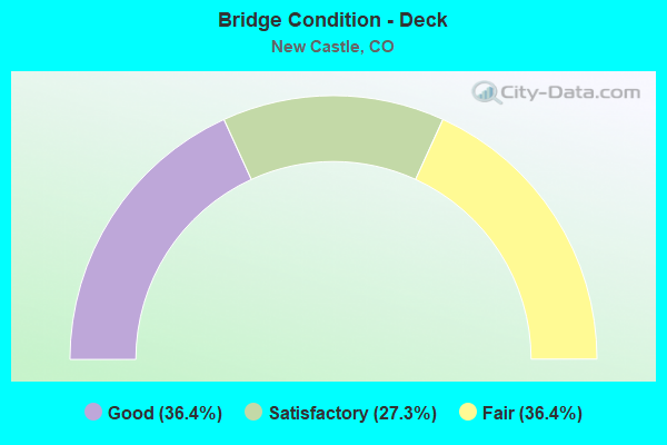
- Bridge Condition - Deck
- 36.4%Good
- 27.3%Satisfactory
- 36.4%Fair
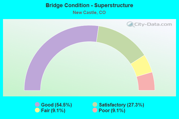
- Bridge Condition - Superstructure
- 54.5%Good
- 27.3%Satisfactory
- 9.1%Fair
- 9.1%Poor
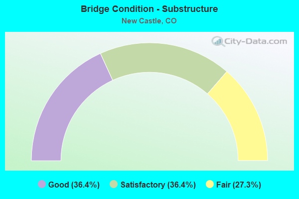
- Bridge Condition - Substructure
- 36.4%Good
- 36.4%Satisfactory
- 27.3%Fair
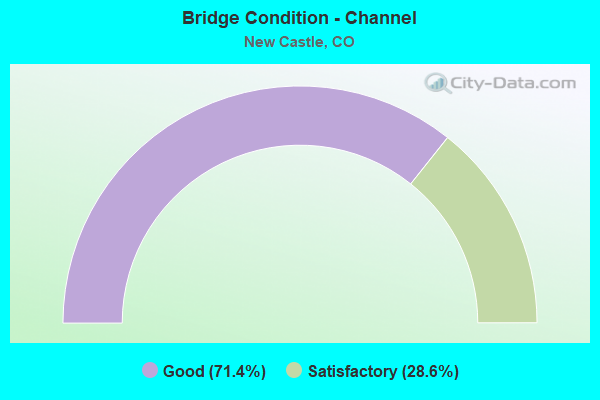
- Bridge Condition - Channel
- 71.4%Good
- 28.6%Satisfactory
Find on map >> Show street view
Structure Number: F-06-A, Location: IN NEW CASTLE (Lat: 39.571408, Lng: -107.539456), Route carried "on" structure: US 6D, Year Built: 1933, Status: Posted for load, Structure Length: 3.14m (10.30ft), Average Daily Traffic: 2,200 (year 2020), Truck Traffic: 7%, Average Future Daily Traffic: 2,882 (year 2040), Design Load: H 15, Features Intersected: ELK CREEK, Facility Carried by Structure: US 6 ML
Minimum Vertical Clearance: 30+ m (98+ ft), Kilometerpoint: 21.760, Lanes on structure: 2, Owner: State Highway Agency, Approaching Roadway Width: 8.5m (27.9ft), Material/Design: Steel, Design/Construction: Truss - Thru, Number Of Spans In Main Unit: 1, Length of Maximum Span: 30.5m (100.1ft), Curb-To-Curb Width: 7.3m (24.0ft), Out-to-Out Width: 7.7m (25.3ft)
Condition: Deck: Fair, Superstructure: Poor, Substructure: Satisfactory, Channel: Good, Operating Rating: 20.2 metric tons, Method Used To Determine Operating Rating: Load Factor (LF), Inventory Rating: 12.2 metric tons, Method Used To Determine Inventory Rating: Load Factor (LF), Structural Evaluation: High priority of replacement, Deck Geometry: High priority of replacement, Waterway Adequacy: Equal to present desirable criteria, Approach Roadway Alignment: Equal to present desirable criteria, Length Of Structure Improvement: 3.97m (13.02ft), Designated Inspection Frequency: Every 24 months, Critical Feature Inspection Frequency: Every 24 months, Inspection Date: August 2020, Critical Feature Inspection Date: August 2020, Bridge Improvement Cost: $413,000, Roadway Improvement Cost: $41,000, Total Project Cost: $619,000, Deck Structure Type: Concrete Cast-file-Place, Wearing Surface/Protective System: Wearing Surface: Bituminous
Find on map >> Show street view
Structure Number: F-06-K, Location: NEW CASTLE EXIT (Lat: 39.566747, Lng: -107.516447), Route carried "on" structure: ServiceInterstate 70A, Year Built: 1971, Status: Open, Structure Length: 4.11m (13.48ft), Average Daily Traffic: 31,000 (year 2020), Truck Traffic: 10%, Average Future Daily Traffic: 44,330 (year 2040), Design Load: HS 20+Mod, Features Intersected: UP RR AR, Facility Carried by Structure: I 70 ACCESS RD
Minimum Vertical Clearance: 30+ m (98+ ft), Kilometerpoint: 0.335, Lanes on structure: 2, Base Highway Network: Yes, Owner: State Highway Agency, Approaching Roadway Width: 8.5m (27.9ft), Material/Design: Steel continuous, Design/Construction: Stringer/Multi-beam, Number Of Spans In Main Unit: 3, Length of Maximum Span: 17.1m (56.1ft), Curb-To-Curb Width: 8.5m (27.9ft), Out-to-Out Width: 9.3m (30.5ft)
Condition: Deck: Fair, Superstructure: Satisfactory, Substructure: Satisfactory, Operating Rating: 46.4 metric tons, Method Used To Determine Operating Rating: Load Factor (LF), Inventory Rating: 27.8 metric tons, Method Used To Determine Inventory Rating: Load Factor (LF), Structural Evaluation: Equal to present minimum criteria, Deck Geometry: High priority of replacement, Underclear: Somewhat better than minimum adequacy, Approach Roadway Alignment: Equal to present desirable criteria, Designated Inspection Frequency: Every 24 months, Inspection Date: August 2020, Deck Structure Type: Concrete Cast-file-Place, Wearing Surface/Protective System: Wearing Surface: Bituminous
Find on map >> Show street view
Structure Number: F-06-L, Location: NEW CASTLE EXIT (Lat: 39.566156, Lng: -107.516692), Route carried "on" structure: County highway , Year Built: 1971, Status: Open, Structure Length: 6.18m (20.28ft), Average Daily Traffic: 9,130 (year 2008), Truck Traffic: 11%, Average Future Daily Traffic: 19,173 (year 2028), Design Load: HS 20+Mod, Features Intersected: I 70 ML, Facility Carried by Structure: COUNTY ROAD 240
Minimum Vertical Clearance: 30+ m (98+ ft), Kilometerpoint: 0.233, Lanes on structure: 2, Lanes under structure: 4, Owner: State Highway Agency, Approaching Roadway Width: 8.5m (27.9ft), Material/Design: Steel continuous, Design/Construction: Stringer/Multi-beam, Number Of Spans In Main Unit: 2, Length of Maximum Span: 30.2m (99.1ft), Curb-To-Curb Width: 8.5m (27.9ft), Out-to-Out Width: 9.3m (30.5ft)
Condition: Deck: Satisfactory, Superstructure: Good, Substructure: Good, Operating Rating: 53.6 metric tons, Method Used To Determine Operating Rating: Load Factor (LF), Inventory Rating: 32.1 metric tons, Method Used To Determine Inventory Rating: Load Factor (LF), Structural Evaluation: Better than present minimum criteria, Deck Geometry: Meets minimum limits, Underclear: Equal to present minimum criteria, Approach Roadway Alignment: Better than present minimum criteria, Designated Inspection Frequency: Every 24 months, Inspection Date: August 2020, Deck Structure Type: Concrete Cast-file-Place, Wearing Surface/Protective System: Wearing Surface: Bituminous
Find on map >> Show street view
Structure Number: F-06-M, Location: NEW CASTLE EXIT (Lat: 39.564211, Lng: -107.517250), Route carried "on" structure: ServiceInterstate 70A, Year Built: 1971, Status: Open, Structure Length: 8.75m (28.71ft), Average Daily Traffic: 25,000 (year 2020), Truck Traffic: 10%, Average Future Daily Traffic: 33,750 (year 2040), Design Load: HS 20+Mod, Features Intersected: COLORADO RIVER AR, Facility Carried by Structure: I 70 ACCESS RD
Minimum Vertical Clearance: 30+ m (98+ ft), Kilometerpoint: 0.022, Lanes on structure: 2, Owner: State Highway Agency, Approaching Roadway Width: 7.9m (25.9ft), Material/Design: Steel continuous, Design/Construction: Stringer/Multi-beam, Number Of Spans In Main Unit: 3, Length of Maximum Span: 32.9m (107.9ft), Curb-To-Curb Width: 7.6m (24.9ft), Out-to-Out Width: 8.4m (27.6ft)
Condition: Deck: Fair, Superstructure: Good, Substructure: Satisfactory, Channel: Good, Operating Rating: 48.2 metric tons, Method Used To Determine Operating Rating: Load Factor (LF), Inventory Rating: 28.8 metric tons, Method Used To Determine Inventory Rating: Load Factor (LF), Structural Evaluation: Equal to present minimum criteria, Deck Geometry: High priority of replacement, Waterway Adequacy: Superior to present desirable criteria, Approach Roadway Alignment: Equal to present desirable criteria, Designated Inspection Frequency: Every 24 months, Underwater Inspection Frequency: Every 60 months, Inspection Date: October 2020, Underwater Inspection Date: September 2020, Deck Structure Type: Concrete Cast-file-Place, Wearing Surface/Protective System: Wearing Surface: Monolithic Concrete
Find on map >> Show street view
Structure Number: F-06-O, Location: NEAR NEW CASTLE (Lat: 39.569522, Lng: -107.539739), Route carried "on" structure: Interstate 70A, Year Built: 1972, Status: Open, Structure Length: 1.80m (5.91ft), Average Daily Traffic: 12,500 (year 2020), Truck Traffic: 10%, Average Future Daily Traffic: 16,875 (year 2040), Design Load: HS 20+Mod, Features Intersected: ELK CREEK, Facility Carried by Structure: I 70 ML WBND
Minimum Vertical Clearance: 30+ m (98+ ft), Kilometerpoint: 167.494, Lanes on structure: 2, Base Highway Network: Yes, Owner: State Highway Agency, Approaching Roadway Width: 11.6m (38.1ft), Skew: 10 degrees, Material/Design: Steel, Design/Construction: Stringer/Multi-beam, Number Of Spans In Main Unit: 1, Length of Maximum Span: 17.0m (55.8ft), Curb-To-Curb Width: 12.8m (42.0ft), Out-to-Out Width: 13.6m (44.6ft)
Condition: Deck: Good, Superstructure: Good, Substructure: Good, Channel: Good, Operating Rating: 51.2 metric tons, Method Used To Determine Operating Rating: Load Factor (LF), Inventory Rating: 30.7 metric tons, Method Used To Determine Inventory Rating: Load Factor (LF), Structural Evaluation: Better than present minimum criteria, Deck Geometry: Equal to present desirable criteria, Waterway Adequacy: Superior to present desirable criteria, Approach Roadway Alignment: Equal to present desirable criteria, Designated Inspection Frequency: Every 24 months, Inspection Date: August 2020, Deck Structure Type: Concrete Cast-file-Place, Wearing Surface/Protective System: Wearing Surface: Bituminous
Find on map >> Show street view
Structure Number: F-06-P, Location: NEAR NEW CASTLE (Lat: 39.569333, Lng: -107.539661), Route carried "on" structure: Interstate 70A, Year Built: 1972, Status: Open, Structure Length: 1.80m (5.91ft), Average Daily Traffic: 12,500 (year 2020), Truck Traffic: 10%, Average Future Daily Traffic: 16,875 (year 2040), Design Load: HS 20+Mod, Features Intersected: ELK CREEK, Facility Carried by Structure: I 70 ML EBND
Minimum Vertical Clearance: 30+ m (98+ ft), Kilometerpoint: 167.497, Lanes on structure: 2, Base Highway Network: Yes, Owner: State Highway Agency, Approaching Roadway Width: 11.6m (38.1ft), Skew: 10 degrees, Material/Design: Steel, Design/Construction: Stringer/Multi-beam, Number Of Spans In Main Unit: 1, Length of Maximum Span: 17.1m (56.1ft), Curb-To-Curb Width: 12.8m (42.0ft), Out-to-Out Width: 13.6m (44.6ft)
Condition: Deck: Good, Superstructure: Good, Substructure: Satisfactory, Channel: Satisfactory, Operating Rating: 52.8 metric tons, Method Used To Determine Operating Rating: Load Factor (LF), Inventory Rating: 31.7 metric tons, Method Used To Determine Inventory Rating: Load Factor (LF), Structural Evaluation: Equal to present minimum criteria, Deck Geometry: Equal to present desirable criteria, Waterway Adequacy: Equal to present desirable criteria, Approach Roadway Alignment: Equal to present desirable criteria, Designated Inspection Frequency: Every 24 months, Inspection Date: August 2020, Deck Structure Type: Concrete Cast-file-Place, Wearing Surface/Protective System: Wearing Surface: Bituminous
Find on map >> Show street view
Structure Number: F-06-R, Location: 5 MI E of SILT (Lat: 39.557311, Lng: -107.562428), Route carried "on" structure: County highway , Year Built: 1972, Status: Open, Structure Length: 6.27m (20.57ft), Average Daily Traffic: 472 (year 2008), Truck Traffic: 11%, Average Future Daily Traffic: 990 (year 2028), Design Load: HS 20+Mod, Features Intersected: I 70 ML, Facility Carried by Structure: COUNTY ROAD 214
Minimum Vertical Clearance: 30+ m (98+ ft), Kilometerpoint: 0.087, Lanes on structure: 2, Lanes under structure: 4, Owner: State Highway Agency, Approaching Roadway Width: 7.9m (25.9ft), Material/Design: Steel continuous, Design/Construction: Stringer/Multi-beam, Number Of Spans In Main Unit: 2, Length of Maximum Span: 30.8m (101.0ft), Curb-To-Curb Width: 7.6m (24.9ft), Out-to-Out Width: 8.4m (27.6ft)
Condition: Deck: Satisfactory, Superstructure: Satisfactory, Substructure: Good, Operating Rating: 49.0 metric tons, Method Used To Determine Operating Rating: Load Factor (LF), Inventory Rating: 29.4 metric tons, Method Used To Determine Inventory Rating: Load Factor (LF), Structural Evaluation: Equal to present minimum criteria, Deck Geometry: Meets minimum limits, Underclear: Equal to present minimum criteria, Approach Roadway Alignment: Equal to present desirable criteria, Designated Inspection Frequency: Every 24 months, Inspection Date: July 2020, Deck Structure Type: Concrete Cast-file-Place, Wearing Surface/Protective System: Wearing Surface: Bituminous
Find on map >> Show street view
Structure Number: F-07-AS, Location: 1.5 MI E. OF NEW CASTLE E (Lat: 39.568856, Lng: -107.486422), Route carried "on" structure: ServiceInterstate 70A, Year Built: 1971, Status: Open, Structure Length: 5.51m (18.08ft), Average Daily Traffic: 31,000 (year 2020), Truck Traffic: 10%, Average Future Daily Traffic: 44,330 (year 2040), Design Load: HS 20+Mod, Features Intersected: I 70 ML, Facility Carried by Structure: I 70 ACCESS RD
Minimum Vertical Clearance: 30+ m (98+ ft), Kilometerpoint: 172.325, Lanes on structure: 1, Lanes under structure: 4, Base Highway Network: Yes, Owner: State Highway Agency, Approaching Roadway Width: 5.5m (18.0ft), Material/Design: Steel continuous, Design/Construction: Stringer/Multi-beam, Number Of Spans In Main Unit: 2, Length of Maximum Span: 27.0m (88.6ft), Curb-To-Curb Width: 5.5m (18.0ft), Out-to-Out Width: 6.2m (20.3ft)
Condition: Deck: Good, Superstructure: Good, Substructure: Fair, Operating Rating: 57.4 metric tons, Method Used To Determine Operating Rating: Load Factor (LF), Inventory Rating: 34.4 metric tons, Method Used To Determine Inventory Rating: Load Factor (LF), Structural Evaluation: Somewhat better than minimum adequacy, Deck Geometry: High priority of replacement, Underclear: Somewhat better than minimum adequacy, Approach Roadway Alignment: Equal to present minimum criteria, Designated Inspection Frequency: Every 24 months, Inspection Date: August 2020, Deck Structure Type: Concrete Cast-file-Place, Wearing Surface/Protective System: Wearing Surface: Monolithic Concrete
Find on map >> Show street view
Structure Number: GAR245-08.41-A, Location: 3.7 Mi NW of US Hwy 6 (Lat: 39.603361, Lng: -107.584278), Route carried "on" structure: County highway , Year Built: 1950, Year Reconstructed: 1992, Status: Open, Structure Length: 1.37m (4.49ft), Average Daily Traffic: 583 (year 2021), Truck Traffic: 18%, Average Future Daily Traffic: 740 (year 2041), Design Load: HS 20, Features Intersected: Main Elk Creek, Facility Carried by Structure: County Road 245
Minimum Vertical Clearance: 30+ m (98+ ft), Kilometerpoint: 4.441, Lanes on structure: 2, Owner: County Highway Agency, Approaching Roadway Width: 8.7m (28.5ft), Material/Design: Steel, Design/Construction: Stringer/Multi-beam, Number Of Spans In Main Unit: 1, Length of Maximum Span: 13.0m (42.7ft), Curb-To-Curb Width: 8.7m (28.5ft), Out-to-Out Width: 9.4m (30.8ft)
Condition: Deck: Fair, Superstructure: Fair, Substructure: Fair, Channel: Good, Operating Rating: 36.3 metric tons, Method Used To Determine Operating Rating: Field evaluation and documented engineering judgment, Inventory Rating: 22.0 metric tons, Method Used To Determine Inventory Rating: Load Factor (LF), Structural Evaluation: Somewhat better than minimum adequacy, Deck Geometry: Somewhat better than minimum adequacy, Waterway Adequacy: Equal to present desirable criteria, Approach Roadway Alignment: Equal to present minimum criteria, Designated Inspection Frequency: Every 24 months, Inspection Date: September 2021, Deck Structure Type: Concrete Cast-file-Place, Wearing Surface/Protective System: Wearing Surface: Bituminous
Find on map >> Show street view
Structure Number: GAR245-10.08-A, Location: 2.0 Mi NW of US Hwy 6 (Lat: 39.592889, Lng: -107.557722), Route carried "on" structure: County highway , Year Built: 1992, Status: Open, Structure Length: 0.93m (3.05ft), Average Daily Traffic: 734 (year 2021), Truck Traffic: 19%, Average Future Daily Traffic: 932 (year 2041), Features Intersected: East Elk Creek, Facility Carried by Structure: County Road 245
Minimum Vertical Clearance: 30+ m (98+ ft), Kilometerpoint: 1.793, Lanes on structure: 2, Owner: County Highway Agency, Approaching Roadway Width: 7.3m (24.0ft), Material/Design: Steel, Design/Construction: Stringer/Multi-beam, Number Of Spans In Main Unit: 1, Length of Maximum Span: 9.3m (30.5ft), Curb-To-Curb Width: 8.7m (28.5ft), Out-to-Out Width: 9.4m (30.8ft)
Condition: Deck: Satisfactory, Superstructure: Satisfactory, Substructure: Fair, Channel: Satisfactory, Operating Rating: 36.3 metric tons, Method Used To Determine Operating Rating: Field evaluation and documented engineering judgment, Inventory Rating: 23.9 metric tons, Method Used To Determine Inventory Rating: Load Factor (LF), Structural Evaluation: Somewhat better than minimum adequacy, Deck Geometry: Somewhat better than minimum adequacy, Waterway Adequacy: Better than present minimum criteria, Approach Roadway Alignment: Equal to present minimum criteria, Designated Inspection Frequency: Every 24 months, Inspection Date: September 2021, Deck Structure Type: Concrete Cast-file-Place, Wearing Surface/Protective System: Wearing Surface: Bituminous
Find on map >> Show street view
Structure Number: GAR335-03.89-A, Location: 2.5 Mi S I-70 New Castle (Lat: 39.551750, Lng: -107.558444), Route carried "on" structure: County highway , Year Built: 1992, Status: Open, Structure Length: 0.73m (2.40ft), Average Daily Traffic: 824 (year 2020), Truck Traffic: 24%, Average Future Daily Traffic: 1,046 (year 2040), Design Load: HS 20, Features Intersected: Garfield Creek, Facility Carried by Structure: County Road 335
Minimum Vertical Clearance: 30+ m (98+ ft), Kilometerpoint: 6.216, Lanes on structure: 2, Owner: County Highway Agency, Approaching Roadway Width: 7.6m (24.9ft), Skew: 2 degrees, Material/Design: Wood or Timber, Design/Construction: Slab, Number Of Spans In Main Unit: 1, Length of Maximum Span: 6.6m (21.7ft), Curb-To-Curb Width: 8.5m (27.9ft), Out-to-Out Width: 9.2m (30.2ft)
Condition: Deck: Good, Superstructure: Good, Substructure: Good, Channel: Good, Operating Rating: 48.9 metric tons, Method Used To Determine Operating Rating: Allowable Stress (AS), Inventory Rating: 34.7 metric tons, Method Used To Determine Inventory Rating: Allowable Stress (AS), Structural Evaluation: Better than present minimum criteria, Deck Geometry: Somewhat better than minimum adequacy, Waterway Adequacy: Better than present minimum criteria, Approach Roadway Alignment: Better than present minimum criteria, Designated Inspection Frequency: Every 24 months, Inspection Date: September 2021, Deck Structure Type: Wood or Timber, Wearing Surface/Protective System: Wearing Surface: Bituminous
Find on map >> Show street view
Structure Number: F-06-L, Location: NEW CASTLE EXIT (Lat: 39.566156, Lng: -107.516692), Route carried "under" structure: Interstate 70A, Year Built: 1971, Structure Length: 0. m, Average Daily Traffic: 3,182 (year 2016), Truck Traffic: 13%, Features Intersected: I 70 ML, Facility Carried by Structure: COUNTY ROAD 240
Minimum Vertical Clearance: 7.37m (24.18ft), Kilometerpoint: 0.232, Lanes on structure: 2, Lanes under structure: 4, Material/Design: Steel continuous, Design/Construction: Stringer/Multi-beam, Length of Maximum Span: 30.2m (99.1ft)
Find on map >> Show street view
Structure Number: F-06-R, Location: 5 MI E of SILT (Lat: 39.557311, Lng: -107.562428), Route carried "under" structure: Interstate 70A, Year Built: 1972, Structure Length: 0. m, Average Daily Traffic: 25,000 (year 2018), Truck Traffic: 13%, Features Intersected: I 70 ML, Facility Carried by Structure: COUNTY ROAD 214
Minimum Vertical Clearance: 5.64m (18.50ft), Kilometerpoint: 0.087, Lanes on structure: 2, Lanes under structure: 4, Material/Design: Steel continuous, Design/Construction: Stringer/Multi-beam, Length of Maximum Span: 30.8m (101.0ft)
Find on map >> Show street view
Structure Number: F-07-AS, Location: 1.5 MI E. OF NEW CASTLE E (Lat: 39.568856, Lng: -107.486422), Route carried "under" structure: Interstate 70A, Year Built: 1971, Structure Length: 0. m, Average Daily Traffic: 21,000 (year 2011), Truck Traffic: 12%, Features Intersected: I 70 ML, Facility Carried by Structure: I 70 ACCESS RD
Minimum Vertical Clearance: 5.28m (17.32ft), Kilometerpoint: 172.079, Lanes on structure: 1, Lanes under structure: 4, Material/Design: Steel continuous, Design/Construction: Stringer/Multi-beam, Length of Maximum Span: 27.0m (88.6ft)