Bridge Statistics for New Hope, Virginia (VA)
Condition, Traffic, Stress, Structural Evaluation, Project Costs
- National Bridge Inventory (NBI) Statistics
- 10Number of bridges
- 62ft / 19.3mTotal length
- $1,256,000Total costs
- 7,668Total average daily traffic
- 248Total average daily truck traffic
- 8,880Total future (year 2040) average daily traffic
- National Bridge Inventory (NBI) Registered Bridges for New Hope
- No street view available for this location
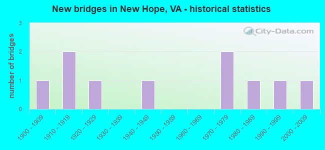
- New bridges - historical statistics
- 11900-1909
- 21910-1919
- 11920-1929
- 11940-1949
- 21970-1979
- 11980-1989
- 11990-1999
- 12000-2009
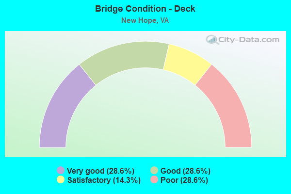
- Bridge Condition - Deck
- 28.6%Very good
- 28.6%Good
- 14.3%Satisfactory
- 28.6%Poor
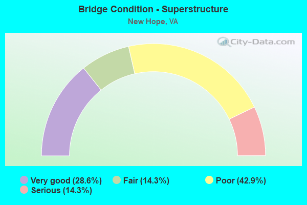
- Bridge Condition - Superstructure
- 28.6%Very good
- 14.3%Fair
- 42.9%Poor
- 14.3%Serious
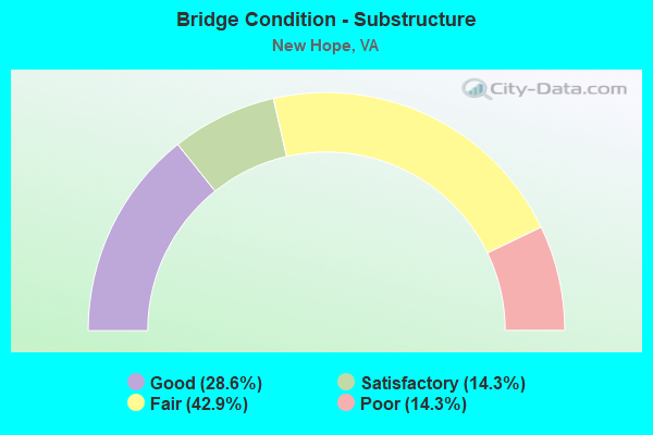
- Bridge Condition - Substructure
- 28.6%Good
- 14.3%Satisfactory
- 42.9%Fair
- 14.3%Poor
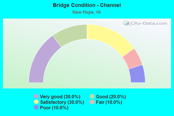
- Bridge Condition - Channel
- 30.0%Very good
- 20.0%Good
- 30.0%Satisfactory
- 10.0%Fair
- 10.0%Poor
Find on map >> Show street view
Structure Number: 189, Location: 0.15 RT 820W-0.23 RTE 608 (Lat: 38.151664, Lng: -78.924928), Route carried "on" structure: State highway 254, Year Built: 1974, Status: Open, Structure Length: 1.39m (4.56ft), Average Daily Traffic: 5,319 (year 2020), Truck Traffic: 4%, Average Future Daily Traffic: 5,851 (year 2040), Design Load: HS 20, Features Intersected: MEADOW RUN, Facility Carried by Structure: HERMITAGE RD
Minimum Vertical Clearance: 30+ m (98+ ft), Kilometerpoint: 30.220, Lanes on structure: 2, Base Highway Network: Yes, Owner: State Highway Agency, Approaching Roadway Width: 7.4m (24.3ft), Material/Design: Concrete, Design/Construction: Culvert, Number Of Spans In Main Unit: 4, Length of Maximum Span: 3.0m (9.8ft)
Condition: Channel: Satisfactory, Culverts: Good, Operating Rating: 89.8 metric tons, Method Used To Determine Operating Rating: Load Factor (LF), Inventory Rating: 59.9 metric tons, Method Used To Determine Inventory Rating: Load Factor (LF), Structural Evaluation: Better than present minimum criteria, Waterway Adequacy: Better than present minimum criteria, Approach Roadway Alignment: Equal to present desirable criteria, Designated Inspection Frequency: Every 24 months, Inspection Date: November 2021
Find on map >> Show street view
Structure Number: 2317, Location: 0.11 RT 782 - 1.43 RT 865 (Lat: 38.208286, Lng: -78.880611), Route carried "on" structure: County highway 778, Year Built: 1970, Status: Open, Structure Length: 0.79m (2.59ft), Average Daily Traffic: 727 (year 2020), Truck Traffic: 5%, Average Future Daily Traffic: 889 (year 2040), Design Load: HS 20+Mod, Features Intersected: POLECAT DRAFT, Facility Carried by Structure: PATTERSON MILL RD
Minimum Vertical Clearance: 30+ m (98+ ft), Kilometerpoint: 10.780, Lanes on structure: 2, Owner: State Highway Agency, Approaching Roadway Width: 6.1m (20.0ft), Skew: 1 degrees, Material/Design: Concrete, Design/Construction: Culvert, Number Of Spans In Main Unit: 4, Length of Maximum Span: 1.9m (6.2ft)
Condition: Channel: Fair, Culverts: Good, Operating Rating: 30.8 metric tons, Method Used To Determine Operating Rating: Load Factor (LF), Inventory Rating: 18.1 metric tons, Method Used To Determine Inventory Rating: Load Factor (LF), Structural Evaluation: Somewhat better than minimum adequacy, Waterway Adequacy: Equal to present minimum criteria, Approach Roadway Alignment: Better than present minimum criteria, Designated Inspection Frequency: Every 24 months, Inspection Date: June 2021
Find on map >> Show street view
Structure Number: 232, Location: 0.26 RT 777 - 2.05 RT 608 (Lat: 38.230161, Lng: -78.926064), Route carried "on" structure: County highway 778, Year Built: 1915, Status: Posted for load, Structure Length: 5.55m (18.21ft), Average Daily Traffic: 292 (year 2013), Average Future Daily Traffic: 450 (year 2040), Features Intersected: MIDDLE RIVER, Facility Carried by Structure: Knightly Mill Rd
Minimum Vertical Clearance: 4.74m (15.55ft), Kilometerpoint: 5.615, Lanes on structure: 1, Owner: State Highway Agency, Approaching Roadway Width: 4.9m (16.1ft), Material/Design: Steel, Design/Construction: Truss - Thru, Number Of Spans In Main Unit: 1, Length of Maximum Span: 55.5m (182.1ft), Curb or Sidewalk Widths: Left: 0.2m (0.7ft), Right: 0.2m (0.7ft), Curb-To-Curb Width: 4.4m (14.4ft), Out-to-Out Width: 4.7m (15.4ft)
Condition: Deck: Good, Superstructure: Poor, Substructure: Satisfactory, Channel: Very good, Operating Rating: 2.7 metric tons, Method Used To Determine Operating Rating: Load Factor (LF), Inventory Rating: 2.7 metric tons, Method Used To Determine Inventory Rating: Load Factor (LF), Structural Evaluation: High priority of replacement, Deck Geometry: High priority of replacement, Waterway Adequacy: Equal to present minimum criteria, Approach Roadway Alignment: High priority of replacement, Bridge Posting: Required (Relationship of Operating Rating to Maximum Legal Load: > 39.9% below), Length Of Structure Improvement: 5.55m (18.21ft), Designated Inspection Frequency: Every 12 months, Critical Feature Inspection Frequency: Every 12 months, Inspection Date: April 2021, Critical Feature Inspection Date: April 2021, Bridge Improvement Cost: $525,000, Roadway Improvement Cost: $53,000, Total Project Cost: $788,000, Deck Structure Type: Wood or Timber, Wearing Surface/Protective System: Wearing Surface: Bituminous
Find on map >> Show street view
Structure Number: 2334, Location: 0.15 RT 608 - 0.33 RT 820 (Lat: 38.162625, Lng: -78.918500), Route carried "on" structure: County highway 785, Year Built: 1987, Status: Open, Structure Length: 0.82m (2.69ft), Average Daily Traffic: 420 (year 2013), Average Future Daily Traffic: 647 (year 2040), Design Load: HS 20+Mod, Features Intersected: MEADOW RUN, Facility Carried by Structure: MADRID RD
Minimum Vertical Clearance: 30+ m (98+ ft), Kilometerpoint: 0.241, Lanes on structure: 2, Owner: State Highway Agency, Approaching Roadway Width: 6.1m (20.0ft), Material/Design: Concrete, Design/Construction: Slab, Number Of Spans In Main Unit: 1, Length of Maximum Span: 7.9m (25.9ft), Curb-To-Curb Width: 7.8m (25.6ft), Out-to-Out Width: 8.3m (27.2ft)
Condition: Deck: Very good, Superstructure: Very good, Substructure: Good, Channel: Satisfactory, Operating Rating: 84.4 metric tons, Method Used To Determine Operating Rating: Allowable Stress (AS), Inventory Rating: 52.6 metric tons, Method Used To Determine Inventory Rating: Allowable Stress (AS), Structural Evaluation: Better than present minimum criteria, Deck Geometry: Meets minimum limits, Waterway Adequacy: Equal to present minimum criteria, Approach Roadway Alignment: Equal to present minimum criteria, Designated Inspection Frequency: Every 24 months, Inspection Date: November 2021, Deck Structure Type: Concrete Cast-file-Place, Wearing Surface/Protective System: Deck Protection: Epoxy Coated Reinforcing
Find on map >> Show street view
Structure Number: 2335, Location: 0.45 RT 788 - 0.98 RT 608 (Lat: 38.172203, Lng: -78.931558), Route carried "on" structure: County highway 786, Year Built: 1940, Status: Open, Structure Length: 1.16m (3.81ft), Average Daily Traffic: 370 (year 2013), Average Future Daily Traffic: 420 (year 2040), Features Intersected: MEADOW RUN, Facility Carried by Structure: EAKLE RD
Minimum Vertical Clearance: 30+ m (98+ ft), Kilometerpoint: 1.839, Lanes on structure: 1, Owner: State Highway Agency, Approaching Roadway Width: 4.9m (16.1ft), Skew: 3 degrees, Material/Design: Concrete, Design/Construction: Slab, Number Of Spans In Main Unit: 2, Length of Maximum Span: 5.0m (16.4ft), Curb-To-Curb Width: 4.6m (15.1ft), Out-to-Out Width: 5.0m (16.4ft)
Condition: Deck: Poor, Superstructure: Poor, Substructure: Fair, Channel: Satisfactory, Operating Rating: 38.1 metric tons, Method Used To Determine Operating Rating: Field evaluation and documented engineering judgment, Inventory Rating: 22.7 metric tons, Method Used To Determine Inventory Rating: Field evaluation and documented engineering judgment, Structural Evaluation: Meets minimum limits, Deck Geometry: High priority of replacement, Waterway Adequacy: Equal to present minimum criteria, Approach Roadway Alignment: Equal to present minimum criteria, Length Of Structure Improvement: 1.13m (3.71ft), Designated Inspection Frequency: Every 12 months, Inspection Date: September 2021, Bridge Improvement Cost: $18,000, Roadway Improvement Cost: $2,000, Total Project Cost: $26,000, Deck Structure Type: Concrete Cast-file-Place, Wearing Surface/Protective System: Wearing Surface: Bituminous
Find on map >> Show street view
Structure Number: 2336, Location: 1.07 RT 788 - 0.01 RT 907 (Lat: 38.187506, Lng: -78.929314), Route carried "on" structure: County highway 787, Year Built: 1925, Year Reconstructed: 1973, Status: Open, Structure Length: 0.75m (2.46ft), Average Daily Traffic: 42 (year 2013), Average Future Daily Traffic: 48 (year 2040), Features Intersected: MEADOW RUN, Facility Carried by Structure: Old Mill Road
Minimum Vertical Clearance: 30+ m (98+ ft), Kilometerpoint: 3.485, Lanes on structure: 2, Owner: State Highway Agency, Approaching Roadway Width: 4.0m (13.1ft), Material/Design: Steel, Design/Construction: Stringer/Multi-beam, Number Of Spans In Main Unit: 1, Length of Maximum Span: 6.7m (22.0ft), Curb-To-Curb Width: 6.0m (19.7ft), Out-to-Out Width: 6.1m (20.0ft)
Condition: Deck: Satisfactory, Superstructure: Fair, Substructure: Fair, Channel: Very good, Operating Rating: 37.2 metric tons, Method Used To Determine Operating Rating: Load and Resistance Factor (LRFR), Inventory Rating: 28.1 metric tons, Method Used To Determine Inventory Rating: Load and Resistance Factor (LRFR), Structural Evaluation: Somewhat better than minimum adequacy, Deck Geometry: Meets minimum limits, Waterway Adequacy: High priority of corrective action, Approach Roadway Alignment: Somewhat better than minimum adequacy, Length Of Structure Improvement: 0.73m (2.40ft), Designated Inspection Frequency: Every 24 months, Inspection Date: August 2020, Bridge Improvement Cost: $50,000, Roadway Improvement Cost: $20,000, Total Project Cost: $70,000, Deck Structure Type: Wood or Timber, Wearing Surface/Protective System: Wearing Surface: Bituminous
Find on map >> Show street view
Structure Number: 2398, Location: 0.18 RT 612 - 0.16 RT 617 (Lat: 38.192206, Lng: -78.934864), Route carried "on" structure: County highway 907, Year Built: 1900, Status: Closed, Structure Length: 2.47m (8.10ft), Average Daily Traffic: 63 (year 2017), Average Future Daily Traffic: 70 (year 2040), Design Load: HS 20+Mod, Features Intersected: CHRISTIANS CREEK, Facility Carried by Structure: TILT HAMMER CR.
Minimum Vertical Clearance: 30+ m (98+ ft), Kilometerpoint: 0.290, Lanes on structure: 1, Owner: State Highway Agency, Approaching Roadway Width: 2.9m (9.5ft), Material/Design: Steel, Design/Construction: Truss - Thru, Number Of Spans In Main Unit: 1, Length of Maximum Span: 24.6m (80.7ft), Curb or Sidewalk Widths: Left: 0.2m (0.7ft), Right: 0.2m (0.7ft), Curb-To-Curb Width: 3.7m (12.1ft), Out-to-Out Width: 4.0m (13.1ft)
Condition: Deck: Good, Superstructure: Serious, Substructure: Poor, Channel: Very good, Operating Rating: 6.4 metric tons, Method Used To Determine Operating Rating: Load Factor (LF), Inventory Rating: 3.6 metric tons, Method Used To Determine Inventory Rating: Load Factor (LF), Deck Geometry: Meets minimum limits, Waterway Adequacy: Equal to present minimum criteria, Approach Roadway Alignment: High priority of corrective action, Bridge Posting: Required (Relationship of Operating Rating to Maximum Legal Load: > 39.9% below), Length Of Structure Improvement: 2.47m (8.10ft), Designated Inspection Frequency: Every 6 months, Critical Feature Inspection Frequency: Every 6 months, Inspection Date: October 2020, Critical Feature Inspection Date: October 2020, Bridge Improvement Cost: $234,000, Roadway Improvement Cost: $23,000, Total Project Cost: $350,000, Deck Structure Type: Wood or Timber, Wearing Surface/Protective System: Wearing Surface: Bituminous
Find on map >> Show street view
Structure Number: 24, Location: 0.34 RT 612 - 0.00 RT 617 (Lat: 38.190981, Lng: -78.932467), Route carried "on" structure: County highway 907, Year Built: 1913, Status: Posted for load, Structure Length: 0.70m (2.30ft), Average Daily Traffic: 63 (year 2017), Average Future Daily Traffic: 70 (year 2040), Features Intersected: MEADOW RUN, Facility Carried by Structure: Swisher Road
Minimum Vertical Clearance: 30+ m (98+ ft), Kilometerpoint: 0.547, Lanes on structure: 2, Owner: State Highway Agency, Approaching Roadway Width: 3.5m (11.5ft), Material/Design: Concrete, Design/Construction: Slab, Number Of Spans In Main Unit: 1, Length of Maximum Span: 3.7m (12.1ft), Curb-To-Curb Width: 4.9m (16.1ft), Out-to-Out Width: 7.9m (25.9ft)
Condition: Deck: Poor, Superstructure: Poor, Substructure: Fair, Channel: Poor, Operating Rating: 10.9 metric tons, Method Used To Determine Operating Rating: Field evaluation and documented engineering judgment, Inventory Rating: 7.3 metric tons, Method Used To Determine Inventory Rating: Field evaluation and documented engineering judgment, Structural Evaluation: High priority of corrective action, Deck Geometry: High priority of corrective action, Waterway Adequacy: High priority of corrective action, Approach Roadway Alignment: Meets minimum limits, Bridge Posting: Required (Relationship of Operating Rating to Maximum Legal Load: 0.1 - 9.9% below), Length Of Structure Improvement: 0.61m (2.00ft), Designated Inspection Frequency: Every 12 months, Inspection Date: April 2021, Bridge Improvement Cost: $15,000, Roadway Improvement Cost: $2,000, Total Project Cost: $22,000, Deck Structure Type: Concrete Cast-file-Place, Wearing Surface/Protective System: Wearing Surface: Bituminous
Find on map >> Show street view
Structure Number: 24268, Location: 0.65 RT 775 - 0.45 RT 777 (Lat: 38.236756, Lng: -78.922597), Route carried "on" structure: State highway 778, Year Built: 1995, Status: Open, Structure Length: 0.70m (2.30ft), Average Daily Traffic: 241 (year 2017), Average Future Daily Traffic: 286 (year 2040), Design Load: HS 20, Features Intersected: TRIB MIDDLE RIVER, Facility Carried by Structure: KNIGHTLY MILL RD
Minimum Vertical Clearance: 30+ m (98+ ft), Kilometerpoint: 4.489, Lanes on structure: 2, Owner: State Highway Agency, Approaching Roadway Width: 5.5m (18.0ft), Material/Design: Concrete, Design/Construction: Culvert, Number Of Spans In Main Unit: 2, Length of Maximum Span: 3.0m (9.8ft)
Condition: Channel: Good, Culverts: Good, Operating Rating: 52.6 metric tons, Method Used To Determine Operating Rating: Field evaluation and documented engineering judgment, Inventory Rating: 30.8 metric tons, Method Used To Determine Inventory Rating: Field evaluation and documented engineering judgment, Structural Evaluation: Better than present minimum criteria, Waterway Adequacy: Equal to present minimum criteria, Approach Roadway Alignment: Equal to present minimum criteria, Designated Inspection Frequency: Every 24 months, Inspection Date: October 2021
Find on map >> Show street view
Structure Number: 29364, Location: 1.24 Rt 775 - 0.51 Rt 777 (Lat: 38.231781, Lng: -78.897769), Route carried "on" structure: County highway 774, Year Built: 2009, Status: Open, Structure Length: 5.00m (16.40ft), Average Daily Traffic: 131 (year 2013), Average Future Daily Traffic: 149 (year 2040), Design Load: HS 20+Mod, Features Intersected: Middle River, Facility Carried by Structure: Cline River Road
Minimum Vertical Clearance: 30+ m (98+ ft), Kilometerpoint: 1.342, Lanes on structure: 2, Owner: State Highway Agency, Approaching Roadway Width: 4.9m (16.1ft), Material/Design: Steel continuous, Design/Construction: Stringer/Multi-beam, Number Of Spans In Main Unit: 2, Length of Maximum Span: 24.1m (79.1ft), Curb-To-Curb Width: 8.4m (27.6ft), Out-to-Out Width: 9.3m (30.5ft)
Condition: Deck: Very good, Superstructure: Very good, Substructure: Good, Channel: Good, Operating Rating: 83.5 metric tons, Method Used To Determine Operating Rating: Load and Resistance Factor (LRFR), Inventory Rating: 64.4 metric tons, Method Used To Determine Inventory Rating: Load and Resistance Factor (LRFR), Structural Evaluation: Better than present minimum criteria, Deck Geometry: Somewhat better than minimum adequacy, Waterway Adequacy: Somewhat better than minimum adequacy, Approach Roadway Alignment: Equal to present minimum criteria, Designated Inspection Frequency: Every 24 months, Inspection Date: March 2022, Deck Structure Type: Concrete Cast-file-Place, Wearing Surface/Protective System: Deck Protection: Epoxy Coated Reinforcing