Bridge Statistics for Newburg, West Virginia (WV)
Condition, Traffic, Stress, Structural Evaluation, Project Costs
- National Bridge Inventory (NBI) Statistics
- 39Number of bridges
- 207ft / 62.7mTotal length
- $8,077,000Total costs
- 25,015Total average daily traffic
- 2,834Total average daily truck traffic
- National Bridge Inventory (NBI) Registered Bridges for Newburg
- No street view available for this location
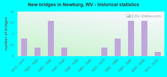
- New bridges - historical statistics
- 41910-1919
- 21920-1929
- 81930-1939
- 21940-1949
- 21970-1979
- 41980-1989
- 81990-1999
- 82000-2009
- 12010-2019
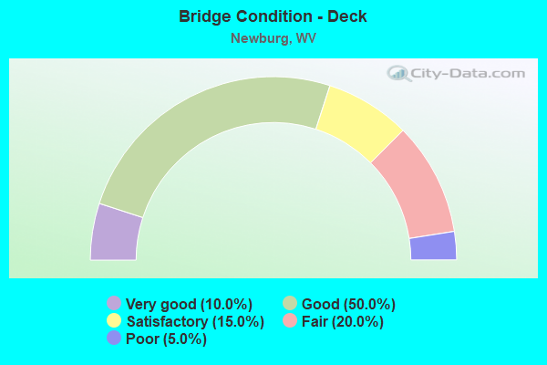
- Bridge Condition - Deck
- 10.0%Very good
- 50.0%Good
- 15.0%Satisfactory
- 20.0%Fair
- 5.0%Poor
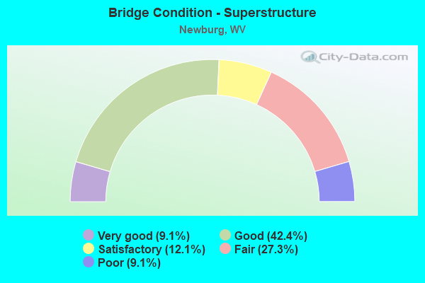
- Bridge Condition - Superstructure
- 9.1%Very good
- 42.4%Good
- 12.1%Satisfactory
- 27.3%Fair
- 9.1%Poor
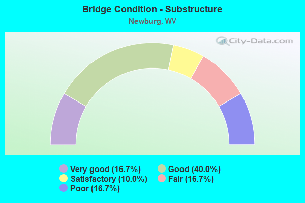
- Bridge Condition - Substructure
- 16.7%Very good
- 40.0%Good
- 10.0%Satisfactory
- 16.7%Fair
- 16.7%Poor
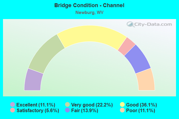
- Bridge Condition - Channel
- 11.1%Excellent
- 22.2%Very good
- 36.1%Good
- 5.6%Satisfactory
- 13.9%Fair
- 11.1%Poor
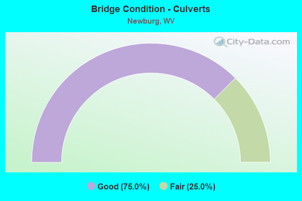
- Bridge Condition - Culverts
- 75.0%Good
- 25.0%Fair
Find on map >> Show street view
Structure Number: 39A074, Location: 0.01 MI SOUTH US ROUTE 50 (Lat: 39.329939, Lng: -79.824511), Route carried "on" structure: County highway 5028, Year Built: 1973, Status: Posted for load, Structure Length: 1.07m (3.51ft), Average Daily Traffic: 50 (year 2018), Average Future Daily Traffic: 65 (year 2038), Features Intersected: LITTLE SANDY CREEK, Facility Carried by Structure: PRES CO RT 50/28
Minimum Vertical Clearance: 30+ m (98+ ft), Kilometerpoint: 0.016, Lanes on structure: 1, Owner: State Highway Agency, Approaching Roadway Width: 4.9m (16.1ft), Material/Design: Steel, Design/Construction: Stringer/Multi-beam, Number Of Spans In Main Unit: 1, Length of Maximum Span: 10.3m (33.8ft), Curb-To-Curb Width: 4.3m (14.1ft), Out-to-Out Width: 4.3m (14.1ft)
Condition: Deck: Good, Superstructure: Fair, Substructure: Poor, Channel: Good, Operating Rating: 34.5 metric tons, Method Used To Determine Operating Rating: Load Factor (LF), Inventory Rating: 20.9 metric tons, Method Used To Determine Inventory Rating: Load Factor (LF), Structural Evaluation: Meets minimum limits, Deck Geometry: Equal to present minimum criteria, Waterway Adequacy: Better than present minimum criteria, Approach Roadway Alignment: Better than present minimum criteria, Bridge Posting: Required (Relationship of Operating Rating to Maximum Legal Load: 10.0 - 19.9% below), Length Of Structure Improvement: 1.68m (5.51ft), Designated Inspection Frequency: Every 24 months, Inspection Date: March 2020, Bridge Improvement Cost: $211,000, Roadway Improvement Cost: $173,000, Total Project Cost: $468,000 ( Estimate for 2020), Deck Structure Type: Wood or Timber
Find on map >> Show street view
Structure Number: 39A075, Location: 0.10 MI SOUTH CO RT 33/12 (Lat: 39.392469, Lng: -79.873389), Route carried "on" structure: County highway 3100, Year Built: 1930, Status: Posted for load, Structure Length: 1.52m (4.99ft), Average Daily Traffic: 50 (year 2019), Average Future Daily Traffic: 70 (year 2041), Features Intersected: RACCOON CREEK, Facility Carried by Structure: PRESTON CO RT 31
Minimum Vertical Clearance: 30+ m (98+ ft), Kilometerpoint: 0.161, Lanes on structure: 2, Owner: State Highway Agency, Approaching Roadway Width: 4.3m (14.1ft), Skew: 1 degrees, Material/Design: Steel, Design/Construction: Stringer/Multi-beam, Number Of Spans In Main Unit: 1, Length of Maximum Span: 13.5m (44.3ft), Curb or Sidewalk Widths: Left: 1.2m (3.9ft), Right: 0.0m, Curb-To-Curb Width: 5.6m (18.4ft), Out-to-Out Width: 7.2m (23.6ft)
Condition: Deck: Fair, Superstructure: Poor, Substructure: Fair, Channel: Fair, Operating Rating: 29.0 metric tons, Method Used To Determine Operating Rating: Load Factor (LF), Inventory Rating: 17.2 metric tons, Method Used To Determine Inventory Rating: Load Factor (LF), Structural Evaluation: Meets minimum limits, Deck Geometry: Meets minimum limits, Waterway Adequacy: Better than present minimum criteria, Approach Roadway Alignment: Meets minimum limits, Bridge Posting: Required (Relationship of Operating Rating to Maximum Legal Load: 10.0 - 19.9% below), Length Of Structure Improvement: 2.19m (7.19ft), Designated Inspection Frequency: Every 24 months, Inspection Date: June 2021, Bridge Improvement Cost: $264,000, Roadway Improvement Cost: $188,000, Total Project Cost: $527,000 ( Estimate for 2021), Deck Structure Type: Wood or Timber, Wearing Surface/Protective System: Wearing Surface: Wood or Timber
Find on map >> Show street view
Structure Number: 39A076, Location: 0.06 MI NORTH CO RT 33/11 (Lat: 39.395350, Lng: -79.870489), Route carried "on" structure: County highway 3300, Year Built: 1939, Status: Open, Structure Length: 0.74m (2.43ft), Average Daily Traffic: 250 (year 2018), Truck Traffic: 13%, Average Future Daily Traffic: 325 (year 2038), Features Intersected: COOKS RUN, Facility Carried by Structure: PRESTON CO RT 33
Minimum Vertical Clearance: 30+ m (98+ ft), Kilometerpoint: 2.655, Lanes on structure: 2, Owner: State Highway Agency, Approaching Roadway Width: 5.8m (19.0ft), Material/Design: Concrete continuous, Design/Construction: Slab, Number Of Spans In Main Unit: 2, Length of Maximum Span: 3.4m (11.2ft), Curb-To-Curb Width: 5.3m (17.4ft), Out-to-Out Width: 6.2m (20.3ft)
Condition: Deck: Fair, Superstructure: Fair, Substructure: Fair, Channel: Good, Operating Rating: 47.2 metric tons, Method Used To Determine Operating Rating: Field evaluation and documented engineering judgment, Inventory Rating: 21.8 metric tons, Method Used To Determine Inventory Rating: Field evaluation and documented engineering judgment, Structural Evaluation: Somewhat better than minimum adequacy, Deck Geometry: High priority of replacement, Waterway Adequacy: Equal to present desirable criteria, Approach Roadway Alignment: Better than present minimum criteria, Length Of Structure Improvement: 1.31m (4.30ft), Designated Inspection Frequency: Every 24 months, Inspection Date: May 2020, Bridge Improvement Cost: $162,000, Roadway Improvement Cost: $131,000, Total Project Cost: $351,000 ( Estimate for 2020), Deck Structure Type: Concrete Cast-file-Place, Wearing Surface/Protective System: Wearing Surface: Bituminous
Find on map >> Show street view
Structure Number: 39A077, Location: 0.24 MI NORTH CO RT 33/11 (Lat: 39.397650, Lng: -79.868869), Route carried "on" structure: County highway 3300, Year Built: 1987, Status: Open, Structure Length: 1.53m (5.02ft), Average Daily Traffic: 250 (year 2018), Truck Traffic: 13%, Average Future Daily Traffic: 325 (year 2038), Design Load: HS 25 or greater, Features Intersected: COOKS RUN, Facility Carried by Structure: PRESTON CO RT 33
Minimum Vertical Clearance: 30+ m (98+ ft), Kilometerpoint: 2.945, Lanes on structure: 2, Owner: State Highway Agency, Approaching Roadway Width: 5.8m (19.0ft), Skew: 3 degrees, Material/Design: Prestressed concrete, Design/Construction: Box Beam or Girders - Multiple, Number Of Spans In Main Unit: 1, Length of Maximum Span: 14.1m (46.3ft), Curb-To-Curb Width: 5.2m (17.1ft), Out-to-Out Width: 5.5m (18.0ft)
Condition: Superstructure: Good, Substructure: Good, Channel: Very good, Operating Rating: 88.9 metric tons, Method Used To Determine Operating Rating: Load Factor (LF), Inventory Rating: 59.9 metric tons, Method Used To Determine Inventory Rating: Load Factor (LF), Structural Evaluation: Better than present minimum criteria, Deck Geometry: High priority of replacement, Waterway Adequacy: Equal to present minimum criteria, Approach Roadway Alignment: Better than present minimum criteria, Length Of Structure Improvement: 2.19m (7.19ft), Designated Inspection Frequency: Every 24 months, Inspection Date: May 2020, Bridge Improvement Cost: $308,000, Roadway Improvement Cost: $279,000, Total Project Cost: $593,000 ( Estimate for 2020), Deck Structure Type: Other, Wearing Surface/Protective System: Wearing Surface: Bituminous, Deck Protection: Epoxy Coated Reinforcing
Find on map >> Show street view
Structure Number: 39A078, Location: 0.32 MI NORTH CO RT 33/11 (Lat: 39.398531, Lng: -79.868261), Route carried "on" structure: County highway 3300, Year Built: 1917, Status: Open, Structure Length: 0.75m (2.46ft), Average Daily Traffic: 250 (year 2018), Truck Traffic: 13%, Average Future Daily Traffic: 325 (year 2038), Features Intersected: COOKS RUN, Facility Carried by Structure: PRESTON CO RT 33
Minimum Vertical Clearance: 30+ m (98+ ft), Kilometerpoint: 3.074, Lanes on structure: 1, Owner: State Highway Agency, Approaching Roadway Width: 5.8m (19.0ft), Skew: 4 degrees, Material/Design: Concrete, Design/Construction: Arch - Deck, Number Of Spans In Main Unit: 1, Length of Maximum Span: 7.5m (24.6ft), Curb-To-Curb Width: 4.7m (15.4ft), Out-to-Out Width: 5.5m (18.0ft)
Condition: Superstructure: Fair, Channel: Good, Operating Rating: 47.2 metric tons, Method Used To Determine Operating Rating: Field evaluation and documented engineering judgment, Inventory Rating: 21.8 metric tons, Method Used To Determine Inventory Rating: Field evaluation and documented engineering judgment, Structural Evaluation: Somewhat better than minimum adequacy, Deck Geometry: High priority of replacement, Waterway Adequacy: Somewhat better than minimum adequacy, Approach Roadway Alignment: Meets minimum limits, Length Of Structure Improvement: 1.46m (4.79ft), Designated Inspection Frequency: Every 24 months, Inspection Date: May 2020, Bridge Improvement Cost: $182,000, Roadway Improvement Cost: $163,000, Total Project Cost: $414,000 ( Estimate for 2020)
Find on map >> Show street view
Structure Number: 39A08, Location: 0.21 MI SOUTH CO RT 37 (Lat: 39.404169, Lng: -79.866981), Route carried "on" structure: County highway 3300, Year Built: 1939, Status: Open, Structure Length: 0.72m (2.36ft), Average Daily Traffic: 250 (year 2018), Truck Traffic: 13%, Average Future Daily Traffic: 325 (year 2038), Features Intersected: COOKS RUN, Facility Carried by Structure: PRESTON CO RT 33
Minimum Vertical Clearance: 30+ m (98+ ft), Kilometerpoint: 3.718, Lanes on structure: 2, Owner: State Highway Agency, Approaching Roadway Width: 5.5m (18.0ft), Skew: 4 degrees, Material/Design: Concrete, Design/Construction: Slab, Number Of Spans In Main Unit: 1, Length of Maximum Span: 6.4m (21.0ft), Curb-To-Curb Width: 5.0m (16.4ft), Out-to-Out Width: 5.9m (19.4ft)
Condition: Deck: Poor, Superstructure: Poor, Substructure: Satisfactory, Channel: Good, Operating Rating: 47.2 metric tons, Method Used To Determine Operating Rating: Field evaluation and documented engineering judgment, Inventory Rating: 21.8 metric tons, Method Used To Determine Inventory Rating: Field evaluation and documented engineering judgment, Structural Evaluation: Meets minimum limits, Deck Geometry: High priority of replacement, Waterway Adequacy: Equal to present minimum criteria, Approach Roadway Alignment: Better than present minimum criteria, Length Of Structure Improvement: 1.28m (4.20ft), Designated Inspection Frequency: Every 24 months, Inspection Date: May 2020, Bridge Improvement Cost: $175,000, Roadway Improvement Cost: $141,000, Total Project Cost: $393,000 ( Estimate for 2020), Deck Structure Type: Concrete Cast-file-Place, Wearing Surface/Protective System: Wearing Surface: Bituminous
Find on map >> Show street view
Structure Number: 39A081, Location: 0.01 MI SOUTH CO RT 37 (Lat: 39.406569, Lng: -79.865211), Route carried "on" structure: County highway 3300, Year Built: 1939, Status: Open, Structure Length: 0.75m (2.46ft), Average Daily Traffic: 250 (year 2018), Truck Traffic: 13%, Average Future Daily Traffic: 325 (year 2038), Features Intersected: COOKS RUN, Facility Carried by Structure: PRESTON CO RT 33
Minimum Vertical Clearance: 30+ m (98+ ft), Kilometerpoint: 4.039, Lanes on structure: 2, Owner: State Highway Agency, Approaching Roadway Width: 4.9m (16.1ft), Skew: 1 degrees, Material/Design: Concrete continuous, Design/Construction: Slab, Number Of Spans In Main Unit: 2, Length of Maximum Span: 3.4m (11.2ft), Curb-To-Curb Width: 5.1m (16.7ft), Out-to-Out Width: 6.0m (19.7ft)
Condition: Deck: Fair, Superstructure: Fair, Substructure: Fair, Channel: Poor, Operating Rating: 47.2 metric tons, Method Used To Determine Operating Rating: Field evaluation and documented engineering judgment, Inventory Rating: 21.8 metric tons, Method Used To Determine Inventory Rating: Field evaluation and documented engineering judgment, Structural Evaluation: Somewhat better than minimum adequacy, Deck Geometry: High priority of replacement, Waterway Adequacy: Equal to present minimum criteria, Approach Roadway Alignment: Equal to present minimum criteria, Length Of Structure Improvement: 1.31m (4.30ft), Designated Inspection Frequency: Every 24 months, Inspection Date: May 2020, Bridge Improvement Cost: $153,000, Roadway Improvement Cost: $132,000, Total Project Cost: $354,000 ( Estimate for 2020), Deck Structure Type: Concrete Cast-file-Place, Wearing Surface/Protective System: Wearing Surface: Bituminous
Find on map >> Show street view
Structure Number: 39A083, Location: 0.14 MI SOUTH CO RT 35 (Lat: 39.438081, Lng: -79.848300), Route carried "on" structure: County highway 3300, Year Built: 1993, Status: Open, Structure Length: 3.70m (12.14ft), Average Daily Traffic: 600 (year 2018), Truck Traffic: 13%, Average Future Daily Traffic: 800 (year 2038), Design Load: HS 25 or greater, Features Intersected: THREEFORK CREEK, Facility Carried by Structure: PRESTON CO RT 33
Minimum Vertical Clearance: 30+ m (98+ ft), Kilometerpoint: 8.449, Lanes on structure: 2, Owner: State Highway Agency, Approaching Roadway Width: 5.5m (18.0ft), Skew: 2 degrees, Material/Design: Prestressed concrete, Design/Construction: Box Beam or Girders - Multiple, Number Of Spans In Main Unit: 2, Length of Maximum Span: 17.6m (57.7ft), Curb-To-Curb Width: 6.9m (22.6ft), Out-to-Out Width: 7.4m (24.3ft)
Condition: Deck: Satisfactory, Superstructure: Satisfactory, Substructure: Good, Channel: Satisfactory, Operating Rating: 88.9 metric tons, Method Used To Determine Operating Rating: Load Factor (LF), Inventory Rating: 62.6 metric tons, Method Used To Determine Inventory Rating: Load Factor (LF), Structural Evaluation: Equal to present minimum criteria, Deck Geometry: Meets minimum limits, Waterway Adequacy: Equal to present minimum criteria, Approach Roadway Alignment: Equal to present desirable criteria, Designated Inspection Frequency: Every 48 months, Inspection Date: July 2019, Deck Structure Type: Other, Wearing Surface/Protective System: Wearing Surface: Bituminous, Deck Protection: Epoxy Coated Reinforcing
Find on map >> Show street view
Structure Number: 39A086, Location: 0.10 MI NORTH CO RT 33/9 (Lat: 39.418919, Lng: -79.890650), Route carried "on" structure: County highway 3311, Year Built: 1989, Status: Open, Structure Length: 1.74m (5.71ft), Average Daily Traffic: 50 (year 2018), Average Future Daily Traffic: 65 (year 2038), Design Load: HS 25 or greater, Features Intersected: THREE FORK CREEK, Facility Carried by Structure: PRES CO RT 33/11
Minimum Vertical Clearance: 30+ m (98+ ft), Kilometerpoint: 3.734, Lanes on structure: 1, Owner: State Highway Agency, Approaching Roadway Width: 3.7m (12.1ft), Material/Design: Prestressed concrete, Design/Construction: Box Beam or Girders - Multiple, Number Of Spans In Main Unit: 1, Length of Maximum Span: 16.5m (54.1ft), Curb-To-Curb Width: 4.6m (15.1ft), Out-to-Out Width: 4.6m (15.1ft)
Condition: Deck: Good, Superstructure: Good, Substructure: Good, Channel: Very good, Operating Rating: 88.9 metric tons, Method Used To Determine Operating Rating: Load Factor (LF), Inventory Rating: 63.5 metric tons, Method Used To Determine Inventory Rating: Load Factor (LF), Structural Evaluation: Better than present minimum criteria, Deck Geometry: Better than present minimum criteria, Waterway Adequacy: Equal to present desirable criteria, Approach Roadway Alignment: Equal to present minimum criteria, Designated Inspection Frequency: Every 48 months, Inspection Date: June 2020, Deck Structure Type: Other, Wearing Surface/Protective System: Deck Protection: Epoxy Coated Reinforcing
Find on map >> Show street view
Structure Number: 39A088, Location: 0.02 MI EAST CO RT 33 (Lat: 39.440369, Lng: -79.849531), Route carried "on" structure: County highway 3500, Year Built: 1918, Status: Open, Structure Length: 0.62m (2.03ft), Average Daily Traffic: 10 (year 2018), Average Future Daily Traffic: 13 (year 2038), Features Intersected: MARTINS RUN, Facility Carried by Structure: PRESTON CO RT 35
Minimum Vertical Clearance: 30+ m (98+ ft), Kilometerpoint: 0.032, Lanes on structure: 1, Owner: State Highway Agency, Approaching Roadway Width: 3.7m (12.1ft), Skew: 3 degrees, Material/Design: Concrete, Design/Construction: Arch - Deck, Number Of Spans In Main Unit: 1, Length of Maximum Span: 6.2m (20.3ft), Curb or Sidewalk Widths: Left: 0.1m (0.3ft), Right: 0.1m (0.3ft), Curb-To-Curb Width: 4.0m (13.1ft), Out-to-Out Width: 4.9m (16.1ft)
Condition: Superstructure: Satisfactory, Channel: Good, Operating Rating: 47.2 metric tons, Method Used To Determine Operating Rating: Field evaluation and documented engineering judgment, Inventory Rating: 21.8 metric tons, Method Used To Determine Inventory Rating: Field evaluation and documented engineering judgment, Structural Evaluation: Equal to present minimum criteria, Deck Geometry: Somewhat better than minimum adequacy, Waterway Adequacy: Better than present minimum criteria, Approach Roadway Alignment: Somewhat better than minimum adequacy, Length Of Structure Improvement: 1.28m (4.20ft), Designated Inspection Frequency: Every 24 months, Inspection Date: May 2020, Bridge Improvement Cost: $159,000, Roadway Improvement Cost: $132,000, Total Project Cost: $367,000 ( Estimate for 2020)
Find on map >> Show street view
Structure Number: 39A089, Location: 0.41 MI EAST CO RT 92/8 (Lat: 39.447900, Lng: -79.823111), Route carried "on" structure: County highway 3500, Year Built: 1992, Status: Open, Structure Length: 3.09m (10.14ft), Average Daily Traffic: 10 (year 2017), Average Future Daily Traffic: 13 (year 2037), Design Load: HS 25 or greater, Features Intersected: THREE FORK CREEK, Facility Carried by Structure: PRESTON CO RT 35
Minimum Vertical Clearance: 30+ m (98+ ft), Kilometerpoint: 2.832, Lanes on structure: 1, Owner: State Highway Agency, Approaching Roadway Width: 3.0m (9.8ft), Material/Design: Prestressed concrete, Design/Construction: Box Beam or Girders - Multiple, Number Of Spans In Main Unit: 2, Length of Maximum Span: 14.6m (47.9ft), Curb-To-Curb Width: 4.5m (14.8ft), Out-to-Out Width: 4.6m (15.1ft)
Condition: Deck: Good, Superstructure: Good, Substructure: Good, Channel: Good, Operating Rating: 88.9 metric tons, Method Used To Determine Operating Rating: Load Factor (LF), Inventory Rating: 58.0 metric tons, Method Used To Determine Inventory Rating: Load Factor (LF), Structural Evaluation: Better than present minimum criteria, Deck Geometry: Equal to present minimum criteria, Waterway Adequacy: Better than present minimum criteria, Approach Roadway Alignment: Equal to present minimum criteria, Designated Inspection Frequency: Every 48 months, Inspection Date: May 2019, Deck Structure Type: Other, Wearing Surface/Protective System: Deck Protection: Epoxy Coated Reinforcing
Find on map >> Show street view
Structure Number: 39A094, Location: 0.27 MI WEST CO RT 39/2 (Lat: 39.390400, Lng: -79.807100), Route carried "on" structure: County highway 3900, Year Built: 1940, Status: Open, Structure Length: 1.13m (3.71ft), Average Daily Traffic: 250 (year 2019), Truck Traffic: 7%, Average Future Daily Traffic: 350 (year 2041), Features Intersected: RACCOON CREEK, Facility Carried by Structure: PRESTON CO RT 39
Minimum Vertical Clearance: 30+ m (98+ ft), Kilometerpoint: 4.522, Lanes on structure: 2, Owner: State Highway Agency, Approaching Roadway Width: 5.2m (17.1ft), Skew: 1 degrees, Material/Design: Concrete continuous, Design/Construction: Slab, Number Of Spans In Main Unit: 2, Length of Maximum Span: 5.2m (17.1ft), Curb-To-Curb Width: 5.9m (19.4ft), Out-to-Out Width: 7.0m (23.0ft)
Condition: Superstructure: Fair, Substructure: Poor, Channel: Poor, Operating Rating: 47.2 metric tons, Method Used To Determine Operating Rating: Field evaluation and documented engineering judgment, Inventory Rating: 21.8 metric tons, Method Used To Determine Inventory Rating: Field evaluation and documented engineering judgment, Structural Evaluation: Meets minimum limits, Deck Geometry: High priority of corrective action, Waterway Adequacy: Equal to present minimum criteria, Approach Roadway Alignment: Equal to present minimum criteria, Length Of Structure Improvement: 1.80m (5.91ft), Designated Inspection Frequency: Every 24 months, Inspection Date: October 2021, Bridge Improvement Cost: $298,000, Roadway Improvement Cost: $164,000, Total Project Cost: $554,000 ( Estimate for 2021), Deck Structure Type: Concrete Cast-file-Place, Wearing Surface/Protective System: Wearing Surface: Bituminous
Find on map >> Show street view
Structure Number: 39A095, Location: 0.03 MI WEST CO RT 64/1 (Lat: 39.392700, Lng: -79.818700), Route carried "on" structure: County highway 3900, Year Built: 1939, Status: Open, Structure Length: 1.36m (4.46ft), Average Daily Traffic: 250 (year 2019), Truck Traffic: 7%, Average Future Daily Traffic: 350 (year 2041), Features Intersected: RACCOON CREEK, Facility Carried by Structure: PRESTON CO RT 39
Minimum Vertical Clearance: 30+ m (98+ ft), Kilometerpoint: 5.504, Lanes on structure: 2, Owner: State Highway Agency, Approaching Roadway Width: 5.8m (19.0ft), Skew: 4 degrees, Material/Design: Concrete continuous, Design/Construction: Slab, Number Of Spans In Main Unit: 1, Number Of Approach Spans: 1, Length of Maximum Span: 6.5m (21.3ft), Curb-To-Curb Width: 5.9m (19.4ft), Out-to-Out Width: 6.9m (22.6ft)
Condition: Superstructure: Poor, Substructure: Fair, Channel: Fair, Operating Rating: 42.6 metric tons, Method Used To Determine Operating Rating: Field evaluation and documented engineering judgment, Inventory Rating: 20.0 metric tons, Method Used To Determine Inventory Rating: Field evaluation and documented engineering judgment, Structural Evaluation: Meets minimum limits, Deck Geometry: High priority of corrective action, Waterway Adequacy: Equal to present minimum criteria, Approach Roadway Alignment: Somewhat better than minimum adequacy, Length Of Structure Improvement: 2.04m (6.69ft), Designated Inspection Frequency: Every 24 months, Other Special Inspection Frequency: Every 12 months, Inspection Date: October 2021, Other Special Inspection Date: October 2021, Bridge Improvement Cost: $251,000, Roadway Improvement Cost: $207,000, Total Project Cost: $563,000 ( Estimate for 2021), Deck Structure Type: Concrete Cast-file-Place, Wearing Surface/Protective System: Wearing Surface: Bituminous
Find on map >> Show street view
Structure Number: 39A11, Location: 0.02 MI WEST WV RT 26 (Lat: 39.330100, Lng: -79.825000), Route carried "on" structure: US 5000, Year Built: 1927, Status: Open, Structure Length: 1.23m (4.04ft), Average Daily Traffic: 2,500 (year 2018), Truck Traffic: 14%, Average Future Daily Traffic: 3,625 (year 2038), Features Intersected: LT FORK LITTLE SANDY CR, Facility Carried by Structure: US ROUTE 50
Minimum Vertical Clearance: 30+ m (98+ ft), Kilometerpoint: 7.065, Lanes on structure: 2, Base Highway Network: Yes, Owner: State Highway Agency, Approaching Roadway Width: 7.9m (25.9ft), Material/Design: Concrete, Design/Construction: Arch - Deck, Number Of Spans In Main Unit: 1, Length of Maximum Span: 12.3m (40.4ft), Curb-To-Curb Width: 8.0m (26.2ft), Out-to-Out Width: 8.5m (27.9ft)
Condition: Superstructure: Fair, Channel: Satisfactory, Operating Rating: 63.5 metric tons, Method Used To Determine Operating Rating: Field evaluation and documented engineering judgment, Inventory Rating: 29.0 metric tons, Method Used To Determine Inventory Rating: Field evaluation and documented engineering judgment, Structural Evaluation: Somewhat better than minimum adequacy, Deck Geometry: High priority of corrective action, Waterway Adequacy: Equal to present minimum criteria, Approach Roadway Alignment: Somewhat better than minimum adequacy, Length Of Structure Improvement: 1.98m (6.50ft), Designated Inspection Frequency: Every 24 months, Inspection Date: January 2020, Bridge Improvement Cost: $381,000, Roadway Improvement Cost: $253,000, Total Project Cost: $714,000 ( Estimate for 2020)
Find on map >> Show street view
Structure Number: 39A119, Location: 0.01 MI SOUTH US RT 50 (Lat: 39.328211, Lng: -79.832919), Route carried "on" structure: County highway 5024, Year Built: 1978, Status: Open, Structure Length: 1.65m (5.41ft), Average Daily Traffic: 10 (year 2019), Average Future Daily Traffic: 14 (year 2041), Features Intersected: LITTLE SANDY CREEK, Facility Carried by Structure: PRESTON CR 50/24
Minimum Vertical Clearance: 30+ m (98+ ft), Kilometerpoint: 0.016, Lanes on structure: 1, Owner: State Highway Agency, Approaching Roadway Width: 3.4m (11.2ft), Material/Design: Steel continuous, Design/Construction: Stringer/Multi-beam, Number Of Spans In Main Unit: 1, Number Of Approach Spans: 1, Length of Maximum Span: 8.1m (26.6ft), Curb-To-Curb Width: 3.7m (12.1ft), Out-to-Out Width: 4.3m (14.1ft)
Condition: Deck: Satisfactory, Superstructure: Good, Substructure: Poor, Channel: Fair, Operating Rating: 51.7 metric tons, Method Used To Determine Operating Rating: Load Factor (LF), Inventory Rating: 30.8 metric tons, Method Used To Determine Inventory Rating: Load Factor (LF), Structural Evaluation: Meets minimum limits, Deck Geometry: Meets minimum limits, Waterway Adequacy: Better than present minimum criteria, Approach Roadway Alignment: Better than present minimum criteria, Length Of Structure Improvement: 2.35m (7.71ft), Designated Inspection Frequency: Every 24 months, Inspection Date: May 2021, Bridge Improvement Cost: $238,000, Roadway Improvement Cost: $193,000, Total Project Cost: $524,000 ( Estimate for 2021), Deck Structure Type: Wood or Timber
Find on map >> Show street view
Structure Number: 39A135, Location: 0.21 MI SOUTH CO RT 66/1 (Lat: 39.343161, Lng: -79.845319), Route carried "on" structure: County highway 6600, Year Built: 1913, Status: Posted for load, Structure Length: 1.23m (4.04ft), Average Daily Traffic: 100 (year 2018), Average Future Daily Traffic: 130 (year 2038), Design Load: H 10, Features Intersected: YORK RUN, Facility Carried by Structure: PRESTON CO RT 66
Minimum Vertical Clearance: 30+ m (98+ ft), Kilometerpoint: 1.062, Lanes on structure: 1, Owner: State Highway Agency, Approaching Roadway Width: 4.9m (16.1ft), Skew: 4 degrees, Material/Design: Concrete, Design/Construction: Arch - Deck, Number Of Spans In Main Unit: 1, Length of Maximum Span: 12.3m (40.4ft), Curb-To-Curb Width: 4.1m (13.5ft), Out-to-Out Width: 4.9m (16.1ft)
Condition: Superstructure: Fair, Substructure: Satisfactory, Channel: Good, Operating Rating: 31.7 metric tons, Method Used To Determine Operating Rating: Field evaluation and documented engineering judgment, Inventory Rating: 14.5 metric tons, Method Used To Determine Inventory Rating: Field evaluation and documented engineering judgment, Structural Evaluation: Meets minimum limits, Deck Geometry: Somewhat better than minimum adequacy, Waterway Adequacy: Equal to present desirable criteria, Approach Roadway Alignment: Better than present minimum criteria, Bridge Posting: Required (Relationship of Operating Rating to Maximum Legal Load: 10.0 - 19.9% below), Length Of Structure Improvement: 1.98m (6.50ft), Designated Inspection Frequency: Every 24 months, Inspection Date: June 2020, Bridge Improvement Cost: $227,000, Roadway Improvement Cost: $179,000, Total Project Cost: $482,000 ( Estimate for 2020)
Find on map >> Show street view
Structure Number: 39A163, Location: 0.01 MI NORTH CO RT 33 (Lat: 39.387489, Lng: -79.849919), Route carried "on" structure: State highway 9200, Year Built: 1936, Status: Open, Structure Length: 0.61m (2.00ft), Average Daily Traffic: 2,300 (year 2019), Truck Traffic: 11%, Average Future Daily Traffic: 2,410 (year 2041), Features Intersected: Preston Co Rt 64, Facility Carried by Structure: WV ROUTE 92
Minimum Vertical Clearance: 30+ m (98+ ft), Kilometerpoint: 12.151, Lanes on structure: 2, Lanes under structure: 2, Base Highway Network: Yes, Owner: State Highway Agency, Approaching Roadway Width: 8.2m (26.9ft), Material/Design: Concrete, Design/Construction: Culvert, Number Of Spans In Main Unit: 1, Length of Maximum Span: 6.1m (20.0ft)
Condition: Culverts: Fair, Operating Rating: 63.5 metric tons, Method Used To Determine Operating Rating: Field evaluation and documented engineering judgment, Inventory Rating: 29.0 metric tons, Method Used To Determine Inventory Rating: Field evaluation and documented engineering judgment, Structural Evaluation: Somewhat better than minimum adequacy, Underclear: High priority of corrective action, Approach Roadway Alignment: Better than present minimum criteria, Designated Inspection Frequency: Every 24 months, Inspection Date: March 2021
Find on map >> Show street view
Structure Number: 39A166, Location: 0.04 MI NORTH CO RT 26/32 (Lat: 39.433519, Lng: -79.805569), Route carried "on" structure: State highway 9200, Year Built: 1940, Status: Open, Structure Length: 1.40m (4.59ft), Average Daily Traffic: 2,800 (year 2019), Truck Traffic: 11%, Average Future Daily Traffic: 2,950 (year 2041), Features Intersected: BIRDS CREEK, Facility Carried by Structure: WV ROUTE 92
Minimum Vertical Clearance: 30+ m (98+ ft), Kilometerpoint: 18.990, Lanes on structure: 2, Owner: State Highway Agency, Approaching Roadway Width: 9.1m (29.9ft), Skew: 4 degrees, Material/Design: Concrete, Design/Construction: Slab, Number Of Spans In Main Unit: 2, Length of Maximum Span: 6.1m (20.0ft), Curb-To-Curb Width: 9.1m (29.9ft), Out-to-Out Width: 10.2m (33.5ft)
Condition: Superstructure: Fair, Substructure: Fair, Channel: Good, Operating Rating: 63.5 metric tons, Method Used To Determine Operating Rating: Field evaluation and documented engineering judgment, Inventory Rating: 29.0 metric tons, Method Used To Determine Inventory Rating: Field evaluation and documented engineering judgment, Structural Evaluation: Somewhat better than minimum adequacy, Deck Geometry: Meets minimum limits, Waterway Adequacy: Equal to present minimum criteria, Approach Roadway Alignment: Better than present minimum criteria, Length Of Structure Improvement: 2.07m (6.79ft), Designated Inspection Frequency: Every 24 months, Inspection Date: March 2021, Bridge Improvement Cost: $354,000, Roadway Improvement Cost: $292,000, Total Project Cost: $911,000 ( Estimate for 2021), Deck Structure Type: Concrete Cast-file-Place, Wearing Surface/Protective System: Wearing Surface: Bituminous
Find on map >> Show street view
Structure Number: 39A168, Location: 0.54 MI NORTH CO RT 92/6 (Lat: 39.442189, Lng: -79.813111), Route carried "on" structure: State highway 9200, Year Built: 1937, Status: Open, Structure Length: 0.99m (3.25ft), Average Daily Traffic: 2,900 (year 2019), Truck Traffic: 11%, Average Future Daily Traffic: 3,050 (year 2041), Features Intersected: BIRDS CREEK, Facility Carried by Structure: WV ROUTE 92
Minimum Vertical Clearance: 30+ m (98+ ft), Kilometerpoint: 20.229, Lanes on structure: 2, Owner: State Highway Agency, Approaching Roadway Width: 8.5m (27.9ft), Material/Design: Concrete, Design/Construction: Slab, Number Of Spans In Main Unit: 1, Length of Maximum Span: 9.1m (29.9ft), Curb or Sidewalk Widths: Left: 0.1m (0.3ft), Right: 0.1m (0.3ft), Curb-To-Curb Width: 9.1m (29.9ft), Out-to-Out Width: 10.2m (33.5ft)
Condition: Superstructure: Satisfactory, Substructure: Satisfactory, Channel: Fair, Operating Rating: 63.5 metric tons, Method Used To Determine Operating Rating: Field evaluation and documented engineering judgment, Inventory Rating: 29.0 metric tons, Method Used To Determine Inventory Rating: Field evaluation and documented engineering judgment, Structural Evaluation: Equal to present minimum criteria, Deck Geometry: Meets minimum limits, Waterway Adequacy: Equal to present minimum criteria, Approach Roadway Alignment: Equal to present desirable criteria, Designated Inspection Frequency: Every 24 months, Inspection Date: March 2021, Deck Structure Type: Concrete Cast-file-Place, Wearing Surface/Protective System: Wearing Surface: Bituminous
Find on map >> Show street view
Structure Number: 39A181, Location: 0.04 MI SOUTH US RT 50 (Lat: 39.333039, Lng: -79.868639), Route carried "on" structure: County highway 9214, Year Built: 1994, Status: Open, Structure Length: 2.98m (9.78ft), Average Daily Traffic: 50 (year 2018), Average Future Daily Traffic: 65 (year 2038), Design Load: HS 25 or greater, Features Intersected: LITTLE SANDY CREEK, Facility Carried by Structure: PRESTON CR 92/14
Minimum Vertical Clearance: 30+ m (98+ ft), Kilometerpoint: 2.720, Lanes on structure: 2, Owner: State Highway Agency, Approaching Roadway Width: 3.7m (12.1ft), Skew: 3 degrees, Material/Design: Prestressed concrete, Design/Construction: Box Beam or Girders - Multiple, Number Of Spans In Main Unit: 1, Length of Maximum Span: 28.7m (94.2ft), Curb-To-Curb Width: 6.3m (20.7ft), Out-to-Out Width: 6.5m (21.3ft)
Condition: Superstructure: Good, Substructure: Good, Channel: Very good, Operating Rating: 88.9 metric tons, Method Used To Determine Operating Rating: Load Factor (LF), Inventory Rating: 79.8 metric tons, Method Used To Determine Inventory Rating: Load Factor (LF), Structural Evaluation: Better than present minimum criteria, Deck Geometry: Somewhat better than minimum adequacy, Waterway Adequacy: Equal to present desirable criteria, Approach Roadway Alignment: Equal to present minimum criteria, Designated Inspection Frequency: Every 48 months, Inspection Date: December 2020, Deck Structure Type: Other, Wearing Surface/Protective System: Wearing Surface: Bituminous, Deck Protection: Epoxy Coated Reinforcing
Find on map >> Show street view
Structure Number: 39A186, Location: 0.04 MI SOUTH CO RT 37 (Lat: 39.387661, Lng: -79.852839), Route carried "on" structure: County highway 3300, Year Built: 1920, Status: Posted for load, Structure Length: 1.24m (4.07ft), Average Daily Traffic: 800 (year 2019), Truck Traffic: 7%, Average Future Daily Traffic: 1,130 (year 2041), Features Intersected: RACCOON CREEK, Facility Carried by Structure: PRESTON CO RT 33
Minimum Vertical Clearance: 30+ m (98+ ft), Kilometerpoint: 0.306, Lanes on structure: 2, Owner: State Highway Agency, Approaching Roadway Width: 6.7m (22.0ft), Material/Design: Concrete continuous, Design/Construction: Slab, Number Of Spans In Main Unit: 1, Number Of Approach Spans: 1, Length of Maximum Span: 5.5m (18.0ft), Curb or Sidewalk Widths: Left: 0.0m, Right: 1.9m (6.2ft), Curb-To-Curb Width: 6.1m (20.0ft), Out-to-Out Width: 8.8m (28.9ft)
Condition: Deck: Fair, Superstructure: Fair, Substructure: Poor, Channel: Poor, Operating Rating: 27.2 metric tons, Method Used To Determine Operating Rating: Field evaluation and documented engineering judgment, Inventory Rating: 12.7 metric tons, Method Used To Determine Inventory Rating: Field evaluation and documented engineering judgment, Structural Evaluation: Meets minimum limits, Deck Geometry: High priority of corrective action, Waterway Adequacy: Equal to present minimum criteria, Approach Roadway Alignment: High priority of replacement, Bridge Posting: Required (Relationship of Operating Rating to Maximum Legal Load: 20.0 - 29.9% below), Length Of Structure Improvement: 1.95m (6.40ft), Designated Inspection Frequency: Every 24 months, Other Special Inspection Frequency: Every 12 months, Inspection Date: July 2021, Other Special Inspection Date: July 2021, Bridge Improvement Cost: $344,000, Roadway Improvement Cost: $154,000, Total Project Cost: $561,000 ( Estimate for 2019), Deck Structure Type: Concrete Cast-file-Place, Wearing Surface/Protective System: Wearing Surface: Bituminous
Find on map >> Show street view
Structure Number: 39A198, Location: 0.29 MI NORTH US RT 50 (Lat: 39.334111, Lng: -79.822411), Route carried "on" structure: State highway 2600, Year Built: 1997, Status: Open, Structure Length: 1.62m (5.31ft), Average Daily Traffic: 1,100 (year 2019), Truck Traffic: 11%, Average Future Daily Traffic: 1,150 (year 2041), Design Load: HS 25 or greater, Features Intersected: LT FK LITTLE SANDY CREEK, Facility Carried by Structure: WV ROUTE 26
Minimum Vertical Clearance: 30+ m (98+ ft), Kilometerpoint: 0.467, Lanes on structure: 2, Owner: State Highway Agency, Approaching Roadway Width: 8.5m (27.9ft), Skew: 3 degrees, Material/Design: Prestressed concrete, Design/Construction: Box Beam or Girders - Multiple, Number Of Spans In Main Unit: 1, Length of Maximum Span: 14.6m (47.9ft), Curb-To-Curb Width: 9.1m (29.9ft), Out-to-Out Width: 9.4m (30.8ft)
Condition: Superstructure: Good, Substructure: Good, Channel: Good, Operating Rating: 71.7 metric tons, Method Used To Determine Operating Rating: Load Factor (LF), Inventory Rating: 43.5 metric tons, Method Used To Determine Inventory Rating: Load Factor (LF), Structural Evaluation: Better than present minimum criteria, Deck Geometry: Somewhat better than minimum adequacy, Waterway Adequacy: Equal to present desirable criteria, Approach Roadway Alignment: Better than present minimum criteria, Designated Inspection Frequency: Every 48 months, Inspection Date: April 2021, Deck Structure Type: Other, Wearing Surface/Protective System: Wearing Surface: Bituminous, Deck Protection: Epoxy Coated Reinforcing
Find on map >> Show street view
Structure Number: 39A204, Location: 0.03 MILES NORTH US RT 50 (Lat: 39.338869, Lng: -79.855619), Route carried "on" structure: State highway 9200, Year Built: 1998, Status: Open, Structure Length: 0.81m (2.66ft), Average Daily Traffic: 2,300 (year 2018), Truck Traffic: 14%, Average Future Daily Traffic: 3,325 (year 2038), Design Load: HS 25 or greater, Features Intersected: YORK RUN, Facility Carried by Structure: WV 92
Minimum Vertical Clearance: 30+ m (98+ ft), Kilometerpoint: 5.955, Lanes on structure: 2, Base Highway Network: Yes, Owner: State Highway Agency, Approaching Roadway Width: 7.6m (24.9ft), Skew: 2 degrees, Material/Design: Concrete, Design/Construction: Culvert, Number Of Spans In Main Unit: 1, Length of Maximum Span: 8.1m (26.6ft)
Condition: Channel: Poor, Culverts: Good, Operating Rating: 88.9 metric tons, Method Used To Determine Operating Rating: Field evaluation and documented engineering judgment, Inventory Rating: 40.8 metric tons, Method Used To Determine Inventory Rating: Field evaluation and documented engineering judgment, Structural Evaluation: Better than present minimum criteria, Waterway Adequacy: Meets minimum limits, Approach Roadway Alignment: Equal to present minimum criteria, Designated Inspection Frequency: Every 24 months, Underwater Inspection Frequency: Every 60 months, Inspection Date: July 2020, Underwater Inspection Date: July 2017
Find on map >> Show street view
Structure Number: 39A212, Location: 0.37 MI NORTH CO RT 33/11 (Lat: 39.420161, Lng: -79.883019), Route carried "on" structure: County highway 3308, Year Built: 2000, Status: Open, Structure Length: 3.24m (10.63ft), Average Daily Traffic: 100 (year 2016), Average Future Daily Traffic: 125 (year 2036), Design Load: HS 25 or greater, Features Intersected: THREE FORK CREEK, Facility Carried by Structure: PRESTON CO RT 33/8
Minimum Vertical Clearance: 30+ m (98+ ft), Kilometerpoint: 0.595, Lanes on structure: 1, Owner: State Highway Agency, Approaching Roadway Width: 3.7m (12.1ft), Material/Design: Prestressed concrete, Design/Construction: Box Beam or Girders - Multiple, Number Of Spans In Main Unit: 2, Length of Maximum Span: 15.2m (49.9ft), Curb-To-Curb Width: 4.6m (15.1ft), Out-to-Out Width: 4.6m (15.1ft)
Condition: Deck: Very good, Superstructure: Good, Substructure: Good, Channel: Excellent, Operating Rating: 83.4 metric tons, Method Used To Determine Operating Rating: Load Factor (LF), Inventory Rating: 49.9 metric tons, Method Used To Determine Inventory Rating: Load Factor (LF), Structural Evaluation: Better than present minimum criteria, Deck Geometry: Better than present minimum criteria, Waterway Adequacy: Better than present minimum criteria, Approach Roadway Alignment: Equal to present minimum criteria, Designated Inspection Frequency: Every 48 months, Inspection Date: May 2018, Deck Structure Type: Other, Wearing Surface/Protective System: Deck Protection: Epoxy Coated Reinforcing
Find on map >> Show street view
Structure Number: 39A214, Location: 0.01 MI WEST CO RT 39/2 (Lat: 39.391769, Lng: -79.803661), Route carried "on" structure: County highway 3900, Year Built: 2000, Status: Open, Structure Length: 0.99m (3.25ft), Average Daily Traffic: 250 (year 2017), Truck Traffic: 13%, Average Future Daily Traffic: 325 (year 2037), Design Load: HS 25 or greater, Features Intersected: RACCOON CREEK, Facility Carried by Structure: PRESTON CO RT 39
Minimum Vertical Clearance: 30+ m (98+ ft), Kilometerpoint: 4.104, Lanes on structure: 2, Owner: State Highway Agency, Approaching Roadway Width: 6.1m (20.0ft), Skew: 5 degrees, Material/Design: Concrete, Design/Construction: Culvert, Number Of Spans In Main Unit: 2, Length of Maximum Span: 4.7m (15.4ft), Curb-To-Curb Width: 6.5m (21.3ft), Out-to-Out Width: 7.3m (24.0ft)
Condition: Channel: Good, Culverts: Good, Operating Rating: 88.9 metric tons, Method Used To Determine Operating Rating: Field evaluation and documented engineering judgment, Inventory Rating: 40.8 metric tons, Method Used To Determine Inventory Rating: Field evaluation and documented engineering judgment, Structural Evaluation: Better than present minimum criteria, Deck Geometry: Meets minimum limits, Waterway Adequacy: Equal to present desirable criteria, Approach Roadway Alignment: Equal to present minimum criteria, Designated Inspection Frequency: Every 48 months, Inspection Date: November 2018, Deck Structure Type: Other
Find on map >> Show street view
Structure Number: 39A215, Location: 0.08 MI NORTH CO RT 33 (Lat: 39.388461, Lng: -79.848689), Route carried "on" structure: State highway 9200, Year Built: 2001, Status: Open, Structure Length: 9.69m (31.79ft), Average Daily Traffic: 2,300 (year 2019), Truck Traffic: 11%, Average Future Daily Traffic: 2,415 (year 2041), Design Load: HS 25 or greater, Features Intersected: RACCOON CREEK & CSX RR, Facility Carried by Structure: WV ROUTE 92
Minimum Vertical Clearance: 30+ m (98+ ft), Kilometerpoint: 12.199, Lanes on structure: 2, Base Highway Network: Yes, Owner: State Highway Agency, Approaching Roadway Width: 7.9m (25.9ft), Material/Design: Steel continuous, Design/Construction: Stringer/Multi-beam, Number Of Spans In Main Unit: 2, Length of Maximum Span: 48.0m (157.5ft), Curb or Sidewalk Widths: Left: 1.5m (4.9ft), Right: 0.0m, Curb-To-Curb Width: 9.6m (31.5ft), Out-to-Out Width: 12.4m (40.7ft)
Condition: Deck: Good, Superstructure: Very good, Substructure: Good, Channel: Excellent, Operating Rating: 88.0 metric tons, Method Used To Determine Operating Rating: Load Factor (LF), Inventory Rating: 52.6 metric tons, Method Used To Determine Inventory Rating: Load Factor (LF), Structural Evaluation: Better than present minimum criteria, Deck Geometry: Meets minimum limits, Underclear: Somewhat better than minimum adequacy, Waterway Adequacy: Superior to present desirable criteria, Approach Roadway Alignment: Equal to present minimum criteria, Designated Inspection Frequency: Every 24 months, Inspection Date: September 2021, Deck Structure Type: Concrete Cast-file-Place, Wearing Surface/Protective System: Deck Protection: Epoxy Coated Reinforcing
Find on map >> Show street view
Structure Number: 39A218, Location: 0.69 MI NORTH CO RT 50/3 (Lat: 39.360439, Lng: -79.820539), Route carried "on" structure: County highway 6600, Year Built: 2002, Status: Open, Structure Length: 0.69m (2.26ft), Average Daily Traffic: 100 (year 2019), Average Future Daily Traffic: 130 (year 2039), Design Load: HS 20, Features Intersected: YORK RUN, Facility Carried by Structure: PRESTON CO RT 66
Minimum Vertical Clearance: 30+ m (98+ ft), Kilometerpoint: 3.621, Lanes on structure: 2, Owner: State Highway Agency, Approaching Roadway Width: 4.0m (13.1ft), Skew: 6 degrees, Material/Design: Concrete, Design/Construction: Culvert, Number Of Spans In Main Unit: 1, Length of Maximum Span: 6.9m (22.6ft)
Condition: Channel: Good, Culverts: Good, Operating Rating: 71.7 metric tons, Method Used To Determine Operating Rating: Field evaluation and documented engineering judgment, Inventory Rating: 32.7 metric tons, Method Used To Determine Inventory Rating: Field evaluation and documented engineering judgment, Structural Evaluation: Better than present minimum criteria, Waterway Adequacy: Better than present minimum criteria, Approach Roadway Alignment: Equal to present desirable criteria, Designated Inspection Frequency: Every 48 months, Inspection Date: Febuary 2021
Find on map >> Show street view
Structure Number: 39A223, Location: 0.37 MI NORTH CO RT 33/11 (Lat: 39.399439, Lng: -79.868239), Route carried "on" structure: County highway 3300, Year Built: 2003, Status: Open, Structure Length: 1.07m (3.51ft), Average Daily Traffic: 250 (year 2019), Truck Traffic: 7%, Average Future Daily Traffic: 350 (year 2041), Design Load: HS 25 or greater, Features Intersected: COOKS RUN, Facility Carried by Structure: PRESTON CO RT 33
Minimum Vertical Clearance: 30+ m (98+ ft), Kilometerpoint: 3.154, Lanes on structure: 2, Owner: State Highway Agency, Approaching Roadway Width: 5.8m (19.0ft), Skew: 3 degrees, Material/Design: Prestressed concrete, Design/Construction: Box Beam or Girders - Multiple, Number Of Spans In Main Unit: 1, Length of Maximum Span: 9.1m (29.9ft), Curb-To-Curb Width: 6.2m (20.3ft), Out-to-Out Width: 6.5m (21.3ft)
Condition: Superstructure: Good, Substructure: Very good, Channel: Very good, Operating Rating: 77.1 metric tons, Method Used To Determine Operating Rating: Load Factor (LF), Inventory Rating: 46.3 metric tons, Method Used To Determine Inventory Rating: Load Factor (LF), Structural Evaluation: Better than present minimum criteria, Deck Geometry: Meets minimum limits, Waterway Adequacy: Equal to present desirable criteria, Approach Roadway Alignment: Equal to present minimum criteria, Designated Inspection Frequency: Every 48 months, Inspection Date: July 2021, Deck Structure Type: Other, Wearing Surface/Protective System: Wearing Surface: Bituminous, Deck Protection: Epoxy Coated Reinforcing
Find on map >> Show street view
Structure Number: 39A225, Location: 0.18 MI SOUTH US RT 50 (Lat: 39.330681, Lng: -79.850350), Route carried "on" structure: State highway 9200, Year Built: 2004, Status: Open, Structure Length: 4.61m (15.12ft), Average Daily Traffic: 3,400 (year 2016), Truck Traffic: 14%, Average Future Daily Traffic: 4,475 (year 2036), Design Load: HL 93, Features Intersected: LITTLE SANDY CREEK, Facility Carried by Structure: WV ROUTE 92
Minimum Vertical Clearance: 30+ m (98+ ft), Kilometerpoint: 4.748, Lanes on structure: 2, Owner: State Highway Agency, Approaching Roadway Width: 7.9m (25.9ft), Skew: 3 degrees, Material/Design: Steel continuous, Design/Construction: Stringer/Multi-beam, Number Of Spans In Main Unit: 1, Number Of Approach Spans: 2, Length of Maximum Span: 15.2m (49.9ft), Curb-To-Curb Width: 12.6m (41.3ft), Out-to-Out Width: 13.4m (44.0ft)
Condition: Deck: Good, Superstructure: Very good, Substructure: Good, Channel: Very good, Operating Rating: 54.4 metric tons, Method Used To Determine Operating Rating: Load and Resistance Factor (LRFR), Inventory Rating: 41.7 metric tons, Method Used To Determine Inventory Rating: Load and Resistance Factor (LRFR), Structural Evaluation: Better than present minimum criteria, Deck Geometry: Equal to present minimum criteria, Waterway Adequacy: Equal to present desirable criteria, Approach Roadway Alignment: Equal to present desirable criteria, Designated Inspection Frequency: Every 48 months, Inspection Date: May 2018, Deck Structure Type: Concrete Cast-file-Place, Wearing Surface/Protective System: Deck Protection: Epoxy Coated Reinforcing
Find on map >> Show street view
Structure Number: 39A239, Location: 0.30 MI S. PRE CO RT 33 (Lat: 39.404400, Lng: -79.855700), Route carried "on" structure: County highway 3700, Year Built: 2009, Status: Open, Structure Length: 0.72m (2.36ft), Average Daily Traffic: 100 (year 2018), Average Future Daily Traffic: 130 (year 2038), Design Load: HL 93, Features Intersected: COOKS RUN, Facility Carried by Structure: PRESTON CO RT 37
Minimum Vertical Clearance: 30+ m (98+ ft), Kilometerpoint: 2.237, Lanes on structure: 1, Owner: State Highway Agency, Approaching Roadway Width: 4.6m (15.1ft), Skew: 4 degrees, Material/Design: Concrete, Design/Construction: Frame, Number Of Spans In Main Unit: 1, Length of Maximum Span: 6.4m (21.0ft), Curb-To-Curb Width: 4.7m (15.4ft), Out-to-Out Width: 5.5m (18.0ft)
Condition: Deck: Good, Superstructure: Very good, Substructure: Very good, Channel: Very good, Operating Rating: 88.9 metric tons, Method Used To Determine Operating Rating: Field evaluation and documented engineering judgment, Inventory Rating: 40.8 metric tons, Method Used To Determine Inventory Rating: Field evaluation and documented engineering judgment, Structural Evaluation: Equal to present desirable criteria, Deck Geometry: Better than present minimum criteria, Waterway Adequacy: Better than present minimum criteria, Approach Roadway Alignment: Equal to present minimum criteria, Designated Inspection Frequency: Every 48 months, Inspection Date: November 2020, Deck Structure Type: Concrete Cast-file-Place, Wearing Surface/Protective System: Deck Protection: Epoxy Coated Reinforcing
Find on map >> Show street view
Structure Number: 39A24, Location: 0.20 MI S PRE CO RT 33 (Lat: 39.406100, Lng: -79.861700), Route carried "on" structure: County highway 3700, Year Built: 2009, Status: Open, Structure Length: 0.72m (2.36ft), Average Daily Traffic: 100 (year 2018), Average Future Daily Traffic: 130 (year 2038), Design Load: HL 93, Features Intersected: COOKS RUN, Facility Carried by Structure: PRESTON CO RT 37
Minimum Vertical Clearance: 30+ m (98+ ft), Kilometerpoint: 2.398, Lanes on structure: 1, Owner: State Highway Agency, Approaching Roadway Width: 4.6m (15.1ft), Skew: 4 degrees, Material/Design: Concrete, Design/Construction: Frame, Number Of Spans In Main Unit: 1, Length of Maximum Span: 6.4m (21.0ft), Curb-To-Curb Width: 4.8m (15.7ft), Out-to-Out Width: 5.5m (18.0ft)
Condition: Deck: Very good, Superstructure: Good, Substructure: Very good, Channel: Very good, Operating Rating: 88.9 metric tons, Method Used To Determine Operating Rating: Field evaluation and documented engineering judgment, Inventory Rating: 40.8 metric tons, Method Used To Determine Inventory Rating: Field evaluation and documented engineering judgment, Structural Evaluation: Better than present minimum criteria, Deck Geometry: Equal to present desirable criteria, Waterway Adequacy: Better than present minimum criteria, Approach Roadway Alignment: Equal to present minimum criteria, Designated Inspection Frequency: Every 48 months, Inspection Date: November 2020, Deck Structure Type: Concrete Cast-file-Place, Wearing Surface/Protective System: Deck Protection: Epoxy Coated Reinforcing
Find on map >> Show street view
Structure Number: 39A248, Location: 0.02 miles South of WV 92 (Lat: 39.436061, Lng: -79.807681), Route carried "on" structure: County highway 926, Year Built: 2014, Status: Open, Structure Length: 1.34m (4.40ft), Average Daily Traffic: 25 (year 2020), Average Future Daily Traffic: 35 (year 2040), Design Load: HL 93, Features Intersected: Birds Creek, Facility Carried by Structure: Pre Co 92/6
Minimum Vertical Clearance: 30+ m (98+ ft), Kilometerpoint: 3.557, Lanes on structure: 1, Owner: State Highway Agency, Approaching Roadway Width: 3.7m (12.1ft), Skew: 2 degrees, Material/Design: Prestressed concrete, Design/Construction: Box Beam or Girders - Multiple, Number Of Spans In Main Unit: 1, Length of Maximum Span: 12.2m (40.0ft), Curb-To-Curb Width: 4.7m (15.4ft), Out-to-Out Width: 4.7m (15.4ft)
Condition: Deck: Good, Superstructure: Good, Substructure: Very good, Channel: Very good, Operating Rating: 59.0 metric tons, Method Used To Determine Operating Rating: Load and Resistance Factor (LRFR), Inventory Rating: 46.3 metric tons, Method Used To Determine Inventory Rating: Load and Resistance Factor (LRFR), Structural Evaluation: Better than present minimum criteria, Deck Geometry: Better than present minimum criteria, Waterway Adequacy: Better than present minimum criteria, Approach Roadway Alignment: Equal to present desirable criteria, Designated Inspection Frequency: Every 48 months, Inspection Date: December 2020, Deck Structure Type: Other
Find on map >> Show street view
Structure Number: 46A014, Location: 0.03 MI EAST CO RT 28/8 (Lat: 39.398681, Lng: -79.896889), Route carried "on" structure: County highway 700, Year Built: 1987, Status: Open, Structure Length: 3.49m (11.45ft), Average Daily Traffic: 300 (year 2019), Truck Traffic: 8%, Average Future Daily Traffic: 535 (year 2041), Design Load: HS 20, Features Intersected: THREE FORK CREEK, Facility Carried by Structure: TAYLOR CO RT 7
Minimum Vertical Clearance: 30+ m (98+ ft), Kilometerpoint: 8.224, Lanes on structure: 2, Owner: State Highway Agency, Approaching Roadway Width: 6.1m (20.0ft), Material/Design: Steel, Design/Construction: Stringer/Multi-beam, Number Of Spans In Main Unit: 1, Length of Maximum Span: 33.2m (108.9ft), Curb-To-Curb Width: 7.3m (24.0ft), Out-to-Out Width: 8.4m (27.6ft)
Condition: Deck: Good, Superstructure: Good, Substructure: Poor, Channel: Fair, Operating Rating: 88.9 metric tons, Method Used To Determine Operating Rating: Load Factor (LF), Inventory Rating: 76.2 metric tons, Method Used To Determine Inventory Rating: Load Factor (LF), Structural Evaluation: Meets minimum limits, Deck Geometry: Somewhat better than minimum adequacy, Waterway Adequacy: Superior to present desirable criteria, Approach Roadway Alignment: Somewhat better than minimum adequacy, Designated Inspection Frequency: Every 24 months, Underwater Inspection Frequency: Every 12 months, Inspection Date: September 2021, Underwater Inspection Date: June 2021, Deck Structure Type: Concrete Cast-file-Place, Wearing Surface/Protective System: Deck Protection: Epoxy Coated Reinforcing
Find on map >> Show street view
Structure Number: 46A031, Location: 0.01 MI WEST CO RT 28/1 (Lat: 39.426661, Lng: -79.901619), Route carried "on" structure: County highway 2800, Year Built: 1992, Status: Open, Structure Length: 1.02m (3.35ft), Average Daily Traffic: 200 (year 2019), Truck Traffic: 6%, Average Future Daily Traffic: 225 (year 2039), Design Load: HS 25 or greater, Features Intersected: LAUREL RUN, Facility Carried by Structure: TAYLOR CO RT 28
Minimum Vertical Clearance: 30+ m (98+ ft), Kilometerpoint: 4.474, Lanes on structure: 2, Owner: State Highway Agency, Approaching Roadway Width: 5.8m (19.0ft), Material/Design: Prestressed concrete, Design/Construction: Box Beam or Girders - Multiple, Number Of Spans In Main Unit: 1, Length of Maximum Span: 9.8m (32.2ft), Curb-To-Curb Width: 6.2m (20.3ft), Out-to-Out Width: 6.4m (21.0ft)
Condition: Deck: Good, Superstructure: Good, Substructure: Good, Channel: Excellent, Operating Rating: 88.9 metric tons, Method Used To Determine Operating Rating: Load Factor (LF), Inventory Rating: 58.0 metric tons, Method Used To Determine Inventory Rating: Load Factor (LF), Structural Evaluation: Better than present minimum criteria, Deck Geometry: Meets minimum limits, Waterway Adequacy: Better than present minimum criteria, Approach Roadway Alignment: Meets minimum limits, Designated Inspection Frequency: Every 48 months, Inspection Date: January 2021, Deck Structure Type: Other, Wearing Surface/Protective System: Deck Protection: Epoxy Coated Reinforcing
Find on map >> Show street view
Structure Number: 46A072, Location: 0.63 MI NORTH CO RT 32/2 (Lat: 39.354981, Lng: -79.902019), Route carried "on" structure: County highway 3200, Year Built: 1991, Status: Open, Structure Length: 1.08m (3.54ft), Average Daily Traffic: 100 (year 2019), Truck Traffic: 7%, Average Future Daily Traffic: 140 (year 2041), Design Load: HS 25 or greater, Features Intersected: MAPLE RUN, Facility Carried by Structure: TAYLOR CO RT 32
Minimum Vertical Clearance: 30+ m (98+ ft), Kilometerpoint: 2.173, Lanes on structure: 1, Owner: State Highway Agency, Approaching Roadway Width: 3.4m (11.2ft), Skew: 2 degrees, Material/Design: Prestressed concrete, Design/Construction: Box Beam or Girders - Multiple, Number Of Spans In Main Unit: 1, Length of Maximum Span: 10.4m (34.1ft), Curb-To-Curb Width: 4.6m (15.1ft), Out-to-Out Width: 4.6m (15.1ft)
Condition: Deck: Good, Superstructure: Good, Substructure: Very good, Channel: Good, Operating Rating: 88.9 metric tons, Method Used To Determine Operating Rating: Load Factor (LF), Inventory Rating: 63.5 metric tons, Method Used To Determine Inventory Rating: Load Factor (LF), Structural Evaluation: Better than present minimum criteria, Deck Geometry: Better than present minimum criteria, Waterway Adequacy: Better than present minimum criteria, Approach Roadway Alignment: Equal to present minimum criteria, Designated Inspection Frequency: Every 24 months, Inspection Date: October 2021, Deck Structure Type: Other, Wearing Surface/Protective System: Wearing Surface: Bituminous, Deck Protection: Epoxy Coated Reinforcing
Find on map >> Show street view
Structure Number: 46A073, Location: 0.29 MI WEST CO RT 28/3 (Lat: 39.425019, Lng: -79.907911), Route carried "on" structure: County highway 2800, Year Built: 1992, Status: Open, Structure Length: 0.78m (2.56ft), Average Daily Traffic: 200 (year 2018), Truck Traffic: 6%, Average Future Daily Traffic: 225 (year 2038), Design Load: HS 25 or greater, Features Intersected: BRANCH OF LAUREL RUN, Facility Carried by Structure: TAYLOR CO RT 28
Minimum Vertical Clearance: 30+ m (98+ ft), Kilometerpoint: 3.991, Lanes on structure: 2, Owner: State Highway Agency, Approaching Roadway Width: 5.5m (18.0ft), Skew: 2 degrees, Material/Design: Prestressed concrete, Design/Construction: Box Beam or Girders - Multiple, Number Of Spans In Main Unit: 1, Length of Maximum Span: 7.3m (24.0ft), Curb-To-Curb Width: 5.3m (17.4ft), Out-to-Out Width: 5.5m (18.0ft)
Condition: Superstructure: Good, Substructure: Good, Channel: Excellent, Operating Rating: 88.9 metric tons, Method Used To Determine Operating Rating: Load Factor (LF), Inventory Rating: 59.9 metric tons, Method Used To Determine Inventory Rating: Load Factor (LF), Structural Evaluation: Better than present minimum criteria, Deck Geometry: High priority of replacement, Waterway Adequacy: Better than present minimum criteria, Approach Roadway Alignment: Meets minimum limits, Length Of Structure Improvement: 1.07m (3.51ft), Designated Inspection Frequency: Every 24 months, Inspection Date: September 2020, Bridge Improvement Cost: $182,000, Roadway Improvement Cost: $97,000, Total Project Cost: $301,000 ( Estimate for 2020), Deck Structure Type: Other, Wearing Surface/Protective System: Wearing Surface: Bituminous, Deck Protection: Epoxy Coated Reinforcing
Find on map >> Show street view
Structure Number: 46A078, Location: 0.06 MILES WEST CO RT 32 (Lat: 39.343731, Lng: -79.900639), Route carried "on" structure: County highway 3201, Year Built: 1986, Status: Open, Structure Length: 0.75m (2.46ft), Average Daily Traffic: 10 (year 2018), Average Future Daily Traffic: 12 (year 2038), Design Load: H 20, Features Intersected: MAPLE RUN, Facility Carried by Structure: TAYLOR CO RT 32/1
Minimum Vertical Clearance: 30+ m (98+ ft), Kilometerpoint: 1.786, Lanes on structure: 1, Owner: State Highway Agency, Approaching Roadway Width: 2.7m (8.9ft), Material/Design: Steel, Design/Construction: Stringer/Multi-beam, Number Of Spans In Main Unit: 1, Length of Maximum Span: 7.0m (23.0ft), Curb or Sidewalk Widths: Left: 0.2m (0.7ft), Right: 0.2m (0.7ft), Curb-To-Curb Width: 3.7m (12.1ft), Out-to-Out Width: 4.0m (13.1ft)
Condition: Deck: Satisfactory, Superstructure: Satisfactory, Substructure: Good, Channel: Good, Operating Rating: 72.6 metric tons, Method Used To Determine Operating Rating: Load Factor (LF), Inventory Rating: 43.5 metric tons, Method Used To Determine Inventory Rating: Load Factor (LF), Structural Evaluation: Equal to present minimum criteria, Deck Geometry: Meets minimum limits, Waterway Adequacy: Equal to present desirable criteria, Approach Roadway Alignment: Equal to present minimum criteria, Designated Inspection Frequency: Every 48 months, Inspection Date: March 2020, Deck Structure Type: Wood or Timber
Find on map >> Show street view
Structure Number: 39A097, Location: 0.26 MI SOUTH CO RT 39 (Lat: 39.390431, Lng: -79.801000), Route carried "under" structure: County highway 3902, Year Built: 1911, Structure Length: 0. m, Average Daily Traffic: 100 (year 2018), Features Intersected: PRESTON CO RT 39/2, Facility Carried by Structure: CSX RAILROAD
Minimum Vertical Clearance: 3.96m (12.99ft), Kilometerpoint: 3.009, Lanes under structure: 1, Length of Maximum Span: 7.1m (23.3ft)
Find on map >> Show street view
Structure Number: 39A163, Location: 0.01 MI NORTH CO RT 33 (Lat: 39.387489, Lng: -79.849919), Route carried "under" structure: County highway 6400, Year Built: 1936, Structure Length: 0. m, Average Daily Traffic: 100 (year 0017), Features Intersected: Preston Co Rt 64, Facility Carried by Structure: WV ROUTE 92
Minimum Vertical Clearance: 4.14m (13.58ft), Kilometerpoint: 0.048, Lanes on structure: 2, Lanes under structure: 2, Length of Maximum Span: 6.1m (20.0ft)