Bridge Statistics for Northfield, New Jersey (NJ)
Condition, Traffic, Stress, Structural Evaluation, Project Costs
- National Bridge Inventory (NBI) Statistics
- 16Number of bridges
- 105ft / 32.1mTotal length
- $137,000Total costs
- 434,233Total average daily traffic
- 14,849Total average daily truck traffic
- National Bridge Inventory (NBI) Registered Bridges for Northfield
- No street view available for this location
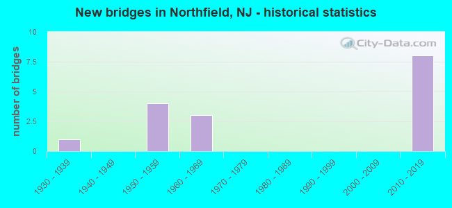
- New bridges - historical statistics
- 11930-1939
- 41950-1959
- 31960-1969
- 82010-2019
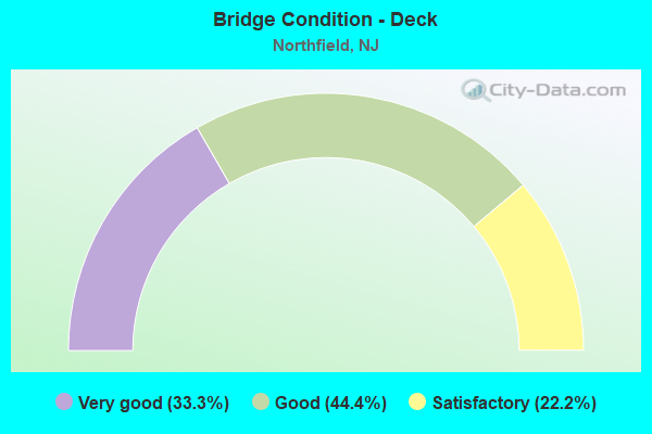
- Bridge Condition - Deck
- 33.3%Very good
- 44.4%Good
- 22.2%Satisfactory
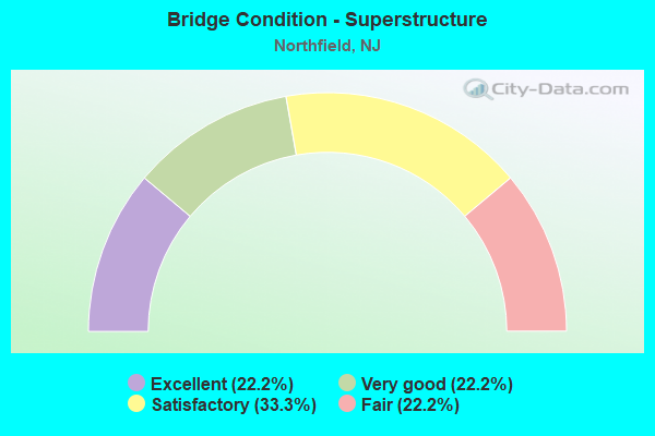
- Bridge Condition - Superstructure
- 22.2%Excellent
- 22.2%Very good
- 33.3%Satisfactory
- 22.2%Fair
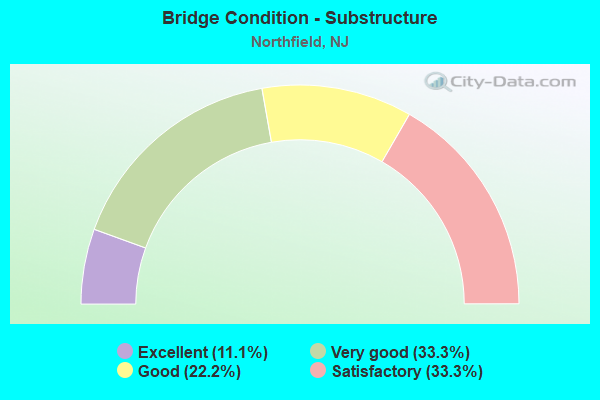
- Bridge Condition - Substructure
- 11.1%Excellent
- 33.3%Very good
- 22.2%Good
- 33.3%Satisfactory
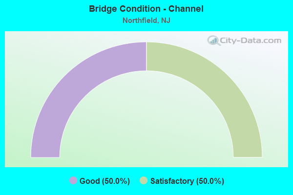
- Bridge Condition - Channel
- 50.0%Good
- 50.0%Satisfactory
Find on map >> Show street view
Structure Number: 1EH007, Location: 1.3 mile West NJ Rt 9 (Lat: 39.379419, Lng: -74.579769), Route carried "on" structure: County highway 662, Year Built: 1931, Year Reconstructed: 1980, Status: Open, Structure Length: 0.85m (2.79ft), Average Daily Traffic: 9,046 (year 2021), Truck Traffic: 3%, Average Future Daily Traffic: 10,855 (year 2041), Design Load: H 15, Features Intersected: PATCONG CREEK
Minimum Vertical Clearance: 30+ m (98+ ft), Kilometerpoint: 5.182, Lanes on structure: 2, Owner: County Highway Agency, Approaching Roadway Width: 7.6m (24.9ft), Skew: 3 degrees, Material/Design: Steel, Design/Construction: Stringer/Multi-beam, Number Of Spans In Main Unit: 1, Length of Maximum Span: 7.6m (24.9ft), Curb-To-Curb Width: 8.1m (26.6ft), Out-to-Out Width: 10.1m (33.1ft)
Condition: Deck: Satisfactory, Superstructure: Satisfactory, Substructure: Good, Channel: Good, Operating Rating: 40.8 metric tons, Method Used To Determine Operating Rating: Load Factor (LF), Inventory Rating: 24.5 metric tons, Method Used To Determine Inventory Rating: Load Factor (LF), Structural Evaluation: Equal to present minimum criteria, Deck Geometry: High priority of replacement, Waterway Adequacy: Superior to present desirable criteria, Approach Roadway Alignment: Equal to present desirable criteria, Length Of Structure Improvement: 0.85m (2.79ft), Designated Inspection Frequency: Every 24 months, Inspection Date: January 2021, Bridge Improvement Cost: $95,000, Roadway Improvement Cost: $9,000, Total Project Cost: $137,000 ( Estimate for 2021), Deck Structure Type: Concrete Cast-file-Place, Wearing Surface/Protective System: Wearing Surface: Bituminous
Find on map >> Show street view
Structure Number: 1EH065, Location: 1.55 MI S. OF US 322 & 40 (Lat: 39.400589, Lng: -74.598981), Route carried "on" structure: City street , Year Built: 1967, Status: Open, Structure Length: 0.73m (2.40ft), Average Daily Traffic: 3,524 (year 2021), Truck Traffic: 1%, Average Future Daily Traffic: 4,228 (year 2041), Design Load: HS 20, Features Intersected: MILL BRANCH, Facility Carried by Structure: RIDGE AVENUE
Minimum Vertical Clearance: 30+ m (98+ ft), Kilometerpoint: 4.056, Lanes on structure: 2, Owner: County Highway Agency, Approaching Roadway Width: 8.2m (26.9ft), Material/Design: Wood or Timber, Design/Construction: Stringer/Multi-beam, Number Of Spans In Main Unit: 2, Length of Maximum Span: 3.4m (11.2ft), Curb-To-Curb Width: 8.5m (27.9ft), Out-to-Out Width: 9.8m (32.2ft)
Condition: Deck: Very good, Superstructure: Satisfactory, Substructure: Satisfactory, Channel: Satisfactory, Operating Rating: 37.2 metric tons, Method Used To Determine Operating Rating: Allowable Stress (AS), Inventory Rating: 27.2 metric tons, Method Used To Determine Inventory Rating: Allowable Stress (AS), Structural Evaluation: Equal to present minimum criteria, Deck Geometry: Meets minimum limits, Waterway Adequacy: Equal to present desirable criteria, Approach Roadway Alignment: Equal to present desirable criteria, Designated Inspection Frequency: Every 24 months, Inspection Date: January 2021, Deck Structure Type: Wood or Timber, Wearing Surface/Protective System: Wearing Surface: Bituminous, Deck Protection: Other
Find on map >> Show street view
Structure Number: 350085, Location: 1.5 MI.FROM INTERCHG.7 (Lat: 39.423331, Lng: -74.573331), Route carried "on" structure: County highway 563, Year Built: 1963, Status: Open, Structure Length: 9.33m (30.61ft), Average Daily Traffic: 18,911 (year 2012), Truck Traffic: 4%, Average Future Daily Traffic: 27,180 (year 2032), Design Load: H 20, Features Intersected: ATLANTIC CITY EXPRESSWAY
Minimum Vertical Clearance: 30+ m (98+ ft), Kilometerpoint: 12.859, Lanes on structure: 2, Lanes under structure: 6, Base Highway Network: Yes, Owner: State Toll Authority, Maintenance Responsibility: Private, Approaching Roadway Width: 14.6m (47.9ft), Skew: 5 degrees, Material/Design: Steel, Design/Construction: Stringer/Multi-beam, Number Of Spans In Main Unit: 4, Length of Maximum Span: 32.0m (105.0ft), Curb or Sidewalk Widths: Left: 0.5m (1.6ft), Right: 1.2m (3.9ft), Curb-To-Curb Width: 14.6m (47.9ft), Out-to-Out Width: 17.0m (55.8ft)
Condition: Deck: Satisfactory, Superstructure: Fair, Substructure: Satisfactory, Operating Rating: 85.3 metric tons, Method Used To Determine Operating Rating: Load Factor (LF), Inventory Rating: 50.8 metric tons, Method Used To Determine Inventory Rating: Load Factor (LF), Structural Evaluation: Somewhat better than minimum adequacy, Deck Geometry: Superior to present desirable criteria, Underclear: Somewhat better than minimum adequacy, Approach Roadway Alignment: Equal to present minimum criteria, Length Of Structure Improvement: 9.30m (30.51ft), Designated Inspection Frequency: Every 24 months, Inspection Date: April 2020, Deck Structure Type: Concrete Cast-file-Place, Wearing Surface/Protective System: Wearing Surface: Monolithic Concrete
Find on map >> Show street view
Structure Number: 360345N, Location: 1 MI N OF BARGAINTWN POND (Lat: 39.379647, Lng: -74.578389), Route carried "on" structure: Other road GSP, Year Built: 1954, Status: Open, Structure Length: 2.26m (7.41ft), Average Daily Traffic: 34,198 (year 2021), Truck Traffic: 3%, Average Future Daily Traffic: 41,728 (year 2041), Design Load: HS 20, Features Intersected: MILL ROAD (CR 662)
Minimum Vertical Clearance: 30+ m (98+ ft), Kilometerpoint: 55.490, Lanes on structure: 3, Lanes under structure: 3, Base Highway Network: Yes, Toll: On toll road, Owner: State Toll Authority, Approaching Roadway Width: 12.2m (40.0ft), Skew: 4 degrees, Material/Design: Steel, Design/Construction: Stringer/Multi-beam, Number Of Spans In Main Unit: 1, Length of Maximum Span: 19.5m (64.0ft), Curb-To-Curb Width: 12.4m (40.7ft), Out-to-Out Width: 13.4m (44.0ft)
Condition: Deck: Good, Superstructure: Fair, Substructure: Good, Operating Rating: 51.5 metric tons, Method Used To Determine Operating Rating: Load and Resistance Factor Rating (LRFR) rating reported by rating factor(RF) method using HL-93 loadings, Inventory Rating: 39.5 metric tons, Method Used To Determine Inventory Rating: Load and Resistance Factor Rating (LRFR) rating reported by rating factor(RF) method using HL-93 loadings, Structural Evaluation: Somewhat better than minimum adequacy, Deck Geometry: High priority of replacement, Underclear: Meets minimum limits, Approach Roadway Alignment: Equal to present desirable criteria, Designated Inspection Frequency: Every 24 months, Inspection Date: April 2021, Deck Structure Type: Concrete Cast-file-Place, Wearing Surface/Protective System: Wearing Surface: Bituminous, Membrane: Preformed Fabric
Find on map >> Show street view
Structure Number: 360345S, Location: 1 MI N OF BARGAINTWN POND (Lat: 39.379500, Lng: -74.579200), Route carried "on" structure: Other road GSP, Year Built: 1954, Status: Open, Structure Length: 2.38m (7.81ft), Average Daily Traffic: 22,758 (year 2021), Truck Traffic: 3%, Average Future Daily Traffic: 27,770 (year 2041), Design Load: HS 20, Features Intersected: MILL ROAD (CR 662)
Minimum Vertical Clearance: 30+ m (98+ ft), Kilometerpoint: 55.490, Lanes on structure: 2, Lanes under structure: 2, Base Highway Network: Yes, Toll: On toll road, Owner: State Toll Authority, Approaching Roadway Width: 12.2m (40.0ft), Skew: 4 degrees, Material/Design: Steel, Design/Construction: Stringer/Multi-beam, Number Of Spans In Main Unit: 1, Length of Maximum Span: 20.7m (67.9ft), Curb-To-Curb Width: 12.4m (40.7ft), Out-to-Out Width: 13.4m (44.0ft)
Condition: Deck: Good, Superstructure: Satisfactory, Substructure: Satisfactory, Operating Rating: 60.3 metric tons, Method Used To Determine Operating Rating: Load and Resistance Factor Rating (LRFR) rating reported by rating factor(RF) method using HL-93 loadings, Inventory Rating: 46.3 metric tons, Method Used To Determine Inventory Rating: Load and Resistance Factor Rating (LRFR) rating reported by rating factor(RF) method using HL-93 loadings, Structural Evaluation: Equal to present minimum criteria, Deck Geometry: Better than present minimum criteria, Underclear: Meets minimum limits, Approach Roadway Alignment: Equal to present desirable criteria, Designated Inspection Frequency: Every 24 months, Inspection Date: April 2021, Deck Structure Type: Concrete Cast-file-Place, Wearing Surface/Protective System: Wearing Surface: Bituminous, Membrane: Preformed Fabric
Find on map >> Show street view
Structure Number: 370358T, Location: 0.4 MI S OF US 40&322 CIR (Lat: 39.395508, Lng: -74.562969), Route carried "on" structure: Ramp Other road GSP, Year Built: 2015, Status: Open, Structure Length: 4.69m (15.39ft), Average Daily Traffic: 5,773 (year 2021), Truck Traffic: 3%, Average Future Daily Traffic: 7,045 (year 2041), Design Load: HL 93, Features Intersected: GSP, Facility Carried by Structure: Int.36 SB Ent Ramp
Minimum Vertical Clearance: 30+ m (98+ ft), Kilometerpoint: 57.647, Lanes on structure: 1, Lanes under structure: 6, Toll: On toll road, Owner: State Toll Authority, Approaching Roadway Width: 7.9m (25.9ft), Material/Design: Steel continuous, Design/Construction: Stringer/Multi-beam, Number Of Spans In Main Unit: 2, Length of Maximum Span: 25.3m (83.0ft), Curb-To-Curb Width: 7.9m (25.9ft), Out-to-Out Width: 9.1m (29.9ft)
Condition: Deck: Very good, Superstructure: Very good, Substructure: Very good, Operating Rating: 54.8 metric tons, Method Used To Determine Operating Rating: Load and Resistance Factor Rating (LRFR) rating reported by rating factor(RF) method using HL-93 loadings, Inventory Rating: 42.1 metric tons, Method Used To Determine Inventory Rating: Load and Resistance Factor Rating (LRFR) rating reported by rating factor(RF) method using HL-93 loadings, Structural Evaluation: Equal to present desirable criteria, Deck Geometry: Equal to present desirable criteria, Underclear: Somewhat better than minimum adequacy, Approach Roadway Alignment: Equal to present desirable criteria, Designated Inspection Frequency: Every 24 months, Inspection Date: May 2021, Deck Structure Type: Concrete Cast-file-Place, Wearing Surface/Protective System: Wearing Surface: Monolithic Concrete, Deck Protection: Epoxy Coated Reinforcing
Find on map >> Show street view
Structure Number: 370361T, Location: 0.6 MI S OF RT40&322 CIR (Lat: 39.398358, Lng: -74.560869), Route carried "on" structure: Other road GSP, Year Built: 2016, Status: Open, Structure Length: 5.00m (16.40ft), Average Daily Traffic: 44,200 (year 2021), Truck Traffic: 3%, Average Future Daily Traffic: 59,600 (year 2041), Design Load: HL 93, Features Intersected: TILTON ROAD (CR 563)
Minimum Vertical Clearance: 30+ m (98+ ft), Kilometerpoint: 58.065, Lanes on structure: 8, Lanes under structure: 5, Base Highway Network: Yes, Toll: On toll road, Owner: State Toll Authority, Approaching Roadway Width: 43.9m (144.0ft), Skew: 34 degrees, Material/Design: Steel, Design/Construction: Stringer/Multi-beam, Number Of Spans In Main Unit: 1, Length of Maximum Span: 46.9m (153.9ft), Curb-To-Curb Width: 43.9m (144.0ft), Out-to-Out Width: 46.0m (150.9ft)
Condition: Deck: Good, Superstructure: Very good, Substructure: Excellent, Operating Rating: 63.2 metric tons, Method Used To Determine Operating Rating: Load and Resistance Factor Rating (LRFR) rating reported by rating factor(RF) method using HL-93 loadings, Inventory Rating: 48.6 metric tons, Method Used To Determine Inventory Rating: Load and Resistance Factor Rating (LRFR) rating reported by rating factor(RF) method using HL-93 loadings, Structural Evaluation: Equal to present desirable criteria, Deck Geometry: Superior to present desirable criteria, Underclear: Equal to present minimum criteria, Approach Roadway Alignment: Equal to present desirable criteria, Designated Inspection Frequency: Every 24 months, Inspection Date: July 2021, Deck Structure Type: Concrete Cast-file-Place, Wearing Surface/Protective System: Wearing Surface: Monolithic Concrete, Deck Protection: Epoxy Coated Reinforcing
Find on map >> Show street view
Structure Number: 370362T, Location: 0.5 MI S OF RT40&322 CIR (Lat: 39.400139, Lng: -74.559731), Route carried "on" structure: Other road GSP, Year Built: 2016, Status: Open, Structure Length: 4.69m (15.39ft), Average Daily Traffic: 49,495 (year 2021), Truck Traffic: 3%, Average Future Daily Traffic: 60,394 (year 2041), Design Load: HL 93, Features Intersected: US RT 40&322 (BL HRS PK)
Minimum Vertical Clearance: 30+ m (98+ ft), Kilometerpoint: 58.258, Lanes on structure: 7, Lanes under structure: 4, Base Highway Network: Yes, Toll: On toll road, Owner: State Toll Authority, Approaching Roadway Width: 40.2m (131.9ft), Skew: 30 degrees, Material/Design: Steel continuous, Design/Construction: Stringer/Multi-beam, Number Of Spans In Main Unit: 2, Length of Maximum Span: 18.6m (61.0ft), Curb-To-Curb Width: 40.2m (131.9ft), Out-to-Out Width: 42.3m (138.8ft)
Condition: Deck: Very good, Superstructure: Excellent, Substructure: Very good, Operating Rating: 52.2 metric tons, Method Used To Determine Operating Rating: Load and Resistance Factor Rating (LRFR) rating reported by rating factor(RF) method using HL-93 loadings, Inventory Rating: 40.2 metric tons, Method Used To Determine Inventory Rating: Load and Resistance Factor Rating (LRFR) rating reported by rating factor(RF) method using HL-93 loadings, Structural Evaluation: Equal to present desirable criteria, Deck Geometry: Superior to present desirable criteria, Underclear: Better than present minimum criteria, Approach Roadway Alignment: Equal to present desirable criteria, Designated Inspection Frequency: Every 24 months, Inspection Date: July 2021, Deck Structure Type: Concrete Cast-file-Place, Wearing Surface/Protective System: Wearing Surface: Monolithic Concrete, Deck Protection: Epoxy Coated Reinforcing
Find on map >> Show street view
Structure Number: 370366T, Location: 0.6 MI S OF GSP&ACE JCT (Lat: 39.404919, Lng: -74.557239), Route carried "on" structure: Other road GSP, Year Built: 2016, Status: Open, Structure Length: 2.19m (7.19ft), Average Daily Traffic: 53,701 (year 2021), Truck Traffic: 3%, Average Future Daily Traffic: 65,526 (year 2041), Design Load: HL 93, Features Intersected: WASHINGTON AVE (CR 608)
Minimum Vertical Clearance: 30+ m (98+ ft), Kilometerpoint: 58.886, Lanes on structure: 8, Lanes under structure: 3, Base Highway Network: Yes, Toll: On toll road, Owner: State Toll Authority, Approaching Roadway Width: 43.9m (144.0ft), Skew: 31 degrees, Material/Design: Steel, Design/Construction: Stringer/Multi-beam, Number Of Spans In Main Unit: 1, Length of Maximum Span: 21.3m (69.9ft), Curb-To-Curb Width: 43.9m (144.0ft), Out-to-Out Width: 46.0m (150.9ft)
Condition: Deck: Good, Superstructure: Excellent, Substructure: Very good, Operating Rating: 77.1 metric tons, Method Used To Determine Operating Rating: Load and Resistance Factor Rating (LRFR) rating reported by rating factor(RF) method using HL-93 loadings, Inventory Rating: 59.3 metric tons, Method Used To Determine Inventory Rating: Load and Resistance Factor Rating (LRFR) rating reported by rating factor(RF) method using HL-93 loadings, Structural Evaluation: Equal to present desirable criteria, Deck Geometry: Superior to present desirable criteria, Underclear: Somewhat better than minimum adequacy, Approach Roadway Alignment: Superior to present desirable criteria, Designated Inspection Frequency: Every 24 months, Inspection Date: July 2021, Deck Structure Type: Concrete Cast-file-Place, Wearing Surface/Protective System: Wearing Surface: Monolithic Concrete, Deck Protection: Epoxy Coated Reinforcing
Find on map >> Show street view
Structure Number: 350085, Location: 1.5 MI.FROM INTERCHG.7 (Lat: 39.423331, Lng: -74.573331), Route carried "under" structure: Other road ACE, Year Built: 1963, Structure Length: 0. m, Average Daily Traffic: 42,998 (year 2012), Truck Traffic: 5%, Features Intersected: ATLANTIC CITY EXPRESSWAY, Facility Carried by Structure: TILTON RD(CO.563)
Minimum Vertical Clearance: 4.36m (14.30ft), Kilometerpoint: 13.679, Lanes on structure: 2, Lanes under structure: 5, Material/Design: Steel, Design/Construction: Stringer/Multi-beam, Length of Maximum Span: 32.0m (105.0ft)
Find on map >> Show street view
Structure Number: 360345N, Location: 1 MI N OF BARGAINTWN POND (Lat: 39.379647, Lng: -74.578389), Route carried "under" structure: County highway 662, Year Built: 1954, Structure Length: 0. m, Average Daily Traffic: 10,011 (year 2021), Truck Traffic: 3%, Features Intersected: MILL ROAD (CR 662), Facility Carried by Structure: GSP NB
Minimum Vertical Clearance: 4.55m (14.93ft), Kilometerpoint: 5.295, Lanes on structure: 3, Lanes under structure: 2, Material/Design: Steel, Design/Construction: Stringer/Multi-beam, Length of Maximum Span: 19.5m (64.0ft)
Find on map >> Show street view
Structure Number: 360345S, Location: 1 MI N OF BARGAINTWN POND (Lat: 39.379500, Lng: -74.579200), Route carried "under" structure: County highway 662, Year Built: 1954, Structure Length: 0. m, Average Daily Traffic: 10,011 (year 2021), Truck Traffic: 3%, Features Intersected: MILL ROAD (CR 662), Facility Carried by Structure: GSP SB
Minimum Vertical Clearance: 4.62m (15.16ft), Kilometerpoint: 5.230, Lanes on structure: 2, Lanes under structure: 2, Material/Design: Steel, Design/Construction: Stringer/Multi-beam, Length of Maximum Span: 20.7m (67.9ft)
Find on map >> Show street view
Structure Number: 370358T, Location: 0.4 MI S OF US 40&322 CIR (Lat: 39.395508, Lng: -74.562969), Route carried "under" structure: Other road GSP, Year Built: 2015, Structure Length: 0. m, Average Daily Traffic: 44,640 (year 2021), Truck Traffic: 3%, Features Intersected: GSP, Facility Carried by Structure: Int.36 SB Ent Ramp
Minimum Vertical Clearance: 5.03m (16.50ft), Kilometerpoint: 57.647, Lanes on structure: 1, Lanes under structure: 6, Toll: On toll road, Material/Design: Steel continuous, Design/Construction: Stringer/Multi-beam, Length of Maximum Span: 25.3m (83.0ft)
Find on map >> Show street view
Structure Number: 370361T, Location: 0.6 MI S OF RT40&322 CIR (Lat: 39.398358, Lng: -74.560869), Route carried "under" structure: County highway 563, Year Built: 2016, Structure Length: 0. m, Average Daily Traffic: 28,914 (year 2021), Truck Traffic: 4%, Features Intersected: TILTON ROAD (CR 563), Facility Carried by Structure: GSP
Minimum Vertical Clearance: 4.82m (15.81ft), Kilometerpoint: 9.849, Lanes on structure: 8, Lanes under structure: 5, Material/Design: Steel, Design/Construction: Stringer/Multi-beam, Length of Maximum Span: 46.9m (153.9ft)
Find on map >> Show street view
Structure Number: 370362T, Location: 0.5 MI S OF RT40&322 CIR (Lat: 39.400139, Lng: -74.559731), Route carried "under" structure: US 40, Year Built: 2016, Structure Length: 0. m, Average Daily Traffic: 42,403 (year 2021), Truck Traffic: 4%, Features Intersected: US RT 40&322 (BL HRS PK), Facility Carried by Structure: GSP
Minimum Vertical Clearance: 5.49m (18.01ft), Kilometerpoint: 92.473, Lanes on structure: 7, Lanes under structure: 4, Material/Design: Steel continuous, Design/Construction: Stringer/Multi-beam, Length of Maximum Span: 18.6m (61.0ft)
Find on map >> Show street view
Structure Number: 370366T, Location: 0.6 MI S OF GSP&ACE JCT (Lat: 39.404919, Lng: -74.557239), Route carried "under" structure: County highway 608, Year Built: 2016, Structure Length: 0. m, Average Daily Traffic: 13,650 (year 2021), Truck Traffic: 4%, Features Intersected: WASHINGTON AVE (CR 608), Facility Carried by Structure: GSP
Minimum Vertical Clearance: 4.65m (15.26ft), Kilometerpoint: 3.814, Lanes on structure: 8, Lanes under structure: 3, Material/Design: Steel, Design/Construction: Stringer/Multi-beam, Length of Maximum Span: 21.3m (69.9ft)