Bridge Statistics for Olivehurst, California (CA)
Condition, Traffic, Stress, Structural Evaluation, Project Costs
- National Bridge Inventory (NBI) Statistics
- 26Number of bridges
- 279ft / 84.9mTotal length
- 277,090Total average daily traffic
- 26,231Total average daily truck traffic
- National Bridge Inventory (NBI) Registered Bridges for Olivehurst
- No street view available for this location
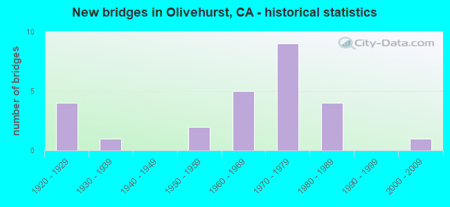
- New bridges - historical statistics
- 41920-1929
- 11930-1939
- 21950-1959
- 51960-1969
- 91970-1979
- 41980-1989
- 12000-2009
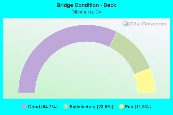
- Bridge Condition - Deck
- 64.7%Good
- 23.5%Satisfactory
- 11.8%Fair
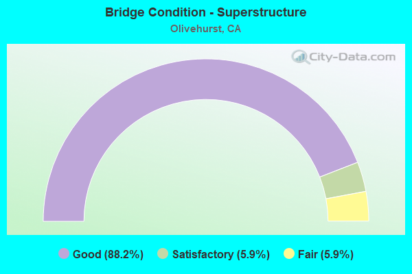
- Bridge Condition - Superstructure
- 88.2%Good
- 5.9%Satisfactory
- 5.9%Fair
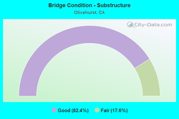
- Bridge Condition - Substructure
- 82.4%Good
- 17.6%Fair
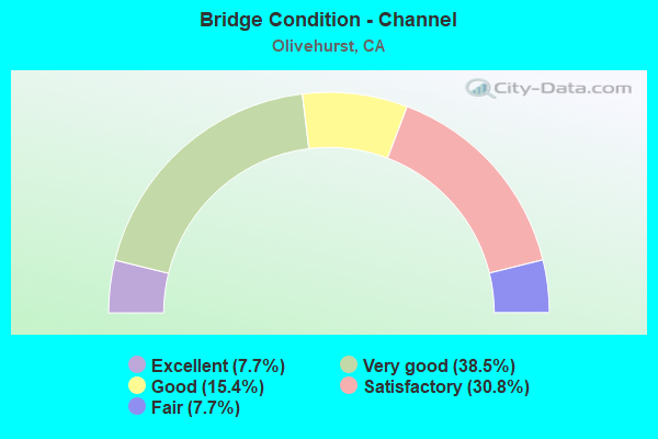
- Bridge Condition - Channel
- 7.7%Excellent
- 38.5%Very good
- 15.4%Good
- 30.8%Satisfactory
- 7.7%Fair
Find on map >> Show street view
Structure Number: 16 0036, Location: 03-YUB-070-R9.28 (Lat: 39.102289, Lng: -121.550625), Route carried "on" structure: County highway , Year Built: 1956, Status: Open, Structure Length: 3.63m (11.91ft), Average Daily Traffic: 14,000 (year 2009), Truck Traffic: 10%, Average Future Daily Traffic: 8,782 (year 2040), Design Load: HS 20, Features Intersected: STATE ROUTE 70, Facility Carried by Structure: OLIVEHURST AVE
Minimum Vertical Clearance: 30+ m (98+ ft), Kilometerpoint: 0.000, Lanes on structure: 2, Lanes under structure: 5, Owner: State Highway Agency, Approaching Roadway Width: 8.5m (27.9ft), Skew: 2 degrees, Material/Design: Concrete continuous, Design/Construction: Tee Beam, Number Of Spans In Main Unit: 2, Length of Maximum Span: 18.0m (59.1ft), Curb or Sidewalk Widths: Left: 1.6m (5.2ft), Right: 1.6m (5.2ft), Curb-To-Curb Width: 8.5m (27.9ft), Out-to-Out Width: 12.7m (41.7ft)
Condition: Deck: Satisfactory, Superstructure: Good, Substructure: Good, Operating Rating: 37.3 metric tons, Method Used To Determine Operating Rating: Load and Resistance Factor Rating (LRFR) rating reported by rating factor(RF) method using HL-93 loadings, Inventory Rating: 26.6 metric tons, Method Used To Determine Inventory Rating: Load and Resistance Factor Rating (LRFR) rating reported by rating factor(RF) method using HL-93 loadings, Structural Evaluation: Equal to present minimum criteria, Deck Geometry: High priority of replacement, Underclear: Meets minimum limits, Approach Roadway Alignment: Equal to present desirable criteria, Designated Inspection Frequency: Every 24 months, Inspection Date: Febuary 2022, Deck Structure Type: Concrete Cast-file-Place
Find on map >> Show street view
Structure Number: 16 0041, Location: 03-YUB-070-R7.34 (Lat: 39.077281, Lng: -121.541628), Route carried "on" structure: County highway , Year Built: 1967, Status: Open, Structure Length: 4.94m (16.21ft), Average Daily Traffic: 8,100 (year 2009), Truck Traffic: 10%, Average Future Daily Traffic: 8,782 (year 2040), Design Load: HS 20, Features Intersected: STATE ROUTE 70, Facility Carried by Structure: MCGOWAN ROAD
Minimum Vertical Clearance: 30+ m (98+ ft), Kilometerpoint: 0.000, Lanes on structure: 2, Lanes under structure: 4, Owner: State Highway Agency, Approaching Roadway Width: 9.8m (32.2ft), Material/Design: Concrete continuous, Design/Construction: Box Beam or Girders - Multiple, Number Of Spans In Main Unit: 2, Length of Maximum Span: 24.4m (80.1ft), Curb or Sidewalk Widths: Left: 1.5m (4.9ft), Right: 1.5m (4.9ft), Curb-To-Curb Width: 9.8m (32.2ft), Out-to-Out Width: 13.8m (45.3ft)
Condition: Deck: Satisfactory, Superstructure: Satisfactory, Substructure: Good, Operating Rating: 41.1 metric tons, Method Used To Determine Operating Rating: Load and Resistance Factor Rating (LRFR) rating reported by rating factor(RF) method using HL-93 loadings, Inventory Rating: 31.8 metric tons, Method Used To Determine Inventory Rating: Load and Resistance Factor Rating (LRFR) rating reported by rating factor(RF) method using HL-93 loadings, Structural Evaluation: Equal to present minimum criteria, Deck Geometry: Meets minimum limits, Underclear: High priority of corrective action, Approach Roadway Alignment: Better than present minimum criteria, Designated Inspection Frequency: Every 24 months, Inspection Date: Febuary 2022, Deck Structure Type: Concrete Cast-file-Place
Find on map >> Show street view
Structure Number: 16 0042L, Location: 03-YUB-065-R9.16 (Lat: 39.090831, Lng: -121.540144), Route carried "on" structure: State highway 65, Year Built: 1967, Status: Open, Structure Length: 6.25m (20.51ft), Average Daily Traffic: 12,000 (year 2010), Truck Traffic: 7%, Average Future Daily Traffic: 25,094 (year 2041), Design Load: HS 20, Features Intersected: STATE ROUTE 70 NB
Minimum Vertical Clearance: 30+ m (98+ ft), Kilometerpoint: 9.160, Lanes on structure: 2, Lanes under structure: 2, Base Highway Network: Yes (, Subroute: 1), Owner: State Highway Agency, Approaching Roadway Width: 11.9m (39.0ft), Skew: 4 degrees, Material/Design: Concrete continuous, Design/Construction: Box Beam or Girders - Multiple, Number Of Spans In Main Unit: 3, Length of Maximum Span: 29.7m (97.4ft), Curb-To-Curb Width: 11.9m (39.0ft), Out-to-Out Width: 12.5m (41.0ft)
Condition: Deck: Good, Superstructure: Good, Substructure: Good, Operating Rating: 47.0 metric tons, Method Used To Determine Operating Rating: Load and Resistance Factor Rating (LRFR) rating reported by rating factor(RF) method using HL-93 loadings, Inventory Rating: 33.7 metric tons, Method Used To Determine Inventory Rating: Load and Resistance Factor Rating (LRFR) rating reported by rating factor(RF) method using HL-93 loadings, Structural Evaluation: Better than present minimum criteria, Deck Geometry: Equal to present minimum criteria, Underclear: Somewhat better than minimum adequacy, Approach Roadway Alignment: Equal to present minimum criteria, Designated Inspection Frequency: Every 48 months, Inspection Date: September 2019, Deck Structure Type: Concrete Cast-file-Place, Wearing Surface/Protective System: Wearing Surface: Integral Concrete
Find on map >> Show street view
Structure Number: 16 0043, Location: 03-YUB-070-R6.04 (Lat: 39.058697, Lng: -121.543883), Route carried "on" structure: State highway 70, Year Built: 1967, Status: Open, Structure Length: 0.67m (2.20ft), Average Daily Traffic: 17,200 (year 2009), Truck Traffic: 7%, Average Future Daily Traffic: 35,005 (year 2042), Features Intersected: CLARK DIVERSION CANAL
Minimum Vertical Clearance: 30+ m (98+ ft), Kilometerpoint: 6.040, Lanes on structure: 4, Base Highway Network: Yes (, Subroute: 1), Owner: State Highway Agency, Approaching Roadway Width: 12.2m (40.0ft), Material/Design: Concrete continuous, Design/Construction: Culvert, Number Of Spans In Main Unit: 2, Length of Maximum Span: 3.0m (9.8ft)
Condition: Channel: Excellent, Culverts: Good, Operating Rating: 54.1 metric tons, Method Used To Determine Operating Rating: Field evaluation and documented engineering judgment, Inventory Rating: 32.4 metric tons, Method Used To Determine Inventory Rating: Field evaluation and documented engineering judgment, Structural Evaluation: Better than present minimum criteria, Waterway Adequacy: Better than present minimum criteria, Approach Roadway Alignment: Equal to present desirable criteria, Designated Inspection Frequency: Every 48 months, Inspection Date: Febuary 2020
Find on map >> Show street view
Structure Number: 16 0044, Location: 03-YUB-065-R6.88 (Lat: 39.064625, Lng: -121.514192), Route carried "on" structure: County highway F066, Year Built: 1971, Status: Open, Structure Length: 8.09m (26.54ft), Average Daily Traffic: 1,200 (year 2010), Truck Traffic: 10%, Average Future Daily Traffic: 1,476 (year 2041), Design Load: HS 20, Features Intersected: STATE ROUTE 65, Facility Carried by Structure: FORTY MILE ROAD
Minimum Vertical Clearance: 30+ m (98+ ft), Kilometerpoint: 0.000, Lanes on structure: 2, Lanes under structure: 4, Owner: State Highway Agency, Approaching Roadway Width: 12.2m (40.0ft), Skew: 2 degrees, Material/Design: Prestressed concrete continuous, Design/Construction: Box Beam or Girders - Multiple, Number Of Spans In Main Unit: 2, Length of Maximum Span: 40.2m (131.9ft), Curb or Sidewalk Widths: Left: 1.5m (4.9ft), Right: 0.0m, Curb-To-Curb Width: 12.2m (40.0ft), Out-to-Out Width: 14.3m (46.9ft)
Condition: Deck: Good, Superstructure: Good, Substructure: Good, Operating Rating: 60.9 metric tons, Method Used To Determine Operating Rating: Load and Resistance Factor Rating (LRFR) rating reported by rating factor(RF) method using HL-93 loadings, Inventory Rating: 40.5 metric tons, Method Used To Determine Inventory Rating: Load and Resistance Factor Rating (LRFR) rating reported by rating factor(RF) method using HL-93 loadings, Structural Evaluation: Better than present minimum criteria, Deck Geometry: Better than present minimum criteria, Underclear: Better than present minimum criteria, Approach Roadway Alignment: Equal to present desirable criteria, Designated Inspection Frequency: Every 24 months, Inspection Date: September 2021, Deck Structure Type: Concrete Cast-file-Place
Find on map >> Show street view
Structure Number: 16 0045L, Location: 03-YUB-065-R7.44 (Lat: 39.070458, Lng: -121.521664), Route carried "on" structure: State highway 65, Year Built: 1971, Status: Open, Structure Length: 5.78m (18.96ft), Average Daily Traffic: 7,200 (year 2010), Truck Traffic: 9%, Average Future Daily Traffic: 8,478 (year 2043), Design Load: HS 20, Features Intersected: HUTCHINSON CREEK
Minimum Vertical Clearance: 30+ m (98+ ft), Kilometerpoint: 7.440, Lanes on structure: 2, Base Highway Network: Yes (, Subroute: 1), Owner: State Highway Agency, Approaching Roadway Width: 11.9m (39.0ft), Skew: 4 degrees, Material/Design: Concrete continuous, Design/Construction: Tee Beam, Number Of Spans In Main Unit: 4, Length of Maximum Span: 14.2m (46.6ft), Curb-To-Curb Width: 11.9m (39.0ft), Out-to-Out Width: 12.5m (41.0ft)
Condition: Deck: Good, Superstructure: Good, Substructure: Good, Channel: Very good, Operating Rating: 44.4 metric tons, Method Used To Determine Operating Rating: Load and Resistance Factor Rating (LRFR) rating reported by rating factor(RF) method using HL-93 loadings, Inventory Rating: 34.3 metric tons, Method Used To Determine Inventory Rating: Load and Resistance Factor Rating (LRFR) rating reported by rating factor(RF) method using HL-93 loadings, Structural Evaluation: Better than present minimum criteria, Deck Geometry: Better than present minimum criteria, Waterway Adequacy: Equal to present desirable criteria, Approach Roadway Alignment: Equal to present desirable criteria, Designated Inspection Frequency: Every 48 months, Inspection Date: September 2021, Deck Structure Type: Concrete Cast-file-Place
Find on map >> Show street view
Structure Number: 16 0045R, Location: 03-YUB-065-R7.42 (Lat: 39.070400, Lng: -121.521031), Route carried "on" structure: State highway 65, Year Built: 1971, Status: Open, Structure Length: 5.84m (19.16ft), Average Daily Traffic: 8,100 (year 2009), Average Future Daily Traffic: 17,909 (year 2043), Design Load: HS 20, Features Intersected: HUTCHINSON CREEK
Minimum Vertical Clearance: 30+ m (98+ ft), Kilometerpoint: 7.420, Lanes on structure: 2, Base Highway Network: Yes (, Subroute: 1), Owner: State Highway Agency, Approaching Roadway Width: 11.9m (39.0ft), Skew: 4 degrees, Material/Design: Concrete continuous, Design/Construction: Tee Beam, Number Of Spans In Main Unit: 4, Length of Maximum Span: 14.4m (47.2ft), Curb-To-Curb Width: 11.9m (39.0ft), Out-to-Out Width: 12.5m (41.0ft)
Condition: Deck: Good, Superstructure: Good, Substructure: Good, Channel: Very good, Operating Rating: 44.1 metric tons, Method Used To Determine Operating Rating: Load and Resistance Factor Rating (LRFR) rating reported by rating factor(RF) method using HL-93 loadings, Inventory Rating: 34.0 metric tons, Method Used To Determine Inventory Rating: Load and Resistance Factor Rating (LRFR) rating reported by rating factor(RF) method using HL-93 loadings, Structural Evaluation: Better than present minimum criteria, Deck Geometry: Better than present minimum criteria, Waterway Adequacy: Equal to present desirable criteria, Approach Roadway Alignment: Equal to present desirable criteria, Length Of Structure Improvement: 5.85m (19.19ft), Designated Inspection Frequency: Every 48 months, Inspection Date: September 2021, Deck Structure Type: Concrete Cast-file-Place
Find on map >> Show street view
Structure Number: 16 0046L, Location: 03-YUB-065-R7.61 (Lat: 39.072422, Lng: -121.523628), Route carried "on" structure: State highway 65, Year Built: 1971, Status: Open, Structure Length: 4.93m (16.17ft), Average Daily Traffic: 15,000 (year 2010), Truck Traffic: 9%, Average Future Daily Traffic: 24,680 (year 2041), Design Load: HS 20, Features Intersected: REEDS CREEK
Minimum Vertical Clearance: 30+ m (98+ ft), Kilometerpoint: 7.610, Lanes on structure: 2, Base Highway Network: Yes (, Subroute: 1), Owner: State Highway Agency, Approaching Roadway Width: 11.9m (39.0ft), Material/Design: Concrete continuous, Design/Construction: Tee Beam, Number Of Spans In Main Unit: 4, Length of Maximum Span: 13.4m (44.0ft), Curb-To-Curb Width: 11.9m (39.0ft), Out-to-Out Width: 12.5m (41.0ft)
Condition: Deck: Fair, Superstructure: Good, Substructure: Good, Channel: Very good, Operating Rating: 37.6 metric tons, Method Used To Determine Operating Rating: Load and Resistance Factor Rating (LRFR) rating reported by rating factor(RF) method using HL-93 loadings, Inventory Rating: 26.9 metric tons, Method Used To Determine Inventory Rating: Load and Resistance Factor Rating (LRFR) rating reported by rating factor(RF) method using HL-93 loadings, Structural Evaluation: Equal to present minimum criteria, Deck Geometry: Better than present minimum criteria, Waterway Adequacy: Equal to present desirable criteria, Approach Roadway Alignment: Equal to present desirable criteria, Designated Inspection Frequency: Every 24 months, Inspection Date: September 2021, Deck Structure Type: Concrete Cast-file-Place
Find on map >> Show street view
Structure Number: 16 0046R, Location: 03-YUB-065-R7.61 (Lat: 39.072614, Lng: -121.523278), Route carried "on" structure: State highway 65, Year Built: 1971, Status: Open, Structure Length: 4.93m (16.17ft), Average Daily Traffic: 15,000 (year 2010), Truck Traffic: 9%, Average Future Daily Traffic: 24,516 (year 2041), Design Load: HS 20, Features Intersected: REEDS CREEK
Minimum Vertical Clearance: 30+ m (98+ ft), Kilometerpoint: 7.610, Lanes on structure: 2, Base Highway Network: Yes (, Subroute: 1), Owner: State Highway Agency, Approaching Roadway Width: 11.9m (39.0ft), Material/Design: Concrete continuous, Design/Construction: Tee Beam, Number Of Spans In Main Unit: 4, Length of Maximum Span: 13.4m (44.0ft), Curb-To-Curb Width: 11.9m (39.0ft), Out-to-Out Width: 12.5m (41.0ft)
Condition: Deck: Satisfactory, Superstructure: Good, Substructure: Good, Channel: Very good, Operating Rating: 37.6 metric tons, Method Used To Determine Operating Rating: Load and Resistance Factor Rating (LRFR) rating reported by rating factor(RF) method using HL-93 loadings, Inventory Rating: 26.9 metric tons, Method Used To Determine Inventory Rating: Load and Resistance Factor Rating (LRFR) rating reported by rating factor(RF) method using HL-93 loadings, Structural Evaluation: Equal to present minimum criteria, Deck Geometry: Better than present minimum criteria, Waterway Adequacy: Equal to present desirable criteria, Approach Roadway Alignment: Equal to present desirable criteria, Designated Inspection Frequency: Every 24 months, Inspection Date: September 2021, Deck Structure Type: Concrete Cast-file-Place
Find on map >> Show street view
Structure Number: 16 0047, Location: 03-YUB-065-R8.03 (Lat: 39.077456, Lng: -121.528269), Route carried "on" structure: County highway , Year Built: 1971, Status: Open, Structure Length: 9.04m (29.66ft), Average Daily Traffic: 8,000 (year 2010), Truck Traffic: 10%, Average Future Daily Traffic: 13,711 (year 2041), Design Load: HS 20, Features Intersected: STATE ROUTE 65, Facility Carried by Structure: MCGOWAN ROAD
Minimum Vertical Clearance: 30+ m (98+ ft), Kilometerpoint: 0.000, Lanes on structure: 2, Lanes under structure: 4, Owner: State Highway Agency, Approaching Roadway Width: 15.2m (49.9ft), Skew: 3 degrees, Material/Design: Prestressed concrete continuous, Design/Construction: Box Beam or Girders - Multiple, Number Of Spans In Main Unit: 2, Length of Maximum Span: 45.0m (147.6ft), Curb or Sidewalk Widths: Left: 1.5m (4.9ft), Right: 1.5m (4.9ft), Curb-To-Curb Width: 12.2m (40.0ft), Out-to-Out Width: 15.8m (51.8ft)
Condition: Deck: Good, Superstructure: Good, Substructure: Good, Operating Rating: 46.7 metric tons, Method Used To Determine Operating Rating: Load and Resistance Factor Rating (LRFR) rating reported by rating factor(RF) method using HL-93 loadings, Inventory Rating: 32.7 metric tons, Method Used To Determine Inventory Rating: Load and Resistance Factor Rating (LRFR) rating reported by rating factor(RF) method using HL-93 loadings, Structural Evaluation: Better than present minimum criteria, Deck Geometry: Somewhat better than minimum adequacy, Underclear: Equal to present minimum criteria, Approach Roadway Alignment: Equal to present desirable criteria, Designated Inspection Frequency: Every 24 months, Inspection Date: September 2021, Deck Structure Type: Concrete Cast-file-Place
Find on map >> Show street view
Structure Number: 16 0048, Location: 03-YUB-065-R6.32 (Lat: 39.059736, Lng: -121.506036), Route carried "on" structure: State highway 65, Year Built: 1971, Status: Open, Structure Length: 0.70m (2.30ft), Average Daily Traffic: 14,000 (year 2010), Truck Traffic: 9%, Average Future Daily Traffic: 16,269 (year 2037), Features Intersected: KIMBALL CREEK
Minimum Vertical Clearance: 30+ m (98+ ft), Kilometerpoint: 6.320, Lanes on structure: 4, Base Highway Network: Yes (, Subroute: 1), Owner: State Highway Agency, Approaching Roadway Width: 49.4m (162.1ft), Material/Design: Concrete continuous, Design/Construction: Culvert, Number Of Spans In Main Unit: 2, Length of Maximum Span: 3.0m (9.8ft)
Condition: Channel: Very good, Culverts: Good, Operating Rating: 54.1 metric tons, Method Used To Determine Operating Rating: Field evaluation and documented engineering judgment, Inventory Rating: 32.4 metric tons, Method Used To Determine Inventory Rating: Field evaluation and documented engineering judgment, Structural Evaluation: Better than present minimum criteria, Waterway Adequacy: Equal to present desirable criteria, Approach Roadway Alignment: Equal to present desirable criteria, Designated Inspection Frequency: Every 48 months, Inspection Date: September 2019
Find on map >> Show street view
Structure Number: 16 0049, Location: 03-YUB-070-R10.16 (Lat: 39.113208, Lng: -121.559564), Route carried "on" structure: County highway , Year Built: 1980, Status: Open, Structure Length: 7.68m (25.20ft), Average Daily Traffic: 2,000 (year 2007), Truck Traffic: 10%, Average Future Daily Traffic: 4,275 (year 2040), Design Load: HS 20+Mod, Features Intersected: STATE ROUTE 70, Facility Carried by Structure: ERLE ROAD
Minimum Vertical Clearance: 30+ m (98+ ft), Kilometerpoint: 0.000, Lanes on structure: 2, Lanes under structure: 4, Owner: State Highway Agency, Approaching Roadway Width: 15.8m (51.8ft), Skew: 3 degrees, Material/Design: Prestressed concrete continuous, Design/Construction: Box Beam or Girders - Multiple, Number Of Spans In Main Unit: 2, Length of Maximum Span: 41.1m (134.8ft), Curb or Sidewalk Widths: Left: 1.5m (4.9ft), Right: 0.0m, Curb-To-Curb Width: 15.8m (51.8ft), Out-to-Out Width: 18.2m (59.7ft)
Condition: Deck: Satisfactory, Superstructure: Good, Substructure: Good, Operating Rating: 54.1 metric tons, Method Used To Determine Operating Rating: Assigned rating based on Load Factor Design (LFD) reported in metric tons, Inventory Rating: 32.4 metric tons, Method Used To Determine Inventory Rating: Assigned rating based on Load Factor Design (LFD) reported in metric tons, Structural Evaluation: Better than present minimum criteria, Deck Geometry: Superior to present desirable criteria, Underclear: Somewhat better than minimum adequacy, Approach Roadway Alignment: Equal to present desirable criteria, Designated Inspection Frequency: Every 24 months, Inspection Date: Febuary 2022, Deck Structure Type: Concrete Cast-file-Place
Find on map >> Show street view
Structure Number: 16C0057, Location: .7 MI SE/O OSTROM RD (Lat: 39.062150, Lng: -121.502294), Route carried "on" structure: County highway , Year Built: 1925, Year Reconstructed: 1935, Status: Open, Structure Length: 2.35m (7.71ft), Average Daily Traffic: 230 (year 2011), Truck Traffic: 5%, Average Future Daily Traffic: 762 (year 2040), Features Intersected: KIMBALL CREEK, Facility Carried by Structure: RANCHO RD
Minimum Vertical Clearance: 30+ m (98+ ft), Kilometerpoint: 0.000, Lanes on structure: 2, Owner: County Highway Agency, Approaching Roadway Width: 8.5m (27.9ft), Material/Design: Concrete continuous, Design/Construction: Slab, Number Of Spans In Main Unit: 5, Length of Maximum Span: 4.6m (15.1ft), Curb or Sidewalk Widths: Left: 0.3m (1.0ft), Right: 0.3m (1.0ft), Curb-To-Curb Width: 10.3m (33.8ft), Out-to-Out Width: 11.5m (37.7ft)
Condition: Deck: Good, Superstructure: Good, Substructure: Fair, Channel: Satisfactory, Operating Rating: 26.9 metric tons, Method Used To Determine Operating Rating: Field evaluation and documented engineering judgment, Inventory Rating: 16.2 metric tons, Method Used To Determine Inventory Rating: Field evaluation and documented engineering judgment, Structural Evaluation: Somewhat better than minimum adequacy, Deck Geometry: Better than present minimum criteria, Waterway Adequacy: Equal to present minimum criteria, Approach Roadway Alignment: Equal to present desirable criteria, Designated Inspection Frequency: Every 24 months, Inspection Date: August 2020, Deck Structure Type: Concrete Cast-file-Place, Wearing Surface/Protective System: Wearing Surface: Bituminous
Find on map >> Show street view
Structure Number: 16C0058, Location: .3 MI NW/O OSTROM RD (Lat: 39.071519, Lng: -121.515744), Route carried "on" structure: County highway , Year Built: 1925, Year Reconstructed: 1935, Status: Open, Structure Length: 3.08m (10.10ft), Average Daily Traffic: 1,700 (year 2013), Truck Traffic: 5%, Average Future Daily Traffic: 762 (year 2040), Features Intersected: HUTCHINSON CREEK, Facility Carried by Structure: RANCHO RD
Minimum Vertical Clearance: 30+ m (98+ ft), Kilometerpoint: 0.000, Lanes on structure: 2, Owner: County Highway Agency, Approaching Roadway Width: 8.8m (28.9ft), Material/Design: Concrete continuous, Design/Construction: Slab, Number Of Spans In Main Unit: 6, Length of Maximum Span: 5.2m (17.1ft), Curb or Sidewalk Widths: Left: 0.3m (1.0ft), Right: 0.3m (1.0ft), Curb-To-Curb Width: 10.3m (33.8ft), Out-to-Out Width: 11.5m (37.7ft)
Condition: Deck: Good, Superstructure: Good, Substructure: Good, Channel: Satisfactory, Operating Rating: 26.9 metric tons, Method Used To Determine Operating Rating: Field evaluation and documented engineering judgment, Inventory Rating: 16.2 metric tons, Method Used To Determine Inventory Rating: Field evaluation and documented engineering judgment, Structural Evaluation: Meets minimum limits, Deck Geometry: Somewhat better than minimum adequacy, Waterway Adequacy: Equal to present minimum criteria, Approach Roadway Alignment: Equal to present desirable criteria, Designated Inspection Frequency: Every 24 months, Inspection Date: August 2020, Deck Structure Type: Concrete Cast-file-Place, Wearing Surface/Protective System: Wearing Surface: Bituminous
Find on map >> Show street view
Structure Number: 16C0059, Location: .6 MI NW/O OSTROM RD (Lat: 39.075181, Lng: -121.520972), Route carried "on" structure: County highway , Year Built: 1925, Year Reconstructed: 1935, Status: Open, Structure Length: 3.08m (10.10ft), Average Daily Traffic: 1,700 (year 2013), Truck Traffic: 5%, Average Future Daily Traffic: 762 (year 2040), Features Intersected: REEDS CREEK OVERFLOW, Facility Carried by Structure: RANCHO RD
Minimum Vertical Clearance: 30+ m (98+ ft), Kilometerpoint: 0.000, Lanes on structure: 2, Owner: County Highway Agency, Approaching Roadway Width: 8.5m (27.9ft), Material/Design: Concrete continuous, Design/Construction: Slab, Number Of Spans In Main Unit: 6, Length of Maximum Span: 5.2m (17.1ft), Curb or Sidewalk Widths: Left: 0.3m (1.0ft), Right: 0.3m (1.0ft), Curb-To-Curb Width: 10.2m (33.5ft), Out-to-Out Width: 11.6m (38.1ft)
Condition: Deck: Good, Superstructure: Good, Substructure: Fair, Channel: Satisfactory, Operating Rating: 26.9 metric tons, Method Used To Determine Operating Rating: Field evaluation and documented engineering judgment, Inventory Rating: 16.2 metric tons, Method Used To Determine Inventory Rating: Field evaluation and documented engineering judgment, Structural Evaluation: Meets minimum limits, Deck Geometry: Somewhat better than minimum adequacy, Waterway Adequacy: Equal to present minimum criteria, Approach Roadway Alignment: Equal to present desirable criteria, Designated Inspection Frequency: Every 24 months, Inspection Date: August 2020, Deck Structure Type: Concrete Cast-file-Place, Wearing Surface/Protective System: Wearing Surface: Bituminous
Find on map >> Show street view
Structure Number: 16C006, Location: 0.8 MI N/W OSTROM RD (Lat: 39.076797, Lng: -121.523508), Route carried "on" structure: County highway , Year Built: 1925, Year Reconstructed: 1935, Status: Open, Structure Length: 4.57m (14.99ft), Average Daily Traffic: 1,700 (year 2013), Truck Traffic: 5%, Average Future Daily Traffic: 6,846 (year 2040), Features Intersected: REEDS CREEK, Facility Carried by Structure: RANCHO RD
Minimum Vertical Clearance: 30+ m (98+ ft), Kilometerpoint: 0.000, Lanes on structure: 2, Owner: County Highway Agency, Approaching Roadway Width: 8.8m (28.9ft), Material/Design: Concrete continuous, Design/Construction: Slab, Number Of Spans In Main Unit: 9, Length of Maximum Span: 5.0m (16.4ft), Curb or Sidewalk Widths: Left: 0.3m (1.0ft), Right: 0.3m (1.0ft), Curb-To-Curb Width: 10.2m (33.5ft), Out-to-Out Width: 11.7m (38.4ft)
Condition: Deck: Good, Superstructure: Good, Substructure: Fair, Channel: Satisfactory, Operating Rating: 26.9 metric tons, Method Used To Determine Operating Rating: Field evaluation and documented engineering judgment, Inventory Rating: 16.2 metric tons, Method Used To Determine Inventory Rating: Field evaluation and documented engineering judgment, Structural Evaluation: Meets minimum limits, Deck Geometry: Somewhat better than minimum adequacy, Waterway Adequacy: Equal to present minimum criteria, Approach Roadway Alignment: Equal to present desirable criteria, Designated Inspection Frequency: Every 24 months, Inspection Date: August 2020, Deck Structure Type: Concrete Cast-file-Place, Wearing Surface/Protective System: Wearing Surface: Bituminous
Find on map >> Show street view
Structure Number: 16C0061, Location: 0.1 MI EAST OF S.R. 70 (Lat: 39.113181, Lng: -121.557761), Route carried "on" structure: County highway , Year Built: 1980, Status: Open, Structure Length: 4.63m (15.19ft), Average Daily Traffic: 2,890 (year 2007), Truck Traffic: 4%, Average Future Daily Traffic: 4,627 (year 2041), Design Load: HS 20+Mod, Features Intersected: UP RR & AMTRAK, Facility Carried by Structure: ERLE ROAD
Minimum Vertical Clearance: 30+ m (98+ ft), Kilometerpoint: 0.000, Lanes on structure: 3, Owner: County Highway Agency, Approaching Roadway Width: 15.5m (50.9ft), Skew: 3 degrees, Material/Design: Concrete continuous, Design/Construction: Box Beam or Girders - Multiple, Number Of Spans In Main Unit: 3, Length of Maximum Span: 21.0m (68.9ft), Curb or Sidewalk Widths: Left: 1.5m (4.9ft), Right: 0.0m, Curb-To-Curb Width: 16.2m (53.1ft), Out-to-Out Width: 18.2m (59.7ft)
Condition: Deck: Fair, Superstructure: Good, Substructure: Good, Operating Rating: 54.1 metric tons, Method Used To Determine Operating Rating: Assigned rating based on Load Factor Design (LFD) reported in metric tons, Inventory Rating: 32.4 metric tons, Method Used To Determine Inventory Rating: Assigned rating based on Load Factor Design (LFD) reported in metric tons, Structural Evaluation: Better than present minimum criteria, Deck Geometry: Better than present minimum criteria, Underclear: Superior to present desirable criteria, Approach Roadway Alignment: Equal to present minimum criteria, Designated Inspection Frequency: Every 24 months, Inspection Date: March 2021, Deck Structure Type: Concrete Cast-file-Place
Find on map >> Show street view
Structure Number: 16C0085, Location: 0.1 MI E OF FEATHER R BLV (Lat: 39.047561, Lng: -121.576789), Route carried "on" structure: County highway , Year Built: 1980, Status: Open, Structure Length: 1.71m (5.61ft), Average Daily Traffic: 390 (year 2008), Truck Traffic: 5%, Average Future Daily Traffic: 1,359 (year 2040), Design Load: HS 20+Mod, Features Intersected: CLARK SLOUGH, Facility Carried by Structure: BROADWAY
Minimum Vertical Clearance: 30+ m (98+ ft), Kilometerpoint: 0.000, Lanes on structure: 2, Owner: County Highway Agency, Approaching Roadway Width: 7.9m (25.9ft), Skew: 5 degrees, Material/Design: Concrete continuous, Design/Construction: Slab, Number Of Spans In Main Unit: 2, Length of Maximum Span: 8.2m (26.9ft), Curb-To-Curb Width: 9.8m (32.2ft), Out-to-Out Width: 10.0m (32.8ft)
Condition: Deck: Good, Superstructure: Good, Substructure: Good, Channel: Fair, Operating Rating: 78.1 metric tons, Method Used To Determine Operating Rating: Load Factor (LF), Inventory Rating: 47.0 metric tons, Method Used To Determine Inventory Rating: Load Factor (LF), Structural Evaluation: Better than present minimum criteria, Deck Geometry: Better than present minimum criteria, Waterway Adequacy: Equal to present minimum criteria, Approach Roadway Alignment: Equal to present desirable criteria, Designated Inspection Frequency: Every 24 months, Inspection Date: August 2020, Deck Structure Type: Concrete Cast-file-Place
Find on map >> Show street view
Structure Number: 16C0092, Location: 0.6 MI E BERNICE AVE (Lat: 39.082200, Lng: -121.517711), Route carried "on" structure: County highway , Year Built: 1930, Status: Open, Structure Length: 1.58m (5.18ft), Average Daily Traffic: 80 (year 2011), Truck Traffic: 2%, Average Future Daily Traffic: 325 (year 2040), Features Intersected: REEDS CREEK, Facility Carried by Structure: HALE RD
Minimum Vertical Clearance: 30+ m (98+ ft), Kilometerpoint: 0.000, Lanes on structure: 1, Owner: County Highway Agency, Approaching Roadway Width: 5.2m (17.1ft), Material/Design: Steel, Design/Construction: Stringer/Multi-beam, Number Of Spans In Main Unit: 1, Length of Maximum Span: 15.2m (49.9ft), Curb-To-Curb Width: 5.2m (17.1ft), Out-to-Out Width: 5.4m (17.7ft)
Condition: Deck: Good, Superstructure: Fair, Substructure: Good, Channel: Good, Operating Rating: 28.5 metric tons, Method Used To Determine Operating Rating: Load Factor (LF), Inventory Rating: 17.2 metric tons, Method Used To Determine Inventory Rating: Load Factor (LF), Structural Evaluation: Somewhat better than minimum adequacy, Deck Geometry: High priority of corrective action, Waterway Adequacy: Equal to present desirable criteria, Approach Roadway Alignment: Equal to present desirable criteria, Designated Inspection Frequency: Every 24 months, Critical Feature Inspection Frequency: Every 24 months, Inspection Date: August 2020, Critical Feature Inspection Date: August 2020, Deck Structure Type: Steel plate, Wearing Surface/Protective System: Wearing Surface: Bituminous
Find on map >> Show street view
Structure Number: 16C0101, Location: 0.8 MI S OF S.R. 65 (Lat: 39.054433, Lng: -121.514994), Route carried "on" structure: County highway , Year Built: 2000, Status: Open, Structure Length: 1.40m (4.59ft), Average Daily Traffic: 2,200 (year 2007), Truck Traffic: 10%, Average Future Daily Traffic: 2,808 (year 2043), Design Load: HS 20+Mod, Features Intersected: KIMBALL CREEK, Facility Carried by Structure: FORTY MILE RD
Minimum Vertical Clearance: 30+ m (98+ ft), Kilometerpoint: 0.000, Lanes on structure: 2, Owner: County Highway Agency, Approaching Roadway Width: 18.2m (59.7ft), Skew: 3 degrees, Material/Design: Concrete continuous, Design/Construction: Culvert, Number Of Spans In Main Unit: 3, Length of Maximum Span: 4.7m (15.4ft)
Condition: Channel: Good, Culverts: Good, Operating Rating: 54.1 metric tons, Method Used To Determine Operating Rating: Field evaluation and documented engineering judgment, Inventory Rating: 32.4 metric tons, Method Used To Determine Inventory Rating: Field evaluation and documented engineering judgment, Structural Evaluation: Better than present minimum criteria, Waterway Adequacy: Equal to present desirable criteria, Approach Roadway Alignment: Equal to present desirable criteria, Designated Inspection Frequency: Every 48 months, Inspection Date: March 2021
Find on map >> Show street view
Structure Number: 16 0036, Location: 03-YUB-070-R9.28 (Lat: 39.102289, Lng: -121.550625), Route carried "under" structure: State highway 70, Year Built: 1956, Structure Length: 0. m, Average Daily Traffic: 37,500 (year 2009), Truck Traffic: 12%, Features Intersected: STATE ROUTE 70, Facility Carried by Structure: OLIVEHURST AVE
Minimum Vertical Clearance: 4.64m (15.22ft), Kilometerpoint: 9.280, Lanes on structure: 2, Lanes under structure: 5, Material/Design: Concrete continuous, Design/Construction: Tee Beam, Length of Maximum Span: 18.0m (59.1ft)
Find on map >> Show street view
Structure Number: 16 0041, Location: 03-YUB-070-R7.34 (Lat: 39.077281, Lng: -121.541628), Route carried "under" structure: State highway 70, Year Built: 1967, Structure Length: 0. m, Average Daily Traffic: 19,900 (year 2009), Truck Traffic: 22%, Features Intersected: STATE ROUTE 70, Facility Carried by Structure: MCGOWAN ROAD
Minimum Vertical Clearance: 4.54m (14.90ft), Kilometerpoint: 7.340, Lanes on structure: 2, Lanes under structure: 4, Material/Design: Concrete continuous, Design/Construction: Box Beam or Girders - Multiple, Length of Maximum Span: 24.4m (80.1ft)
Find on map >> Show street view
Structure Number: 16 0042L, Location: 03-YUB-065-R9.16 (Lat: 39.090831, Lng: -121.540144), Route carried "under" structure: State highway 70, Year Built: 1967, Structure Length: 0. m, Average Daily Traffic: 18,000 (year 2010), Truck Traffic: 7%, Features Intersected: STATE ROUTE 70 NB, Facility Carried by Structure: STATE ROUTE 65 SB
Minimum Vertical Clearance: 6.01m (19.72ft), Kilometerpoint: 8.290, Lanes on structure: 2, Lanes under structure: 2, Material/Design: Concrete continuous, Design/Construction: Box Beam or Girders - Multiple, Length of Maximum Span: 29.7m (97.4ft)
Find on map >> Show street view
Structure Number: 16 0044, Location: 03-YUB-065-R6.88 (Lat: 39.064625, Lng: -121.514192), Route carried "under" structure: State highway 65, Year Built: 1971, Structure Length: 0. m, Average Daily Traffic: 15,000 (year 2010), Truck Traffic: 9%, Features Intersected: STATE ROUTE 65, Facility Carried by Structure: FORTY MILE ROAD
Minimum Vertical Clearance: 5.16m (16.93ft), Kilometerpoint: 6.880, Lanes on structure: 2, Lanes under structure: 4, Material/Design: Prestressed concrete continuous, Design/Construction: Box Beam or Girders - Multiple, Length of Maximum Span: 40.2m (131.9ft)
Find on map >> Show street view
Structure Number: 16 0047, Location: 03-YUB-065-R8.03 (Lat: 39.077456, Lng: -121.528269), Route carried "under" structure: State highway 65, Year Built: 1971, Structure Length: 0. m, Average Daily Traffic: 18,000 (year 2010), Truck Traffic: 7%, Features Intersected: STATE ROUTE 65, Facility Carried by Structure: MCGOWAN ROAD
Minimum Vertical Clearance: 5.30m (17.39ft), Kilometerpoint: 8.030, Lanes on structure: 2, Lanes under structure: 4, Material/Design: Prestressed concrete continuous, Design/Construction: Box Beam or Girders - Multiple, Length of Maximum Span: 45.0m (147.6ft)
Find on map >> Show street view
Structure Number: 16 0049, Location: 03-YUB-070-R10.16 (Lat: 39.113208, Lng: -121.559564), Route carried "under" structure: State highway 70, Year Built: 1980, Structure Length: 0. m, Average Daily Traffic: 36,000 (year 2005), Truck Traffic: 8%, Features Intersected: STATE ROUTE 70, Facility Carried by Structure: ERLE ROAD
Minimum Vertical Clearance: 5.05m (16.57ft), Kilometerpoint: 10.160, Lanes on structure: 2, Lanes under structure: 4, Material/Design: Prestressed concrete continuous, Design/Construction: Box Beam or Girders - Multiple, Length of Maximum Span: 41.1m (134.8ft)