Bridge Statistics for Oswegatchie, New York (NY)
Condition, Traffic, Stress, Structural Evaluation, Project Costs
- National Bridge Inventory (NBI) Statistics
- 10Number of bridges
- 118ft / 35.7mTotal length
- $12,666,000Total costs
- 31,157Total average daily traffic
- 2,872Total average daily truck traffic
- 33,439Total future (year 2038) average daily traffic
- National Bridge Inventory (NBI) Registered Bridges for Oswegatchie
- No street view available for this location
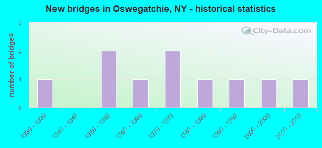
- New bridges - historical statistics
- 11930-1939
- 21950-1959
- 11960-1969
- 21970-1979
- 11980-1989
- 11990-1999
- 12000-2009
- 12010-2019


- Bridge Condition - Deck
- 16.7%Very good
- 33.3%Good
- 33.3%Satisfactory
- 16.7%Fair

- Bridge Condition - Superstructure
- 28.6%Excellent
- 42.9%Good
- 14.3%Satisfactory
- 14.3%Poor

- Bridge Condition - Substructure
- 14.3%Excellent
- 28.6%Very good
- 14.3%Good
- 42.9%Fair

- Bridge Condition - Channel
- 11.1%Excellent
- 44.4%Very good
- 22.2%Good
- 11.1%Satisfactory
- 11.1%Poor

- Bridge Condition - Culverts
- 33.3%Excellent
- 33.3%Satisfactory
- 33.3%Poor
Find on map >> Show street view
Structure Number: 102382, Location: JCT SH37 & OSWEGATCHIE RV (Lat: 44.683750, Lng: -75.489031), Route carried "on" structure: State highway 37, Year Built: 1958, Status: Open, Structure Length: 16.58m (54.40ft), Average Daily Traffic: 9,601 (year 2018), Truck Traffic: 10%, Average Future Daily Traffic: 9,646 (year 2040), Design Load: H 20, Features Intersected: OSWEGATCHIE RIVER, TRAIL
Minimum Vertical Clearance: 30+ m (98+ ft), Kilometerpoint: 44.875, Lanes on structure: 2, Base Highway Network: Yes, Owner: State Highway Agency, Approaching Roadway Width: 13.4m (44.0ft), Material/Design: Steel, Design/Construction: Stringer/Multi-beam, Number Of Spans In Main Unit: 5, Length of Maximum Span: 32.9m (107.9ft), Curb or Sidewalk Widths: Left: 0.5m (1.6ft), Right: 0.5m (1.6ft), Curb-To-Curb Width: 9.1m (29.9ft), Out-to-Out Width: 10.7m (35.1ft)
Condition: Deck: Satisfactory, Superstructure: Satisfactory, Substructure: Fair, Channel: Very good, Operating Rating: 48.1 metric tons, Method Used To Determine Operating Rating: Load Factor (LF), Inventory Rating: 26.3 metric tons, Method Used To Determine Inventory Rating: Load Factor (LF), Structural Evaluation: Somewhat better than minimum adequacy, Deck Geometry: Meets minimum limits, Waterway Adequacy: Superior to present desirable criteria, Approach Roadway Alignment: Equal to present desirable criteria, Length Of Structure Improvement: 16.58m (54.40ft), Designated Inspection Frequency: Every 24 months, Underwater Inspection Frequency: Every 60 months, Inspection Date: October 2021, Underwater Inspection Date: May 2018, Bridge Improvement Cost: $3,116,000, Roadway Improvement Cost: $1,825,000, Total Project Cost: $4,941,000 ( Estimate for 2021), Deck Structure Type: Concrete Cast-file-Place, Wearing Surface/Protective System: Wearing Surface: Bituminous, Membrane: Other
Find on map >> Show street view
Structure Number: 102383, Location: JCT RTES 37 & 812 (970E) (Lat: 44.686058, Lng: -75.483417), Route carried "on" structure: State highway 37, Year Built: 1958, Status: Open, Structure Length: 4.48m (14.70ft), Average Daily Traffic: 9,601 (year 2018), Truck Traffic: 10%, Average Future Daily Traffic: 9,646 (year 2040), Design Load: H 20, Features Intersected: RTE 970E
Minimum Vertical Clearance: 30+ m (98+ ft), Kilometerpoint: 45.342, Lanes on structure: 2, Lanes under structure: 2, Base Highway Network: Yes, Owner: State Highway Agency, Approaching Roadway Width: 13.4m (44.0ft), Material/Design: Steel, Design/Construction: Stringer/Multi-beam, Number Of Spans In Main Unit: 3, Length of Maximum Span: 19.5m (64.0ft), Curb or Sidewalk Widths: Left: 0.5m (1.6ft), Right: 0.5m (1.6ft), Curb-To-Curb Width: 9.1m (29.9ft), Out-to-Out Width: 10.8m (35.4ft)
Condition: Deck: Satisfactory, Superstructure: Good, Substructure: Fair, Operating Rating: 71.7 metric tons, Method Used To Determine Operating Rating: Load Factor (LF), Inventory Rating: 42.6 metric tons, Method Used To Determine Inventory Rating: Load Factor (LF), Structural Evaluation: Somewhat better than minimum adequacy, Deck Geometry: High priority of corrective action, Underclear: Somewhat better than minimum adequacy, Approach Roadway Alignment: Equal to present desirable criteria, Length Of Structure Improvement: 4.48m (14.70ft), Designated Inspection Frequency: Every 24 months, Inspection Date: November 2020, Bridge Improvement Cost: $919,000, Roadway Improvement Cost: $538,000, Total Project Cost: $1,457,000 ( Estimate for 2021), Deck Structure Type: Concrete Cast-file-Place, Wearing Surface/Protective System: Wearing Surface: Bituminous, Membrane: Other
Find on map >> Show street view
Structure Number: 102929, Location: 2.6 MI SE JCT RTS 68 + 37 (Lat: 44.672083, Lng: -75.425925), Route carried "on" structure: State highway 68, Year Built: 2011, Status: Open, Structure Length: 0.70m (2.30ft), Average Daily Traffic: 4,345 (year 2020), Truck Traffic: 10%, Average Future Daily Traffic: 4,371 (year 2040), Design Load: HS 25 or greater, Features Intersected: TIBITTS CREEK
Minimum Vertical Clearance: 30+ m (98+ ft), Kilometerpoint: 9.380, Lanes on structure: 2, Base Highway Network: Yes, Owner: State Highway Agency, Approaching Roadway Width: 16.8m (55.1ft), Skew: 3 degrees, Material/Design: Concrete, Design/Construction: Culvert, Number Of Spans In Main Unit: 1, Length of Maximum Span: 6.7m (22.0ft), Curb-To-Curb Width: 16.8m (55.1ft), Out-to-Out Width: 24.2m (79.4ft)
Condition: Channel: Very good, Culverts: Excellent, Operating Rating: 65.3 metric tons, Method Used To Determine Operating Rating: Load Factor (LF), Inventory Rating: 39.0 metric tons, Method Used To Determine Inventory Rating: Load Factor (LF), Structural Evaluation: Superior to present desirable criteria, Deck Geometry: Superior to present desirable criteria, Waterway Adequacy: Equal to present minimum criteria, Approach Roadway Alignment: Equal to present desirable criteria, Length Of Structure Improvement: 0.70m (2.30ft), Designated Inspection Frequency: Every 24 months, Inspection Date: October 2021, Bridge Improvement Cost: $340,000, Roadway Improvement Cost: $199,000, Total Project Cost: $538,000 ( Estimate for 2021)
Find on map >> Show street view
Structure Number: 106927, Location: 2 MI SE JCT SH812 & SH184 (Lat: 44.590442, Lng: -75.371939), Route carried "on" structure: State highway 812, Year Built: 2004, Status: Open, Structure Length: 0.94m (3.08ft), Average Daily Traffic: 2,251 (year 2018), Truck Traffic: 11%, Average Future Daily Traffic: 2,272 (year 2040), Design Load: HS 25 or greater, Features Intersected: BEAVER CREEK
Minimum Vertical Clearance: 30+ m (98+ ft), Kilometerpoint: 59.790, Lanes on structure: 2, Base Highway Network: Yes, Owner: State Highway Agency, Approaching Roadway Width: 11.9m (39.0ft), Material/Design: Concrete, Design/Construction: Frame, Number Of Spans In Main Unit: 1, Length of Maximum Span: 9.1m (29.9ft), Curb-To-Curb Width: 12.0m (39.4ft), Out-to-Out Width: 12.6m (41.3ft)
Condition: Superstructure: Excellent, Substructure: Excellent, Channel: Very good, Operating Rating: 82.1 metric tons, Method Used To Determine Operating Rating: Load Factor (LF), Inventory Rating: 49.2 metric tons, Method Used To Determine Inventory Rating: Load Factor (LF), Structural Evaluation: Superior to present desirable criteria, Deck Geometry: Somewhat better than minimum adequacy, Waterway Adequacy: Equal to present desirable criteria, Approach Roadway Alignment: Equal to present desirable criteria, Length Of Structure Improvement: 0.94m (3.08ft), Designated Inspection Frequency: Every 24 months, Inspection Date: October 2020, Bridge Improvement Cost: $671,000, Roadway Improvement Cost: $393,000, Total Project Cost: $1,065,000 ( Estimate for 2021)
Find on map >> Show street view
Structure Number: 222149, Location: 4 MILES S OF OGDENSBURG (Lat: 44.632800, Lng: -75.501578), Route carried "on" structure: Other road , Year Built: 1970, Status: Open, Structure Length: 0.61m (2.00ft), Average Daily Traffic: 245 (year 2018), Truck Traffic: 2%, Average Future Daily Traffic: 343 (year 2038), Features Intersected: CRUMMIE CREEK, Facility Carried by Structure: LOST VILLAGE ROAD
Minimum Vertical Clearance: 30+ m (98+ ft), Kilometerpoint: 6.291, Lanes on structure: 2, Owner: Town or Township Highway Agency, Approaching Roadway Width: 5.5m (18.0ft), Material/Design: Steel, Design/Construction: Culvert, Number Of Spans In Main Unit: 3, Length of Maximum Span: 1.8m (5.9ft)
Condition: Channel: Poor, Culverts: Poor, Operating Rating: 73.3 metric tons, Method Used To Determine Operating Rating: Field evaluation and documented engineering judgment, Inventory Rating: 19.6 metric tons, Method Used To Determine Inventory Rating: Field evaluation and documented engineering judgment, Structural Evaluation: Meets minimum limits, Waterway Adequacy: Meets minimum limits, Approach Roadway Alignment: Meets minimum limits, Length Of Structure Improvement: 0.60m (1.97ft), Designated Inspection Frequency: Every 12 months, Inspection Date: October 2021, Bridge Improvement Cost: $67,000, Roadway Improvement Cost: $39,000, Total Project Cost: $106,000 ( Estimate for 2021)
Find on map >> Show street view
Structure Number: 222152, Location: 1.5 MI E OF OGDENSBURG (Lat: 44.697114, Lng: -75.445458), Route carried "on" structure: County highway , Year Built: 1970, Status: Open, Structure Length: 0.76m (2.49ft), Average Daily Traffic: 914 (year 2018), Truck Traffic: 5%, Average Future Daily Traffic: 1,280 (year 2038), Features Intersected: TIBBITS CREEK, Facility Carried by Structure: COUNTY ROAD 28A
Minimum Vertical Clearance: 30+ m (98+ ft), Kilometerpoint: 1.448, Lanes on structure: 2, Owner: County Highway Agency, Approaching Roadway Width: 5.5m (18.0ft), Material/Design: Steel, Design/Construction: Culvert, Number Of Spans In Main Unit: 2, Length of Maximum Span: 3.6m (11.8ft)
Condition: Channel: Satisfactory, Culverts: Satisfactory, Operating Rating: 75.1 metric tons, Method Used To Determine Operating Rating: Field evaluation and documented engineering judgment, Inventory Rating: 32.7 metric tons, Method Used To Determine Inventory Rating: Field evaluation and documented engineering judgment, Structural Evaluation: Equal to present minimum criteria, Waterway Adequacy: Somewhat better than minimum adequacy, Approach Roadway Alignment: Meets minimum limits, Length Of Structure Improvement: 0.76m (2.49ft), Designated Inspection Frequency: Every 24 months, Inspection Date: August 2021, Bridge Improvement Cost: $84,000, Roadway Improvement Cost: $49,000, Total Project Cost: $133,000 ( Estimate for 2021)
Find on map >> Show street view
Structure Number: 334144, Location: 1.0 MI S OF OGDENSBURG (Lat: 44.669422, Lng: -75.491617), Route carried "on" structure: County highway , Year Built: 1997, Status: Open, Structure Length: 1.13m (3.71ft), Average Daily Traffic: 2,039 (year 2018), Truck Traffic: 3%, Average Future Daily Traffic: 2,855 (year 2038), Features Intersected: SUCKER CREEK, Facility Carried by Structure: JEFF HAMM OGDB R
Minimum Vertical Clearance: 30+ m (98+ ft), Kilometerpoint: 30.684, Lanes on structure: 2, Owner: County Highway Agency, Approaching Roadway Width: 9.8m (32.2ft), Material/Design: Concrete, Design/Construction: Frame, Number Of Spans In Main Unit: 1, Length of Maximum Span: 10.9m (35.8ft), Curb-To-Curb Width: 9.8m (32.2ft), Out-to-Out Width: 10.6m (34.8ft)
Condition: Deck: Good, Superstructure: Good, Substructure: Very good, Channel: Very good, Operating Rating: 76.2 metric tons, Method Used To Determine Operating Rating: Load Factor (LF), Inventory Rating: 45.4 metric tons, Method Used To Determine Inventory Rating: Load Factor (LF), Structural Evaluation: Better than present minimum criteria, Deck Geometry: Meets minimum limits, Waterway Adequacy: Equal to present minimum criteria, Approach Roadway Alignment: Equal to present desirable criteria, Length Of Structure Improvement: 1.12m (3.67ft), Designated Inspection Frequency: Every 24 months, Inspection Date: September 2021, Bridge Improvement Cost: $472,000, Roadway Improvement Cost: $277,000, Total Project Cost: $749,000 ( Estimate for 2021)
Find on map >> Show street view
Structure Number: 334145, Location: 4.5 MILES NW OF HUVELTON (Lat: 44.631672, Lng: -75.476122), Route carried "on" structure: County highway , Year Built: 1960, Year Reconstructed: 2014, Status: Open, Structure Length: 8.23m (27.00ft), Average Daily Traffic: 969 (year 2018), Truck Traffic: 11%, Average Future Daily Traffic: 1,357 (year 2038), Design Load: HL 93, Features Intersected: OSWEGATCHIE RIVER, Facility Carried by Structure: EEL WEIR ROAD
Minimum Vertical Clearance: 30+ m (98+ ft), Kilometerpoint: 3.347, Lanes on structure: 2, Owner: County Highway Agency, Approaching Roadway Width: 8.5m (27.9ft), Material/Design: Steel, Design/Construction: Stringer/Multi-beam, Number Of Spans In Main Unit: 4, Length of Maximum Span: 20.1m (65.9ft), Curb-To-Curb Width: 8.5m (27.9ft), Out-to-Out Width: 9.5m (31.2ft)
Condition: Deck: Very good, Superstructure: Excellent, Substructure: Very good, Channel: Excellent, Inventory Rating: 64.4 metric tons, Method Used To Determine Inventory Rating: Load Factor (LF), Structural Evaluation: Equal to present desirable criteria, Deck Geometry: Somewhat better than minimum adequacy, Waterway Adequacy: Equal to present desirable criteria, Approach Roadway Alignment: Equal to present minimum criteria, Length Of Structure Improvement: 8.22m (26.97ft), Designated Inspection Frequency: Every 24 months, Inspection Date: November 2020, Bridge Improvement Cost: $1,498,000, Roadway Improvement Cost: $877,000, Total Project Cost: $2,375,000 ( Estimate for 2021), Deck Structure Type: Concrete Cast-file-Place, Wearing Surface/Protective System: Wearing Surface: Integral Concrete, Deck Protection: Epoxy Coated Reinforcing
Find on map >> Show street view
Structure Number: 334146, Location: .75 MILE E OF HEUVELTON (Lat: 44.621378, Lng: -75.392389), Route carried "on" structure: County highway , Year Built: 1933, Status: Open, Structure Length: 1.34m (4.40ft), Average Daily Traffic: 1,034 (year 2019), Truck Traffic: 5%, Average Future Daily Traffic: 1,448 (year 2039), Features Intersected: LISBON CREEK, Facility Carried by Structure: COUNTY ROAD 15
Minimum Vertical Clearance: 30+ m (98+ ft), Kilometerpoint: 6.339, Lanes on structure: 2, Owner: County Highway Agency, Approaching Roadway Width: 6.1m (20.0ft), Material/Design: Steel, Design/Construction: Stringer/Multi-beam, Number Of Spans In Main Unit: 1, Length of Maximum Span: 12.8m (42.0ft), Curb-To-Curb Width: 9.8m (32.2ft), Out-to-Out Width: 10.3m (33.8ft)
Condition: Deck: Good, Superstructure: Good, Substructure: Good, Channel: Good, Operating Rating: 25.3 metric tons, Method Used To Determine Operating Rating: Load and Resistance Factor Rating (LRFR) rating reported by rating factor(RF) method using HL-93 loadings, Inventory Rating: 19.4 metric tons, Method Used To Determine Inventory Rating: Load and Resistance Factor Rating (LRFR) rating reported by rating factor(RF) method using HL-93 loadings, Structural Evaluation: Somewhat better than minimum adequacy, Deck Geometry: Somewhat better than minimum adequacy, Waterway Adequacy: Meets minimum limits, Approach Roadway Alignment: Somewhat better than minimum adequacy, Length Of Structure Improvement: 1.34m (4.40ft), Designated Inspection Frequency: Every 24 months, Inspection Date: September 2021, Bridge Improvement Cost: $571,000, Roadway Improvement Cost: $334,000, Total Project Cost: $905,000 ( Estimate for 2021), Deck Structure Type: Concrete Cast-file-Place, Wearing Surface/Protective System: Wearing Surface: Bituminous, Membrane: Other
Find on map >> Show street view
Structure Number: 336667, Location: 1.4 MI NE OF HEUVELTON (Lat: 44.634619, Lng: -75.373969), Route carried "on" structure: Other road , Year Built: 1980, Status: Posted for load, Structure Length: 0.94m (3.08ft), Average Daily Traffic: 158 (year 2020), Truck Traffic: 3%, Average Future Daily Traffic: 221 (year 2040), Design Load: H 20, Features Intersected: LISBON CREEK, Facility Carried by Structure: TOWN LINE ROAD
Minimum Vertical Clearance: 30+ m (98+ ft), Kilometerpoint: 0.499, Lanes on structure: 2, Owner: County Highway Agency, Approaching Roadway Width: 4.9m (16.1ft), Skew: 1 degrees, Material/Design: Steel, Design/Construction: Girder and Floorbeam System, Number Of Spans In Main Unit: 1, Length of Maximum Span: 8.8m (28.9ft), Curb-To-Curb Width: 7.5m (24.6ft), Out-to-Out Width: 7.7m (25.3ft)
Condition: Deck: Fair, Superstructure: Poor, Substructure: Fair, Channel: Good, Operating Rating: 43.5 metric tons, Method Used To Determine Operating Rating: Load Factor (LF), Inventory Rating: 25.4 metric tons, Method Used To Determine Inventory Rating: Load Factor (LF), Structural Evaluation: Meets minimum limits, Deck Geometry: Somewhat better than minimum adequacy, Waterway Adequacy: Meets minimum limits, Approach Roadway Alignment: Equal to present desirable criteria, Bridge Posting: Required (Relationship of Operating Rating to Maximum Legal Load: > 39.9% below), Length Of Structure Improvement: 0.94m (3.08ft), Designated Inspection Frequency: Every 12 months, Critical Feature Inspection Frequency: Every 12 months, Inspection Date: September 2021, Critical Feature Inspection Date: September 2021, Bridge Improvement Cost: $250,000, Roadway Improvement Cost: $147,000, Total Project Cost: $397,000 ( Estimate for 2021), Deck Structure Type: Wood or Timber, Wearing Surface/Protective System: Wearing Surface: Bituminous