Bridge Statistics for Palm Beach, Florida (FL)
Condition, Traffic, Stress, Structural Evaluation, Project Costs
- National Bridge Inventory (NBI) Statistics
- 12Number of bridges
- 328ft / 100mTotal length
- 342,795Total average daily traffic
- 23,917Total average daily truck traffic
- National Bridge Inventory (NBI) Registered Bridges for Palm Beach
- No street view available for this location
- New bridges - historical statistics
- 11930-1939
- 11940-1949
- 11950-1959
- 41970-1979
- 22000-2009
- 22010-2019
- 12020-2022
- Reconstructed bridges - Historical Statistics
- 11980-1989
- 11990-1999
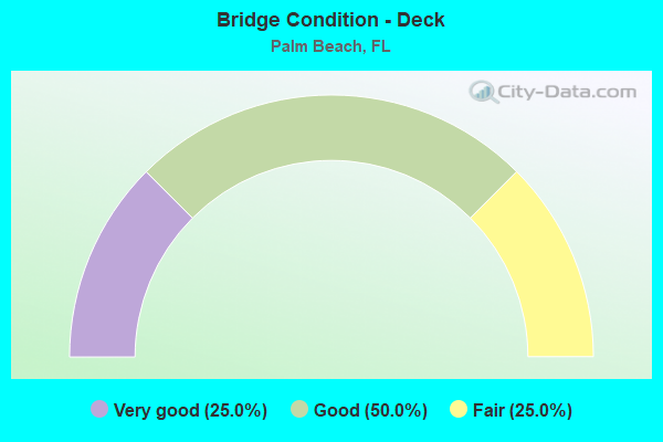
- Bridge Condition - Deck
- 25.0%Very good
- 50.0%Good
- 25.0%Fair
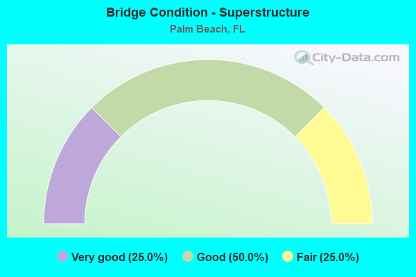
- Bridge Condition - Superstructure
- 25.0%Very good
- 50.0%Good
- 25.0%Fair
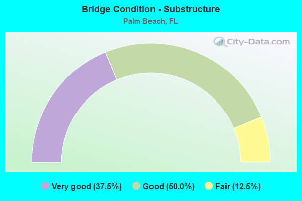
- Bridge Condition - Substructure
- 37.5%Very good
- 50.0%Good
- 12.5%Fair
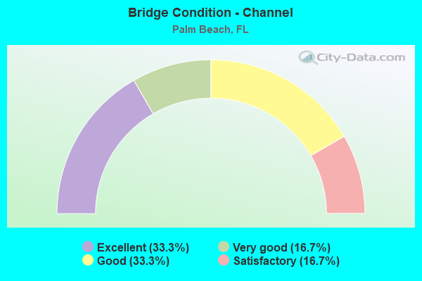
- Bridge Condition - Channel
- 33.3%Excellent
- 16.7%Very good
- 33.3%Good
- 16.7%Satisfactory
Find on map >> Show street view
Structure Number: 930547, Location: 0.2 mi E of SR5 on SRA1A (Lat: 26.718217, Lng: -80.043436), Route carried "on" structure: State highway A1A, Year Built: 2016, Status: Open, Structure Length: 51.63m (169.39ft), Average Daily Traffic: 15,119 (year 2021), Truck Traffic: 5%, Average Future Daily Traffic: 26,231 (year 2042), Design Load: HL 93, Features Intersected: Lake Worth Lagoon
Minimum Vertical Clearance: 5.18m (16.99ft), Kilometerpoint: 45.580, Lanes on structure: 4, Base Highway Network: Yes, Owner: State Highway Agency, Approaching Roadway Width: 24.2m (79.4ft), Skew: 10 degrees, Navigation Control: Yes ( Vertical Clearance: 7.2m (23.6ft), Horizontal Clearance: 38.1m (125.0ft)), Material/Design: Steel, Design/Construction: Movable - Bascule, Number Of Spans In Main Unit: 1, Number Of Approach Spans: 10, Length of Maximum Span: 65.2m (213.9ft), Curb or Sidewalk Widths: Left: 2.7m (8.9ft), Right: 2.7m (8.9ft), Curb-To-Curb Width: 24.2m (79.4ft), Out-to-Out Width: 30.6m (100.4ft)
Condition: Deck: Very good, Superstructure: Good, Substructure: Very good, Channel: Excellent, Operating Rating: 57.8 metric tons, Method Used To Determine Operating Rating: Load and Resistance Factor (LRFR), Inventory Rating: 44.1 metric tons, Method Used To Determine Inventory Rating: Load and Resistance Factor (LRFR), Structural Evaluation: Better than present minimum criteria, Deck Geometry: Superior to present desirable criteria, Waterway Adequacy: Superior to present desirable criteria, Approach Roadway Alignment: Equal to present desirable criteria, Designated Inspection Frequency: Every 24 months, Critical Feature Inspection Frequency: Every 24 months, Underwater Inspection Frequency: Every 24 months, Other Special Inspection Frequency: Every 12 months, Inspection Date: October 2021, Critical Feature Inspection Date: October 2021, Underwater Inspection Date: October 2021, Other Special Inspection Date: October 2021, Deck Structure Type: Concrete Cast-file-Place
Find on map >> Show street view
Structure Number: 930558, Location: 1.7 Miles East of I-95 (Lat: 26.675833, Lng: -8.040556), Route carried "on" structure: State highway 98, Year Built: 2020, Status: Open, Structure Length: 10.97m (35.99ft), Average Daily Traffic: 16,900 (year 2017), Average Future Daily Traffic: 18,700 (year 2037), Design Load: HL 93, Features Intersected: Lake Worth Lagoon, Facility Carried by Structure: SR-80 (Southern)
Minimum Vertical Clearance: 30.45m (99.90ft), Kilometerpoint: 34.969, Lanes on structure: 2, Owner: State Highway Agency, Approaching Roadway Width: 6.7m (22.0ft), Material/Design: Concrete, Design/Construction: Slab, Number Of Spans In Main Unit: 7, Length of Maximum Span: 16.5m (54.1ft), Curb or Sidewalk Widths: Left: 0.3m (1.0ft), Right: 1.8m (5.9ft), Curb-To-Curb Width: 6.7m (22.0ft), Out-to-Out Width: 10.4m (34.1ft)
Condition: Deck: Very good, Superstructure: Very good, Substructure: Very good, Channel: Excellent, Operating Rating: 53.9 metric tons, Method Used To Determine Operating Rating: Load and Resistance Factor (LRFR), Inventory Rating: 41.5 metric tons, Method Used To Determine Inventory Rating: Load and Resistance Factor (LRFR), Structural Evaluation: Equal to present desirable criteria, Deck Geometry: High priority of replacement, Waterway Adequacy: Superior to present desirable criteria, Approach Roadway Alignment: Better than present minimum criteria, Designated Inspection Frequency: Every 24 months, Underwater Inspection Frequency: Every 24 months, Inspection Date: November 2020, Underwater Inspection Date: November 2020, Deck Structure Type: Concrete Cast-file-Place
Find on map >> Show street view
Structure Number: 93094, Location: 0.1MI W of US-98 / SR-441 (Lat: 26.685475, Lng: -80.389047), Route carried "on" structure: County highway 880, Year Built: 1937, Status: Posted for load, Structure Length: 6.70m (21.98ft), Average Daily Traffic: 14,400 (year 2021), Truck Traffic: 17%, Average Future Daily Traffic: 17,280 (year 2042), Design Load: H 15, Features Intersected: C-51 CANAL
Minimum Vertical Clearance: 5.69m (18.67ft), Kilometerpoint: 0.103, Lanes on structure: 2, Base Highway Network: Yes, Owner: County Highway Agency, Approaching Roadway Width: 7.3m (24.0ft), Material/Design: Steel continuous, Design/Construction: Truss - Thru, Number Of Spans In Main Unit: 2, Number Of Approach Spans: 1, Length of Maximum Span: 56.1m (184.1ft), Curb or Sidewalk Widths: Left: 0.2m (0.7ft), Right: 0.2m (0.7ft), Curb-To-Curb Width: 7.3m (24.0ft), Out-to-Out Width: 8.1m (26.6ft)
Condition: Deck: Fair, Superstructure: Fair, Substructure: Good, Channel: Good, Operating Rating: 50.6 metric tons, Method Used To Determine Operating Rating: Load Factor (LF), Inventory Rating: 30.3 metric tons, Method Used To Determine Inventory Rating: Load Factor (LF), Structural Evaluation: Somewhat better than minimum adequacy, Deck Geometry: High priority of replacement, Waterway Adequacy: Equal to present desirable criteria, Approach Roadway Alignment: Equal to present desirable criteria, Bridge Posting: Required (Relationship of Operating Rating to Maximum Legal Load: 30.0 - 39.9% below), Designated Inspection Frequency: Every 24 months, Critical Feature Inspection Frequency: Every 24 months, Underwater Inspection Frequency: Every 24 months, Other Special Inspection Frequency: Every 12 months, Inspection Date: August 2021, Critical Feature Inspection Date: August 2021, Underwater Inspection Date: August 2021, Other Special Inspection Date: August 2021, Deck Structure Type: Closed Grating
Find on map >> Show street view
Structure Number: 931006, Location: 5.1 MI SOUTH OF SR-804 (Lat: 26.453747, Lng: -80.174539), Route carried "on" structure: State highway 91, Year Built: 2008, Status: Open, Structure Length: 5.85m (19.19ft), Average Daily Traffic: 90,100 (year 2021), Truck Traffic: 13%, Average Future Daily Traffic: 156,324 (year 2042), Design Load: HS 20, Features Intersected: SR-806 Atlantic Ave
Minimum Vertical Clearance: 30+ m (98+ ft), Kilometerpoint: 13.900, Lanes on structure: 7, Lanes under structure: 6, Base Highway Network: Yes, Toll: On toll road, Owner: State Toll Authority, Approaching Roadway Width: 21.3m (69.9ft), Skew: 38 degrees, Material/Design: Prestressed concrete, Design/Construction: Stringer/Multi-beam, Number Of Spans In Main Unit: 2, Length of Maximum Span: 30.2m (99.1ft), Curb-To-Curb Width: 47.5m (155.8ft), Out-to-Out Width: 48.5m (159.1ft)
Condition: Deck: Good, Superstructure: Very good, Substructure: Very good, Operating Rating: 71.2 metric tons, Method Used To Determine Operating Rating: Load Factor (LF), Inventory Rating: 44.4 metric tons, Method Used To Determine Inventory Rating: Load Factor (LF), Structural Evaluation: Equal to present desirable criteria, Deck Geometry: Superior to present desirable criteria, Underclear: Better than present minimum criteria, Approach Roadway Alignment: Equal to present desirable criteria, Designated Inspection Frequency: Every 24 months, Inspection Date: October 2021, Deck Structure Type: Concrete Cast-file-Place
Find on map >> Show street view
Structure Number: 934275, Location: 0.5MI EAST OF I-95 (Lat: 26.705722, Lng: -80.065917), Route carried "on" structure: County highway , Year Built: 1973, Status: Open, Structure Length: 7.74m (25.39ft), Average Daily Traffic: 24,000 (year 2020), Truck Traffic: 3%, Average Future Daily Traffic: 41,640 (year 2042), Features Intersected: OKEECHOBEE BLVD, Facility Carried by Structure: AUSTRALIAN AVE SB
Minimum Vertical Clearance: 30+ m (98+ ft), Kilometerpoint: 3.650, Lanes on structure: 3, Lanes under structure: 8, Base Highway Network: Yes, Owner: County Highway Agency, Approaching Roadway Width: 11.0m (36.1ft), Skew: 3 degrees, Material/Design: Prestressed concrete, Design/Construction: Stringer/Multi-beam, Number Of Spans In Main Unit: 4, Length of Maximum Span: 25.9m (85.0ft), Curb or Sidewalk Widths: Left: 1.6m (5.2ft), Right: 0.5m (1.6ft), Curb-To-Curb Width: 11.0m (36.1ft), Out-to-Out Width: 13.7m (44.9ft)
Condition: Deck: Good, Superstructure: Good, Substructure: Good, Operating Rating: 62.7 metric tons, Method Used To Determine Operating Rating: Load Factor (LF), Inventory Rating: 37.6 metric tons, Method Used To Determine Inventory Rating: Load Factor (LF), Structural Evaluation: Better than present minimum criteria, Deck Geometry: High priority of replacement, Underclear: Better than present minimum criteria, Approach Roadway Alignment: Better than present minimum criteria, Designated Inspection Frequency: Every 24 months, Inspection Date: March 2020, Deck Structure Type: Concrete Precast Panels
Find on map >> Show street view
Structure Number: 934276, Location: 0.5MI EAST OF I-95 (Lat: 26.705739, Lng: -80.065703), Route carried "on" structure: County highway , Year Built: 1973, Status: Open, Structure Length: 7.74m (25.39ft), Average Daily Traffic: 24,000 (year 2020), Truck Traffic: 3%, Average Future Daily Traffic: 41,640 (year 2042), Design Load: HS 20, Features Intersected: OKEECHOBEE BLVD, Facility Carried by Structure: AUSTRALIAN AVE NB
Minimum Vertical Clearance: 30+ m (98+ ft), Kilometerpoint: 3.650, Lanes on structure: 3, Lanes under structure: 8, Base Highway Network: Yes, Owner: County Highway Agency, Approaching Roadway Width: 12.1m (39.7ft), Skew: 3 degrees, Material/Design: Prestressed concrete, Design/Construction: Stringer/Multi-beam, Number Of Spans In Main Unit: 4, Length of Maximum Span: 26.0m (85.3ft), Curb or Sidewalk Widths: Left: 0.5m (1.6ft), Right: 0.5m (1.6ft), Curb-To-Curb Width: 12.1m (39.7ft), Out-to-Out Width: 13.7m (44.9ft)
Condition: Deck: Good, Superstructure: Good, Substructure: Good, Operating Rating: 62.7 metric tons, Method Used To Determine Operating Rating: Load Factor (LF), Inventory Rating: 37.6 metric tons, Method Used To Determine Inventory Rating: Load Factor (LF), Structural Evaluation: Better than present minimum criteria, Deck Geometry: Meets minimum limits, Underclear: Better than present minimum criteria, Approach Roadway Alignment: Better than present minimum criteria, Designated Inspection Frequency: Every 24 months, Inspection Date: March 2020, Deck Structure Type: Concrete Precast Panels
Find on map >> Show street view
Structure Number: 934373, Location: In John Prince Park (Lat: 26.599083, Lng: -80.080611), Route carried "on" structure: County highway , Year Built: 2015, Status: Open, Structure Length: 0.69m (2.26ft), Average Daily Traffic: 150 (year 2021), Truck Traffic: 1%, Average Future Daily Traffic: 180 (year 2042), Design Load: HL 93, Features Intersected: Lake Osborne, Facility Carried by Structure: Camp Site Road
Minimum Vertical Clearance: 30+ m (98+ ft), Kilometerpoint: 0.000, Lanes on structure: 2, Owner: City or Municipal Highway Agency, Approaching Roadway Width: 8.5m (27.9ft), Material/Design: Concrete, Design/Construction: Culvert, Number Of Spans In Main Unit: 1, Length of Maximum Span: 6.9m (22.6ft), Curb or Sidewalk Widths: Left: 1.7m (5.6ft), Right: 0.0m, Curb-To-Curb Width: 8.5m (27.9ft), Out-to-Out Width: 11.0m (36.1ft)
Condition: Channel: Very good, Culverts: Very good, Operating Rating: 57.6 metric tons, Method Used To Determine Operating Rating: Load and Resistance Factor (LRFR), Inventory Rating: 44.5 metric tons, Method Used To Determine Inventory Rating: Load and Resistance Factor (LRFR), Structural Evaluation: Equal to present desirable criteria, Deck Geometry: Equal to present minimum criteria, Waterway Adequacy: Equal to present desirable criteria, Approach Roadway Alignment: Better than present minimum criteria, Designated Inspection Frequency: Every 24 months, Underwater Inspection Frequency: Every 24 months, Inspection Date: April 2021, Underwater Inspection Date: April 2021, Deck Structure Type: Concrete Cast-file-Place, Wearing Surface/Protective System: Wearing Surface: Bituminous
Find on map >> Show street view
Structure Number: 936801, Location: 0.1MI WEST OF A1A (Lat: 26.639136, Lng: -80.040675), Route carried "on" structure: City street , Year Built: 1952, Year Reconstructed: 1997, Status: Open, Structure Length: 0.98m (3.22ft), Average Daily Traffic: 324 (year 2022), Truck Traffic: 4%, Average Future Daily Traffic: 521 (year 2042), Features Intersected: LAKE WORTH TRIBUTARY, Facility Carried by Structure: IBIS WAY
Minimum Vertical Clearance: 30+ m (98+ ft), Kilometerpoint: 0.000, Lanes on structure: 2, Owner: Town or Township Highway Agency, Approaching Roadway Width: 6.1m (20.0ft), Material/Design: Concrete, Design/Construction: Tee Beam, Number Of Spans In Main Unit: 1, Length of Maximum Span: 9.8m (32.2ft), Curb or Sidewalk Widths: Left: 1.1m (3.6ft), Right: 1.1m (3.6ft), Curb-To-Curb Width: 6.7m (22.0ft), Out-to-Out Width: 9.6m (31.5ft)
Condition: Deck: Good, Superstructure: Good, Substructure: Good, Channel: Good, Operating Rating: 44.1 metric tons, Method Used To Determine Operating Rating: Load Factor (LF), Inventory Rating: 26.5 metric tons, Method Used To Determine Inventory Rating: Load Factor (LF), Structural Evaluation: Equal to present minimum criteria, Deck Geometry: Meets minimum limits, Waterway Adequacy: Better than present minimum criteria, Approach Roadway Alignment: Equal to present desirable criteria, Designated Inspection Frequency: Every 24 months, Inspection Date: January 2022, Deck Structure Type: Concrete Cast-file-Place
Find on map >> Show street view
Structure Number: 936802, Location: 0.4MI W of S. COUNTY ROAD (Lat: 26.695244, Lng: -80.042603), Route carried "on" structure: City street , Year Built: 1946, Year Reconstructed: 1988, Status: Posted for load-capacity, Structure Length: 8.05m (26.41ft), Average Daily Traffic: 802 (year 2022), Truck Traffic: 1%, Average Future Daily Traffic: 1,301 (year 2042), Design Load: HS 20, Features Intersected: LAKE WORTH, Facility Carried by Structure: ISLAND ROAD
Minimum Vertical Clearance: 30+ m (98+ ft), Kilometerpoint: 0.000, Lanes on structure: 2, Owner: Town or Township Highway Agency, Approaching Roadway Width: 5.8m (19.0ft), Material/Design: Concrete, Design/Construction: Tee Beam, Number Of Spans In Main Unit: 7, Length of Maximum Span: 11.6m (38.1ft), Curb-To-Curb Width: 6.1m (20.0ft), Out-to-Out Width: 6.1m (20.0ft)
Condition: Deck: Fair, Superstructure: Fair, Substructure: Fair, Channel: Satisfactory, Operating Rating: 79.8 metric tons, Method Used To Determine Operating Rating: Load Factor (LF), Inventory Rating: 48.1 metric tons, Method Used To Determine Inventory Rating: Load Factor (LF), Structural Evaluation: Somewhat better than minimum adequacy, Deck Geometry: High priority of corrective action, Waterway Adequacy: Equal to present desirable criteria, Approach Roadway Alignment: Better than present minimum criteria, Designated Inspection Frequency: Every 24 months, Underwater Inspection Frequency: Every 24 months, Inspection Date: January 2022, Underwater Inspection Date: January 2022, Deck Structure Type: Concrete Cast-file-Place
Find on map >> Show street view
Structure Number: 931006, Location: 5.1 MI SOUTH OF SR-804 (Lat: 26.453747, Lng: -80.174539), Route carried "under" structure: State highway 806, Year Built: 2008, Structure Length: 0. m, Average Daily Traffic: 31,000 (year 2021), Truck Traffic: 8%, Features Intersected: SR-806 Atlantic Ave, Facility Carried by Structure: SR-91 TPK NS 81.77
Minimum Vertical Clearance: 5.27m (17.29ft), Kilometerpoint: 2.968, Lanes on structure: 7, Lanes under structure: 6, Material/Design: Prestressed concrete, Design/Construction: Stringer/Multi-beam, Length of Maximum Span: 30.2m (99.1ft)
Find on map >> Show street view
Structure Number: 934275, Location: 0.5MI EAST OF I-95 (Lat: 26.705722, Lng: -80.065917), Route carried "under" structure: State highway 704, Year Built: 1973, Structure Length: 0. m, Average Daily Traffic: 62,500 (year 2020), Truck Traffic: 2%, Features Intersected: OKEECHOBEE BLVD, Facility Carried by Structure: AUSTRALIAN AVE SB
Minimum Vertical Clearance: 5.00m (16.40ft), Kilometerpoint: 13.425, Lanes on structure: 3, Lanes under structure: 8, Material/Design: Prestressed concrete, Design/Construction: Stringer/Multi-beam, Length of Maximum Span: 25.9m (85.0ft)
Find on map >> Show street view
Structure Number: 934276, Location: 0.5MI EAST OF I-95 (Lat: 26.705739, Lng: -80.065703), Route carried "under" structure: State highway 704, Year Built: 1973, Structure Length: 0. m, Average Daily Traffic: 63,500 (year 2020), Truck Traffic: 6%, Features Intersected: OKEECHOBEE BLVD, Facility Carried by Structure: AUSTRALIAN AVE NB
Minimum Vertical Clearance: 4.97m (16.31ft), Kilometerpoint: 13.448, Lanes on structure: 3, Lanes under structure: 8, Material/Design: Prestressed concrete, Design/Construction: Stringer/Multi-beam, Length of Maximum Span: 26.0m (85.3ft)