Bridge Statistics for Palos Park, Illinois (IL)
Condition, Traffic, Stress, Structural Evaluation, Project Costs
- National Bridge Inventory (NBI) Statistics
- 13Number of bridges
- 115ft / 35.2mTotal length
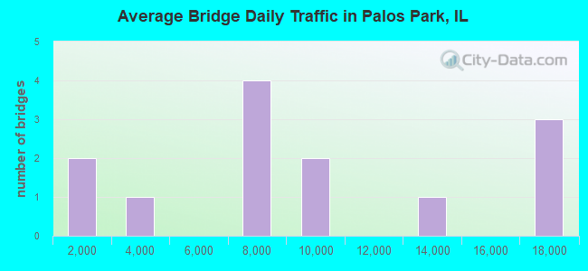
- 112,700Total average daily traffic
- 4,472Total average daily truck traffic
- National Bridge Inventory (NBI) Registered Bridges for Palos Park
- No street view available for this location
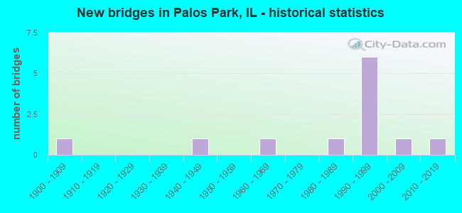
- New bridges - historical statistics
- 11900-1909
- 11940-1949
- 11960-1969
- 11980-1989
- 61990-1999
- 12000-2009
- 12010-2019
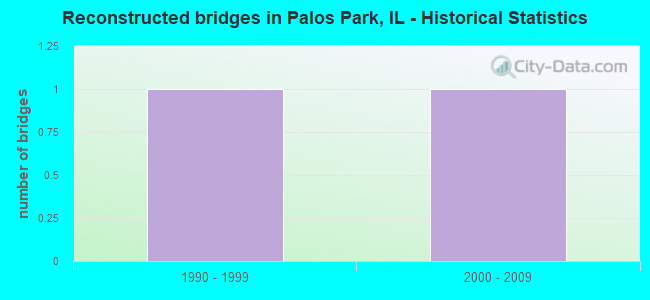
- Reconstructed bridges - Historical Statistics
- 11990-1999
- 12000-2009
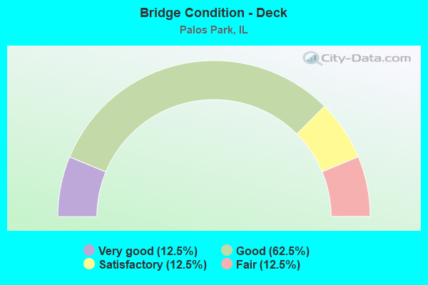
- Bridge Condition - Deck
- 12.5%Very good
- 62.5%Good
- 12.5%Satisfactory
- 12.5%Fair
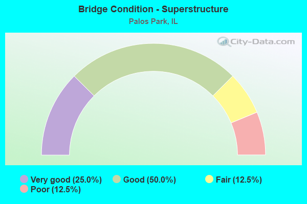
- Bridge Condition - Superstructure
- 25.0%Very good
- 50.0%Good
- 12.5%Fair
- 12.5%Poor
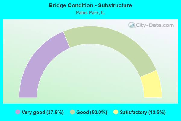
- Bridge Condition - Substructure
- 37.5%Very good
- 50.0%Good
- 12.5%Satisfactory
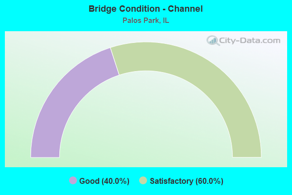
- Bridge Condition - Channel
- 40.0%Good
- 60.0%Satisfactory
Find on map >> Show street view
Structure Number: 160567, Location: 1.7 M E US 45 (Lat: 41.667508, Lng: -87.821969), Route carried "on" structure: Other road , Year Built: 1943, Year Reconstructed: 1996, Status: Open, Structure Length: 5.70m (18.70ft), Average Daily Traffic: 6,850 (year 2018), Truck Traffic: 6%, Average Future Daily Traffic: 6,592 (year 2032), Design Load: HS 20, Features Intersected: RR - METRA, Facility Carried by Structure: 123RD ST
Minimum Vertical Clearance: 30+ m (98+ ft), Kilometerpoint: 15.111, Lanes on structure: 2, Base Highway Network: Yes, Owner: State Highway Agency, Approaching Roadway Width: 13.4m (44.0ft), Skew: 3 degrees, Material/Design: Steel continuous, Design/Construction: Stringer/Multi-beam, Number Of Spans In Main Unit: 3, Length of Maximum Span: 21.6m (70.9ft), Curb or Sidewalk Widths: Left: 1.5m (4.9ft), Right: 1.5m (4.9ft), Curb-To-Curb Width: 13.4m (44.0ft), Out-to-Out Width: 17.1m (56.1ft)
Condition: Deck: Good, Superstructure: Good, Substructure: Good, Operating Rating: 81.6 metric tons, Method Used To Determine Operating Rating: Load Factor (LF) rating reported by rating factor (RF) method using MS18 loading, Inventory Rating: 48.9 metric tons, Method Used To Determine Inventory Rating: Load Factor (LF) rating reported by rating factor (RF) method using MS18 loading, Structural Evaluation: Better than present minimum criteria, Deck Geometry: Equal to present minimum criteria, Underclear: Somewhat better than minimum adequacy, Approach Roadway Alignment: Equal to present desirable criteria, Designated Inspection Frequency: Every 48 months, Inspection Date: January 2019, Deck Structure Type: Concrete Cast-file-Place, Wearing Surface/Protective System: Deck Protection: Epoxy Coated Reinforcing
Find on map >> Show street view
Structure Number: 162527, Location: 0.2 M W OF IL 7 (Lat: 41.676708, Lng: -87.819114), Route carried "on" structure: State highway 83, Year Built: 1985, Status: Open, Structure Length: 0.67m (2.20ft), Average Daily Traffic: 9,850 (year 2021), Truck Traffic: 10%, Average Future Daily Traffic: 14,832 (year 2032), Features Intersected: CREEK W OF IL 7
Minimum Vertical Clearance: 30+ m (98+ ft), Kilometerpoint: 40.168, Lanes on structure: 2, Base Highway Network: Yes, Owner: State Highway Agency, Approaching Roadway Width: 13.7m (44.9ft), Material/Design: Concrete continuous, Design/Construction: Culvert, Number Of Spans In Main Unit: 2, Length of Maximum Span: 3.0m (9.8ft)
Condition: Channel: Good, Culverts: Good, Operating Rating: 80.0 metric tons, Method Used To Determine Operating Rating: Load Factor (LF) rating reported by rating factor (RF) method using MS18 loading, Inventory Rating: 47.6 metric tons, Method Used To Determine Inventory Rating: Load Factor (LF) rating reported by rating factor (RF) method using MS18 loading, Structural Evaluation: Better than present minimum criteria, Waterway Adequacy: Equal to present desirable criteria, Approach Roadway Alignment: Equal to present desirable criteria, Designated Inspection Frequency: Every 48 months, Inspection Date: November 2018, Deck Structure Type: Other
Find on map >> Show street view
Structure Number: 162611, Location: 0.9 M E US 45 (Lat: 41.652653, Lng: -87.836844), Route carried "on" structure: Other road , Year Built: 1995, Status: Open, Structure Length: 5.49m (18.01ft), Average Daily Traffic: 6,900 (year 2021), Truck Traffic: 2%, Average Future Daily Traffic: 12,154 (year 2032), Design Load: HS 20, Features Intersected: RR - METRA, Facility Carried by Structure: 131ST ST
Minimum Vertical Clearance: 30+ m (98+ ft), Kilometerpoint: 12.713, Lanes on structure: 2, Owner: State Highway Agency, Approaching Roadway Width: 12.2m (40.0ft), Skew: 3 degrees, Material/Design: Prestressed concrete continuous, Design/Construction: Stringer/Multi-beam, Number Of Spans In Main Unit: 3, Length of Maximum Span: 23.2m (76.1ft), Curb-To-Curb Width: 12.2m (40.0ft), Out-to-Out Width: 13.2m (43.3ft)
Condition: Deck: Good, Superstructure: Fair, Substructure: Very good, Operating Rating: 64.5 metric tons, Method Used To Determine Operating Rating: Load Factor (LF) rating reported by rating factor (RF) method using MS18 loading, Inventory Rating: 40.2 metric tons, Method Used To Determine Inventory Rating: Load Factor (LF) rating reported by rating factor (RF) method using MS18 loading, Structural Evaluation: Somewhat better than minimum adequacy, Deck Geometry: Somewhat better than minimum adequacy, Underclear: Equal to present desirable criteria, Approach Roadway Alignment: Equal to present minimum criteria, Designated Inspection Frequency: Every 24 months, Inspection Date: January 2020, Deck Structure Type: Concrete Cast-file-Place, Wearing Surface/Protective System: Deck Protection: Epoxy Coated Reinforcing
Find on map >> Show street view
Structure Number: 162635, Location: 1 M SW IL 83 (Lat: 41.666311, Lng: -87.830389), Route carried "on" structure: Other road , Year Built: 1994, Status: Open, Structure Length: 2.50m (8.20ft), Average Daily Traffic: 2,750 (year 2018), Truck Traffic: 4%, Average Future Daily Traffic: 2,369 (year 2032), Features Intersected: IL 7 (W HWY), Facility Carried by Structure: 86TH AVENUE
Minimum Vertical Clearance: 30+ m (98+ ft), Kilometerpoint: 1.738, Lanes on structure: 2, Lanes under structure: 2, Owner: State Highway Agency, Approaching Roadway Width: 10.4m (34.1ft), Skew: 4 degrees, Material/Design: Steel, Design/Construction: Stringer/Multi-beam, Number Of Spans In Main Unit: 1, Length of Maximum Span: 24.5m (80.4ft), Curb-To-Curb Width: 10.4m (34.1ft), Out-to-Out Width: 11.3m (37.1ft)
Condition: Deck: Satisfactory, Superstructure: Good, Substructure: Good, Operating Rating: 85.5 metric tons, Method Used To Determine Operating Rating: Load Factor (LF) rating reported by rating factor (RF) method using MS18 loading, Inventory Rating: 51.5 metric tons, Method Used To Determine Inventory Rating: Load Factor (LF) rating reported by rating factor (RF) method using MS18 loading, Structural Evaluation: Better than present minimum criteria, Deck Geometry: Somewhat better than minimum adequacy, Underclear: Better than present minimum criteria, Approach Roadway Alignment: Equal to present desirable criteria, Designated Inspection Frequency: Every 48 months, Inspection Date: January 2019, Deck Structure Type: Concrete Cast-file-Place, Wearing Surface/Protective System: Deck Protection: Epoxy Coated Reinforcing
Find on map >> Show street view
Structure Number: 162636, Location: 0.9 M SW IL 83 (Lat: 41.667381, Lng: -87.828958), Route carried "on" structure: Other road , Year Built: 1996, Status: Open, Structure Length: 2.84m (9.32ft), Average Daily Traffic: 6,850 (year 2018), Truck Traffic: 6%, Average Future Daily Traffic: 6,592 (year 2032), Design Load: HS 20, Features Intersected: IL 7 (SW HWY), Facility Carried by Structure: 123RD ST
Minimum Vertical Clearance: 30+ m (98+ ft), Kilometerpoint: 14.516, Lanes on structure: 2, Lanes under structure: 2, Base Highway Network: Yes, Owner: State Highway Agency, Approaching Roadway Width: 13.4m (44.0ft), Material/Design: Steel, Design/Construction: Stringer/Multi-beam, Number Of Spans In Main Unit: 1, Length of Maximum Span: 27.8m (91.2ft), Curb or Sidewalk Widths: Left: 1.5m (4.9ft), Right: 1.5m (4.9ft), Curb-To-Curb Width: 13.4m (44.0ft), Out-to-Out Width: 17.8m (58.4ft)
Condition: Deck: Good, Superstructure: Good, Substructure: Good, Operating Rating: 81.0 metric tons, Method Used To Determine Operating Rating: Load Factor (LF) rating reported by rating factor (RF) method using MS18 loading, Inventory Rating: 48.6 metric tons, Method Used To Determine Inventory Rating: Load Factor (LF) rating reported by rating factor (RF) method using MS18 loading, Structural Evaluation: Better than present minimum criteria, Deck Geometry: Equal to present minimum criteria, Underclear: High priority of corrective action, Approach Roadway Alignment: Equal to present desirable criteria, Designated Inspection Frequency: Every 48 months, Inspection Date: January 2019, Deck Structure Type: Concrete Cast-file-Place, Wearing Surface/Protective System: Deck Protection: Epoxy Coated Reinforcing
Find on map >> Show street view
Structure Number: 162667, Location: 1.4 M W US 45 (Lat: 41.686914, Lng: -87.881881), Route carried "on" structure: State highway 83, Year Built: 1999, Status: Open, Structure Length: 1.86m (6.10ft), Average Daily Traffic: 12,400 (year 2021), Truck Traffic: 8%, Average Future Daily Traffic: 13,493 (year 2032), Design Load: HS 20+Mod, Features Intersected: CREEK W OF 104TH AVE
Minimum Vertical Clearance: 30+ m (98+ ft), Kilometerpoint: 45.736, Lanes on structure: 2, Base Highway Network: Yes, Owner: State Highway Agency, Approaching Roadway Width: 7.3m (24.0ft), Skew: 1 degrees, Material/Design: Prestressed concrete, Design/Construction: Stringer/Multi-beam, Number Of Spans In Main Unit: 1, Length of Maximum Span: 17.8m (58.4ft), Curb-To-Curb Width: 12.2m (40.0ft), Out-to-Out Width: 13.2m (43.3ft)
Condition: Deck: Good, Superstructure: Very good, Substructure: Very good, Channel: Satisfactory, Operating Rating: 73.9 metric tons, Method Used To Determine Operating Rating: Load Factor (LF) rating reported by rating factor (RF) method using MS18 loading, Inventory Rating: 45.7 metric tons, Method Used To Determine Inventory Rating: Load Factor (LF) rating reported by rating factor (RF) method using MS18 loading, Structural Evaluation: Equal to present desirable criteria, Deck Geometry: Somewhat better than minimum adequacy, Waterway Adequacy: Equal to present desirable criteria, Approach Roadway Alignment: Equal to present desirable criteria, Designated Inspection Frequency: Every 48 months, Inspection Date: November 2018, Deck Structure Type: Concrete Cast-file-Place, Wearing Surface/Protective System: Deck Protection: Epoxy Coated Reinforcing
Find on map >> Show street view
Structure Number: 162769, Location: 0.4 M S OF IL 83 (Lat: 41.676644, Lng: -87.844075), Route carried "on" structure: Other road , Year Built: 2002, Status: Open, Structure Length: 1.62m (5.31ft), Average Daily Traffic: 275 (year 2021), Truck Traffic: 1%, Average Future Daily Traffic: 206 (year 2032), Features Intersected: MILL CREEK, Facility Carried by Structure: KEAN AVE
Minimum Vertical Clearance: 30+ m (98+ ft), Kilometerpoint: 0.724, Lanes on structure: 2, Owner: State Highway Agency, Approaching Roadway Width: 9.2m (30.2ft), Material/Design: Steel, Design/Construction: Stringer/Multi-beam, Number Of Spans In Main Unit: 1, Length of Maximum Span: 15.3m (50.2ft), Curb-To-Curb Width: 9.2m (30.2ft), Out-to-Out Width: 10.2m (33.5ft)
Condition: Deck: Very good, Superstructure: Good, Substructure: Very good, Channel: Satisfactory, Operating Rating: 89.1 metric tons, Method Used To Determine Operating Rating: Load Factor (LF) rating reported by rating factor (RF) method using MS18 loading, Inventory Rating: 67.1 metric tons, Method Used To Determine Inventory Rating: Load Factor (LF) rating reported by rating factor (RF) method using MS18 loading, Structural Evaluation: Better than present minimum criteria, Deck Geometry: Equal to present minimum criteria, Waterway Adequacy: Superior to present desirable criteria, Approach Roadway Alignment: Equal to present desirable criteria, Designated Inspection Frequency: Every 48 months, Inspection Date: November 2018, Deck Structure Type: Concrete Cast-file-Place, Wearing Surface/Protective System: Deck Protection: Epoxy Coated Reinforcing
Find on map >> Show street view
Structure Number: 162831, Location: 0.6 M E US 45 (Lat: 41.674339, Lng: -87.842969), Route carried "on" structure: Other road , Year Built: 2012, Status: Open, Structure Length: 2.19m (7.19ft), Average Daily Traffic: 975 (year 2021), Truck Traffic: 6%, Average Future Daily Traffic: 2,150 (year 2036), Features Intersected: MILL CREEK, Facility Carried by Structure: 119TH ST
Minimum Vertical Clearance: 30+ m (98+ ft), Kilometerpoint: 0.998, Lanes on structure: 2, Owner: State Highway Agency, Approaching Roadway Width: 13.1m (43.0ft), Material/Design: Prestressed concrete, Design/Construction: Stringer/Multi-beam, Number Of Spans In Main Unit: 1, Length of Maximum Span: 21.2m (69.6ft), Curb-To-Curb Width: 13.1m (43.0ft), Out-to-Out Width: 14.0m (45.9ft)
Condition: Deck: Good, Superstructure: Very good, Substructure: Good, Channel: Satisfactory, Operating Rating: 73.2 metric tons, Method Used To Determine Operating Rating: Load Factor (LF) rating reported by rating factor (RF) method using MS18 loading, Inventory Rating: 44.4 metric tons, Method Used To Determine Inventory Rating: Load Factor (LF) rating reported by rating factor (RF) method using MS18 loading, Structural Evaluation: Better than present minimum criteria, Deck Geometry: Superior to present desirable criteria, Waterway Adequacy: Equal to present desirable criteria, Approach Roadway Alignment: Equal to present desirable criteria, Designated Inspection Frequency: Every 48 months, Inspection Date: August 2018, Deck Structure Type: Concrete Cast-file-Place, Wearing Surface/Protective System: Deck Protection: Epoxy Coated Reinforcing
Find on map >> Show street view
Structure Number: 163018, Location: 0.5 M S 107TH P19 (Lat: 41.688228, Lng: -87.874853), Route carried "on" structure: Other road , Year Built: 1964, Year Reconstructed: 2014, Status: Open, Structure Length: 12.37m (40.58ft), Average Daily Traffic: 9,700 (year 2018), Truck Traffic: 1%, Average Future Daily Traffic: 8,549 (year 2032), Design Load: H 20, Features Intersected: CAL SAG CHANNEL, Facility Carried by Structure: 104TH AVE
Minimum Vertical Clearance: 30+ m (98+ ft), Kilometerpoint: 15.095, Lanes on structure: 2, Base Highway Network: Yes, Owner: County Highway Agency, Approaching Roadway Width: 8.5m (27.9ft), Navigation Control: Yes ( Vertical Clearance: 7.3m (24.0ft), Horizontal Clearance: 68.6m (225.1ft)), Material/Design: Steel, Design/Construction: Truss - Thru, Number Of Spans In Main Unit: 1, Number Of Approach Spans: 4, Length of Maximum Span: 88.4m (290.0ft), Curb or Sidewalk Widths: Left: 1.5m (4.9ft), Right: 1.5m (4.9ft), Curb-To-Curb Width: 8.5m (27.9ft), Out-to-Out Width: 13.7m (44.9ft)
Condition: Deck: Fair, Superstructure: Poor, Substructure: Satisfactory, Channel: Good, Operating Rating: 51.2 metric tons, Method Used To Determine Operating Rating: Load Factor (LF) rating reported by rating factor (RF) method using MS18 loading, Inventory Rating: 30.8 metric tons, Method Used To Determine Inventory Rating: Load Factor (LF) rating reported by rating factor (RF) method using MS18 loading, Structural Evaluation: Meets minimum limits, Deck Geometry: Meets minimum limits, Waterway Adequacy: Superior to present desirable criteria, Approach Roadway Alignment: Equal to present desirable criteria, Designated Inspection Frequency: Every 24 months, Critical Feature Inspection Frequency: Every 12 months, Inspection Date: April 2021, Critical Feature Inspection Date: April 2021, Deck Structure Type: Concrete Cast-file-Place, Wearing Surface/Protective System: Wearing Surface: Latex Concrete, Deck Protection: Cathodic Protection
Find on map >> Show street view
Structure Number: 162635, Location: 1 M SW IL 83 (Lat: 41.666311, Lng: -87.830389), Route carried "under" structure: State highway 7, Year Built: 1994, Structure Length: 0. m, Average Daily Traffic: 16,300 (year 2021), Truck Traffic: 2%, Features Intersected: IL 7 (W HWY), Facility Carried by Structure: 86TH AVENUE
Minimum Vertical Clearance: 4.45m (14.60ft), Kilometerpoint: 40.603, Lanes on structure: 2, Lanes under structure: 2, Material/Design: Steel, Design/Construction: Stringer/Multi-beam, Length of Maximum Span: 24.5m (80.4ft)
Find on map >> Show street view
Structure Number: 162636, Location: 0.9 M SW IL 83 (Lat: 41.667381, Lng: -87.828958), Route carried "under" structure: State highway 7, Year Built: 1996, Structure Length: 0. m, Average Daily Traffic: 16,300 (year 2021), Truck Traffic: 2%, Features Intersected: IL 7 (SW HWY), Facility Carried by Structure: 123RD ST
Minimum Vertical Clearance: 4.42m (14.50ft), Kilometerpoint: 40.780, Lanes on structure: 2, Lanes under structure: 2, Material/Design: Steel, Design/Construction: Stringer/Multi-beam, Length of Maximum Span: 27.8m (91.2ft)
Find on map >> Show street view
Structure Number: 162677, Location: 0.3 M N of 131st (Lat: 41.656833, Lng: -87.838850), Route carried "under" structure: State highway 7, Structure Length: 0. m, Average Daily Traffic: 16,300 (year 2021), Truck Traffic: 2%, Features Intersected: IL 7 SOUTHWEST HWY, Facility Carried by Structure: PEDESTRIAN BRIDGE
Minimum Vertical Clearance: 5.03m (16.50ft), Kilometerpoint: 39.283, Lanes under structure: 4, Material/Design: Wood or Timber, Design/Construction: Truss - Deck, Length of Maximum Span: 0.0m
Find on map >> Show street view
Structure Number: 163022, Location: AT 120TH P19 (Lat: 41.672969, Lng: -87.816097), Route carried "under" structure: Other road , Year Built: 1900, Structure Length: 0. m, Average Daily Traffic: 7,250 (year 2018), Truck Traffic: 4%, Features Intersected: 80TH AVE, Facility Carried by Structure: N&W RR
Minimum Vertical Clearance: 3.63m (11.91ft), Kilometerpoint: 0.193, Lanes under structure: 2, Material/Design: Steel, Length of Maximum Span: 9.8m (32.2ft)