Bridge Statistics for Parkway-South Sacramento, California (CA)
Condition, Traffic, Stress, Structural Evaluation, Project Costs
- National Bridge Inventory (NBI) Statistics
- 14Number of bridges
- 128ft / 39.2mTotal length
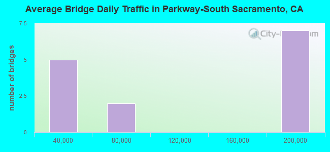
- 1,433,274Total average daily traffic
- 84,521Total average daily truck traffic
- National Bridge Inventory (NBI) Registered Bridges for Parkway-South Sacramento
- No street view available for this location
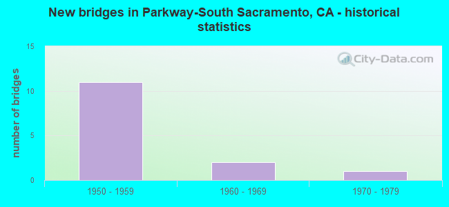
- New bridges - historical statistics
- 111950-1959
- 21960-1969
- 11970-1979

- Bridge Condition - Deck
- 83.3%Good
- 16.7%Satisfactory
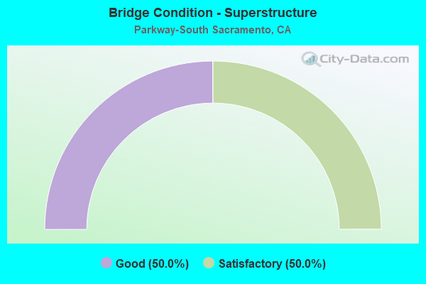
- Bridge Condition - Superstructure
- 50.0%Good
- 50.0%Satisfactory
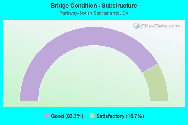
- Bridge Condition - Substructure
- 83.3%Good
- 16.7%Satisfactory
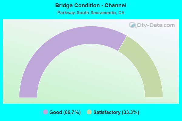
- Bridge Condition - Channel
- 66.7%Good
- 33.3%Satisfactory
Find on map >> Show street view
Structure Number: 24 0146, Location: 03-SAC-099-21.27 (Lat: 38.515817, Lng: -121.463250), Route carried "on" structure: County highway , Year Built: 1959, Status: Open, Structure Length: 6.77m (22.21ft), Average Daily Traffic: 4,310 (year 2009), Truck Traffic: 2%, Average Future Daily Traffic: 7,103 (year 2044), Design Load: HS 20, Features Intersected: STATE ROUTE 99, Facility Carried by Structure: 41ST AVE
Minimum Vertical Clearance: 30+ m (98+ ft), Kilometerpoint: 0.000, Lanes on structure: 2, Lanes under structure: 10, Owner: State Highway Agency, Approaching Roadway Width: 8.6m (28.2ft), Skew: 2 degrees, Material/Design: Concrete continuous, Design/Construction: Box Beam or Girders - Multiple, Number Of Spans In Main Unit: 4, Length of Maximum Span: 23.2m (76.1ft), Curb or Sidewalk Widths: Left: 1.4m (4.6ft), Right: 1.4m (4.6ft), Curb-To-Curb Width: 8.6m (28.2ft), Out-to-Out Width: 12.3m (40.4ft)
Condition: Deck: Good, Superstructure: Satisfactory, Substructure: Good, Operating Rating: 37.3 metric tons, Method Used To Determine Operating Rating: Load and Resistance Factor Rating (LRFR) rating reported by rating factor(RF) method using HL-93 loadings, Inventory Rating: 26.6 metric tons, Method Used To Determine Inventory Rating: Load and Resistance Factor Rating (LRFR) rating reported by rating factor(RF) method using HL-93 loadings, Structural Evaluation: Equal to present minimum criteria, Deck Geometry: Meets minimum limits, Underclear: Meets minimum limits, Approach Roadway Alignment: Equal to present desirable criteria, Designated Inspection Frequency: Every 24 months, Inspection Date: Febuary 2022, Deck Structure Type: Concrete Cast-file-Place, Wearing Surface/Protective System: Wearing Surface: Bituminous
Find on map >> Show street view
Structure Number: 24 0147, Location: 03-SAC-099-21.57 (Lat: 38.519517, Lng: -121.465222), Route carried "on" structure: County highway , Year Built: 1959, Status: Open, Structure Length: 9.91m (32.51ft), Average Daily Traffic: 15,720 (year 1998), Truck Traffic: 2%, Average Future Daily Traffic: 23,673 (year 2044), Design Load: HS 20, Features Intersected: STATE ROUTE 99, Facility Carried by Structure: MARTIN LUTHER KING
Minimum Vertical Clearance: 30+ m (98+ ft), Kilometerpoint: 0.000, Lanes on structure: 2, Lanes under structure: 10, Owner: State Highway Agency, Approaching Roadway Width: 11.5m (37.7ft), Skew: 4 degrees, Material/Design: Concrete continuous, Design/Construction: Box Beam or Girders - Multiple, Number Of Spans In Main Unit: 4, Length of Maximum Span: 35.7m (117.1ft), Curb or Sidewalk Widths: Left: 1.6m (5.2ft), Right: 0.3m (1.0ft), Curb-To-Curb Width: 11.5m (37.7ft), Out-to-Out Width: 14.0m (45.9ft)
Condition: Deck: Satisfactory, Superstructure: Good, Substructure: Good, Operating Rating: 36.6 metric tons, Method Used To Determine Operating Rating: Load and Resistance Factor Rating (LRFR) rating reported by rating factor(RF) method using HL-93 loadings, Inventory Rating: 28.2 metric tons, Method Used To Determine Inventory Rating: Load and Resistance Factor Rating (LRFR) rating reported by rating factor(RF) method using HL-93 loadings, Structural Evaluation: Better than present minimum criteria, Deck Geometry: Meets minimum limits, Underclear: High priority of corrective action, Approach Roadway Alignment: Better than present minimum criteria, Designated Inspection Frequency: Every 24 months, Inspection Date: Febuary 2022, Deck Structure Type: Concrete Cast-file-Place
Find on map >> Show street view
Structure Number: 24 0152, Location: 03-SAC-099-20.86 (Lat: 38.510378, Lng: -121.460392), Route carried "on" structure: County highway , Year Built: 1959, Status: Open, Structure Length: 7.74m (25.39ft), Average Daily Traffic: 36,380 (year 1998), Truck Traffic: 2%, Average Future Daily Traffic: 56,865 (year 2042), Design Load: HS 20, Features Intersected: STATE ROUTE 99, Facility Carried by Structure: 47TH AVE
Minimum Vertical Clearance: 30+ m (98+ ft), Kilometerpoint: 0.000, Lanes on structure: 4, Lanes under structure: 10, Owner: State Highway Agency, Approaching Roadway Width: 17.5m (57.4ft), Skew: 22 degrees, Material/Design: Concrete continuous, Design/Construction: Box Beam or Girders - Multiple, Number Of Spans In Main Unit: 4, Length of Maximum Span: 27.7m (90.9ft), Curb or Sidewalk Widths: Left: 1.4m (4.6ft), Right: 1.4m (4.6ft), Curb-To-Curb Width: 17.5m (57.4ft), Out-to-Out Width: 20.7m (67.9ft)
Condition: Deck: Good, Superstructure: Satisfactory, Substructure: Good, Operating Rating: 43.1 metric tons, Method Used To Determine Operating Rating: Load and Resistance Factor Rating (LRFR) rating reported by rating factor(RF) method using HL-93 loadings, Inventory Rating: 30.8 metric tons, Method Used To Determine Inventory Rating: Load and Resistance Factor Rating (LRFR) rating reported by rating factor(RF) method using HL-93 loadings, Structural Evaluation: Equal to present minimum criteria, Deck Geometry: Somewhat better than minimum adequacy, Underclear: Meets minimum limits, Approach Roadway Alignment: Better than present minimum criteria, Designated Inspection Frequency: Every 24 months, Inspection Date: Febuary 2022, Deck Structure Type: Concrete Cast-file-Place, Wearing Surface/Protective System: Wearing Surface: Bituminous
Find on map >> Show street view
Structure Number: 24 0167, Location: 03-SAC-099-19.62 (Lat: 38.496200, Lng: -121.446547), Route carried "on" structure: County highway , Year Built: 1959, Year Reconstructed: 1973, Status: Open, Structure Length: 8.87m (29.10ft), Average Daily Traffic: 55,000 (year 1998), Truck Traffic: 2%, Average Future Daily Traffic: 120,507 (year 2042), Design Load: HS 20, Features Intersected: STATE ROUTE 99, Facility Carried by Structure: FLORIN ROAD WB
Minimum Vertical Clearance: 5.79m (19.00ft), Kilometerpoint: 0.000, Lanes on structure: 4, Lanes under structure: 8, Base Highway Network: Yes, Owner: State Highway Agency, Approaching Roadway Width: 15.8m (51.8ft), Skew: 4 degrees, Material/Design: Concrete continuous, Design/Construction: Box Beam or Girders - Multiple, Number Of Spans In Main Unit: 4, Length of Maximum Span: 31.1m (102.0ft), Curb or Sidewalk Widths: Left: 1.5m (4.9ft), Right: 0.6m (2.0ft), Curb-To-Curb Width: 15.8m (51.8ft), Out-to-Out Width: 18.6m (61.0ft)
Condition: Deck: Good, Superstructure: Satisfactory, Substructure: Satisfactory, Operating Rating: 93.6 metric tons, Method Used To Determine Operating Rating: Load Factor (LF), Inventory Rating: 32.4 metric tons, Method Used To Determine Inventory Rating: Load Factor (LF), Structural Evaluation: Equal to present minimum criteria, Deck Geometry: Meets minimum limits, Underclear: High priority of corrective action, Approach Roadway Alignment: Better than present minimum criteria, Designated Inspection Frequency: Every 24 months, Inspection Date: Febuary 2022, Deck Structure Type: Concrete Cast-file-Place, Wearing Surface/Protective System: Wearing Surface: Bituminous
Find on map >> Show street view
Structure Number: 24C019, Location: 0.1 MI N OF OAK AVE (Lat: 38.701361, Lng: -121.224919), Route carried "on" structure: County highway , Year Built: 1974, Status: Open, Structure Length: 0.98m (3.22ft), Average Daily Traffic: 39,286 (year 2004), Truck Traffic: 10%, Average Future Daily Traffic: 91,609 (year 2037), Features Intersected: LINDA CREEK, Facility Carried by Structure: HAZEL AVENUE
Minimum Vertical Clearance: 30+ m (98+ ft), Kilometerpoint: 0.000, Lanes on structure: 4, Base Highway Network: Yes, Owner: County Highway Agency, Approaching Roadway Width: 16.5m (54.1ft), Skew: 20 degrees, Material/Design: Concrete continuous, Design/Construction: Culvert, Number Of Spans In Main Unit: 3, Length of Maximum Span: 3.0m (9.8ft), Curb or Sidewalk Widths: Left: 0.0m, Right: 3.6m (11.8ft), Curb-To-Curb Width: 18.6m (61.0ft), Out-to-Out Width: 26.4m (86.6ft)
Condition: Channel: Good, Culverts: Satisfactory, Operating Rating: 54.1 metric tons, Method Used To Determine Operating Rating: Field evaluation and documented engineering judgment, Inventory Rating: 32.4 metric tons, Method Used To Determine Inventory Rating: Field evaluation and documented engineering judgment, Structural Evaluation: Equal to present minimum criteria, Deck Geometry: Equal to present minimum criteria, Waterway Adequacy: Superior to present desirable criteria, Approach Roadway Alignment: Equal to present desirable criteria, Designated Inspection Frequency: Every 48 months, Inspection Date: April 2019
Find on map >> Show street view
Structure Number: 24C0194, Location: 100 FT W OF EAST PKWY (Lat: 38.495953, Lng: -121.451731), Route carried "on" structure: County highway , Year Built: 1956, Year Reconstructed: 1971, Status: Open, Structure Length: 2.50m (8.20ft), Average Daily Traffic: 42,128 (year 2013), Truck Traffic: 10%, Average Future Daily Traffic: 66,404 (year 2038), Design Load: HS 20, Features Intersected: MORRISON CREEK, Facility Carried by Structure: FLORIN RD
Minimum Vertical Clearance: 30+ m (98+ ft), Kilometerpoint: 0.000, Lanes on structure: 7, Base Highway Network: Yes, Owner: County Highway Agency, Approaching Roadway Width: 28.6m (93.8ft), Skew: 30 degrees, Material/Design: Concrete continuous, Design/Construction: Slab, Number Of Spans In Main Unit: 4, Length of Maximum Span: 6.1m (20.0ft), Curb or Sidewalk Widths: Left: 1.5m (4.9ft), Right: 1.5m (4.9ft), Curb-To-Curb Width: 28.6m (93.8ft), Out-to-Out Width: 33.1m (108.6ft)
Condition: Deck: Good, Superstructure: Good, Substructure: Good, Channel: Satisfactory, Operating Rating: 25.6 metric tons, Method Used To Determine Operating Rating: Load and Resistance Factor Rating (LRFR) rating reported by rating factor(RF) method using HL-93 loadings, Inventory Rating: 17.8 metric tons, Method Used To Determine Inventory Rating: Load and Resistance Factor Rating (LRFR) rating reported by rating factor(RF) method using HL-93 loadings, Structural Evaluation: Meets minimum limits, Deck Geometry: Somewhat better than minimum adequacy, Waterway Adequacy: Superior to present desirable criteria, Approach Roadway Alignment: Equal to present desirable criteria, Designated Inspection Frequency: Every 24 months, Inspection Date: April 2020, Deck Structure Type: Concrete Cast-file-Place, Wearing Surface/Protective System: Wearing Surface: Bituminous
Find on map >> Show street view
Structure Number: 24C0389, Location: SOUTH OF 53RD AVE (Lat: 38.502928, Lng: -121.441944), Route carried "on" structure: County highway , Year Built: 1961, Status: Open, Structure Length: 2.47m (8.10ft), Average Daily Traffic: 5,450 (year 2007), Truck Traffic: 1%, Average Future Daily Traffic: 7,531 (year 2042), Design Load: HS 20, Features Intersected: MORRISON CREEK, Facility Carried by Structure: STEINER RD
Minimum Vertical Clearance: 30+ m (98+ ft), Kilometerpoint: 0.000, Lanes on structure: 2, Owner: County Highway Agency, Approaching Roadway Width: 14.0m (45.9ft), Material/Design: Concrete continuous, Design/Construction: Slab, Number Of Spans In Main Unit: 4, Length of Maximum Span: 6.1m (20.0ft), Curb or Sidewalk Widths: Left: 1.5m (4.9ft), Right: 1.5m (4.9ft), Curb-To-Curb Width: 14.2m (46.6ft), Out-to-Out Width: 17.9m (58.7ft)
Condition: Deck: Good, Superstructure: Good, Substructure: Good, Channel: Good, Operating Rating: 28.5 metric tons, Method Used To Determine Operating Rating: Load and Resistance Factor Rating (LRFR) rating reported by rating factor(RF) method using HL-93 loadings, Inventory Rating: 22.0 metric tons, Method Used To Determine Inventory Rating: Load and Resistance Factor Rating (LRFR) rating reported by rating factor(RF) method using HL-93 loadings, Structural Evaluation: Somewhat better than minimum adequacy, Deck Geometry: Superior to present desirable criteria, Waterway Adequacy: Better than present minimum criteria, Approach Roadway Alignment: Equal to present desirable criteria, Designated Inspection Frequency: Every 24 months, Inspection Date: November 2020, Deck Structure Type: Concrete Cast-file-Place, Wearing Surface/Protective System: Wearing Surface: Bituminous
Find on map >> Show street view
Structure Number: 24 0145, Location: 03-SAC-099-21.10 (Lat: 38.513386, Lng: -121.461939), Route carried "under" structure: State highway 99, Year Built: 1959, Structure Length: 0. m, Average Daily Traffic: 179,000 (year 2009), Truck Traffic: 6%, Features Intersected: STATE ROUTE 99, Facility Carried by Structure: 44TH AVE POC
Minimum Vertical Clearance: 4.35m (14.27ft), Kilometerpoint: 21.100, Lanes under structure: 8, Material/Design: Prestressed concrete continuous, Design/Construction: Slab, Length of Maximum Span: 24.4m (80.1ft)
Find on map >> Show street view
Structure Number: 24 0146, Location: 03-SAC-099-21.27 (Lat: 38.515817, Lng: -121.463250), Route carried "under" structure: State highway 99, Year Built: 1959, Structure Length: 0. m, Average Daily Traffic: 179,000 (year 2009), Truck Traffic: 6%, Features Intersected: STATE ROUTE 99, Facility Carried by Structure: 41ST AVE
Minimum Vertical Clearance: 4.82m (15.81ft), Kilometerpoint: 21.270, Lanes on structure: 2, Lanes under structure: 10, Material/Design: Concrete continuous, Design/Construction: Box Beam or Girders - Multiple, Length of Maximum Span: 23.2m (76.1ft)
Find on map >> Show street view
Structure Number: 24 0147, Location: 03-SAC-099-21.57 (Lat: 38.519517, Lng: -121.465222), Route carried "under" structure: State highway 99, Year Built: 1959, Structure Length: 0. m, Average Daily Traffic: 179,000 (year 2009), Truck Traffic: 6%, Features Intersected: STATE ROUTE 99, Facility Carried by Structure: MARTIN LUTHER KING
Minimum Vertical Clearance: 4.54m (14.90ft), Kilometerpoint: 21.570, Lanes on structure: 2, Lanes under structure: 10, Material/Design: Concrete continuous, Design/Construction: Box Beam or Girders - Multiple, Length of Maximum Span: 35.7m (117.1ft)
Find on map >> Show street view
Structure Number: 24 015, Location: 03-SAC-099-19.61 (Lat: 38.496006, Lng: -121.446406), Route carried "under" structure: State highway 99, Year Built: 1959, Structure Length: 0. m, Average Daily Traffic: 161,000 (year 2009), Truck Traffic: 6%, Features Intersected: STATE ROUTE 99, Facility Carried by Structure: FLORIN ROAD EB
Minimum Vertical Clearance: 4.47m (14.67ft), Kilometerpoint: 19.610, Lanes on structure: 4, Lanes under structure: 8, Material/Design: Concrete continuous, Design/Construction: Box Beam or Girders - Multiple, Length of Maximum Span: 31.1m (102.0ft)
Find on map >> Show street view
Structure Number: 24 0152, Location: 03-SAC-099-20.86 (Lat: 38.510378, Lng: -121.460392), Route carried "under" structure: State highway 99, Year Built: 1959, Structure Length: 0. m, Average Daily Traffic: 179,000 (year 2009), Truck Traffic: 6%, Features Intersected: STATE ROUTE 99, Facility Carried by Structure: 47TH AVE
Minimum Vertical Clearance: 4.57m (14.99ft), Kilometerpoint: 20.860, Lanes on structure: 4, Lanes under structure: 10, Material/Design: Concrete continuous, Design/Construction: Box Beam or Girders - Multiple, Length of Maximum Span: 27.7m (90.9ft)
Find on map >> Show street view
Structure Number: 24 0167, Location: 03-SAC-099-19.62 (Lat: 38.496200, Lng: -121.446547), Route carried "under" structure: State highway 99, Year Built: 1959, Structure Length: 0. m, Average Daily Traffic: 179,000 (year 2009), Truck Traffic: 6%, Features Intersected: STATE ROUTE 99, Facility Carried by Structure: FLORIN ROAD WB
Minimum Vertical Clearance: 4.47m (14.67ft), Kilometerpoint: 19.620, Lanes on structure: 4, Lanes under structure: 8, Material/Design: Concrete continuous, Design/Construction: Box Beam or Girders - Multiple, Length of Maximum Span: 31.1m (102.0ft)
Find on map >> Show street view
Structure Number: 24 0169, Location: 03-SAC-099-20.18 (Lat: 38.502381, Lng: -121.453058), Route carried "under" structure: State highway 99, Year Built: 1961, Structure Length: 0. m, Average Daily Traffic: 179,000 (year 2009), Truck Traffic: 6%, Features Intersected: STATE ROUTE 99, Facility Carried by Structure: PEDESTRIAN WALKWAY
Minimum Vertical Clearance: 4.57m (14.99ft), Kilometerpoint: 20.180, Lanes under structure: 8, Material/Design: Prestressed concrete continuous, Design/Construction: Slab, Length of Maximum Span: 21.3m (69.9ft)