Bridge Statistics for Patterson, Georgia (GA)
Condition, Traffic, Stress, Structural Evaluation, Project Costs
- National Bridge Inventory (NBI) Statistics
- 15Number of bridges
- 85ft / 26.0mTotal length
- $9,387,000Total costs
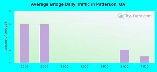
- 28,540Total average daily traffic
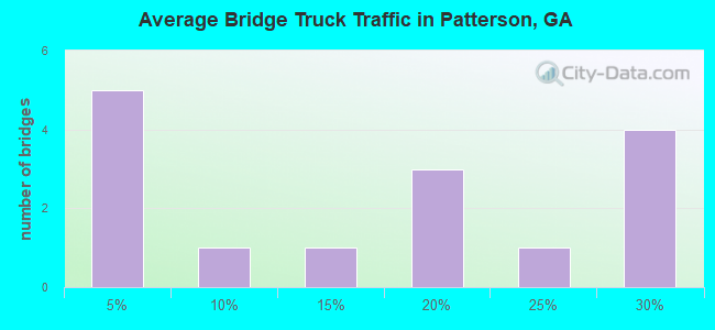
- 4,710Total average daily truck traffic
- 42,810Total future (year 2031) average daily traffic
- National Bridge Inventory (NBI) Registered Bridges for Patterson
- No street view available for this location
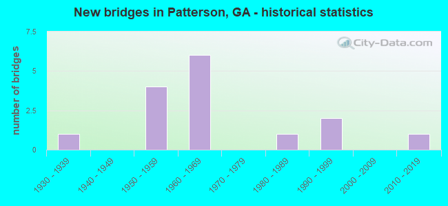
- New bridges - historical statistics
- 11930-1939
- 41950-1959
- 61960-1969
- 11980-1989
- 21990-1999
- 12010-2019
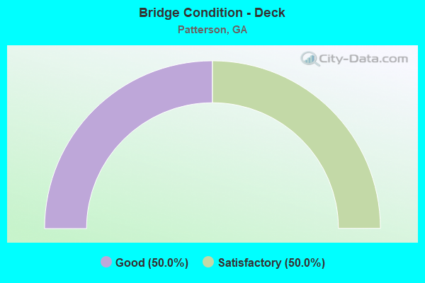
- Bridge Condition - Deck
- 50.0%Good
- 50.0%Satisfactory
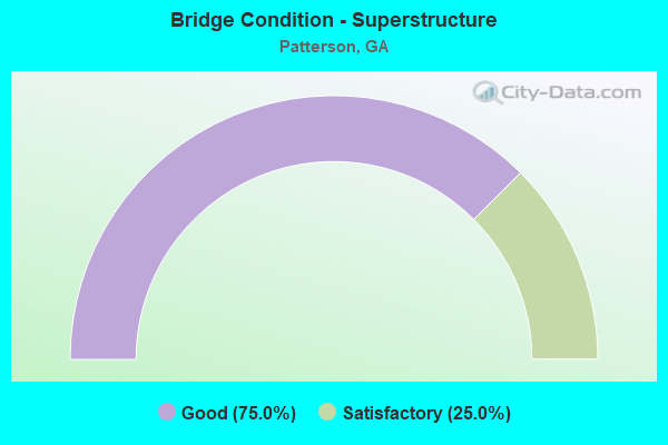
- Bridge Condition - Superstructure
- 75.0%Good
- 25.0%Satisfactory
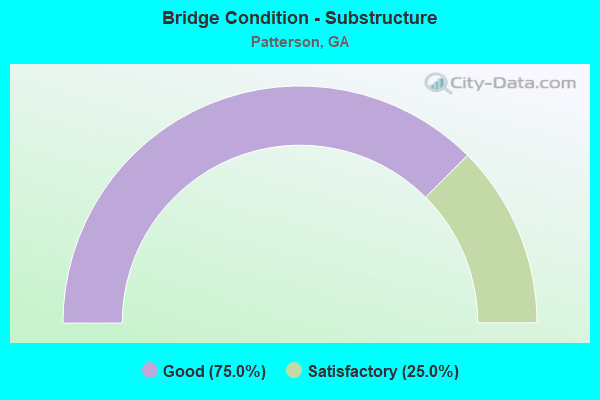
- Bridge Condition - Substructure
- 75.0%Good
- 25.0%Satisfactory
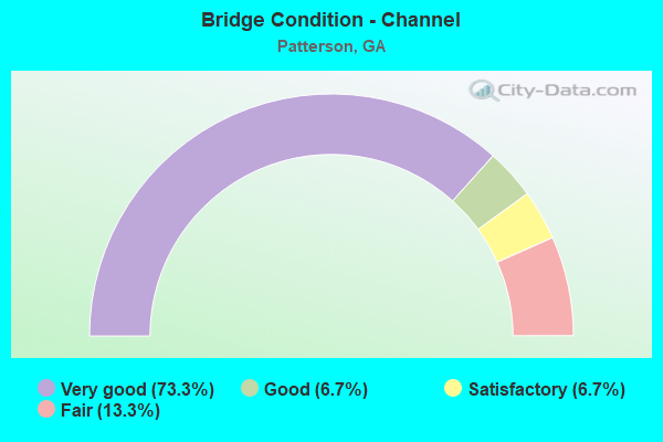
- Bridge Condition - Channel
- 73.3%Very good
- 6.7%Good
- 6.7%Satisfactory
- 13.3%Fair
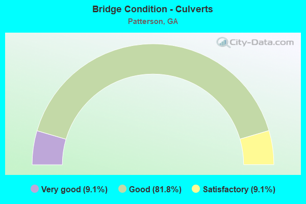
- Bridge Condition - Culverts
- 9.1%Very good
- 81.8%Good
- 9.1%Satisfactory
Find on map >> Show street view
Structure Number: 1551, Location: 2.7 MI N OF TAYLORSVILLE (Lat: 34.123919, Lng: -85.001308), Route carried "on" structure: County highway 47, Year Built: 1998, Status: Open, Structure Length: 1.07m (3.51ft), Average Daily Traffic: 600 (year 2011), Truck Traffic: 1%, Average Future Daily Traffic: 900 (year 2031), Design Load: H 15, Features Intersected: JONES BRANCH, Facility Carried by Structure: POPHAM ROAD
Minimum Vertical Clearance: 30+ m (98+ ft), Kilometerpoint: 0.000, Lanes on structure: 2, Base Highway Network: Yes, Owner: County Highway Agency, Approaching Roadway Width: 5.5m (18.0ft), Material/Design: Steel, Design/Construction: Culvert, Number Of Spans In Main Unit: 4, Length of Maximum Span: 1.8m (5.9ft)
Condition: Channel: Very good, Culverts: Good, Operating Rating: 41.7 metric tons, Method Used To Determine Operating Rating: Field evaluation and documented engineering judgment, Inventory Rating: 24.4 metric tons, Method Used To Determine Inventory Rating: Field evaluation and documented engineering judgment, Structural Evaluation: Equal to present minimum criteria, Waterway Adequacy: Equal to present minimum criteria, Approach Roadway Alignment: Equal to present desirable criteria, Designated Inspection Frequency: Every 24 months, Inspection Date: July 2020, Bridge Improvement Cost: $137,000, Roadway Improvement Cost: $14,000, Total Project Cost: $205,000
Find on map >> Show street view
Structure Number: 2290012, Location: 4 MI E OF PATTERSON (Lat: 31.361128, Lng: -82.071769), Route carried "on" structure: State highway 32, Year Built: 1967, Status: Open, Structure Length: 6.40m (21.00ft), Average Daily Traffic: 1,210 (year 2012), Truck Traffic: 25%, Average Future Daily Traffic: 1,815 (year 2032), Design Load: H 15, Features Intersected: ZERO BAY SWAMP
Minimum Vertical Clearance: 30+ m (98+ ft), Kilometerpoint: 27.359, Lanes on structure: 2, Base Highway Network: Yes, Owner: State Highway Agency, Approaching Roadway Width: 7.9m (25.9ft), Material/Design: Concrete, Design/Construction: Tee Beam, Number Of Spans In Main Unit: 7, Length of Maximum Span: 9.1m (29.9ft), Curb or Sidewalk Widths: Left: 0.6m (2.0ft), Right: 0.6m (2.0ft), Curb-To-Curb Width: 7.9m (25.9ft), Out-to-Out Width: 9.9m (32.5ft)
Condition: Deck: Good, Superstructure: Good, Substructure: Good, Channel: Very good, Operating Rating: 35.3 metric tons, Method Used To Determine Operating Rating: Allowable Stress (AS), Inventory Rating: 21.7 metric tons, Method Used To Determine Inventory Rating: Allowable Stress (AS), Structural Evaluation: Somewhat better than minimum adequacy, Deck Geometry: Meets minimum limits, Waterway Adequacy: Equal to present desirable criteria, Approach Roadway Alignment: Equal to present desirable criteria, Length Of Structure Improvement: 12.83m (42.09ft), Designated Inspection Frequency: Every 24 months, Inspection Date: July 2021, Bridge Improvement Cost: $821,000, Roadway Improvement Cost: $82,000, Total Project Cost: $1,231,000, Deck Structure Type: Concrete Cast-file-Place
Find on map >> Show street view
Structure Number: 2290013, Location: 4 MI E OF PATTERSON (Lat: 31.358158, Lng: -82.062297), Route carried "on" structure: State highway 32, Year Built: 1967, Status: Open, Structure Length: 2.74m (8.99ft), Average Daily Traffic: 1,210 (year 2012), Truck Traffic: 25%, Average Future Daily Traffic: 1,815 (year 2032), Design Load: H 15, Features Intersected: LITTLE SATILLA RIVER O/F
Minimum Vertical Clearance: 30+ m (98+ ft), Kilometerpoint: 27.359, Lanes on structure: 2, Base Highway Network: Yes, Owner: State Highway Agency, Approaching Roadway Width: 7.6m (24.9ft), Material/Design: Concrete, Design/Construction: Tee Beam, Number Of Spans In Main Unit: 3, Length of Maximum Span: 9.1m (29.9ft), Curb or Sidewalk Widths: Left: 0.6m (2.0ft), Right: 0.6m (2.0ft), Curb-To-Curb Width: 7.9m (25.9ft), Out-to-Out Width: 9.9m (32.5ft)
Condition: Deck: Satisfactory, Superstructure: Good, Substructure: Good, Channel: Very good, Operating Rating: 35.3 metric tons, Method Used To Determine Operating Rating: Allowable Stress (AS), Inventory Rating: 21.7 metric tons, Method Used To Determine Inventory Rating: Allowable Stress (AS), Structural Evaluation: Somewhat better than minimum adequacy, Deck Geometry: Meets minimum limits, Waterway Adequacy: Equal to present desirable criteria, Approach Roadway Alignment: Equal to present desirable criteria, Length Of Structure Improvement: 9.17m (30.09ft), Designated Inspection Frequency: Every 24 months, Inspection Date: July 2021, Bridge Improvement Cost: $352,000, Roadway Improvement Cost: $35,000, Total Project Cost: $527,000, Deck Structure Type: Concrete Cast-file-Place
Find on map >> Show street view
Structure Number: 2290014, Location: 5 MI E OF PATTERSON (Lat: 31.356528, Lng: -82.057039), Route carried "on" structure: State highway 32, Year Built: 1967, Status: Open, Structure Length: 0.98m (3.22ft), Average Daily Traffic: 1,210 (year 2012), Truck Traffic: 25%, Average Future Daily Traffic: 1,815 (year 2032), Design Load: HS 20+Mod, Features Intersected: LITTLE SATILLA RIVER O/F
Minimum Vertical Clearance: 30+ m (98+ ft), Kilometerpoint: 28.968, Lanes on structure: 2, Base Highway Network: Yes, Owner: State Highway Agency, Approaching Roadway Width: 7.6m (24.9ft), Material/Design: Concrete, Design/Construction: Culvert, Number Of Spans In Main Unit: 3, Length of Maximum Span: 3.0m (9.8ft)
Condition: Channel: Very good, Culverts: Good, Operating Rating: 65.3 metric tons, Method Used To Determine Operating Rating: Load Factor (LF), Inventory Rating: 39.0 metric tons, Method Used To Determine Inventory Rating: Load Factor (LF), Structural Evaluation: Better than present minimum criteria, Waterway Adequacy: Equal to present desirable criteria, Approach Roadway Alignment: Equal to present desirable criteria, Designated Inspection Frequency: Every 24 months, Inspection Date: July 2021, Bridge Improvement Cost: $125,000, Roadway Improvement Cost: $13,000, Total Project Cost: $188,000
Find on map >> Show street view
Structure Number: 2290015, Location: 5 MI E OF PATTERSON (Lat: 31.354969, Lng: -82.050828), Route carried "on" structure: State highway 32, Year Built: 1967, Status: Open, Structure Length: 2.74m (8.99ft), Average Daily Traffic: 1,210 (year 2012), Truck Traffic: 25%, Average Future Daily Traffic: 1,815 (year 2032), Design Load: H 15, Features Intersected: LITTLE SATILLA RIVER O/F
Minimum Vertical Clearance: 30+ m (98+ ft), Kilometerpoint: 28.968, Lanes on structure: 2, Base Highway Network: Yes, Owner: State Highway Agency, Approaching Roadway Width: 7.6m (24.9ft), Material/Design: Concrete, Design/Construction: Tee Beam, Number Of Spans In Main Unit: 3, Length of Maximum Span: 9.1m (29.9ft), Curb or Sidewalk Widths: Left: 0.6m (2.0ft), Right: 0.6m (2.0ft), Curb-To-Curb Width: 7.9m (25.9ft), Out-to-Out Width: 9.9m (32.5ft)
Condition: Deck: Good, Superstructure: Good, Substructure: Good, Channel: Very good, Operating Rating: 35.3 metric tons, Method Used To Determine Operating Rating: Allowable Stress (AS), Inventory Rating: 21.7 metric tons, Method Used To Determine Inventory Rating: Allowable Stress (AS), Structural Evaluation: Somewhat better than minimum adequacy, Deck Geometry: Meets minimum limits, Waterway Adequacy: Equal to present desirable criteria, Approach Roadway Alignment: Equal to present desirable criteria, Length Of Structure Improvement: 9.17m (30.09ft), Designated Inspection Frequency: Every 24 months, Inspection Date: July 2021, Bridge Improvement Cost: $352,000, Roadway Improvement Cost: $35,000, Total Project Cost: $527,000, Deck Structure Type: Concrete Cast-file-Place
Find on map >> Show street view
Structure Number: 2290019, Location: 5 MI NE OF BLACKSHEAR (Lat: 31.358928, Lng: -82.171497), Route carried "on" structure: US 84, Year Built: 1930, Year Reconstructed: 1986, Status: Open, Structure Length: 0.98m (3.22ft), Average Daily Traffic: 6,440 (year 2012), Truck Traffic: 19%, Average Future Daily Traffic: 9,660 (year 2032), Design Load: H 15, Features Intersected: LONG BRANCH
Minimum Vertical Clearance: 30+ m (98+ ft), Kilometerpoint: 19.312, Lanes on structure: 4, Base Highway Network: Yes, Owner: State Highway Agency, Approaching Roadway Width: 18.6m (61.0ft), Material/Design: Concrete, Design/Construction: Culvert, Number Of Spans In Main Unit: 3, Length of Maximum Span: 3.0m (9.8ft)
Condition: Channel: Very good, Culverts: Good, Operating Rating: 36.2 metric tons, Method Used To Determine Operating Rating: Load Factor (LF), Inventory Rating: 21.7 metric tons, Method Used To Determine Inventory Rating: Load Factor (LF), Structural Evaluation: Somewhat better than minimum adequacy, Waterway Adequacy: Equal to present desirable criteria, Approach Roadway Alignment: Equal to present desirable criteria, Designated Inspection Frequency: Every 24 months, Inspection Date: July 2021, Bridge Improvement Cost: $193,000, Roadway Improvement Cost: $19,000, Total Project Cost: $290,000
Find on map >> Show street view
Structure Number: 2290021, Location: 1.5 MI NE OF PATTERSON (Lat: 31.403428, Lng: -82.119708), Route carried "on" structure: US 84, Year Built: 1969, Year Reconstructed: 1992, Status: Open, Structure Length: 0.64m (2.10ft), Average Daily Traffic: 5,850 (year 2012), Truck Traffic: 16%, Average Future Daily Traffic: 8,775 (year 2032), Design Load: HS 20+Mod, Features Intersected: TWENTY FOOT CREEK
Minimum Vertical Clearance: 30+ m (98+ ft), Kilometerpoint: 27.359, Lanes on structure: 4, Base Highway Network: Yes, Owner: State Highway Agency, Approaching Roadway Width: 18.6m (61.0ft), Material/Design: Concrete, Design/Construction: Culvert, Number Of Spans In Main Unit: 2, Length of Maximum Span: 3.0m (9.8ft)
Condition: Channel: Very good, Culverts: Good, Operating Rating: 87.0 metric tons, Method Used To Determine Operating Rating: Load Factor (LF), Inventory Rating: 51.7 metric tons, Method Used To Determine Inventory Rating: Load Factor (LF), Structural Evaluation: Better than present minimum criteria, Waterway Adequacy: Equal to present desirable criteria, Approach Roadway Alignment: Equal to present desirable criteria, Designated Inspection Frequency: Every 24 months, Inspection Date: July 2021, Bridge Improvement Cost: $127,000, Roadway Improvement Cost: $13,000, Total Project Cost: $190,000
Find on map >> Show street view
Structure Number: 2290029, Location: PATTERSON CITY LIMITS (Lat: 31.399347, Lng: -82.138428), Route carried "on" structure: County highway 1492, Year Built: 1950, Status: Posted for load, Structure Length: 4.11m (13.48ft), Average Daily Traffic: 1,270 (year 2012), Truck Traffic: 1%, Average Future Daily Traffic: 1,905 (year 2032), Design Load: H 10, Features Intersected: SIXTY FOOT CREEK, Facility Carried by Structure: TYRE BRIDGE ROAD
Minimum Vertical Clearance: 30+ m (98+ ft), Kilometerpoint: 1.609, Lanes on structure: 2, Base Highway Network: Yes, Owner: County Highway Agency, Approaching Roadway Width: 6.7m (22.0ft), Material/Design: Steel continuous, Design/Construction: Stringer/Multi-beam, Number Of Spans In Main Unit: 5, Length of Maximum Span: 8.2m (26.9ft), Curb-To-Curb Width: 6.7m (22.0ft), Out-to-Out Width: 7.4m (24.3ft)
Condition: Deck: Satisfactory, Superstructure: Satisfactory, Substructure: Satisfactory, Channel: Very good, Operating Rating: 31.7 metric tons, Method Used To Determine Operating Rating: Load Factor (LF), Inventory Rating: 19.0 metric tons, Method Used To Determine Inventory Rating: Load Factor (LF), Structural Evaluation: Somewhat better than minimum adequacy, Deck Geometry: High priority of corrective action, Waterway Adequacy: Equal to present minimum criteria, Approach Roadway Alignment: Equal to present desirable criteria, Bridge Posting: Required (Relationship of Operating Rating to Maximum Legal Load: 0.1 - 9.9% below), Length Of Structure Improvement: 10.58m (34.71ft), Designated Inspection Frequency: Every 24 months, Inspection Date: July 2021, Bridge Improvement Cost: $527,000, Roadway Improvement Cost: $53,000, Total Project Cost: $791,000, Deck Structure Type: Concrete Cast-file-Place
Find on map >> Show street view
Structure Number: 2290042, Location: 1 MI NE OF PATTERSON (Lat: 31.396989, Lng: -82.127989), Route carried "on" structure: US 84, Year Built: 1988, Status: Open, Structure Length: 1.16m (3.81ft), Average Daily Traffic: 5,850 (year 2012), Truck Traffic: 16%, Average Future Daily Traffic: 8,775 (year 2032), Design Load: HS 20+Mod, Features Intersected: SIXTY FOOT CREEK
Minimum Vertical Clearance: 30+ m (98+ ft), Kilometerpoint: 25.750, Lanes on structure: 4, Base Highway Network: Yes, Owner: State Highway Agency, Approaching Roadway Width: 18.0m (59.1ft), Skew: 3 degrees, Material/Design: Concrete, Design/Construction: Culvert, Number Of Spans In Main Unit: 3, Length of Maximum Span: 3.7m (12.1ft)
Condition: Channel: Very good, Culverts: Good, Inventory Rating: 63.5 metric tons, Method Used To Determine Inventory Rating: Load Factor (LF), Structural Evaluation: Better than present minimum criteria, Waterway Adequacy: Equal to present desirable criteria, Approach Roadway Alignment: Equal to present desirable criteria, Designated Inspection Frequency: Every 24 months, Inspection Date: July 2021, Bridge Improvement Cost: $229,000, Roadway Improvement Cost: $23,000, Total Project Cost: $344,000
Find on map >> Show street view
Structure Number: 2290045, Location: 1 MI NW OF PATTERSON (Lat: 31.398419, Lng: -82.150469), Route carried "on" structure: State highway 32, Year Built: 1990, Status: Open, Structure Length: 0.88m (2.89ft), Average Daily Traffic: 1,240 (year 2012), Truck Traffic: 23%, Average Future Daily Traffic: 1,860 (year 2032), Design Load: HS 20+Mod, Features Intersected: SIXTY FOOT CREEK
Minimum Vertical Clearance: 30+ m (98+ ft), Kilometerpoint: 17.703, Lanes on structure: 2, Base Highway Network: Yes, Owner: State Highway Agency, Approaching Roadway Width: 8.8m (28.9ft), Material/Design: Concrete, Design/Construction: Culvert, Number Of Spans In Main Unit: 3, Length of Maximum Span: 2.7m (8.9ft)
Condition: Channel: Very good, Culverts: Good, Operating Rating: 78.9 metric tons, Method Used To Determine Operating Rating: Load Factor (LF), Inventory Rating: 47.1 metric tons, Method Used To Determine Inventory Rating: Load Factor (LF), Structural Evaluation: Better than present minimum criteria, Waterway Adequacy: Equal to present desirable criteria, Approach Roadway Alignment: Equal to present desirable criteria, Designated Inspection Frequency: Every 24 months, Inspection Date: July 2021, Bridge Improvement Cost: $113,000, Roadway Improvement Cost: $11,000, Total Project Cost: $170,000
Find on map >> Show street view
Structure Number: 2295001, Location: 1 MI W OF PATTERSON (Lat: 31.395039, Lng: -82.161989), Route carried "on" structure: County highway 45, Year Built: 1965, Status: Open, Structure Length: 0.79m (2.59ft), Average Daily Traffic: 490 (year 2012), Truck Traffic: 12%, Average Future Daily Traffic: 735 (year 2032), Design Load: H 15, Features Intersected: SIXTY FOOT CREEK TRIB., Facility Carried by Structure: WALKERVILLE ROAD
Minimum Vertical Clearance: 30+ m (98+ ft), Kilometerpoint: 1.609, Lanes on structure: 2, Base Highway Network: Yes, Owner: County Highway Agency, Approaching Roadway Width: 6.1m (20.0ft), Material/Design: Concrete, Design/Construction: Culvert, Number Of Spans In Main Unit: 3, Length of Maximum Span: 2.4m (7.9ft)
Condition: Channel: Satisfactory, Culverts: Good, Operating Rating: 41.7 metric tons, Method Used To Determine Operating Rating: Field evaluation and documented engineering judgment, Inventory Rating: 24.4 metric tons, Method Used To Determine Inventory Rating: Field evaluation and documented engineering judgment, Structural Evaluation: Equal to present minimum criteria, Waterway Adequacy: Equal to present desirable criteria, Approach Roadway Alignment: Equal to present desirable criteria, Designated Inspection Frequency: Every 24 months, Inspection Date: July 2021, Bridge Improvement Cost: $102,000, Roadway Improvement Cost: $10,000, Total Project Cost: $152,000
Find on map >> Show street view
Structure Number: 2295005, Location: 3 MI SE OF PATTERSON (Lat: 31.355689, Lng: -82.134058), Route carried "on" structure: County highway 103, Year Built: 1950, Status: Open, Structure Length: 0.88m (2.89ft), Average Daily Traffic: 490 (year 2012), Truck Traffic: 7%, Average Future Daily Traffic: 735 (year 2032), Design Load: H 15, Features Intersected: GRIFFIN BRANCH
Minimum Vertical Clearance: 30+ m (98+ ft), Kilometerpoint: 3.219, Lanes on structure: 2, Base Highway Network: Yes, Owner: County Highway Agency, Approaching Roadway Width: 6.1m (20.0ft), Material/Design: Concrete, Design/Construction: Culvert, Number Of Spans In Main Unit: 3, Length of Maximum Span: 2.7m (8.9ft)
Condition: Channel: Fair, Culverts: Satisfactory, Operating Rating: 41.7 metric tons, Method Used To Determine Operating Rating: Field evaluation and documented engineering judgment, Inventory Rating: 24.4 metric tons, Method Used To Determine Inventory Rating: Field evaluation and documented engineering judgment, Structural Evaluation: Equal to present minimum criteria, Waterway Adequacy: Equal to present desirable criteria, Approach Roadway Alignment: Equal to present desirable criteria, Designated Inspection Frequency: Every 24 months, Underwater Inspection Frequency: Every 60 months, Inspection Date: July 2021, Underwater Inspection Date: March 2019, Bridge Improvement Cost: $113,000, Roadway Improvement Cost: $11,000, Total Project Cost: $170,000
Find on map >> Show street view
Structure Number: 2295006, Location: 2 MI SE OF PATTERSON (Lat: 31.345300, Lng: -82.119150), Route carried "on" structure: County highway 117, Year Built: 1950, Status: Open, Structure Length: 0.88m (2.89ft), Average Daily Traffic: 490 (year 2012), Truck Traffic: 1%, Average Future Daily Traffic: 735 (year 2032), Design Load: H 15, Features Intersected: GRIFFIN BRANCH, Facility Carried by Structure: LAURA CHAPEL RD
Minimum Vertical Clearance: 30+ m (98+ ft), Kilometerpoint: 3.219, Lanes on structure: 2, Base Highway Network: Yes, Owner: County Highway Agency, Approaching Roadway Width: 5.8m (19.0ft), Material/Design: Concrete, Design/Construction: Culvert, Number Of Spans In Main Unit: 3, Length of Maximum Span: 2.7m (8.9ft)
Condition: Channel: Fair, Culverts: Good, Operating Rating: 41.7 metric tons, Method Used To Determine Operating Rating: Field evaluation and documented engineering judgment, Inventory Rating: 24.4 metric tons, Method Used To Determine Inventory Rating: Field evaluation and documented engineering judgment, Structural Evaluation: Equal to present minimum criteria, Waterway Adequacy: Equal to present desirable criteria, Approach Roadway Alignment: Equal to present desirable criteria, Designated Inspection Frequency: Every 24 months, Inspection Date: July 2021, Bridge Improvement Cost: $113,000, Roadway Improvement Cost: $11,000, Total Project Cost: $170,000
Find on map >> Show street view
Structure Number: 2295008, Location: 2.2 MI SE OF PATTERSON (Lat: 31.341658, Lng: -82.119169), Route carried "on" structure: County highway 117, Year Built: 1950, Status: Open, Structure Length: 0.88m (2.89ft), Average Daily Traffic: 490 (year 2012), Truck Traffic: 1%, Average Future Daily Traffic: 735 (year 2032), Design Load: H 15, Features Intersected: OTTER CREEK, Facility Carried by Structure: LAURA CHAPEL RD
Minimum Vertical Clearance: 30+ m (98+ ft), Kilometerpoint: 4.828, Lanes on structure: 2, Base Highway Network: Yes, Owner: County Highway Agency, Approaching Roadway Width: 5.8m (19.0ft), Material/Design: Concrete, Design/Construction: Culvert, Number Of Spans In Main Unit: 3, Length of Maximum Span: 2.7m (8.9ft)
Condition: Channel: Good, Culverts: Good, Operating Rating: 41.7 metric tons, Method Used To Determine Operating Rating: Field evaluation and documented engineering judgment, Inventory Rating: 24.4 metric tons, Method Used To Determine Inventory Rating: Field evaluation and documented engineering judgment, Structural Evaluation: Equal to present minimum criteria, Waterway Adequacy: Equal to present desirable criteria, Approach Roadway Alignment: Equal to present desirable criteria, Designated Inspection Frequency: Every 24 months, Inspection Date: July 2021, Bridge Improvement Cost: $113,000, Roadway Improvement Cost: $11,000, Total Project Cost: $170,000
Find on map >> Show street view
Structure Number: 2295041, Location: 2.1 MI SE OF PATTERSON (Lat: 31.343050, Lng: -82.119169), Route carried "on" structure: County highway 117, Year Built: 2019, Status: Open, Structure Length: 0.91m (2.99ft), Average Daily Traffic: 490 (year 2012), Truck Traffic: 1%, Average Future Daily Traffic: 735 (year 2032), Design Load: HS 25 or greater, Features Intersected: OTTER CREEK TRIB., Facility Carried by Structure: LAURA CHAPEL RD
Minimum Vertical Clearance: 30+ m (98+ ft), Kilometerpoint: 3.219, Lanes on structure: 2, Base Highway Network: Yes, Owner: County Highway Agency, Approaching Roadway Width: 9.0m (29.5ft), Material/Design: Concrete, Design/Construction: Culvert, Number Of Spans In Main Unit: 3, Length of Maximum Span: 2.7m (8.9ft)
Condition: Channel: Very good, Culverts: Very good, Operating Rating: 66.2 metric tons, Method Used To Determine Operating Rating: Load Factor (LF), Inventory Rating: 39.9 metric tons, Method Used To Determine Inventory Rating: Load Factor (LF), Structural Evaluation: Equal to present desirable criteria, Waterway Adequacy: Equal to present desirable criteria, Approach Roadway Alignment: Equal to present desirable criteria, Length Of Structure Improvement: 1.17m (3.84ft), Designated Inspection Frequency: Every 24 months, Inspection Date: July 2021, Bridge Improvement Cost: $2,841,000, Roadway Improvement Cost: $284,000, Total Project Cost: $4,262,000 ( Estimate for 2019)