Bridge Statistics for Patterson, Iowa (IA)
Condition, Traffic, Stress, Structural Evaluation, Project Costs
- National Bridge Inventory (NBI) Statistics
- 15Number of bridges
- 131ft / 40.5mTotal length
- 995Total average daily traffic
- 36Total average daily truck traffic
- 995Total future (year 2039) average daily traffic
- National Bridge Inventory (NBI) Registered Bridges for Patterson
- No street view available for this location
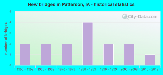
- New bridges - historical statistics
- 21950-1959
- 21960-1969
- 21970-1979
- 41980-1989
- 21990-1999
- 22000-2009
- 12010-2019
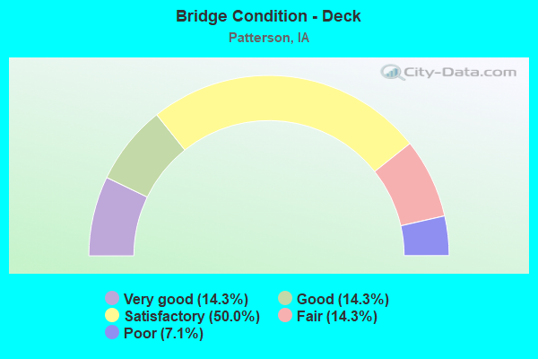
- Bridge Condition - Deck
- 14.3%Very good
- 14.3%Good
- 50.0%Satisfactory
- 14.3%Fair
- 7.1%Poor
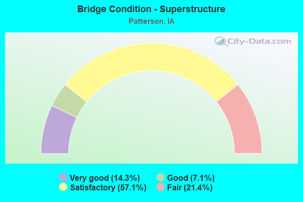
- Bridge Condition - Superstructure
- 14.3%Very good
- 7.1%Good
- 57.1%Satisfactory
- 21.4%Fair
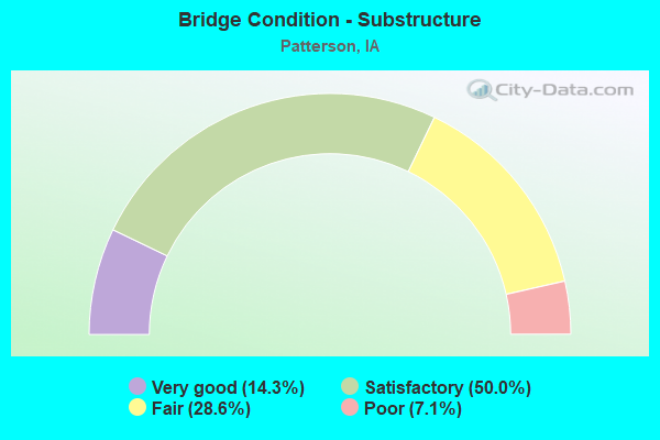
- Bridge Condition - Substructure
- 14.3%Very good
- 50.0%Satisfactory
- 28.6%Fair
- 7.1%Poor
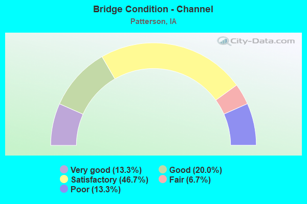
- Bridge Condition - Channel
- 13.3%Very good
- 20.0%Good
- 46.7%Satisfactory
- 6.7%Fair
- 13.3%Poor
Find on map >> Show street view
Structure Number: 2029, Location: 078051004 (Lat: 41.580931, Lng: -91.415644), Route carried "on" structure: County highway , Year Built: 1970, Status: Posted for load, Structure Length: 1.01m (3.31ft), Average Daily Traffic: 50 (year 2018), Average Future Daily Traffic: 50 (year 2041), Design Load: HS 20, Features Intersected: STREAM, Facility Carried by Structure: VINCENT AVE SE
Minimum Vertical Clearance: 30+ m (98+ ft), Kilometerpoint: 1.308, Lanes on structure: 2, Owner: County Highway Agency, Approaching Roadway Width: 9.8m (32.2ft), Skew: 3 degrees, Material/Design: Concrete, Design/Construction: Stringer/Multi-beam, Number Of Spans In Main Unit: 1, Length of Maximum Span: 10.1m (33.1ft), Curb-To-Curb Width: 7.9m (25.9ft), Out-to-Out Width: 8.5m (27.9ft)
Condition: Deck: Satisfactory, Superstructure: Satisfactory, Substructure: Satisfactory, Channel: Satisfactory, Operating Rating: 24.5 metric tons, Method Used To Determine Operating Rating: Allowable Stress (AS), Inventory Rating: 14.5 metric tons, Method Used To Determine Inventory Rating: Allowable Stress (AS), Structural Evaluation: Meets minimum limits, Deck Geometry: Equal to present minimum criteria, Waterway Adequacy: Better than present minimum criteria, Approach Roadway Alignment: Equal to present desirable criteria, Bridge Posting: Required (Relationship of Operating Rating to Maximum Legal Load: 0.1 - 9.9% below), Length Of Structure Improvement: 5.00m (16.40ft), Designated Inspection Frequency: Every 24 months, Inspection Date: April 2021, Bridge Improvement Cost: $85,000, Roadway Improvement Cost: $50,000, Deck Structure Type: Concrete Cast-file-Place, Wearing Surface/Protective System: Wearing Surface: Monolithic Concrete
Find on map >> Show street view
Structure Number: 232861, Location: 075261904 (Lat: 41.286928, Lng: -93.889728), Route carried "on" structure: County highway , Year Built: 1989, Status: Open, Structure Length: 3.54m (11.61ft), Average Daily Traffic: 50 (year 2016), Average Future Daily Traffic: 50 (year 2039), Design Load: HS 20, Features Intersected: JONES CREEK, Facility Carried by Structure: LOCAL RD
Minimum Vertical Clearance: 30+ m (98+ ft), Kilometerpoint: 10.112, Lanes on structure: 2, Owner: County Highway Agency, Approaching Roadway Width: 8.5m (27.9ft), Material/Design: Concrete continuous, Design/Construction: Slab, Number Of Spans In Main Unit: 3, Length of Maximum Span: 13.4m (44.0ft), Curb-To-Curb Width: 7.5m (24.6ft), Out-to-Out Width: 8.3m (27.2ft)
Condition: Deck: Good, Superstructure: Good, Substructure: Satisfactory, Channel: Satisfactory, Operating Rating: 62.9 metric tons, Method Used To Determine Operating Rating: Allowable Stress (AS), Inventory Rating: 38.5 metric tons, Method Used To Determine Inventory Rating: Allowable Stress (AS), Structural Evaluation: Equal to present minimum criteria, Deck Geometry: Equal to present minimum criteria, Waterway Adequacy: Better than present minimum criteria, Approach Roadway Alignment: Equal to present minimum criteria, Length Of Structure Improvement: 11.60m (38.06ft), Designated Inspection Frequency: Every 48 months, Inspection Date: August 2019, Bridge Improvement Cost: $15,000, Roadway Improvement Cost: $2,000, Deck Structure Type: Concrete Cast-file-Place, Wearing Surface/Protective System: Wearing Surface: Monolithic Concrete
Find on map >> Show street view
Structure Number: 233041, Location: 075270103 (Lat: 41.329917, Lng: -93.902756), Route carried "on" structure: County highway , Year Built: 1994, Status: Open, Structure Length: 0.91m (2.99ft), Average Daily Traffic: 50 (year 2016), Average Future Daily Traffic: 50 (year 2041), Design Load: H 20, Features Intersected: DRAINAGE, Facility Carried by Structure: LOCAL RD
Minimum Vertical Clearance: 30+ m (98+ ft), Kilometerpoint: 4.661, Lanes on structure: 2, Owner: County Highway Agency, Approaching Roadway Width: 7.3m (24.0ft), Skew: 4 degrees, Material/Design: Steel, Design/Construction: Stringer/Multi-beam, Number Of Spans In Main Unit: 1, Length of Maximum Span: 8.5m (27.9ft), Curb-To-Curb Width: 7.3m (24.0ft), Out-to-Out Width: 7.6m (24.9ft)
Condition: Deck: Satisfactory, Superstructure: Satisfactory, Substructure: Satisfactory, Channel: Satisfactory, Operating Rating: 31.9 metric tons, Method Used To Determine Operating Rating: Allowable Stress (AS), Inventory Rating: 26.6 metric tons, Method Used To Determine Inventory Rating: Allowable Stress (AS), Structural Evaluation: Equal to present minimum criteria, Deck Geometry: Equal to present minimum criteria, Waterway Adequacy: Equal to present minimum criteria, Approach Roadway Alignment: Better than present minimum criteria, Length Of Structure Improvement: 3.00m (9.84ft), Designated Inspection Frequency: Every 24 months, Inspection Date: August 2021, Bridge Improvement Cost: $15,000, Roadway Improvement Cost: $2,000, Deck Structure Type: Wood or Timber, Wearing Surface/Protective System: Wearing Surface: Gravel
Find on map >> Show street view
Structure Number: 233591, Location: 076260404 (Lat: 41.405433, Lng: -93.859233), Route carried "on" structure: County highway , Year Built: 2015, Status: Open, Structure Length: 0.67m (2.20ft), Average Daily Traffic: 45 (year 2016), Average Future Daily Traffic: 45 (year 2041), Design Load: HS 20, Features Intersected: DRAINAGE, Facility Carried by Structure: UPLAND TRAIL
Minimum Vertical Clearance: 30+ m (98+ ft), Kilometerpoint: 4.834, Lanes on structure: 2, Owner: County Highway Agency, Approaching Roadway Width: 6.7m (22.0ft), Material/Design: Steel, Design/Construction: Culvert, Number Of Spans In Main Unit: 4, Length of Maximum Span: 1.2m (3.9ft)
Condition: Channel: Very good, Culverts: Very good, Operating Rating: 44.1 metric tons, Method Used To Determine Operating Rating: Assigned rating based on Load Factor Design (LFD) reported in metric tons, Inventory Rating: 32.7 metric tons, Method Used To Determine Inventory Rating: Assigned rating based on Load Factor Design (LFD) reported in metric tons, Structural Evaluation: Equal to present desirable criteria, Waterway Adequacy: Equal to present desirable criteria, Approach Roadway Alignment: Better than present minimum criteria, Designated Inspection Frequency: Every 48 months, Inspection Date: August 2021
Find on map >> Show street view
Structure Number: 233601, Location: 076260804 (Lat: 41.388883, Lng: -93.885456), Route carried "on" structure: County highway , Year Built: 1984, Status: Open, Structure Length: 3.14m (10.30ft), Average Daily Traffic: 60 (year 2016), Average Future Daily Traffic: 60 (year 2041), Design Load: H 20, Features Intersected: CEDAR CREEK, Facility Carried by Structure: FM
Minimum Vertical Clearance: 30+ m (98+ ft), Kilometerpoint: 3.236, Lanes on structure: 2, Owner: County Highway Agency, Approaching Roadway Width: 8.5m (27.9ft), Material/Design: Concrete continuous, Design/Construction: Slab, Number Of Spans In Main Unit: 3, Length of Maximum Span: 11.9m (39.0ft), Curb-To-Curb Width: 7.3m (24.0ft), Out-to-Out Width: 8.3m (27.2ft)
Condition: Deck: Satisfactory, Superstructure: Satisfactory, Substructure: Fair, Channel: Poor, Operating Rating: 49.6 metric tons, Method Used To Determine Operating Rating: Allowable Stress (AS), Inventory Rating: 30.8 metric tons, Method Used To Determine Inventory Rating: Allowable Stress (AS), Structural Evaluation: Somewhat better than minimum adequacy, Deck Geometry: Equal to present minimum criteria, Waterway Adequacy: Equal to present minimum criteria, Approach Roadway Alignment: Equal to present minimum criteria, Length Of Structure Improvement: 10.30m (33.79ft), Designated Inspection Frequency: Every 24 months, Inspection Date: August 2021, Bridge Improvement Cost: $15,000, Roadway Improvement Cost: $2,000, Deck Structure Type: Concrete Cast-file-Place, Wearing Surface/Protective System: Wearing Surface: Monolithic Concrete
Find on map >> Show street view
Structure Number: 233621, Location: 076260904 (Lat: 41.401772, Lng: -93.861250), Route carried "on" structure: County highway , Year Built: 2008, Status: Open, Structure Length: 3.75m (12.30ft), Average Daily Traffic: 45 (year 2016), Average Future Daily Traffic: 45 (year 2039), Design Load: HS 20, Features Intersected: NORTH RIVER, Facility Carried by Structure: LOCAL RD
Minimum Vertical Clearance: 30+ m (98+ ft), Kilometerpoint: 4.345, Lanes on structure: 2, Owner: County Highway Agency, Approaching Roadway Width: 7.9m (25.9ft), Skew: 1 degrees, Material/Design: Prestressed concrete, Design/Construction: Tee Beam, Number Of Spans In Main Unit: 3, Length of Maximum Span: 15.5m (50.9ft), Curb-To-Curb Width: 7.3m (24.0ft), Out-to-Out Width: 7.3m (24.0ft)
Condition: Deck: Very good, Superstructure: Very good, Substructure: Very good, Channel: Very good, Operating Rating: 60.8 metric tons, Method Used To Determine Operating Rating: Load Factor (LF), Inventory Rating: 33.9 metric tons, Method Used To Determine Inventory Rating: Load Factor (LF), Structural Evaluation: Equal to present desirable criteria, Deck Geometry: Equal to present minimum criteria, Waterway Adequacy: Better than present minimum criteria, Approach Roadway Alignment: Somewhat better than minimum adequacy, Length Of Structure Improvement: 20.00m (65.62ft), Designated Inspection Frequency: Every 48 months, Inspection Date: August 2019, Bridge Improvement Cost: $15,000, Roadway Improvement Cost: $2,000, Deck Structure Type: Concrete Precast Panels, Wearing Surface/Protective System: Wearing Surface: Gravel
Find on map >> Show street view
Structure Number: 233631, Location: 076260908 (Lat: 41.393428, Lng: -93.859683), Route carried "on" structure: County highway , Year Built: 1958, Year Reconstructed: 1979, Status: Posted for load, Structure Length: 1.59m (5.22ft), Average Daily Traffic: 35 (year 2016), Average Future Daily Traffic: 35 (year 2041), Features Intersected: CEDAR CREEK, Facility Carried by Structure: LOCAL
Minimum Vertical Clearance: 30+ m (98+ ft), Kilometerpoint: 3.288, Lanes on structure: 2, Owner: County Highway Agency, Approaching Roadway Width: 7.9m (25.9ft), Material/Design: Steel, Design/Construction: Stringer/Multi-beam, Number Of Spans In Main Unit: 1, Length of Maximum Span: 15.2m (49.9ft), Curb-To-Curb Width: 7.3m (24.0ft), Out-to-Out Width: 7.6m (24.9ft)
Condition: Deck: Satisfactory, Superstructure: Fair, Substructure: Fair, Channel: Satisfactory, Operating Rating: 25.9 metric tons, Method Used To Determine Operating Rating: Load Factor (LF), Inventory Rating: 15.5 metric tons, Method Used To Determine Inventory Rating: Load Factor (LF), Structural Evaluation: Meets minimum limits, Deck Geometry: Equal to present minimum criteria, Waterway Adequacy: Equal to present minimum criteria, Approach Roadway Alignment: Meets minimum limits, Bridge Posting: Required (Relationship of Operating Rating to Maximum Legal Load: 20.0 - 29.9% below), Length Of Structure Improvement: 7.50m (24.61ft), Designated Inspection Frequency: Every 24 months, Inspection Date: August 2021, Bridge Improvement Cost: $250,000, Roadway Improvement Cost: $50,000, Deck Structure Type: Wood or Timber, Wearing Surface/Protective System: Wearing Surface: Gravel
Find on map >> Show street view
Structure Number: 233681, Location: 076261703 (Lat: 41.378467, Lng: -93.875694), Route carried "on" structure: County highway , Year Built: 1978, Status: Posted for load, Structure Length: 1.31m (4.30ft), Average Daily Traffic: 20 (year 2016), Average Future Daily Traffic: 20 (year 2041), Design Load: H 15, Features Intersected: DRAINAGE, Facility Carried by Structure: LOCAL RD
Minimum Vertical Clearance: 30+ m (98+ ft), Kilometerpoint: 0.816, Lanes on structure: 2, Owner: County Highway Agency, Approaching Roadway Width: 7.9m (25.9ft), Skew: 3 degrees, Material/Design: Steel, Design/Construction: Stringer/Multi-beam, Number Of Spans In Main Unit: 1, Length of Maximum Span: 12.5m (41.0ft), Curb-To-Curb Width: 7.0m (23.0ft), Out-to-Out Width: 7.3m (24.0ft)
Condition: Deck: Satisfactory, Superstructure: Satisfactory, Substructure: Satisfactory, Channel: Satisfactory, Operating Rating: 15.0 metric tons, Method Used To Determine Operating Rating: Allowable Stress (AS), Inventory Rating: 12.4 metric tons, Method Used To Determine Inventory Rating: Allowable Stress (AS), Structural Evaluation: Meets minimum limits, Deck Geometry: Somewhat better than minimum adequacy, Waterway Adequacy: Better than present minimum criteria, Approach Roadway Alignment: Somewhat better than minimum adequacy, Bridge Posting: Required (Relationship of Operating Rating to Maximum Legal Load: 20.0 - 29.9% below), Length Of Structure Improvement: 4.30m (14.11ft), Designated Inspection Frequency: Every 24 months, Inspection Date: August 2021, Bridge Improvement Cost: $20,000, Roadway Improvement Cost: $5,000, Deck Structure Type: Wood or Timber, Wearing Surface/Protective System: Wearing Surface: Gravel
Find on map >> Show street view
Structure Number: 23374, Location: 076262908 (Lat: 41.346722, Lng: -93.880217), Route carried "on" structure: County highway , Year Built: 1958, Status: Posted for load, Structure Length: 7.68m (25.20ft), Average Daily Traffic: 300 (year 2016), Truck Traffic: 12%, Average Future Daily Traffic: 300 (year 2041), Design Load: H 15, Features Intersected: MIDDLE RIVER, Facility Carried by Structure: FM
Minimum Vertical Clearance: 30+ m (98+ ft), Kilometerpoint: 0.005, Lanes on structure: 2, Owner: County Highway Agency, Approaching Roadway Width: 8.5m (27.9ft), Material/Design: Concrete continuous, Design/Construction: Girder and Floorbeam System, Number Of Spans In Main Unit: 3, Length of Maximum Span: 30.5m (100.1ft), Curb-To-Curb Width: 6.2m (20.3ft), Out-to-Out Width: 6.9m (22.6ft)
Condition: Deck: Poor, Superstructure: Fair, Substructure: Fair, Channel: Poor, Operating Rating: 30.7 metric tons, Method Used To Determine Operating Rating: Allowable Stress (AS), Structural Evaluation: High priority of replacement, Deck Geometry: Meets minimum limits, Waterway Adequacy: Equal to present minimum criteria, Approach Roadway Alignment: Equal to present minimum criteria, Bridge Posting: Required (Relationship of Operating Rating to Maximum Legal Load: 0.1 - 9.9% below), Length Of Structure Improvement: 25.20m (82.68ft), Designated Inspection Frequency: Every 24 months, Inspection Date: August 2021, Bridge Improvement Cost: $75,000, Roadway Improvement Cost: $5,000, Deck Structure Type: Concrete Cast-file-Place, Wearing Surface/Protective System: Wearing Surface: Monolithic Concrete
Find on map >> Show street view
Structure Number: 23395, Location: 076272304 (Lat: 41.359406, Lng: -93.921406), Route carried "on" structure: County highway , Year Built: 1962, Status: Open, Structure Length: 3.87m (12.70ft), Average Daily Traffic: 90 (year 2016), Average Future Daily Traffic: 90 (year 2041), Design Load: H 15, Features Intersected: CEDAR CREEK, Facility Carried by Structure: FM
Minimum Vertical Clearance: 30+ m (98+ ft), Kilometerpoint: 3.714, Lanes on structure: 2, Owner: County Highway Agency, Approaching Roadway Width: 8.2m (26.9ft), Material/Design: Concrete continuous, Design/Construction: Slab, Number Of Spans In Main Unit: 3, Length of Maximum Span: 15.2m (49.9ft), Curb-To-Curb Width: 7.4m (24.3ft), Out-to-Out Width: 8.0m (26.2ft)
Condition: Deck: Fair, Superstructure: Fair, Substructure: Satisfactory, Channel: Fair, Operating Rating: 37.2 metric tons, Method Used To Determine Operating Rating: Load Factor (LF), Inventory Rating: 22.3 metric tons, Method Used To Determine Inventory Rating: Load Factor (LF), Structural Evaluation: Somewhat better than minimum adequacy, Deck Geometry: Equal to present minimum criteria, Waterway Adequacy: Better than present minimum criteria, Approach Roadway Alignment: Meets minimum limits, Length Of Structure Improvement: 12.70m (41.67ft), Designated Inspection Frequency: Every 24 months, Inspection Date: August 2021, Bridge Improvement Cost: $75,000, Roadway Improvement Cost: $5,000, Deck Structure Type: Concrete Cast-file-Place, Wearing Surface/Protective System: Wearing Surface: Monolithic Concrete
Find on map >> Show street view
Structure Number: 233961, Location: 076272602 (Lat: 41.358375, Lng: -93.936192), Route carried "on" structure: County highway , Year Built: 2002, Status: Open, Structure Length: 4.33m (14.21ft), Average Daily Traffic: 70 (year 2016), Average Future Daily Traffic: 70 (year 2039), Design Load: HS 20, Features Intersected: CEDAR CREEK, Facility Carried by Structure: LOCAL RD
Minimum Vertical Clearance: 30+ m (98+ ft), Kilometerpoint: 1.139, Lanes on structure: 2, Owner: County Highway Agency, Approaching Roadway Width: 8.5m (27.9ft), Material/Design: Prestressed concrete, Design/Construction: Stringer/Multi-beam, Number Of Spans In Main Unit: 3, Length of Maximum Span: 15.9m (52.2ft), Curb-To-Curb Width: 7.5m (24.6ft), Out-to-Out Width: 8.3m (27.2ft)
Condition: Deck: Very good, Superstructure: Very good, Substructure: Very good, Channel: Good, Operating Rating: 66.6 metric tons, Method Used To Determine Operating Rating: Load Factor (LF), Inventory Rating: 37.2 metric tons, Method Used To Determine Inventory Rating: Load Factor (LF), Structural Evaluation: Equal to present desirable criteria, Deck Geometry: Equal to present minimum criteria, Waterway Adequacy: Better than present minimum criteria, Approach Roadway Alignment: Better than present minimum criteria, Length Of Structure Improvement: 14.20m (46.59ft), Designated Inspection Frequency: Every 48 months, Inspection Date: August 2019, Bridge Improvement Cost: $15,000, Roadway Improvement Cost: $2,000, Deck Structure Type: Concrete Cast-file-Place, Wearing Surface/Protective System: Wearing Surface: Monolithic Concrete
Find on map >> Show street view
Structure Number: 233971, Location: 076273505 (Lat: 41.333542, Lng: -93.930650), Route carried "on" structure: County highway , Year Built: 1996, Status: Open, Structure Length: 1.10m (3.61ft), Average Daily Traffic: 30 (year 2016), Average Future Daily Traffic: 30 (year 2041), Design Load: H 20, Features Intersected: DRAINAGE, Facility Carried by Structure: LOCAL
Minimum Vertical Clearance: 30+ m (98+ ft), Kilometerpoint: 3.048, Lanes on structure: 2, Owner: County Highway Agency, Approaching Roadway Width: 6.1m (20.0ft), Skew: 3 degrees, Material/Design: Steel, Design/Construction: Stringer/Multi-beam, Number Of Spans In Main Unit: 1, Length of Maximum Span: 11.0m (36.1ft), Curb-To-Curb Width: 7.3m (24.0ft), Out-to-Out Width: 7.4m (24.3ft)
Condition: Deck: Good, Superstructure: Satisfactory, Substructure: Satisfactory, Channel: Satisfactory, Operating Rating: 31.7 metric tons, Method Used To Determine Operating Rating: Allowable Stress (AS), Inventory Rating: 26.4 metric tons, Method Used To Determine Inventory Rating: Allowable Stress (AS), Structural Evaluation: Equal to present minimum criteria, Deck Geometry: Equal to present minimum criteria, Waterway Adequacy: Equal to present minimum criteria, Approach Roadway Alignment: Better than present minimum criteria, Length Of Structure Improvement: 3.60m (11.81ft), Designated Inspection Frequency: Every 24 months, Inspection Date: August 2021, Bridge Improvement Cost: $15,000, Roadway Improvement Cost: $2,000, Deck Structure Type: Wood or Timber, Wearing Surface/Protective System: Wearing Surface: Gravel
Find on map >> Show street view
Structure Number: 23399, Location: 076273605 (Lat: 41.338053, Lng: -93.911675), Route carried "on" structure: County highway , Year Built: 1960, Status: Open, Structure Length: 5.55m (18.21ft), Average Daily Traffic: 70 (year 2016), Average Future Daily Traffic: 70 (year 2041), Design Load: H 15, Features Intersected: MIDDLE RIVER, Facility Carried by Structure: LOCAL RD
Minimum Vertical Clearance: 30+ m (98+ ft), Kilometerpoint: 3.571, Lanes on structure: 2, Owner: County Highway Agency, Approaching Roadway Width: 7.9m (25.9ft), Material/Design: Prestressed concrete, Design/Construction: Stringer/Multi-beam, Number Of Spans In Main Unit: 3, Length of Maximum Span: 21.0m (68.9ft), Curb-To-Curb Width: 6.2m (20.3ft), Out-to-Out Width: 6.7m (22.0ft)
Condition: Deck: Fair, Superstructure: Satisfactory, Substructure: Satisfactory, Channel: Good, Operating Rating: 39.5 metric tons, Method Used To Determine Operating Rating: Allowable Stress (AS), Inventory Rating: 18.1 metric tons, Method Used To Determine Inventory Rating: Allowable Stress (AS), Structural Evaluation: Somewhat better than minimum adequacy, Deck Geometry: Somewhat better than minimum adequacy, Waterway Adequacy: Better than present minimum criteria, Approach Roadway Alignment: Meets minimum limits, Length Of Structure Improvement: 18.20m (59.71ft), Designated Inspection Frequency: Every 24 months, Inspection Date: August 2021, Bridge Improvement Cost: $75,000, Roadway Improvement Cost: $5,000, Deck Structure Type: Concrete Cast-file-Place, Wearing Surface/Protective System: Wearing Surface: Monolithic Concrete
Find on map >> Show street view
Structure Number: 234011, Location: 076273611 (Lat: 41.337122, Lng: -93.899153), Route carried "on" structure: County highway , Year Built: 1982, Status: Posted for load, Structure Length: 1.28m (4.20ft), Average Daily Traffic: 70 (year 2016), Average Future Daily Traffic: 70 (year 2041), Features Intersected: SMALL STREAM, Facility Carried by Structure: LOCAL
Minimum Vertical Clearance: 30+ m (98+ ft), Kilometerpoint: 2.515, Lanes on structure: 2, Owner: County Highway Agency, Approaching Roadway Width: 7.9m (25.9ft), Material/Design: Steel, Design/Construction: Stringer/Multi-beam, Number Of Spans In Main Unit: 1, Length of Maximum Span: 12.2m (40.0ft), Curb-To-Curb Width: 7.0m (23.0ft), Out-to-Out Width: 7.3m (24.0ft)
Condition: Deck: Satisfactory, Superstructure: Satisfactory, Substructure: Poor, Channel: Satisfactory, Operating Rating: 31.4 metric tons, Method Used To Determine Operating Rating: Allowable Stress (AS), Inventory Rating: 21.1 metric tons, Method Used To Determine Inventory Rating: Allowable Stress (AS), Structural Evaluation: Meets minimum limits, Deck Geometry: Somewhat better than minimum adequacy, Waterway Adequacy: Better than present minimum criteria, Approach Roadway Alignment: Equal to present minimum criteria, Bridge Posting: Required (Relationship of Operating Rating to Maximum Legal Load: 10.0 - 19.9% below), Length Of Structure Improvement: 4.20m (13.78ft), Designated Inspection Frequency: Every 24 months, Inspection Date: August 2021, Bridge Improvement Cost: $50,000, Roadway Improvement Cost: $5,000, Deck Structure Type: Wood or Timber, Wearing Surface/Protective System: Wearing Surface: Gravel
Find on map >> Show street view
Structure Number: 36321, Location: 076273603 (Lat: 41.340778, Lng: -93.899317), Route carried "on" structure: County highway , Year Built: 1989, Status: Open, Structure Length: 0.76m (2.49ft), Average Daily Traffic: 10 (year 2016), Average Future Daily Traffic: 10 (year 2041), Design Load: H 15, Features Intersected: SMALL, Facility Carried by Structure: LOCAL
Minimum Vertical Clearance: 30+ m (98+ ft), Kilometerpoint: 0.385, Lanes on structure: 2, Owner: County Highway Agency, Approaching Roadway Width: 7.3m (24.0ft), Material/Design: Steel, Design/Construction: Stringer/Multi-beam, Number Of Spans In Main Unit: 1, Length of Maximum Span: 7.3m (24.0ft), Curb-To-Curb Width: 7.3m (24.0ft), Out-to-Out Width: 7.3m (24.0ft)
Condition: Deck: Satisfactory, Superstructure: Satisfactory, Substructure: Fair, Channel: Good, Operating Rating: 35.1 metric tons, Method Used To Determine Operating Rating: Allowable Stress (AS), Inventory Rating: 29.2 metric tons, Method Used To Determine Inventory Rating: Allowable Stress (AS), Structural Evaluation: Somewhat better than minimum adequacy, Deck Geometry: Equal to present minimum criteria, Waterway Adequacy: Better than present minimum criteria, Approach Roadway Alignment: Somewhat better than minimum adequacy, Length Of Structure Improvement: 2.50m (8.20ft), Designated Inspection Frequency: Every 24 months, Inspection Date: August 2021, Bridge Improvement Cost: $15,000, Roadway Improvement Cost: $2,000, Deck Structure Type: Wood or Timber, Wearing Surface/Protective System: Wearing Surface: Gravel