Bridge Statistics for Pegram, Tennessee (TN)
Condition, Traffic, Stress, Structural Evaluation, Project Costs
- National Bridge Inventory (NBI) Statistics
- 14Number of bridges
- 276ft / 84.0mTotal length
- $15,340,000Total costs
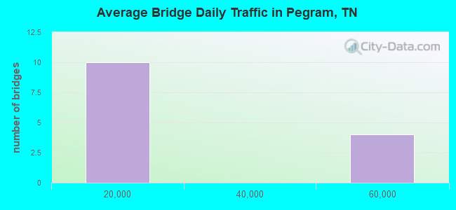
- 227,358Total average daily traffic
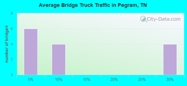
- 52,536Total average daily truck traffic
- National Bridge Inventory (NBI) Registered Bridges for Pegram
- No street view available for this location
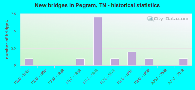
- New bridges - historical statistics
- 11920-1929
- 11950-1959
- 71960-1969
- 11970-1979
- 21980-1989
- 11990-1999
- 12010-2019

- Reconstructed bridges - Historical Statistics
- 11940-1949
- 01950-1959
- 01960-1969
- 01970-1979
- 21980-1989
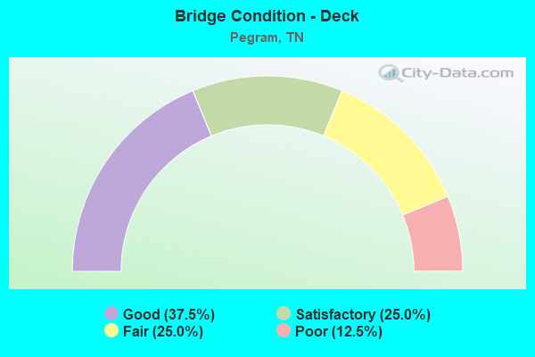
- Bridge Condition - Deck
- 37.5%Good
- 25.0%Satisfactory
- 25.0%Fair
- 12.5%Poor
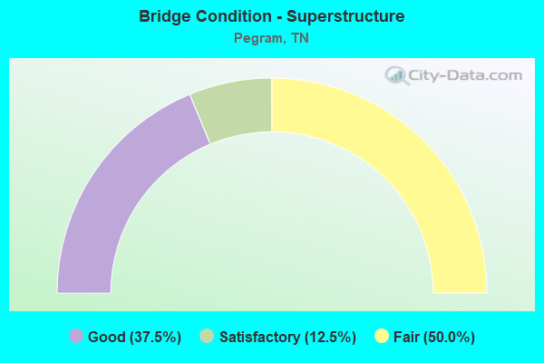
- Bridge Condition - Superstructure
- 37.5%Good
- 12.5%Satisfactory
- 50.0%Fair
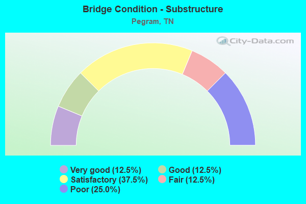
- Bridge Condition - Substructure
- 12.5%Very good
- 12.5%Good
- 37.5%Satisfactory
- 12.5%Fair
- 25.0%Poor
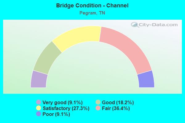
- Bridge Condition - Channel
- 9.1%Very good
- 18.2%Good
- 27.3%Satisfactory
- 36.4%Fair
- 9.1%Poor
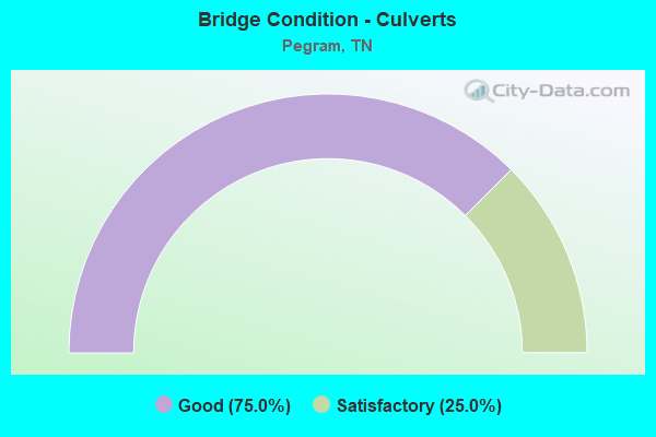
- Bridge Condition - Culverts
- 75.0%Good
- 25.0%Satisfactory
Find on map >> Show street view
Structure Number: 11019330005, Location: 0.1 M. N. SR-1. (Lat: 36.124667, Lng: -87.098050), Route carried "on" structure: County highway 1933, Year Built: 1995, Status: Open, Structure Length: 1.01m (3.31ft), Average Daily Traffic: 761 (year 2020), Truck Traffic: 3%, Average Future Daily Traffic: 1,392 (year 2040), Design Load: HS 20, Features Intersected: DOG CREEK
Minimum Vertical Clearance: 30+ m (98+ ft), Kilometerpoint: 18.733, Lanes on structure: 2, Owner: County Highway Agency, Approaching Roadway Width: 10.4m (34.1ft), Skew: 1 degrees, Material/Design: Concrete continuous, Design/Construction: Culvert, Number Of Spans In Main Unit: 2, Length of Maximum Span: 4.6m (15.1ft)
Condition: Channel: Good, Culverts: Good, Operating Rating: 54.0 metric tons, Method Used To Determine Operating Rating: Field evaluation and documented engineering judgment, Inventory Rating: 32.4 metric tons, Method Used To Determine Inventory Rating: Field evaluation and documented engineering judgment, Structural Evaluation: Better than present minimum criteria, Waterway Adequacy: Equal to present minimum criteria, Approach Roadway Alignment: Equal to present desirable criteria, Designated Inspection Frequency: Every 24 months, Inspection Date: September 2020
Find on map >> Show street view
Structure Number: 11019330009, Location: 1 M. N. SR-1. (Lat: 36.140550, Lng: -87.095183), Route carried "on" structure: County highway 1933, Year Built: 1978, Status: Open, Structure Length: 2.74m (8.99ft), Average Daily Traffic: 761 (year 2020), Truck Traffic: 3%, Average Future Daily Traffic: 1,392 (year 2040), Design Load: HS 20, Features Intersected: MOUND CREEK
Minimum Vertical Clearance: 30+ m (98+ ft), Kilometerpoint: 16.576, Lanes on structure: 2, Owner: County Highway Agency, Approaching Roadway Width: 7.0m (23.0ft), Skew: 2 degrees, Material/Design: Prestressed concrete continuous, Design/Construction: Stringer/Multi-beam, Number Of Spans In Main Unit: 2, Length of Maximum Span: 12.8m (42.0ft), Curb-To-Curb Width: 7.9m (25.9ft), Out-to-Out Width: 8.6m (28.2ft)
Condition: Deck: Good, Superstructure: Good, Substructure: Fair, Channel: Satisfactory, Operating Rating: 44.1 metric tons, Method Used To Determine Operating Rating: Assigned rating based on Load Factor Design (LFD) reported in metric tons, Inventory Rating: 32.4 metric tons, Method Used To Determine Inventory Rating: Assigned rating based on Load Factor Design (LFD) reported in metric tons, Structural Evaluation: Somewhat better than minimum adequacy, Deck Geometry: Somewhat better than minimum adequacy, Waterway Adequacy: Better than present minimum criteria, Approach Roadway Alignment: Equal to present minimum criteria, Designated Inspection Frequency: Every 24 months, Inspection Date: September 2020, Deck Structure Type: Concrete Cast-file-Place, Wearing Surface/Protective System: Wearing Surface: Bituminous
Find on map >> Show street view
Structure Number: 110A3390001, Location: 1.5 M. NE. SR-1. (Lat: 36.111250, Lng: -87.019783), Route carried "on" structure: County highway 339, Year Built: 1950, Status: Open, Structure Length: 1.10m (3.61ft), Average Daily Traffic: 390 (year 2022), Truck Traffic: 4%, Average Future Daily Traffic: 624 (year 2040), Design Load: H 15, Features Intersected: BRANCH
Minimum Vertical Clearance: 30+ m (98+ ft), Kilometerpoint: 0.315, Lanes on structure: 2, Owner: County Highway Agency, Approaching Roadway Width: 6.1m (20.0ft), Skew: 2 degrees, Material/Design: Concrete continuous, Design/Construction: Culvert, Number Of Spans In Main Unit: 2, Length of Maximum Span: 4.6m (15.1ft), Curb-To-Curb Width: 6.6m (21.7ft), Out-to-Out Width: 7.2m (23.6ft)
Condition: Channel: Satisfactory, Culverts: Good, Operating Rating: 49.5 metric tons, Method Used To Determine Operating Rating: Load Factor (LF), Inventory Rating: 29.7 metric tons, Method Used To Determine Inventory Rating: Load Factor (LF), Structural Evaluation: Better than present minimum criteria, Deck Geometry: Meets minimum limits, Waterway Adequacy: Equal to present minimum criteria, Approach Roadway Alignment: Equal to present minimum criteria, Length Of Structure Improvement: 1.10m (3.61ft), Designated Inspection Frequency: Every 24 months, Inspection Date: September 2020, Bridge Improvement Cost: $75,000, Roadway Improvement Cost: $8,000, Total Project Cost: $113,000 ( Estimate for 2020), Deck Structure Type: Concrete Cast-file-Place, Wearing Surface/Protective System: Wearing Surface: Bituminous
Find on map >> Show street view
Structure Number: 110A3600001, Location: 0.75 M.N. I40 IN PEGRAM (Lat: 36.096033, Lng: -87.054467), Route carried "on" structure: City street 360, Year Built: 1987, Status: Open, Structure Length: 10.70m (35.10ft), Average Daily Traffic: 1,240 (year 2022), Truck Traffic: 4%, Average Future Daily Traffic: 1,984 (year 2041), Design Load: HS 20, Features Intersected: HARPETH RIVER
Minimum Vertical Clearance: 30+ m (98+ ft), Kilometerpoint: 0.504, Lanes on structure: 2, Owner: City or Municipal Highway Agency, Approaching Roadway Width: 6.7m (22.0ft), Material/Design: Prestressed concrete continuous, Design/Construction: Box Beam or Girders - Single/Spread, Number Of Spans In Main Unit: 4, Length of Maximum Span: 26.8m (87.9ft), Curb-To-Curb Width: 6.7m (22.0ft), Out-to-Out Width: 7.3m (24.0ft)
Condition: Deck: Satisfactory, Superstructure: Fair, Substructure: Satisfactory, Channel: Fair, Operating Rating: 32.4 metric tons, Method Used To Determine Operating Rating: Load and Resistance Factor Rating (LRFR) rating reported by rating factor(RF) method using HL-93 loadings, Inventory Rating: 24.9 metric tons, Method Used To Determine Inventory Rating: Load and Resistance Factor Rating (LRFR) rating reported by rating factor(RF) method using HL-93 loadings, Structural Evaluation: Somewhat better than minimum adequacy, Deck Geometry: High priority of corrective action, Waterway Adequacy: Somewhat better than minimum adequacy, Approach Roadway Alignment: Equal to present minimum criteria, Length Of Structure Improvement: 10.70m (35.10ft), Designated Inspection Frequency: Every 24 months, Underwater Inspection Frequency: Every 60 months, Inspection Date: August 2020, Underwater Inspection Date: July 2018, Bridge Improvement Cost: $982,000, Roadway Improvement Cost: $99,000, Total Project Cost: $1,474,000 ( Estimate for 2021), Deck Structure Type: Concrete Precast Panels, Wearing Surface/Protective System: Wearing Surface: Monolithic Concrete
Find on map >> Show street view
Structure Number: 11I00400007, Location: .4 M E JCT SR249&I40 (Lat: 36.085250, Lng: -87.088700), Route carried "on" structure: Interstate 40, Year Built: 1960, Year Reconstructed: 1988, Status: Open, Structure Length: 18.26m (59.91ft), Average Daily Traffic: 51,305 (year 2020), Truck Traffic: 25%, Average Future Daily Traffic: 82,088 (year 2042), Design Load: HS 20, Features Intersected: HARPETH RIVER
Minimum Vertical Clearance: 30+ m (98+ ft), Kilometerpoint: 6.566, Lanes on structure: 2, Base Highway Network: Yes, Owner: State Highway Agency, Approaching Roadway Width: 11.6m (38.1ft), Skew: 10 degrees, Material/Design: Prestressed concrete, Design/Construction: Stringer/Multi-beam, Number Of Spans In Main Unit: 14, Length of Maximum Span: 14.9m (48.9ft), Curb or Sidewalk Widths: Left: 0.6m (2.0ft), Right: 0.6m (2.0ft), Curb-To-Curb Width: 12.8m (42.0ft), Out-to-Out Width: 13.4m (44.0ft)
Condition: Deck: Poor, Superstructure: Fair, Substructure: Poor, Channel: Poor, Operating Rating: 41.1 metric tons, Method Used To Determine Operating Rating: Load and Resistance Factor Rating (LRFR) rating reported by rating factor(RF) method using HL-93 loadings, Inventory Rating: 31.8 metric tons, Method Used To Determine Inventory Rating: Load and Resistance Factor Rating (LRFR) rating reported by rating factor(RF) method using HL-93 loadings, Structural Evaluation: Meets minimum limits, Deck Geometry: Equal to present desirable criteria, Waterway Adequacy: Somewhat better than minimum adequacy, Approach Roadway Alignment: Equal to present desirable criteria, Length Of Structure Improvement: 18.26m (59.91ft), Designated Inspection Frequency: Every 24 months, Underwater Inspection Frequency: Every 60 months, Inspection Date: August 2020, Underwater Inspection Date: May 2021, Bridge Improvement Cost: $3,956,000, Roadway Improvement Cost: $396,000, Total Project Cost: $5,935,000 ( Estimate for 2022), Deck Structure Type: Concrete Cast-file-Place, Wearing Surface/Protective System: Wearing Surface: Monolithic Concrete
Find on map >> Show street view
Structure Number: 11I00400008, Location: .4 M E JCT SR249&I40 (Lat: 36.085300, Lng: -87.088683), Route carried "on" structure: Interstate 40, Year Built: 1960, Year Reconstructed: 1988, Status: Open, Structure Length: 18.26m (59.91ft), Average Daily Traffic: 51,305 (year 2020), Truck Traffic: 25%, Average Future Daily Traffic: 82,088 (year 2042), Design Load: HS 20, Features Intersected: HARPETH RIVER
Minimum Vertical Clearance: 30+ m (98+ ft), Kilometerpoint: 6.566, Lanes on structure: 2, Base Highway Network: Yes, Owner: State Highway Agency, Approaching Roadway Width: 11.6m (38.1ft), Skew: 10 degrees, Material/Design: Prestressed concrete, Design/Construction: Stringer/Multi-beam, Number Of Spans In Main Unit: 14, Length of Maximum Span: 14.9m (48.9ft), Curb or Sidewalk Widths: Left: 0.6m (2.0ft), Right: 0.6m (2.0ft), Curb-To-Curb Width: 12.8m (42.0ft), Out-to-Out Width: 13.4m (44.0ft)
Condition: Deck: Fair, Superstructure: Fair, Substructure: Poor, Channel: Satisfactory, Operating Rating: 40.2 metric tons, Method Used To Determine Operating Rating: Load and Resistance Factor Rating (LRFR) rating reported by rating factor(RF) method using HL-93 loadings, Inventory Rating: 30.8 metric tons, Method Used To Determine Inventory Rating: Load and Resistance Factor Rating (LRFR) rating reported by rating factor(RF) method using HL-93 loadings, Structural Evaluation: Meets minimum limits, Deck Geometry: Equal to present desirable criteria, Waterway Adequacy: Better than present minimum criteria, Approach Roadway Alignment: Equal to present desirable criteria, Length Of Structure Improvement: 18.26m (59.91ft), Designated Inspection Frequency: Every 24 months, Underwater Inspection Frequency: Every 60 months, Inspection Date: August 2020, Underwater Inspection Date: May 2021, Bridge Improvement Cost: $3,956,000, Roadway Improvement Cost: $396,000, Total Project Cost: $5,935,000 ( Estimate for 2022), Deck Structure Type: Concrete Cast-file-Place, Wearing Surface/Protective System: Wearing Surface: Monolithic Concrete
Find on map >> Show street view
Structure Number: 11I00400009, Location: 2 M.E. DAVIDSON CO. LN. (Lat: 36.088317, Lng: -87.068617), Route carried "on" structure: County highway 363, Year Built: 1960, Status: Open, Structure Length: 6.52m (21.39ft), Average Daily Traffic: 10 (year 2022), Truck Traffic: 2%, Average Future Daily Traffic: 16 (year 2040), Design Load: H 15, Features Intersected: BEECH HILL RD / I40
Minimum Vertical Clearance: 30+ m (98+ ft), Kilometerpoint: 1.561, Lanes on structure: 2, Lanes under structure: 4, Owner: State Highway Agency, Approaching Roadway Width: 6.1m (20.0ft), Material/Design: Steel continuous, Design/Construction: Stringer/Multi-beam, Number Of Spans In Main Unit: 2, Number Of Approach Spans: 2, Length of Maximum Span: 20.1m (65.9ft), Curb-To-Curb Width: 7.3m (24.0ft), Out-to-Out Width: 8.6m (28.2ft)
Condition: Deck: Fair, Superstructure: Satisfactory, Substructure: Satisfactory, Operating Rating: 45.9 metric tons, Method Used To Determine Operating Rating: Load Factor (LF), Inventory Rating: 27.0 metric tons, Method Used To Determine Inventory Rating: Load Factor (LF), Structural Evaluation: Equal to present minimum criteria, Deck Geometry: Equal to present minimum criteria, Underclear: Meets minimum limits, Approach Roadway Alignment: Equal to present minimum criteria, Length Of Structure Improvement: 6.52m (21.39ft), Designated Inspection Frequency: Every 24 months, Inspection Date: August 2020, Bridge Improvement Cost: $875,000, Roadway Improvement Cost: $88,000, Total Project Cost: $1,313,000 ( Estimate for 2020), Deck Structure Type: Concrete Cast-file-Place, Wearing Surface/Protective System: Wearing Surface: Bituminous
Find on map >> Show street view
Structure Number: 11I00400011, Location: 2 M E JCT SR249&I40 (Lat: 36.087750, Lng: -87.066383), Route carried "on" structure: Interstate 40, Year Built: 2016, Status: Open, Structure Length: 19.15m (62.83ft), Average Daily Traffic: 51,305 (year 2020), Truck Traffic: 25%, Average Future Daily Traffic: 100,080 (year 2040), Design Load: HL 93, Features Intersected: HARPETH RIVER
Minimum Vertical Clearance: 30+ m (98+ ft), Kilometerpoint: 9.061, Lanes on structure: 40, Lanes under structure: 2, Base Highway Network: Yes, Owner: State Highway Agency, Approaching Roadway Width: 39.8m (130.6ft), Skew: 34 degrees, Material/Design: Prestressed concrete, Design/Construction: Stringer/Multi-beam, Number Of Spans In Main Unit: 8, Length of Maximum Span: 25.4m (83.3ft), Curb-To-Curb Width: 39.8m (130.6ft), Out-to-Out Width: 40.8m (133.9ft)
Condition: Deck: Good, Superstructure: Good, Substructure: Very good, Channel: Very good, Operating Rating: 42.8 metric tons, Method Used To Determine Operating Rating: Load and Resistance Factor Rating (LRFR) rating reported by rating factor(RF) method using HL-93 loadings, Inventory Rating: 28.5 metric tons, Method Used To Determine Inventory Rating: Load and Resistance Factor Rating (LRFR) rating reported by rating factor(RF) method using HL-93 loadings, Structural Evaluation: Better than present minimum criteria, Deck Geometry: High priority of replacement, Underclear: Superior to present desirable criteria, Waterway Adequacy: Equal to present desirable criteria, Approach Roadway Alignment: Equal to present desirable criteria, Designated Inspection Frequency: Every 24 months, Inspection Date: August 2020, Deck Structure Type: Corrugated Steel, Wearing Surface/Protective System: Wearing Surface: Monolithic Concrete
Find on map >> Show street view
Structure Number: 11S63600005, Location: 5.5 MI. N. OF PEGRAM (Lat: 36.159133, Lng: -87.044250), Route carried "on" structure: State highway 249, Year Built: 1968, Status: Open, Structure Length: 1.40m (4.59ft), Average Daily Traffic: 2,949 (year 2020), Truck Traffic: 5%, Average Future Daily Traffic: 4,576 (year 2040), Design Load: HS 20, Features Intersected: SAMS CREEK
Minimum Vertical Clearance: 30+ m (98+ ft), Kilometerpoint: 11.105, Lanes on structure: 2, Owner: State Highway Agency, Approaching Roadway Width: 8.5m (27.9ft), Skew: 4 degrees, Material/Design: Concrete continuous, Design/Construction: Culvert, Number Of Spans In Main Unit: 3, Length of Maximum Span: 3.0m (9.8ft)
Condition: Channel: Good, Culverts: Good, Operating Rating: 89.1 metric tons, Method Used To Determine Operating Rating: Load Factor (LF), Inventory Rating: 32.4 metric tons, Method Used To Determine Inventory Rating: Load Factor (LF), Structural Evaluation: Better than present minimum criteria, Waterway Adequacy: Equal to present minimum criteria, Approach Roadway Alignment: Equal to present minimum criteria, Designated Inspection Frequency: Every 24 months, Inspection Date: August 2020
Find on map >> Show street view
Structure Number: 11S63600007, Location: 6.5 MI. N. OF PEGRAM (Lat: 36.171783, Lng: -87.047133), Route carried "on" structure: State highway 249, Year Built: 1968, Status: Open, Structure Length: 1.16m (3.81ft), Average Daily Traffic: 2,949 (year 2020), Truck Traffic: 5%, Average Future Daily Traffic: 4,576 (year 2040), Design Load: HS 20, Features Intersected: SAMS CREEK
Minimum Vertical Clearance: 30+ m (98+ ft), Kilometerpoint: 12.666, Lanes on structure: 2, Owner: State Highway Agency, Approaching Roadway Width: 9.1m (29.9ft), Skew: 3 degrees, Material/Design: Concrete continuous, Design/Construction: Culvert, Number Of Spans In Main Unit: 3, Length of Maximum Span: 3.0m (9.8ft)
Condition: Channel: Fair, Culverts: Satisfactory, Operating Rating: 65.7 metric tons, Method Used To Determine Operating Rating: Load Factor (LF), Inventory Rating: 32.4 metric tons, Method Used To Determine Inventory Rating: Load Factor (LF), Structural Evaluation: Equal to present minimum criteria, Waterway Adequacy: Equal to present minimum criteria, Approach Roadway Alignment: Equal to present minimum criteria, Designated Inspection Frequency: Every 24 months, Inspection Date: August 2020
Find on map >> Show street view
Structure Number: 11S63600009, Location: 4.8 MI.S.E. OF SR 49 (Lat: 36.178983, Lng: -87.039567), Route carried "on" structure: State highway 249, Year Built: 1968, Status: Open, Structure Length: 2.87m (9.42ft), Average Daily Traffic: 2,949 (year 2020), Truck Traffic: 5%, Average Future Daily Traffic: 4,718 (year 2041), Design Load: HS 20, Features Intersected: SAMS CREEK
Minimum Vertical Clearance: 30+ m (98+ ft), Kilometerpoint: 13.696, Lanes on structure: 2, Owner: State Highway Agency, Approaching Roadway Width: 9.1m (29.9ft), Skew: 4 degrees, Material/Design: Prestressed concrete, Design/Construction: Stringer/Multi-beam, Number Of Spans In Main Unit: 3, Length of Maximum Span: 9.8m (32.2ft), Curb-To-Curb Width: 7.3m (24.0ft), Out-to-Out Width: 8.7m (28.5ft)
Condition: Deck: Good, Superstructure: Good, Substructure: Good, Channel: Fair, Operating Rating: 34.2 metric tons, Method Used To Determine Operating Rating: Load Factor (LF), Inventory Rating: 20.7 metric tons, Method Used To Determine Inventory Rating: Load Factor (LF), Structural Evaluation: Somewhat better than minimum adequacy, Deck Geometry: High priority of replacement, Waterway Adequacy: Equal to present minimum criteria, Approach Roadway Alignment: Equal to present desirable criteria, Length Of Structure Improvement: 2.87m (9.42ft), Designated Inspection Frequency: Every 24 months, Inspection Date: August 2020, Bridge Improvement Cost: $288,000, Roadway Improvement Cost: $29,000, Total Project Cost: $433,000 ( Estimate for 2021), Deck Structure Type: Concrete Cast-file-Place, Wearing Surface/Protective System: Wearing Surface: Bituminous
Find on map >> Show street view
Structure Number: 11SR0010003, Location: IN PEGRAM - TENNESSEE (Lat: 36.097183, Lng: -87.045867), Route carried "on" structure: US 70, Year Built: 1926, Year Reconstructed: 1953, Status: Open, Structure Length: 0.82m (2.69ft), Average Daily Traffic: 9,289 (year 2020), Truck Traffic: 7%, Average Future Daily Traffic: 17,008 (year 2040), Design Load: H 15, Features Intersected: TURNER CREEK, Facility Carried by Structure: FAP 1
Minimum Vertical Clearance: 30+ m (98+ ft), Kilometerpoint: 14.275, Lanes on structure: 2, Base Highway Network: Yes, Owner: State Highway Agency, Approaching Roadway Width: 9.8m (32.2ft), Material/Design: Concrete, Design/Construction: Tee Beam, Number Of Spans In Main Unit: 1, Length of Maximum Span: 7.3m (24.0ft), Curb-To-Curb Width: 8.5m (27.9ft), Out-to-Out Width: 10.5m (34.4ft)
Condition: Deck: Satisfactory, Superstructure: Fair, Substructure: Satisfactory, Channel: Fair, Operating Rating: 46.8 metric tons, Method Used To Determine Operating Rating: Load Factor (LF), Inventory Rating: 32.4 metric tons, Method Used To Determine Inventory Rating: Load Factor (LF), Structural Evaluation: Somewhat better than minimum adequacy, Deck Geometry: High priority of replacement, Waterway Adequacy: Somewhat better than minimum adequacy, Approach Roadway Alignment: Equal to present desirable criteria, Length Of Structure Improvement: 0.82m (2.69ft), Designated Inspection Frequency: Every 24 months, Inspection Date: August 2020, Bridge Improvement Cost: $91,000, Roadway Improvement Cost: $10,000, Total Project Cost: $137,000 ( Estimate for 2020), Deck Structure Type: Concrete Cast-file-Place, Wearing Surface/Protective System: Wearing Surface: Bituminous
Find on map >> Show street view
Structure Number: 11I00400009, Location: NEAR KINGSTON SPRINGS TN. (Lat: 36.088317, Lng: -87.068617), Route carried "under" structure: Interstate 40, Year Built: 1960, Structure Length: 0. m, Average Daily Traffic: 51,305 (year 2020), Truck Traffic: 25%, Features Intersected: BEECH HILL RD / I40, Facility Carried by Structure: NFA A363
Minimum Vertical Clearance: 4.80m (15.75ft), Kilometerpoint: 8.562, Lanes on structure: 4, Lanes under structure: 2, Material/Design: Steel, Design/Construction: Stringer/Multi-beam, Length of Maximum Span: 20.1m (65.9ft)
Find on map >> Show street view
Structure Number: 11I00400011, Location: WEST OF DAVIDSON CO (Lat: 36.087558, Lng: -87.063011), Route carried "under" structure: County highway 360, Year Built: 1986, Structure Length: 0. m, Average Daily Traffic: 840 (year 2022), Truck Traffic: 4%, Features Intersected: I40, Facility Carried by Structure: I40
Minimum Vertical Clearance: 5.89m (19.32ft), Kilometerpoint: 2.074, Lanes on structure: 2, Lanes under structure: 2, Material/Design: Prestressed concrete continuous, Design/Construction: Stringer/Multi-beam, Length of Maximum Span: 18.3m (60.0ft)