Bridge Statistics for Philadelphia, New York (NY)
Condition, Traffic, Stress, Structural Evaluation, Project Costs
- National Bridge Inventory (NBI) Statistics
- 11Number of bridges
- 82ft / 25.2mTotal length
- $9,916,000Total costs
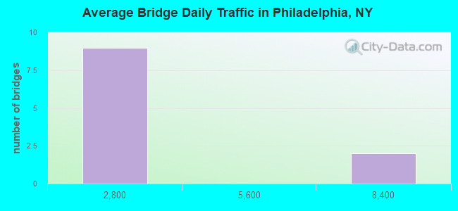
- 18,525Total average daily traffic
- 2,422Total average daily truck traffic
- 19,494Total future (year 2037) average daily traffic
- National Bridge Inventory (NBI) Registered Bridges for Philadelphia
- No street view available for this location
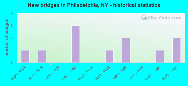
- New bridges - historical statistics
- 11900-1909
- 11910-1919
- 31930-1939
- 11950-1959
- 21960-1969
- 11980-1989
- 21990-1999
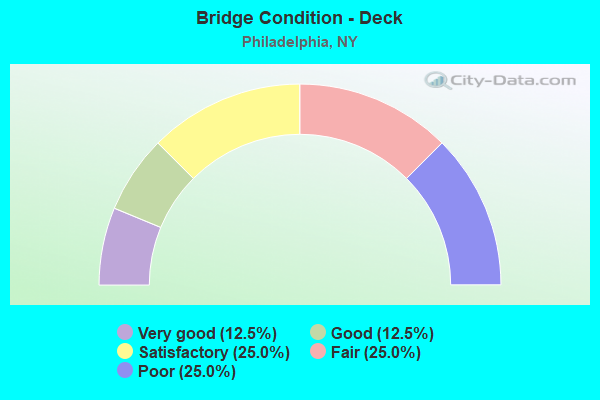
- Bridge Condition - Deck
- 12.5%Very good
- 12.5%Good
- 25.0%Satisfactory
- 25.0%Fair
- 25.0%Poor
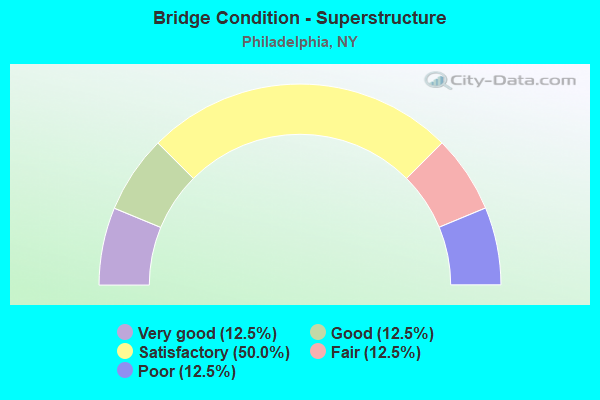
- Bridge Condition - Superstructure
- 12.5%Very good
- 12.5%Good
- 50.0%Satisfactory
- 12.5%Fair
- 12.5%Poor
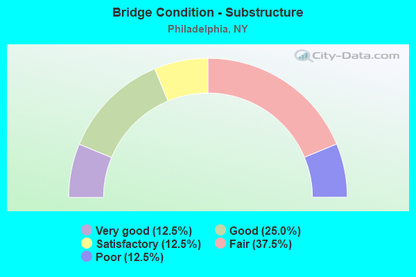
- Bridge Condition - Substructure
- 12.5%Very good
- 25.0%Good
- 12.5%Satisfactory
- 37.5%Fair
- 12.5%Poor
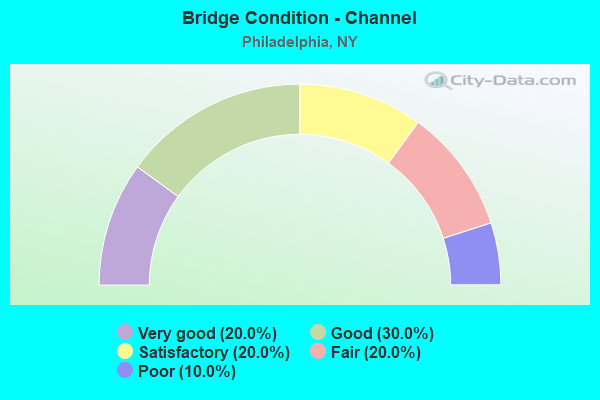
- Bridge Condition - Channel
- 20.0%Very good
- 30.0%Good
- 20.0%Satisfactory
- 20.0%Fair
- 10.0%Poor
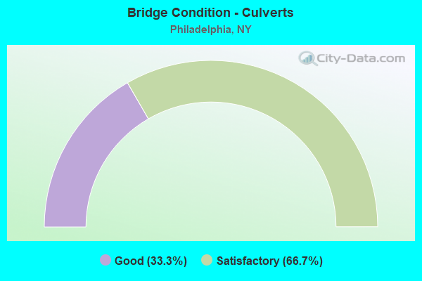
- Bridge Condition - Culverts
- 33.3%Good
- 66.7%Satisfactory
Find on map >> Show street view
Structure Number: 10087, Location: .9 MI S JCT US 11 & SH 26 (Lat: 44.150161, Lng: -75.709014), Route carried "on" structure: US 11, Year Built: 1986, Status: Open, Structure Length: 7.04m (23.10ft), Average Daily Traffic: 7,590 (year 2020), Truck Traffic: 14%, Average Future Daily Traffic: 7,662 (year 2040), Design Load: HS 20, Features Intersected: CSX TRANSPRTATION
Minimum Vertical Clearance: 30+ m (98+ ft), Kilometerpoint: 65.197, Lanes on structure: 2, Base Highway Network: Yes, Owner: State Highway Agency, Approaching Roadway Width: 12.2m (40.0ft), Skew: 1 degrees, Material/Design: Prestressed concrete continuous, Design/Construction: Box Beam or Girders - Multiple, Number Of Spans In Main Unit: 3, Length of Maximum Span: 25.9m (85.0ft), Curb or Sidewalk Widths: Left: 0.0m, Right: 1.5m (4.9ft), Curb-To-Curb Width: 12.2m (40.0ft), Out-to-Out Width: 14.5m (47.6ft)
Condition: Deck: Satisfactory, Superstructure: Satisfactory, Substructure: Satisfactory, Operating Rating: 98.9 metric tons, Method Used To Determine Operating Rating: Load Factor (LF), Inventory Rating: 59.0 metric tons, Method Used To Determine Inventory Rating: Load Factor (LF), Structural Evaluation: Equal to present minimum criteria, Deck Geometry: Somewhat better than minimum adequacy, Underclear: Equal to present minimum criteria, Approach Roadway Alignment: Equal to present desirable criteria, Length Of Structure Improvement: 7.04m (23.10ft), Designated Inspection Frequency: Every 24 months, Inspection Date: June 2020, Bridge Improvement Cost: $1,460,000, Roadway Improvement Cost: $855,000, Total Project Cost: $2,315,000 ( Estimate for 2021), Wearing Surface/Protective System: Wearing Surface: Bituminous, Membrane: Other
Find on map >> Show street view
Structure Number: 100871, Location: JCT RTE 11 + INDIAN R (Lat: 44.156703, Lng: -75.708800), Route carried "on" structure: US 11, Year Built: 1958, Status: Open, Structure Length: 5.39m (17.68ft), Average Daily Traffic: 7,590 (year 2020), Truck Traffic: 14%, Average Future Daily Traffic: 7,662 (year 2040), Design Load: H 20, Features Intersected: INDIAN RIVER
Minimum Vertical Clearance: 30+ m (98+ ft), Kilometerpoint: 65.921, Lanes on structure: 2, Base Highway Network: Yes, Owner: State Highway Agency, Approaching Roadway Width: 11.0m (36.1ft), Skew: 4 degrees, Material/Design: Steel, Design/Construction: Stringer/Multi-beam, Number Of Spans In Main Unit: 3, Length of Maximum Span: 17.0m (55.8ft), Curb or Sidewalk Widths: Left: 1.5m (4.9ft), Right: 1.5m (4.9ft), Curb-To-Curb Width: 11.0m (36.1ft), Out-to-Out Width: 14.6m (47.9ft)
Condition: Deck: Fair, Superstructure: Satisfactory, Substructure: Fair, Channel: Very good, Operating Rating: 64.4 metric tons, Method Used To Determine Operating Rating: Load Factor (LF), Inventory Rating: 38.1 metric tons, Method Used To Determine Inventory Rating: Load Factor (LF), Structural Evaluation: Somewhat better than minimum adequacy, Deck Geometry: Meets minimum limits, Waterway Adequacy: Somewhat better than minimum adequacy, Approach Roadway Alignment: Equal to present desirable criteria, Length Of Structure Improvement: 5.36m (17.59ft), Designated Inspection Frequency: Every 24 months, Underwater Inspection Frequency: Every 60 months, Inspection Date: July 2021, Underwater Inspection Date: August 2018, Bridge Improvement Cost: $1,616,000, Roadway Improvement Cost: $947,000, Total Project Cost: $2,563,000 ( Estimate for 2021), Deck Structure Type: Concrete Cast-file-Place, Wearing Surface/Protective System: Wearing Surface: Bituminous
Find on map >> Show street view
Structure Number: 104795, Location: 3.1MI W JCT RT 26 & US11 (Lat: 44.187806, Lng: -75.746967), Route carried "on" structure: State highway 26, Year Built: 1963, Status: Open, Structure Length: 1.25m (4.10ft), Average Daily Traffic: 1,437 (year 2018), Truck Traffic: 12%, Average Future Daily Traffic: 1,499 (year 2040), Design Load: HS 20+Mod, Features Intersected: OTTER CREEK
Minimum Vertical Clearance: 30+ m (98+ ft), Kilometerpoint: 36.170, Lanes on structure: 2, Base Highway Network: Yes, Owner: State Highway Agency, Approaching Roadway Width: 9.8m (32.2ft), Skew: 1 degrees, Material/Design: Concrete continuous, Design/Construction: Culvert, Number Of Spans In Main Unit: 2, Length of Maximum Span: 6.0m (19.7ft)
Condition: Channel: Fair, Culverts: Good, Structural Evaluation: Better than present minimum criteria, Waterway Adequacy: Meets minimum limits, Approach Roadway Alignment: Meets minimum limits, Length Of Structure Improvement: 1.24m (4.07ft), Designated Inspection Frequency: Every 24 months, Inspection Date: September 2021, Bridge Improvement Cost: $444,000, Roadway Improvement Cost: $260,000, Total Project Cost: $704,000 ( Estimate for 2021)
Find on map >> Show street view
Structure Number: 222014, Location: 3 MI NW OF PHILADELPHIA (Lat: 44.192469, Lng: -75.705753), Route carried "on" structure: ServiceOther road , Year Built: 1993, Status: Open, Structure Length: 0.70m (2.30ft), Average Daily Traffic: 46 (year 2019), Truck Traffic: 7%, Average Future Daily Traffic: 64 (year 2039), Features Intersected: HALLS CREEK, Facility Carried by Structure: RUDES ROAD
Minimum Vertical Clearance: 30+ m (98+ ft), Kilometerpoint: 0.483, Lanes on structure: 2, Owner: County Highway Agency, Maintenance Responsibility: Town or Township Highway Agency, Approaching Roadway Width: 4.9m (16.1ft), Material/Design: Steel, Design/Construction: Culvert, Number Of Spans In Main Unit: 3, Length of Maximum Span: 1.8m (5.9ft)
Condition: Channel: Poor, Culverts: Satisfactory, Operating Rating: 73.7 metric tons, Method Used To Determine Operating Rating: Field evaluation and documented engineering judgment, Inventory Rating: 29.4 metric tons, Method Used To Determine Inventory Rating: Field evaluation and documented engineering judgment, Structural Evaluation: Equal to present minimum criteria, Waterway Adequacy: Meets minimum limits, Approach Roadway Alignment: Equal to present desirable criteria, Length Of Structure Improvement: 0.70m (2.30ft), Designated Inspection Frequency: Every 24 months, Inspection Date: August 2020, Bridge Improvement Cost: $68,000, Roadway Improvement Cost: $40,000, Total Project Cost: $108,000 ( Estimate for 2021), Wearing Surface/Protective System: Wearing Surface: Bituminous
Find on map >> Show street view
Structure Number: 333938, Location: 1.5 MI SW OF PHILADELPHIA (Lat: 44.148644, Lng: -75.731092), Route carried "on" structure: Other road , Year Built: 1910, Status: Open, Structure Length: 2.56m (8.40ft), Average Daily Traffic: 130 (year 2017), Truck Traffic: 7%, Average Future Daily Traffic: 182 (year 2037), Features Intersected: INDIAN RIVER, Facility Carried by Structure: SANDY HOLLOW ROAD
Minimum Vertical Clearance: 30+ m (98+ ft), Kilometerpoint: 2.977, Lanes on structure: 1, Owner: County Highway Agency, Approaching Roadway Width: 5.5m (18.0ft), Material/Design: Steel, Design/Construction: Truss - Thru, Number Of Spans In Main Unit: 1, Length of Maximum Span: 24.0m (78.7ft), Curb-To-Curb Width: 4.6m (15.1ft), Out-to-Out Width: 5.0m (16.4ft)
Condition: Deck: Good, Superstructure: Good, Substructure: Good, Channel: Good, Operating Rating: 48.1 metric tons, Method Used To Determine Operating Rating: Load Factor (LF), Inventory Rating: 34.5 metric tons, Method Used To Determine Inventory Rating: Load Factor (LF), Structural Evaluation: Better than present minimum criteria, Deck Geometry: High priority of replacement, Waterway Adequacy: Somewhat better than minimum adequacy, Approach Roadway Alignment: High priority of corrective action, Length Of Structure Improvement: 2.56m (8.40ft), Designated Inspection Frequency: Every 24 months, Critical Feature Inspection Frequency: Every 24 months, Inspection Date: September 2020, Critical Feature Inspection Date: September 2020, Bridge Improvement Cost: $1,067,000, Roadway Improvement Cost: $625,000, Total Project Cost: $1,692,000 ( Estimate for 2021), Deck Structure Type: Open Grating, Wearing Surface/Protective System: Wearing Surface: Other
Find on map >> Show street view
Structure Number: 333939, Location: IN PHILADELPHIA (Lat: 44.158894, Lng: -75.708656), Route carried "on" structure: Other road , Year Built: 1938, Status: Posted for load, Structure Length: 1.74m (5.71ft), Average Daily Traffic: 148 (year 2019), Truck Traffic: 7%, Average Future Daily Traffic: 207 (year 2039), Features Intersected: INDIAN RIVER, Facility Carried by Structure: GARDEN ROAD
Minimum Vertical Clearance: 30+ m (98+ ft), Kilometerpoint: 0.467, Lanes on structure: 2, Owner: County Highway Agency, Approaching Roadway Width: 4.6m (15.1ft), Material/Design: Steel, Design/Construction: Girder and Floorbeam System, Number Of Spans In Main Unit: 1, Length of Maximum Span: 16.4m (53.8ft), Curb-To-Curb Width: 5.5m (18.0ft), Out-to-Out Width: 6.1m (20.0ft)
Condition: Deck: Poor, Superstructure: Poor, Substructure: Fair, Channel: Very good, Operating Rating: 16.3 metric tons, Method Used To Determine Operating Rating: Load Factor (LF), Inventory Rating: 9.1 metric tons, Method Used To Determine Inventory Rating: Load Factor (LF), Structural Evaluation: High priority of corrective action, Deck Geometry: High priority of corrective action, Waterway Adequacy: Somewhat better than minimum adequacy, Approach Roadway Alignment: Meets minimum limits, Bridge Posting: Required (Relationship of Operating Rating to Maximum Legal Load: > 39.9% below), Length Of Structure Improvement: 1.73m (5.68ft), Designated Inspection Frequency: Every 12 months, Critical Feature Inspection Frequency: Every 12 months, Inspection Date: August 2021, Critical Feature Inspection Date: August 2021, Bridge Improvement Cost: $321,000, Roadway Improvement Cost: $188,000, Total Project Cost: $509,000 ( Estimate for 2021), Deck Structure Type: Concrete Cast-file-Place, Wearing Surface/Protective System: Wearing Surface: Bituminous, Membrane: Other
Find on map >> Show street view
Structure Number: 333941, Location: .5 MI SE OF PHILADELPHIA (Lat: 44.148767, Lng: -75.700203), Route carried "on" structure: Other road , Year Built: 1906, Status: Open, Structure Length: 1.01m (3.31ft), Average Daily Traffic: 169 (year 2019), Truck Traffic: 7%, Average Future Daily Traffic: 237 (year 2039), Features Intersected: BLACK CREEK, Facility Carried by Structure: GARDEN OF EDEN RD
Minimum Vertical Clearance: 30+ m (98+ ft), Kilometerpoint: 0.000, Lanes on structure: 2, Owner: County Highway Agency, Approaching Roadway Width: 5.5m (18.0ft), Material/Design: Masonry, Design/Construction: Arch - Deck, Number Of Spans In Main Unit: 1, Length of Maximum Span: 9.4m (30.8ft), Curb-To-Curb Width: 7.2m (23.6ft), Out-to-Out Width: 7.9m (25.9ft)
Condition: Deck: Satisfactory, Superstructure: Satisfactory, Substructure: Good, Channel: Satisfactory, Operating Rating: 46.9 metric tons, Method Used To Determine Operating Rating: Field evaluation and documented engineering judgment, Inventory Rating: 21.0 metric tons, Method Used To Determine Inventory Rating: Field evaluation and documented engineering judgment, Structural Evaluation: Equal to present minimum criteria, Deck Geometry: Meets minimum limits, Waterway Adequacy: Somewhat better than minimum adequacy, Approach Roadway Alignment: Meets minimum limits, Length Of Structure Improvement: 1.00m (3.28ft), Designated Inspection Frequency: Every 24 months, Inspection Date: September 2021, Bridge Improvement Cost: $134,000, Roadway Improvement Cost: $78,000, Total Project Cost: $212,000 ( Estimate for 2021), Wearing Surface/Protective System: Wearing Surface: Bituminous
Find on map >> Show street view
Structure Number: 333942, Location: 2 MILES S OF PHILADELPHIA (Lat: 44.118619, Lng: -75.701303), Route carried "on" structure: Alternate County highway , Year Built: 1991, Status: Open, Structure Length: 1.34m (4.40ft), Average Daily Traffic: 405 (year 2020), Truck Traffic: 7%, Average Future Daily Traffic: 567 (year 2040), Design Load: HS 20+Mod, Features Intersected: BLACK CREEK, Facility Carried by Structure: COOLIDGE ROAD
Minimum Vertical Clearance: 30+ m (98+ ft), Kilometerpoint: 8.109, Lanes on structure: 2, Owner: County Highway Agency, Approaching Roadway Width: 7.6m (24.9ft), Material/Design: Concrete, Design/Construction: Frame, Number Of Spans In Main Unit: 1, Length of Maximum Span: 12.8m (42.0ft), Curb-To-Curb Width: 8.8m (28.9ft), Out-to-Out Width: 9.8m (32.2ft)
Condition: Deck: Very good, Superstructure: Very good, Substructure: Very good, Channel: Good, Operating Rating: 77.1 metric tons, Method Used To Determine Operating Rating: Load Factor (LF), Inventory Rating: 37.2 metric tons, Method Used To Determine Inventory Rating: Load Factor (LF), Structural Evaluation: Equal to present desirable criteria, Deck Geometry: Somewhat better than minimum adequacy, Waterway Adequacy: Somewhat better than minimum adequacy, Approach Roadway Alignment: Equal to present desirable criteria, Length Of Structure Improvement: 1.34m (4.40ft), Designated Inspection Frequency: Every 24 months, Inspection Date: September 2021, Bridge Improvement Cost: $528,000, Roadway Improvement Cost: $309,000, Total Project Cost: $838,000 ( Estimate for 2021), Wearing Surface/Protective System: Wearing Surface: Bituminous, Membrane: Other
Find on map >> Show street view
Structure Number: 333943, Location: 3.0 MI NE OF PHILADELPHIA (Lat: 44.170914, Lng: -75.660847), Route carried "on" structure: County highway , Year Built: 1930, Status: Open, Structure Length: 2.01m (6.59ft), Average Daily Traffic: 415 (year 2020), Truck Traffic: 5%, Average Future Daily Traffic: 581 (year 2040), Features Intersected: INDIAN RIVER, Facility Carried by Structure: CR 30
Minimum Vertical Clearance: 30+ m (98+ ft), Kilometerpoint: 14.980, Lanes on structure: 2, Owner: County Highway Agency, Approaching Roadway Width: 5.5m (18.0ft), Material/Design: Steel, Design/Construction: Stringer/Multi-beam, Number Of Spans In Main Unit: 2, Length of Maximum Span: 9.7m (31.8ft), Curb-To-Curb Width: 5.5m (18.0ft), Out-to-Out Width: 6.1m (20.0ft)
Condition: Deck: Poor, Superstructure: Fair, Substructure: Poor, Channel: Good, Operating Rating: 49.0 metric tons, Method Used To Determine Operating Rating: Load Factor (LF), Inventory Rating: 29.0 metric tons, Method Used To Determine Inventory Rating: Load Factor (LF), Structural Evaluation: Meets minimum limits, Deck Geometry: High priority of replacement, Waterway Adequacy: Meets minimum limits, Approach Roadway Alignment: Equal to present desirable criteria, Length Of Structure Improvement: 2.01m (6.59ft), Designated Inspection Frequency: Every 24 months, Underwater Inspection Frequency: Every 60 months, Inspection Date: September 2021, Underwater Inspection Date: August 2020, Bridge Improvement Cost: $285,000, Roadway Improvement Cost: $167,000, Total Project Cost: $453,000 ( Estimate for 2021), Deck Structure Type: Concrete Cast-file-Place, Wearing Surface/Protective System: Wearing Surface: Bituminous
Find on map >> Show street view
Structure Number: 333957, Location: IN PHILADELPHIA (Lat: 44.158600, Lng: -75.709000), Route carried "on" structure: Other road , Year Built: 1938, Status: Open, Structure Length: 1.43m (4.69ft), Average Daily Traffic: 148 (year 2019), Truck Traffic: 7%, Average Future Daily Traffic: 207 (year 2039), Features Intersected: INDIAN RIVER, Facility Carried by Structure: GARDEN ROAD
Minimum Vertical Clearance: 30+ m (98+ ft), Kilometerpoint: 0.515, Lanes on structure: 1, Owner: County Highway Agency, Approaching Roadway Width: 5.5m (18.0ft), Material/Design: Steel, Design/Construction: Stringer/Multi-beam, Number Of Spans In Main Unit: 2, Length of Maximum Span: 6.7m (22.0ft), Curb-To-Curb Width: 5.5m (18.0ft), Out-to-Out Width: 6.2m (20.3ft)
Condition: Deck: Fair, Superstructure: Satisfactory, Substructure: Fair, Channel: Fair, Operating Rating: 70.0 metric tons, Method Used To Determine Operating Rating: Load and Resistance Factor Rating (LRFR) rating reported by rating factor(RF) method using HL-93 loadings, Inventory Rating: 53.8 metric tons, Method Used To Determine Inventory Rating: Load and Resistance Factor Rating (LRFR) rating reported by rating factor(RF) method using HL-93 loadings, Structural Evaluation: Somewhat better than minimum adequacy, Deck Geometry: High priority of corrective action, Waterway Adequacy: Better than present minimum criteria, Approach Roadway Alignment: Equal to present minimum criteria, Length Of Structure Improvement: 1.43m (4.69ft), Designated Inspection Frequency: Every 24 months, Inspection Date: April 2020, Bridge Improvement Cost: $240,000, Roadway Improvement Cost: $140,000, Total Project Cost: $380,000 ( Estimate for 2021), Deck Structure Type: Concrete Cast-file-Place, Wearing Surface/Protective System: Wearing Surface: Bituminous
Find on map >> Show street view
Structure Number: 336336, Location: 3.5 MI N OF PHILADELPHIA (Lat: 44.199389, Lng: -75.698650), Route carried "on" structure: County highway , Year Built: 1962, Status: Open, Structure Length: 0.70m (2.30ft), Average Daily Traffic: 447 (year 2020), Truck Traffic: 8%, Average Future Daily Traffic: 626 (year 2040), Features Intersected: HALLS CREEK, Facility Carried by Structure: CR 28
Minimum Vertical Clearance: 30+ m (98+ ft), Kilometerpoint: 4.055, Lanes on structure: 2, Owner: County Highway Agency, Approaching Roadway Width: 6.4m (21.0ft), Material/Design: Steel, Design/Construction: Culvert, Number Of Spans In Main Unit: 1, Length of Maximum Span: 6.4m (21.0ft)
Condition: Channel: Satisfactory, Culverts: Satisfactory, Operating Rating: 77.1 metric tons, Method Used To Determine Operating Rating: Field evaluation and documented engineering judgment, Inventory Rating: 32.7 metric tons, Method Used To Determine Inventory Rating: Field evaluation and documented engineering judgment, Structural Evaluation: Equal to present minimum criteria, Waterway Adequacy: Meets minimum limits, Approach Roadway Alignment: Equal to present minimum criteria, Length Of Structure Improvement: 0.70m (2.30ft), Designated Inspection Frequency: Every 24 months, Inspection Date: July 2020, Bridge Improvement Cost: $90,000, Roadway Improvement Cost: $53,000, Total Project Cost: $142,000 ( Estimate for 2021), Wearing Surface/Protective System: Wearing Surface: Bituminous