Bridge Statistics for Platteville, Colorado (CO)
Condition, Traffic, Stress, Structural Evaluation, Project Costs
- National Bridge Inventory (NBI) Statistics
- 13Number of bridges
- 171ft / 51.7mTotal length
- 43,588Total average daily traffic
- 8,121Total average daily truck traffic
- 62,441Total future (year 2040) average daily traffic
- National Bridge Inventory (NBI) Registered Bridges for Platteville
- No street view available for this location
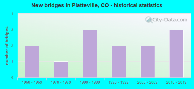
- New bridges - historical statistics
- 21960-1969
- 11970-1979
- 31980-1989
- 21990-1999
- 22000-2009
- 32010-2019
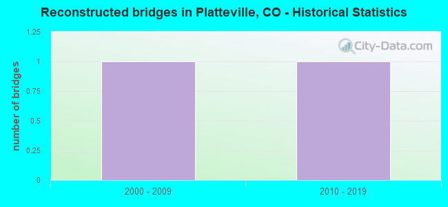
- Reconstructed bridges - Historical Statistics
- 12000-2009
- 12010-2019
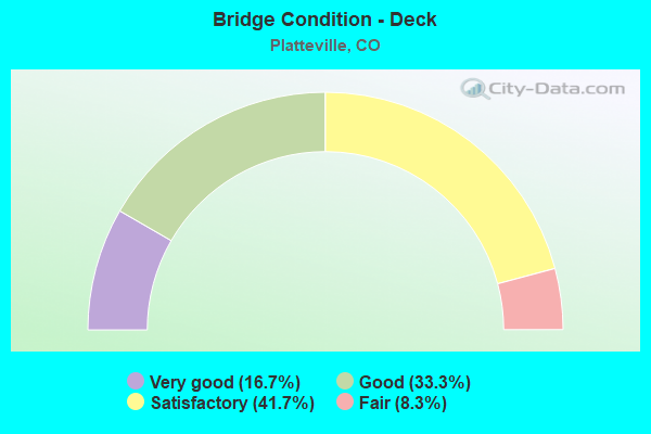
- Bridge Condition - Deck
- 16.7%Very good
- 33.3%Good
- 41.7%Satisfactory
- 8.3%Fair
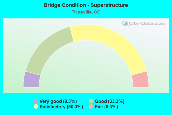
- Bridge Condition - Superstructure
- 8.3%Very good
- 33.3%Good
- 50.0%Satisfactory
- 8.3%Fair
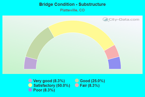
- Bridge Condition - Substructure
- 8.3%Very good
- 25.0%Good
- 50.0%Satisfactory
- 8.3%Fair
- 8.3%Poor
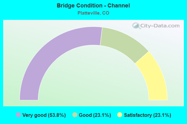
- Bridge Condition - Channel
- 53.8%Very good
- 23.1%Good
- 23.1%Satisfactory
Find on map >> Show street view
Structure Number: D-17-DF, Location: .2 MI W OF 85 (Lat: 40.206339, Lng: -104.828481), Route carried "on" structure: State highway 66B, Year Built: 1988, Status: Open, Structure Length: 11.47m (37.63ft), Average Daily Traffic: 9,100 (year 2020), Truck Traffic: 10%, Average Future Daily Traffic: 13,468 (year 2040), Design Load: HS 20, Features Intersected: SOUTH PLATTE RIVER, Facility Carried by Structure: SH 66 ML
Minimum Vertical Clearance: 30+ m (98+ ft), Kilometerpoint: 36.067, Lanes on structure: 2, Base Highway Network: Yes, Owner: State Highway Agency, Approaching Roadway Width: 12.2m (40.0ft), Skew: 3 degrees, Material/Design: Prestressed concrete continuous, Design/Construction: Stringer/Multi-beam, Number Of Spans In Main Unit: 3, Length of Maximum Span: 37.9m (124.3ft), Curb-To-Curb Width: 12.2m (40.0ft), Out-to-Out Width: 13.0m (42.7ft)
Condition: Deck: Good, Superstructure: Good, Substructure: Good, Channel: Satisfactory, Operating Rating: 57.9 metric tons, Method Used To Determine Operating Rating: Load Factor (LF), Inventory Rating: 26.7 metric tons, Method Used To Determine Inventory Rating: Load Factor (LF), Structural Evaluation: Equal to present minimum criteria, Deck Geometry: Somewhat better than minimum adequacy, Waterway Adequacy: Equal to present desirable criteria, Approach Roadway Alignment: Equal to present desirable criteria, Designated Inspection Frequency: Every 24 months, Inspection Date: December 2021, Deck Structure Type: Concrete Cast-file-Place, Wearing Surface/Protective System: Wearing Surface: Bituminous, Membrane: Preformed Fabric, Deck Protection: Epoxy Coated Reinforcing
Find on map >> Show street view
Structure Number: D-17-DH, Location: 2.3 MI S OF SH 66 (Lat: 40.173072, Lng: -104.816117), Route carried "on" structure: US 85C, Year Built: 1991, Status: Open, Structure Length: 0.98m (3.22ft), Average Daily Traffic: 20,000 (year 2020), Truck Traffic: 10%, Average Future Daily Traffic: 28,400 (year 2040), Design Load: HS 20+Mod, Features Intersected: Platte Valley Canal, Facility Carried by Structure: US 85 ML
Minimum Vertical Clearance: 30+ m (98+ ft), Kilometerpoint: 34.364, Lanes on structure: 4, Base Highway Network: Yes, Owner: State Highway Agency, Approaching Roadway Width: 23.2m (76.1ft), Skew: 22 degrees, Material/Design: Concrete, Design/Construction: Culvert, Number Of Spans In Main Unit: 1, Length of Maximum Span: 9.8m (32.2ft), Curb-To-Curb Width: 23.2m (76.1ft), Out-to-Out Width: 31.4m (103.0ft)
Condition: Channel: Very good, Culverts: Good, Operating Rating: 36.3 metric tons, Method Used To Determine Operating Rating: Field evaluation and documented engineering judgment, Inventory Rating: 32.7 metric tons, Method Used To Determine Inventory Rating: Field evaluation and documented engineering judgment, Structural Evaluation: Better than present minimum criteria, Deck Geometry: Superior to present desirable criteria, Waterway Adequacy: Equal to present desirable criteria, Approach Roadway Alignment: Equal to present desirable criteria, Designated Inspection Frequency: Every 48 months, Inspection Date: August 2021
Find on map >> Show street view
Structure Number: PLTVL30.0-25.0A, Location: 0.2 Mi E of US Hwy 85 (Lat: 40.202917, Lng: -104.815722), Route carried "on" structure: City street , Year Built: 1981, Year Reconstructed: 2013, Status: Open, Structure Length: 1.19m (3.90ft), Average Daily Traffic: 420 (year 2020), Truck Traffic: 56%, Average Future Daily Traffic: 596 (year 2040), Design Load: HS 20, Features Intersected: Platte Valley Canal, Facility Carried by Structure: County Road 30
Minimum Vertical Clearance: 30+ m (98+ ft), Kilometerpoint: 0.380, Lanes on structure: 2, Owner: Town or Township Highway Agency, Approaching Roadway Width: 7.9m (25.9ft), Material/Design: Steel, Design/Construction: Stringer/Multi-beam, Number Of Spans In Main Unit: 1, Length of Maximum Span: 11.4m (37.4ft), Curb-To-Curb Width: 9.2m (30.2ft), Out-to-Out Width: 9.4m (30.8ft)
Condition: Deck: Good, Superstructure: Good, Substructure: Good, Channel: Very good, Operating Rating: 67.9 metric tons, Method Used To Determine Operating Rating: Load Factor (LF), Inventory Rating: 40.7 metric tons, Method Used To Determine Inventory Rating: Load Factor (LF), Structural Evaluation: Better than present minimum criteria, Deck Geometry: Equal to present minimum criteria, Waterway Adequacy: Equal to present desirable criteria, Approach Roadway Alignment: Equal to present desirable criteria, Designated Inspection Frequency: Every 24 months, Inspection Date: March 2022, Deck Structure Type: Concrete Cast-file-Place, Wearing Surface/Protective System: Wearing Surface: Monolithic Concrete
Find on map >> Show street view
Structure Number: PLTVL32.0-25.0A, Location: 0.2 Mi E of US Hwy 85 (Lat: 40.217417, Lng: -104.817500), Route carried "on" structure: City street , Year Built: 1987, Year Reconstructed: 2015, Status: Open, Structure Length: 0.90m (2.95ft), Average Daily Traffic: 2,986 (year 2020), Truck Traffic: 52%, Average Future Daily Traffic: 4,240 (year 2040), Features Intersected: Platte Valley Canal, Facility Carried by Structure: County Road 32
Minimum Vertical Clearance: 30+ m (98+ ft), Kilometerpoint: 1.431, Lanes on structure: 2, Owner: Town or Township Highway Agency, Approaching Roadway Width: 7.0m (23.0ft), Skew: 1 degrees, Material/Design: Steel, Design/Construction: Stringer/Multi-beam, Number Of Spans In Main Unit: 1, Length of Maximum Span: 8.0m (26.2ft), Curb-To-Curb Width: 8.9m (29.2ft), Out-to-Out Width: 9.3m (30.5ft)
Condition: Deck: Very good, Superstructure: Satisfactory, Substructure: Satisfactory, Channel: Very good, Inventory Rating: 73.7 metric tons, Method Used To Determine Inventory Rating: Load Factor (LF), Structural Evaluation: Equal to present minimum criteria, Deck Geometry: Meets minimum limits, Waterway Adequacy: Equal to present desirable criteria, Approach Roadway Alignment: Equal to present desirable criteria, Designated Inspection Frequency: Every 24 months, Inspection Date: March 2022, Deck Structure Type: Concrete Cast-file-Place, Wearing Surface/Protective System: Wearing Surface: Bituminous
Find on map >> Show street view
Structure Number: PLTVL32.5_21.0B, Location: 0.9 Mi E of Co Rd 21 (Lat: 40.225000, Lng: -104.851111), Route carried "on" structure: City street , Year Built: 1995, Status: Open, Structure Length: 10.15m (33.30ft), Average Daily Traffic: 3,454 (year 2020), Truck Traffic: 27%, Average Future Daily Traffic: 4,905 (year 2040), Design Load: HS 20, Features Intersected: South Platte River, Facility Carried by Structure: County Road 32.5
Minimum Vertical Clearance: 30+ m (98+ ft), Kilometerpoint: 1.392, Lanes on structure: 2, Owner: Town or Township Highway Agency, Approaching Roadway Width: 7.6m (24.9ft), Skew: 2 degrees, Material/Design: Prestressed concrete continuous, Design/Construction: Stringer/Multi-beam, Number Of Spans In Main Unit: 3, Length of Maximum Span: 32.9m (107.9ft), Curb-To-Curb Width: 11.1m (36.4ft), Out-to-Out Width: 11.8m (38.7ft)
Condition: Deck: Good, Superstructure: Good, Substructure: Satisfactory, Channel: Very good, Operating Rating: 80.3 metric tons, Method Used To Determine Operating Rating: Load Factor (LF), Inventory Rating: 18.4 metric tons, Method Used To Determine Inventory Rating: Load Factor (LF), Structural Evaluation: Somewhat better than minimum adequacy, Deck Geometry: Somewhat better than minimum adequacy, Waterway Adequacy: Equal to present desirable criteria, Approach Roadway Alignment: Equal to present desirable criteria, Designated Inspection Frequency: Every 24 months, Inspection Date: March 2022, Deck Structure Type: Concrete Cast-file-Place, Wearing Surface/Protective System: Wearing Surface: Bituminous, Membrane: Built-up, Deck Protection: Epoxy Coated Reinforcing
Find on map >> Show street view
Structure Number: PLTVL32.5_23.0A, Location: 0.6 Mi E of Co Rd 23 (Lat: 40.224639, Lng: -104.837333), Route carried "on" structure: City street , Year Built: 2004, Status: Open, Structure Length: 1.22m (4.00ft), Average Daily Traffic: 3,358 (year 2020), Truck Traffic: 24%, Average Future Daily Traffic: 4,768 (year 2040), Design Load: HS 20, Features Intersected: Farmers Independent Ditc, Facility Carried by Structure: County Road 32.5
Minimum Vertical Clearance: 30+ m (98+ ft), Kilometerpoint: 2.601, Lanes on structure: 2, Owner: Town or Township Highway Agency, Approaching Roadway Width: 7.0m (23.0ft), Skew: 4 degrees, Material/Design: Steel, Design/Construction: Stringer/Multi-beam, Number Of Spans In Main Unit: 1, Length of Maximum Span: 10.7m (35.1ft), Curb-To-Curb Width: 11.9m (39.0ft), Out-to-Out Width: 12.3m (40.4ft)
Condition: Deck: Fair, Superstructure: Fair, Substructure: Satisfactory, Channel: Good, Operating Rating: 59.7 metric tons, Method Used To Determine Operating Rating: Load Factor (LF), Inventory Rating: 35.7 metric tons, Method Used To Determine Inventory Rating: Load Factor (LF), Structural Evaluation: Somewhat better than minimum adequacy, Deck Geometry: Somewhat better than minimum adequacy, Waterway Adequacy: Equal to present desirable criteria, Approach Roadway Alignment: Equal to present desirable criteria, Designated Inspection Frequency: Every 24 months, Inspection Date: March 2022, Deck Structure Type: Corrugated Steel, Wearing Surface/Protective System: Wearing Surface: Bituminous
Find on map >> Show street view
Structure Number: WEL024.5_025.0A, Location: 50 Ft E of Co Rd 25.5 (Lat: 40.166861, Lng: -104.820250), Route carried "on" structure: County highway , Year Built: 2010, Status: Open, Structure Length: 1.43m (4.69ft), Average Daily Traffic: 78 (year 2020), Truck Traffic: 36%, Average Future Daily Traffic: 111 (year 2040), Design Load: HS 20, Features Intersected: Platte Valley Canal, Facility Carried by Structure: County Road 24.5
Minimum Vertical Clearance: 30+ m (98+ ft), Kilometerpoint: 0.399, Lanes on structure: 2, Owner: County Highway Agency, Approaching Roadway Width: 6.7m (22.0ft), Skew: 3 degrees, Material/Design: Steel, Design/Construction: Stringer/Multi-beam, Number Of Spans In Main Unit: 1, Length of Maximum Span: 13.4m (44.0ft), Curb-To-Curb Width: 8.7m (28.5ft), Out-to-Out Width: 9.0m (29.5ft)
Condition: Deck: Satisfactory, Superstructure: Satisfactory, Substructure: Satisfactory, Channel: Very good, Operating Rating: 48.8 metric tons, Method Used To Determine Operating Rating: Load Factor (LF), Inventory Rating: 29.2 metric tons, Method Used To Determine Inventory Rating: Load Factor (LF), Structural Evaluation: Equal to present minimum criteria, Deck Geometry: Better than present minimum criteria, Waterway Adequacy: Equal to present desirable criteria, Approach Roadway Alignment: Equal to present desirable criteria, Designated Inspection Frequency: Every 24 months, Inspection Date: March 2020, Deck Structure Type: Corrugated Steel, Wearing Surface/Protective System: Wearing Surface: Gravel
Find on map >> Show street view
Structure Number: WEL026.0_025.0A, Location: 0.1 Mi E of US Hwy 85 (Lat: 40.174028, Lng: -104.815194), Route carried "on" structure: County highway , Year Built: 2017, Status: Open, Structure Length: 1.42m (4.66ft), Average Daily Traffic: 243 (year 2020), Truck Traffic: 43%, Average Future Daily Traffic: 345 (year 2040), Features Intersected: Platte Valley Canal, Facility Carried by Structure: County Road 26
Minimum Vertical Clearance: 30+ m (98+ ft), Kilometerpoint: 0.803, Lanes on structure: 2, Owner: County Highway Agency, Approaching Roadway Width: 9.1m (29.9ft), Skew: 2 degrees, Material/Design: Prestressed concrete, Design/Construction: Box Beam or Girders - Multiple, Number Of Spans In Main Unit: 1, Length of Maximum Span: 12.6m (41.3ft), Curb-To-Curb Width: 9.1m (29.9ft), Out-to-Out Width: 10.1m (33.1ft)
Condition: Deck: Very good, Superstructure: Very good, Substructure: Very good, Channel: Very good, Operating Rating: 65.4 metric tons, Method Used To Determine Operating Rating: Load and Resistance Factor Rating (LRFR) rating reported by rating factor(RF) method using HL-93 loadings, Inventory Rating: 45.4 metric tons, Method Used To Determine Inventory Rating: Load and Resistance Factor Rating (LRFR) rating reported by rating factor(RF) method using HL-93 loadings, Structural Evaluation: Equal to present desirable criteria, Deck Geometry: Equal to present minimum criteria, Waterway Adequacy: Equal to present desirable criteria, Approach Roadway Alignment: Equal to present desirable criteria, Designated Inspection Frequency: Every 24 months, Inspection Date: April 2020, Deck Structure Type: Concrete Cast-file-Place, Wearing Surface/Protective System: Wearing Surface: Bituminous, Membrane: Built-up, Deck Protection: Epoxy Coated Reinforcing
Find on map >> Show street view
Structure Number: WEL028.0-023.0A, Location: 0.7 Mi E of Co Rd 23 (Lat: 40.188333, Lng: -104.829722), Route carried "on" structure: County highway , Year Built: 1965, Status: Open, Structure Length: 10.49m (34.42ft), Average Daily Traffic: 1,542 (year 2020), Truck Traffic: 37%, Average Future Daily Traffic: 2,190 (year 2040), Design Load: HS 20, Features Intersected: South Platte River, Facility Carried by Structure: County Road 28
Minimum Vertical Clearance: 30+ m (98+ ft), Kilometerpoint: 6.875, Lanes on structure: 2, Owner: County Highway Agency, Approaching Roadway Width: 7.6m (24.9ft), Material/Design: Prestressed concrete, Design/Construction: Tee Beam, Number Of Spans In Main Unit: 7, Length of Maximum Span: 14.5m (47.6ft), Curb-To-Curb Width: 9.6m (31.5ft), Out-to-Out Width: 9.8m (32.2ft)
Condition: Deck: Satisfactory, Superstructure: Satisfactory, Substructure: Fair, Channel: Satisfactory, Operating Rating: 36.3 metric tons, Method Used To Determine Operating Rating: Field evaluation and documented engineering judgment, Inventory Rating: 32.7 metric tons, Method Used To Determine Inventory Rating: Field evaluation and documented engineering judgment, Structural Evaluation: Somewhat better than minimum adequacy, Deck Geometry: Somewhat better than minimum adequacy, Waterway Adequacy: Equal to present desirable criteria, Approach Roadway Alignment: Equal to present desirable criteria, Designated Inspection Frequency: Every 24 months, Inspection Date: June 2020, Deck Structure Type: Concrete Cast-file-Place, Wearing Surface/Protective System: Wearing Surface: Bituminous
Find on map >> Show street view
Structure Number: WEL028.0_025.0A, Location: 0.1 Mi E of US Hwy 85 (Lat: 40.188333, Lng: -104.817611), Route carried "on" structure: County highway , Year Built: 2005, Status: Open, Structure Length: 1.34m (4.40ft), Average Daily Traffic: 246 (year 2020), Truck Traffic: 51%, Average Future Daily Traffic: 349 (year 2040), Design Load: HS 20, Features Intersected: Platte Valley Canal, Facility Carried by Structure: County Road 28
Minimum Vertical Clearance: 30+ m (98+ ft), Kilometerpoint: 7.866, Lanes on structure: 2, Owner: County Highway Agency, Approaching Roadway Width: 8.2m (26.9ft), Material/Design: Steel, Design/Construction: Stringer/Multi-beam, Number Of Spans In Main Unit: 1, Length of Maximum Span: 12.5m (41.0ft), Curb-To-Curb Width: 10.7m (35.1ft), Out-to-Out Width: 10.7m (35.1ft)
Condition: Deck: Satisfactory, Superstructure: Satisfactory, Substructure: Satisfactory, Channel: Good, Operating Rating: 62.0 metric tons, Method Used To Determine Operating Rating: Load Factor (LF), Inventory Rating: 37.1 metric tons, Method Used To Determine Inventory Rating: Load Factor (LF), Structural Evaluation: Equal to present minimum criteria, Deck Geometry: Better than present minimum criteria, Waterway Adequacy: Equal to present desirable criteria, Approach Roadway Alignment: Equal to present desirable criteria, Designated Inspection Frequency: Every 24 months, Inspection Date: March 2020, Deck Structure Type: Corrugated Steel, Wearing Surface/Protective System: Wearing Surface: Gravel
Find on map >> Show street view
Structure Number: WEL029.0_034.0A, Location: 0.5 Mi N of Co Rd 34 (Lat: 40.240306, Lng: -104.792028), Route carried "on" structure: County highway , Year Built: 2014, Status: Open, Structure Length: 1.21m (3.97ft), Average Daily Traffic: 211 (year 2020), Truck Traffic: 45%, Average Future Daily Traffic: 300 (year 2040), Features Intersected: Platte Valley Canal, Facility Carried by Structure: Co Rd 29
Minimum Vertical Clearance: 30+ m (98+ ft), Kilometerpoint: 2.526, Lanes on structure: 2, Owner: County Highway Agency, Approaching Roadway Width: 6.4m (21.0ft), Skew: 2 degrees, Material/Design: Steel, Design/Construction: Stringer/Multi-beam, Number Of Spans In Main Unit: 1, Length of Maximum Span: 11.3m (37.1ft), Curb-To-Curb Width: 9.4m (30.8ft), Out-to-Out Width: 9.7m (31.8ft)
Condition: Deck: Good, Superstructure: Good, Substructure: Good, Channel: Very good, Operating Rating: 59.3 metric tons, Method Used To Determine Operating Rating: Load Factor (LF), Inventory Rating: 35.5 metric tons, Method Used To Determine Inventory Rating: Load Factor (LF), Structural Evaluation: Better than present minimum criteria, Deck Geometry: Equal to present minimum criteria, Waterway Adequacy: Equal to present desirable criteria, Approach Roadway Alignment: Equal to present desirable criteria, Designated Inspection Frequency: Every 24 months, Inspection Date: June 2020, Deck Structure Type: Corrugated Steel, Wearing Surface/Protective System: Wearing Surface: Bituminous
Find on map >> Show street view
Structure Number: WEL034.0-017.0A, Location: 0.3 Mi E of Co Rd 17 (Lat: 40.233056, Lng: -104.899167), Route carried "on" structure: County highway , Year Built: 1960, Status: Open, Structure Length: 8.96m (29.40ft), Average Daily Traffic: 1,759 (year 2021), Truck Traffic: 39%, Average Future Daily Traffic: 2,498 (year 2041), Design Load: HS 20, Features Intersected: St. Vrain Creek, Facility Carried by Structure: County Road 34
Minimum Vertical Clearance: 30+ m (98+ ft), Kilometerpoint: 6.029, Lanes on structure: 2, Owner: County Highway Agency, Approaching Roadway Width: 7.3m (24.0ft), Material/Design: Prestressed concrete, Design/Construction: Tee Beam, Number Of Spans In Main Unit: 6, Length of Maximum Span: 14.7m (48.2ft), Curb-To-Curb Width: 9.0m (29.5ft), Out-to-Out Width: 9.2m (30.2ft)
Condition: Deck: Satisfactory, Superstructure: Satisfactory, Substructure: Poor, Channel: Satisfactory, Operating Rating: 32.7 metric tons, Method Used To Determine Operating Rating: Field evaluation and documented engineering judgment, Inventory Rating: 32.7 metric tons, Method Used To Determine Inventory Rating: Field evaluation and documented engineering judgment, Structural Evaluation: Meets minimum limits, Deck Geometry: Somewhat better than minimum adequacy, Waterway Adequacy: Equal to present desirable criteria, Approach Roadway Alignment: Equal to present desirable criteria, Designated Inspection Frequency: Every 24 months, Inspection Date: June 2020, Deck Structure Type: Concrete Cast-file-Place, Wearing Surface/Protective System: Wearing Surface: Bituminous
Find on map >> Show street view
Structure Number: WEL034.0-025.0A, Location: 0.2 Mi E of US Hwy 85 (Lat: 40.231944, Lng: -104.816083), Route carried "on" structure: County highway , Year Built: 1974, Status: Open, Structure Length: 0.92m (3.02ft), Average Daily Traffic: 191 (year 2021), Truck Traffic: 42%, Average Future Daily Traffic: 271 (year 2041), Design Load: HS 20, Features Intersected: Platte Valley Canal, Facility Carried by Structure: County Road 34
Minimum Vertical Clearance: 30+ m (98+ ft), Kilometerpoint: 0.034, Lanes on structure: 2, Owner: County Highway Agency, Approaching Roadway Width: 6.1m (20.0ft), Material/Design: Steel, Design/Construction: Stringer/Multi-beam, Number Of Spans In Main Unit: 1, Length of Maximum Span: 8.7m (28.5ft), Curb-To-Curb Width: 9.6m (31.5ft), Out-to-Out Width: 9.8m (32.2ft)
Condition: Deck: Satisfactory, Superstructure: Satisfactory, Substructure: Satisfactory, Channel: Good, Operating Rating: 41.7 metric tons, Method Used To Determine Operating Rating: Load Factor (LF), Inventory Rating: 24.9 metric tons, Method Used To Determine Inventory Rating: Load Factor (LF), Structural Evaluation: Equal to present minimum criteria, Deck Geometry: Equal to present minimum criteria, Waterway Adequacy: Equal to present desirable criteria, Approach Roadway Alignment: Equal to present minimum criteria, Designated Inspection Frequency: Every 24 months, Inspection Date: March 2022, Deck Structure Type: Corrugated Steel, Wearing Surface/Protective System: Wearing Surface: Gravel