Bridge Statistics for Point Pleasant, West Virginia (WV)
Condition, Traffic, Stress, Structural Evaluation, Project Costs
- National Bridge Inventory (NBI) Statistics
- 18Number of bridges
- 545ft / 166mTotal length
- $3,405,000Total costs
- 136,751Total average daily traffic
- 17,649Total average daily truck traffic
- National Bridge Inventory (NBI) Registered Bridges for Point Pleasant
- No street view available for this location
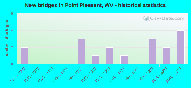
- New bridges - historical statistics
- 21900-1909
- 31940-1949
- 11950-1959
- 21960-1969
- 11970-1979
- 31990-1999
- 22000-2009
- 42010-2019
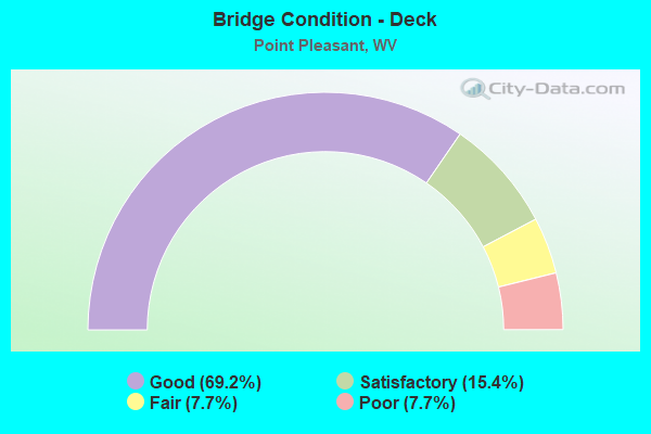
- Bridge Condition - Deck
- 69.2%Good
- 15.4%Satisfactory
- 7.7%Fair
- 7.7%Poor
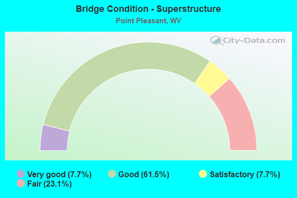
- Bridge Condition - Superstructure
- 7.7%Very good
- 61.5%Good
- 7.7%Satisfactory
- 23.1%Fair
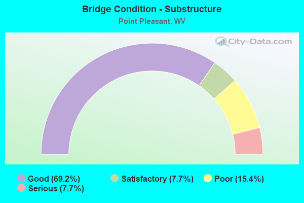
- Bridge Condition - Substructure
- 69.2%Good
- 7.7%Satisfactory
- 15.4%Poor
- 7.7%Serious
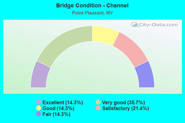
- Bridge Condition - Channel
- 14.3%Excellent
- 35.7%Very good
- 14.3%Good
- 21.4%Satisfactory
- 14.3%Fair
Find on map >> Show street view
Structure Number: 27A027, Location: 0.42 MI N OF WV 62 (Lat: 38.863019, Lng: -82.121419), Route carried "on" structure: County highway 16, Year Built: 1965, Status: Posted for load, Structure Length: 1.59m (5.22ft), Average Daily Traffic: 1,900 (year 2020), Truck Traffic: 6%, Average Future Daily Traffic: 2,622 (year 2040), Features Intersected: CROOKED CREEK
Minimum Vertical Clearance: 30+ m (98+ ft), Kilometerpoint: 0.676, Lanes on structure: 2, Owner: State Highway Agency, Approaching Roadway Width: 6.1m (20.0ft), Material/Design: Steel, Design/Construction: Stringer/Multi-beam, Number Of Spans In Main Unit: 1, Length of Maximum Span: 14.5m (47.6ft), Curb or Sidewalk Widths: Left: 0.3m (1.0ft), Right: 0.3m (1.0ft), Curb-To-Curb Width: 6.1m (20.0ft), Out-to-Out Width: 6.8m (22.3ft)
Condition: Deck: Poor, Superstructure: Fair, Substructure: Serious, Channel: Satisfactory, Operating Rating: 13.6 metric tons, Method Used To Determine Operating Rating: Load Factor (LF), Inventory Rating: 12.7 metric tons, Method Used To Determine Inventory Rating: Load Factor (LF), Structural Evaluation: High priority of corrective action, Deck Geometry: High priority of replacement, Waterway Adequacy: Equal to present desirable criteria, Approach Roadway Alignment: Equal to present minimum criteria, Bridge Posting: Required (Relationship of Operating Rating to Maximum Legal Load: > 39.9% below), Length Of Structure Improvement: 2.13m (6.99ft), Designated Inspection Frequency: Every 24 months, Other Special Inspection Frequency: Every 12 months, Inspection Date: September 2021, Other Special Inspection Date: September 2021, Bridge Improvement Cost: $550,000, Roadway Improvement Cost: $100,000, Total Project Cost: $650,000 ( Estimate for 2020), Deck Structure Type: Concrete Cast-file-Place, Wearing Surface/Protective System: Wearing Surface: Monolithic Concrete
Find on map >> Show street view
Structure Number: 27A061, Location: 0.03 MI N OF CR 34 (Lat: 38.808061, Lng: -82.096639), Route carried "on" structure: Spur State highway 817, Year Built: 1957, Status: Open, Structure Length: 0.76m (2.49ft), Average Daily Traffic: 400 (year 2020), Truck Traffic: 7%, Average Future Daily Traffic: 420 (year 2040), Design Load: HS 15, Features Intersected: THREEMILE CREEK
Minimum Vertical Clearance: 30+ m (98+ ft), Kilometerpoint: 23.287, Lanes on structure: 2, Owner: State Highway Agency, Approaching Roadway Width: 8.5m (27.9ft), Material/Design: Concrete continuous, Design/Construction: Culvert, Number Of Spans In Main Unit: 2, Length of Maximum Span: 3.7m (12.1ft)
Condition: Channel: Fair, Culverts: Satisfactory, Operating Rating: 63.5 metric tons, Method Used To Determine Operating Rating: Field evaluation and documented engineering judgment, Inventory Rating: 29.0 metric tons, Method Used To Determine Inventory Rating: Field evaluation and documented engineering judgment, Structural Evaluation: Equal to present minimum criteria, Waterway Adequacy: Equal to present minimum criteria, Approach Roadway Alignment: Equal to present desirable criteria, Length Of Structure Improvement: 0.76m (2.49ft), Designated Inspection Frequency: Every 24 months, Inspection Date: July 2021, Bridge Improvement Cost: $150,000, Roadway Improvement Cost: $50,000, Total Project Cost: $200,000 ( Estimate for 2019)
Find on map >> Show street view
Structure Number: 27A063, Location: 0.40 MI W OF WV 2 (Lat: 38.834939, Lng: -82.147939), Route carried "on" structure: US 3500, Year Built: 1969, Status: Open, Structure Length: 59.87m (196.42ft), Average Daily Traffic: 24,200 (year 2018), Truck Traffic: 25%, Average Future Daily Traffic: 34,400 (year 2038), Design Load: HS 20, Features Intersected: OHIO RIVER, Facility Carried by Structure: US 35
Minimum Vertical Clearance: 5.26m (17.26ft), Kilometerpoint: 28.888, Lanes on structure: 4, Base Highway Network: Yes, Owner: State Highway Agency, Approaching Roadway Width: 8.8m (28.9ft), Skew: 30 degrees, Navigation Control: Yes ( Vertical Clearance: 21.0m (68.9ft), Horizontal Clearance: 265.2m (870.1ft)), Material/Design: Steel, Design/Construction: Truss - Thru, Number Of Spans In Main Unit: 1, Number Of Approach Spans: 4, Length of Maximum Span: 274.3m (899.9ft), Curb-To-Curb Width: 18.2m (59.7ft), Out-to-Out Width: 19.6m (64.3ft)
Condition: Deck: Good, Superstructure: Fair, Substructure: Good, Channel: Good, Operating Rating: 51.7 metric tons, Method Used To Determine Operating Rating: Allowable Stress (AS), Inventory Rating: 30.8 metric tons, Method Used To Determine Inventory Rating: Allowable Stress (AS), Structural Evaluation: Somewhat better than minimum adequacy, Deck Geometry: Meets minimum limits, Waterway Adequacy: Superior to present desirable criteria, Approach Roadway Alignment: Equal to present desirable criteria, Length Of Structure Improvement: 59.86m (196.39ft), Designated Inspection Frequency: Every 24 months, Critical Feature Inspection Frequency: Every 12 months, Underwater Inspection Frequency: Every 60 months, Other Special Inspection Frequency: Every 12 months, Inspection Date: June 2020, Critical Feature Inspection Date: June 2021, Underwater Inspection Date: August 2019, Other Special Inspection Date: June 2021, Bridge Improvement Cost: $30,000, Total Project Cost: $30,000 ( Estimate for 2018), Deck Structure Type: Concrete Cast-file-Place, Wearing Surface/Protective System: Wearing Surface: Latex Concrete, Deck Protection: Internally Sealed
Find on map >> Show street view
Structure Number: 27A086, Location: 0.99 MI N OF CR 62/2 (Lat: 38.896639, Lng: -82.122681), Route carried "on" structure: State highway 6200, Year Built: 1942, Status: Posted for load, Structure Length: 5.36m (17.59ft), Average Daily Traffic: 6,500 (year 2018), Truck Traffic: 6%, Average Future Daily Traffic: 8,450 (year 2038), Design Load: H 15, Features Intersected: OLDTOWN CREEK, Facility Carried by Structure: WV 62
Minimum Vertical Clearance: 30+ m (98+ ft), Kilometerpoint: 37.852, Lanes on structure: 2, Owner: State Highway Agency, Approaching Roadway Width: 6.7m (22.0ft), Skew: 3 degrees, Material/Design: Concrete, Design/Construction: Tee Beam, Number Of Spans In Main Unit: 2, Number Of Approach Spans: 1, Length of Maximum Span: 17.4m (57.1ft), Curb or Sidewalk Widths: Left: 0.5m (1.6ft), Right: 0.5m (1.6ft), Curb-To-Curb Width: 8.4m (27.6ft), Out-to-Out Width: 10.9m (35.8ft)
Condition: Deck: Satisfactory, Superstructure: Satisfactory, Substructure: Poor, Channel: Fair, Operating Rating: 43.5 metric tons, Method Used To Determine Operating Rating: Load Factor (LF), Inventory Rating: 26.3 metric tons, Method Used To Determine Inventory Rating: Load Factor (LF), Structural Evaluation: Meets minimum limits, Deck Geometry: High priority of replacement, Waterway Adequacy: Superior to present desirable criteria, Approach Roadway Alignment: Equal to present desirable criteria, Bridge Posting: Required (Relationship of Operating Rating to Maximum Legal Load: 0.1 - 9.9% below), Length Of Structure Improvement: 5.36m (17.59ft), Designated Inspection Frequency: Every 24 months, Inspection Date: November 2020, Bridge Improvement Cost: $1,650,000, Roadway Improvement Cost: $100,000, Total Project Cost: $1,750,000 ( Estimate for 2021), Deck Structure Type: Concrete Cast-file-Place, Wearing Surface/Protective System: Wearing Surface: Bituminous
Find on map >> Show street view
Structure Number: 27A116, Location: 1.07 MI E OF CR 34/2 (Lat: 38.804650, Lng: -82.098250), Route carried "on" structure: County highway 34, Year Built: 1977, Status: Open, Structure Length: 1.37m (4.49ft), Average Daily Traffic: 200 (year 2020), Truck Traffic: 6%, Average Future Daily Traffic: 276 (year 2040), Design Load: H 20, Features Intersected: THREEMILE CREEK
Minimum Vertical Clearance: 30+ m (98+ ft), Kilometerpoint: 3.718, Lanes on structure: 2, Owner: State Highway Agency, Approaching Roadway Width: 6.4m (21.0ft), Skew: 3 degrees, Material/Design: Prestressed concrete, Design/Construction: Slab, Number Of Spans In Main Unit: 2, Length of Maximum Span: 6.1m (20.0ft), Curb-To-Curb Width: 5.9m (19.4ft), Out-to-Out Width: 6.1m (20.0ft)
Condition: Deck: Good, Superstructure: Good, Substructure: Poor, Channel: Satisfactory, Operating Rating: 68.9 metric tons, Method Used To Determine Operating Rating: Load Factor (LF), Inventory Rating: 39.9 metric tons, Method Used To Determine Inventory Rating: Load Factor (LF), Structural Evaluation: Meets minimum limits, Deck Geometry: High priority of corrective action, Waterway Adequacy: Better than present minimum criteria, Approach Roadway Alignment: Somewhat better than minimum adequacy, Length Of Structure Improvement: 1.37m (4.49ft), Designated Inspection Frequency: Every 24 months, Inspection Date: August 2021, Bridge Improvement Cost: $450,000, Roadway Improvement Cost: $50,000, Total Project Cost: $500,000 ( Estimate for 2019), Deck Structure Type: Other, Wearing Surface/Protective System: Wearing Surface: Bituminous
Find on map >> Show street view
Structure Number: 27A135, Location: 0.02 MI N OF CR 14 (Lat: 38.896489, Lng: -82.077839), Route carried "on" structure: County highway 13, Year Built: 1996, Status: Open, Structure Length: 2.98m (9.78ft), Average Daily Traffic: 1,200 (year 2018), Truck Traffic: 5%, Average Future Daily Traffic: 1,560 (year 2038), Design Load: HS 25 or greater, Features Intersected: OLDTOWN CREEK
Minimum Vertical Clearance: 30+ m (98+ ft), Kilometerpoint: 8.288, Lanes on structure: 2, Owner: State Highway Agency, Approaching Roadway Width: 7.3m (24.0ft), Material/Design: Prestressed concrete, Design/Construction: Box Beam or Girders - Multiple, Number Of Spans In Main Unit: 1, Length of Maximum Span: 28.7m (94.2ft), Curb-To-Curb Width: 7.1m (23.3ft), Out-to-Out Width: 7.5m (24.6ft)
Condition: Deck: Good, Superstructure: Good, Substructure: Good, Channel: Satisfactory, Operating Rating: 88.9 metric tons, Method Used To Determine Operating Rating: Load Factor (LF), Inventory Rating: 61.7 metric tons, Method Used To Determine Inventory Rating: Load Factor (LF), Structural Evaluation: Better than present minimum criteria, Deck Geometry: High priority of corrective action, Waterway Adequacy: Equal to present desirable criteria, Approach Roadway Alignment: Equal to present minimum criteria, Designated Inspection Frequency: Every 48 months, Inspection Date: July 2020, Deck Structure Type: Other, Wearing Surface/Protective System: Wearing Surface: Monolithic Concrete, Deck Protection: Epoxy Coated Reinforcing
Find on map >> Show street view
Structure Number: 27A146, Location: 0.02 MILE N. OF US 35 (Lat: 38.837150, Lng: -82.139731), Route carried "on" structure: State highway 200, Year Built: 1999, Status: Open, Structure Length: 53.48m (175.46ft), Average Daily Traffic: 16,700 (year 2018), Truck Traffic: 8%, Average Future Daily Traffic: 25,050 (year 2038), Design Load: HS 25 or greater, Features Intersected: KANAWHA RIVER; 1ST ST, Facility Carried by Structure: WV 2
Minimum Vertical Clearance: 7.32m (24.02ft), Kilometerpoint: 33.104, Lanes on structure: 4, Lanes under structure: 2, Owner: State Highway Agency, Approaching Roadway Width: 22.9m (75.1ft), Skew: 30 degrees, Navigation Control: Yes ( Vertical Clearance: 21.0m (68.9ft), Horizontal Clearance: 182.9m (600.1ft)), Material/Design: Steel continuous, Design/Construction: Truss - Thru, Number Of Spans In Main Unit: 3, Number Of Approach Spans: 4, Length of Maximum Span: 208.2m (683.1ft), Curb or Sidewalk Widths: Left: 0.5m (1.6ft), Right: 1.5m (4.9ft), Curb-To-Curb Width: 19.5m (64.0ft), Out-to-Out Width: 22.9m (75.1ft)
Condition: Deck: Good, Superstructure: Good, Substructure: Good, Channel: Very good, Operating Rating: 82.5 metric tons, Method Used To Determine Operating Rating: Load Factor (LF), Inventory Rating: 29.0 metric tons, Method Used To Determine Inventory Rating: Load Factor (LF), Structural Evaluation: Better than present minimum criteria, Deck Geometry: Better than present minimum criteria, Underclear: Superior to present desirable criteria, Waterway Adequacy: Superior to present desirable criteria, Approach Roadway Alignment: Equal to present desirable criteria, Designated Inspection Frequency: Every 24 months, Critical Feature Inspection Frequency: Every 24 months, Underwater Inspection Frequency: Every 60 months, Inspection Date: May 2020, Critical Feature Inspection Date: May 2020, Underwater Inspection Date: July 2019, Deck Structure Type: Concrete Cast-file-Place, Wearing Surface/Protective System: Wearing Surface: Monolithic Concrete, Deck Protection: Epoxy Coated Reinforcing
Find on map >> Show street view
Structure Number: 27A178, Location: 0.18 MILE S OF CR 34 (Lat: 38.801081, Lng: -82.100550), Route carried "on" structure: US 35, Year Built: 2009, Status: Open, Structure Length: 12.63m (41.44ft), Average Daily Traffic: 7,150 (year 2018), Truck Traffic: 25%, Average Future Daily Traffic: 10,153 (year 2038), Design Load: HL 93, Features Intersected: THREEMILE CREEK
Minimum Vertical Clearance: 30+ m (98+ ft), Kilometerpoint: 22.724, Lanes on structure: 2, Base Highway Network: Yes, Owner: State Highway Agency, Approaching Roadway Width: 12.8m (42.0ft), Material/Design: Steel continuous, Design/Construction: Stringer/Multi-beam, Number Of Spans In Main Unit: 1, Number Of Approach Spans: 2, Length of Maximum Span: 48.0m (157.5ft), Curb-To-Curb Width: 12.8m (42.0ft), Out-to-Out Width: 13.6m (44.6ft)
Condition: Deck: Good, Superstructure: Good, Substructure: Good, Channel: Very good, Operating Rating: 53.5 metric tons, Method Used To Determine Operating Rating: Load and Resistance Factor (LRFR), Inventory Rating: 40.8 metric tons, Method Used To Determine Inventory Rating: Load and Resistance Factor (LRFR), Structural Evaluation: Better than present minimum criteria, Deck Geometry: Equal to present desirable criteria, Waterway Adequacy: Superior to present desirable criteria, Approach Roadway Alignment: Equal to present desirable criteria, Designated Inspection Frequency: Every 24 months, Inspection Date: December 2020, Deck Structure Type: Concrete Cast-file-Place, Wearing Surface/Protective System: Wearing Surface: Monolithic Concrete, Deck Protection: Epoxy Coated Reinforcing
Find on map >> Show street view
Structure Number: 27A179, Location: 0.18 MILE S OF CR 34 (Lat: 38.801200, Lng: -82.100331), Route carried "on" structure: US 35, Year Built: 2009, Status: Open, Structure Length: 12.63m (41.44ft), Average Daily Traffic: 7,150 (year 2018), Truck Traffic: 25%, Average Future Daily Traffic: 10,153 (year 2038), Design Load: HL 93, Features Intersected: THREEMILE CREEK
Minimum Vertical Clearance: 30+ m (98+ ft), Kilometerpoint: 22.724, Lanes on structure: 2, Base Highway Network: Yes, Owner: State Highway Agency, Approaching Roadway Width: 12.8m (42.0ft), Material/Design: Steel continuous, Design/Construction: Stringer/Multi-beam, Number Of Spans In Main Unit: 1, Number Of Approach Spans: 2, Length of Maximum Span: 48.0m (157.5ft), Curb-To-Curb Width: 12.8m (42.0ft), Out-to-Out Width: 13.6m (44.6ft)
Condition: Deck: Satisfactory, Superstructure: Very good, Substructure: Good, Channel: Excellent, Operating Rating: 53.5 metric tons, Method Used To Determine Operating Rating: Load and Resistance Factor (LRFR), Inventory Rating: 40.8 metric tons, Method Used To Determine Inventory Rating: Load and Resistance Factor (LRFR), Structural Evaluation: Better than present minimum criteria, Deck Geometry: Equal to present desirable criteria, Waterway Adequacy: Superior to present desirable criteria, Approach Roadway Alignment: Equal to present desirable criteria, Designated Inspection Frequency: Every 24 months, Inspection Date: December 2020, Deck Structure Type: Concrete Cast-file-Place, Wearing Surface/Protective System: Wearing Surface: Monolithic Concrete, Deck Protection: Epoxy Coated Reinforcing
Find on map >> Show street view
Structure Number: 27A182, Location: 0.81 M. N. of CR 62/22 (Lat: 38.854669, Lng: -82.132069), Route carried "on" structure: State highway 62, Year Built: 2011, Status: Open, Structure Length: 4.36m (14.30ft), Average Daily Traffic: 10,900 (year 2020), Truck Traffic: 7%, Average Future Daily Traffic: 11,445 (year 2040), Design Load: HL 93, Features Intersected: CROOKED CREEK
Minimum Vertical Clearance: 30+ m (98+ ft), Kilometerpoint: 33.040, Lanes on structure: 2, Owner: State Highway Agency, Approaching Roadway Width: 12.2m (40.0ft), Skew: 1 degrees, Material/Design: Steel, Design/Construction: Stringer/Multi-beam, Number Of Spans In Main Unit: 1, Length of Maximum Span: 42.1m (138.1ft), Curb or Sidewalk Widths: Left: 0.0m, Right: 1.5m (4.9ft), Curb-To-Curb Width: 11.9m (39.0ft), Out-to-Out Width: 14.0m (45.9ft)
Condition: Deck: Good, Superstructure: Good, Substructure: Good, Channel: Very good, Operating Rating: 52.6 metric tons, Method Used To Determine Operating Rating: Load and Resistance Factor (LRFR), Inventory Rating: 40.8 metric tons, Method Used To Determine Inventory Rating: Load and Resistance Factor (LRFR), Structural Evaluation: Better than present minimum criteria, Deck Geometry: Somewhat better than minimum adequacy, Waterway Adequacy: Equal to present desirable criteria, Approach Roadway Alignment: Equal to present desirable criteria, Designated Inspection Frequency: Every 24 months, Inspection Date: November 2021, Deck Structure Type: Concrete Cast-file-Place, Wearing Surface/Protective System: Wearing Surface: Monolithic Concrete, Deck Protection: Epoxy Coated Reinforcing
Find on map >> Show street view
Structure Number: 27A183, Location: 0.2 MILE N. OF CR 817 (Lat: 38.814719, Lng: -82.111750), Route carried "on" structure: US 35, Year Built: 2010, Status: Open, Structure Length: 3.35m (10.99ft), Average Daily Traffic: 7,150 (year 2018), Truck Traffic: 25%, Average Future Daily Traffic: 10,153 (year 2038), Design Load: HL 93, Features Intersected: TWO MILE CREEK
Minimum Vertical Clearance: 30+ m (98+ ft), Kilometerpoint: 24.655, Lanes on structure: 2, Base Highway Network: Yes, Owner: State Highway Agency, Approaching Roadway Width: 12.8m (42.0ft), Skew: 1 degrees, Material/Design: Steel, Design/Construction: Stringer/Multi-beam, Number Of Spans In Main Unit: 1, Length of Maximum Span: 32.5m (106.6ft), Curb-To-Curb Width: 12.8m (42.0ft), Out-to-Out Width: 13.6m (44.6ft)
Condition: Deck: Good, Superstructure: Good, Substructure: Good, Channel: Excellent, Operating Rating: 49.9 metric tons, Method Used To Determine Operating Rating: Load and Resistance Factor (LRFR), Inventory Rating: 38.1 metric tons, Method Used To Determine Inventory Rating: Load and Resistance Factor (LRFR), Structural Evaluation: Better than present minimum criteria, Deck Geometry: Equal to present desirable criteria, Waterway Adequacy: Superior to present desirable criteria, Approach Roadway Alignment: Equal to present desirable criteria, Designated Inspection Frequency: Every 24 months, Inspection Date: Febuary 2021, Deck Structure Type: Concrete Cast-file-Place, Wearing Surface/Protective System: Wearing Surface: Monolithic Concrete, Deck Protection: Epoxy Coated Reinforcing
Find on map >> Show street view
Structure Number: 27A184, Location: 0.2 MILE NORTH OF CR 817 (Lat: 38.814531, Lng: -82.111881), Route carried "on" structure: US 35, Year Built: 2010, Status: Open, Structure Length: 3.35m (10.99ft), Average Daily Traffic: 7,150 (year 2018), Truck Traffic: 25%, Average Future Daily Traffic: 10,153 (year 2038), Design Load: HL 93, Features Intersected: TWO MILE CREEK
Minimum Vertical Clearance: 30+ m (98+ ft), Kilometerpoint: 24.655, Lanes on structure: 2, Base Highway Network: Yes, Owner: State Highway Agency, Approaching Roadway Width: 12.8m (42.0ft), Skew: 1 degrees, Material/Design: Steel, Design/Construction: Stringer/Multi-beam, Number Of Spans In Main Unit: 1, Length of Maximum Span: 32.5m (106.6ft), Curb-To-Curb Width: 12.8m (42.0ft), Out-to-Out Width: 13.6m (44.6ft)
Condition: Deck: Good, Superstructure: Good, Substructure: Good, Channel: Good, Operating Rating: 49.9 metric tons, Method Used To Determine Operating Rating: Load and Resistance Factor (LRFR), Inventory Rating: 38.1 metric tons, Method Used To Determine Inventory Rating: Load and Resistance Factor (LRFR), Structural Evaluation: Better than present minimum criteria, Deck Geometry: Equal to present desirable criteria, Waterway Adequacy: Superior to present desirable criteria, Approach Roadway Alignment: Equal to present desirable criteria, Designated Inspection Frequency: Every 24 months, Inspection Date: Febuary 2021, Deck Structure Type: Concrete Cast-file-Place, Wearing Surface/Protective System: Wearing Surface: Monolithic Concrete, Deck Protection: Epoxy Coated Reinforcing
Find on map >> Show street view
Structure Number: 27A185, Location: 2.47 MILE E. OF CR 25 (Lat: 38.778611, Lng: -82.093950), Route carried "on" structure: County highway 36, Year Built: 2011, Status: Open, Structure Length: 1.33m (4.36ft), Average Daily Traffic: 200 (year 2019), Truck Traffic: 5%, Average Future Daily Traffic: 244 (year 2039), Design Load: HL 93, Features Intersected: LOWER FIVEMILE CREEK
Minimum Vertical Clearance: 30+ m (98+ ft), Kilometerpoint: 14.500, Lanes on structure: 1, Owner: State Highway Agency, Approaching Roadway Width: 4.6m (15.1ft), Material/Design: Prestressed concrete, Design/Construction: Box Beam or Girders - Multiple, Number Of Spans In Main Unit: 1, Length of Maximum Span: 12.2m (40.0ft), Curb-To-Curb Width: 4.5m (14.8ft), Out-to-Out Width: 4.7m (15.4ft)
Condition: Deck: Good, Superstructure: Good, Substructure: Good, Channel: Very good, Operating Rating: 52.6 metric tons, Method Used To Determine Operating Rating: Load and Resistance Factor (LRFR), Inventory Rating: 40.8 metric tons, Method Used To Determine Inventory Rating: Load and Resistance Factor (LRFR), Structural Evaluation: Better than present minimum criteria, Deck Geometry: High priority of replacement, Waterway Adequacy: Better than present minimum criteria, Approach Roadway Alignment: Equal to present minimum criteria, Designated Inspection Frequency: Every 24 months, Inspection Date: June 2021, Deck Structure Type: Other, Wearing Surface/Protective System: Wearing Surface: Bituminous, Deck Protection: Epoxy Coated Reinforcing
Find on map >> Show street view
Structure Number: 27A901, Location: 0.20 MI N OF WV 62 (Lat: 38.855781, Lng: -82.134581), Route carried "on" structure: City street N1280, Year Built: 1949, Status: Open, Structure Length: 3.36m (11.02ft), Average Daily Traffic: 500 (year 2015), Truck Traffic: 2%, Average Future Daily Traffic: 780 (year 2035), Design Load: HS 15, Features Intersected: CROOKED CREEK, Facility Carried by Structure: KANAWHA STREET
Minimum Vertical Clearance: 30+ m (98+ ft), Kilometerpoint: 0.016, Lanes on structure: 2, Owner: City or Municipal Highway Agency, Approaching Roadway Width: 6.1m (20.0ft), Material/Design: Steel, Design/Construction: Stringer/Multi-beam, Number Of Spans In Main Unit: 2, Length of Maximum Span: 15.9m (52.2ft), Curb or Sidewalk Widths: Left: 0.3m (1.0ft), Right: 1.2m (3.9ft), Curb-To-Curb Width: 7.3m (24.0ft), Out-to-Out Width: 8.1m (26.6ft)
Condition: Deck: Fair, Superstructure: Fair, Substructure: Satisfactory, Channel: Very good, Operating Rating: 56.2 metric tons, Method Used To Determine Operating Rating: Load Factor (LF), Inventory Rating: 33.6 metric tons, Method Used To Determine Inventory Rating: Load Factor (LF), Structural Evaluation: Somewhat better than minimum adequacy, Deck Geometry: Meets minimum limits, Waterway Adequacy: Better than present minimum criteria, Approach Roadway Alignment: Equal to present desirable criteria, Length Of Structure Improvement: 3.36m (11.02ft), Designated Inspection Frequency: Every 24 months, Inspection Date: July 2021, Bridge Improvement Cost: $200,000, Roadway Improvement Cost: $75,000, Total Project Cost: $275,000 ( Estimate for 2019), Deck Structure Type: Concrete Cast-file-Place, Wearing Surface/Protective System: Wearing Surface: Monolithic Concrete
Find on map >> Show street view
Structure Number: 27A083, Location: 0.07 MI. N. OF WV. 2 (Lat: 38.845400, Lng: -82.136000), Route carried "under" structure: State highway 6200, Year Built: 1908, Structure Length: 0. m, Average Daily Traffic: 17,800 (year 2018), Truck Traffic: 6%, Features Intersected: WV ROUTE 62, Facility Carried by Structure: N&S RR OWN #68.27
Minimum Vertical Clearance: 8.31m (27.26ft), Kilometerpoint: 31.849, Lanes under structure: 2, Length of Maximum Span: 18.1m (59.4ft)
Find on map >> Show street view
Structure Number: 27A101, Location: 0.32 MI N OF WV 62 (Lat: 38.839300, Lng: -82.130689), Route carried "under" structure: State highway 200, Year Built: 1946, Structure Length: 0. m, Average Daily Traffic: 6,100 (year 2018), Truck Traffic: 6%, Features Intersected: WV 2, Facility Carried by Structure: CSX RR
Minimum Vertical Clearance: 4.50m (14.76ft), Kilometerpoint: 34.778, Lanes under structure: 2, Material/Design: Steel, Design/Construction: Girder and Floorbeam System, Length of Maximum Span: 27.1m (88.9ft)
Find on map >> Show street view
Structure Number: 27A102, Location: 0.03 MI S OF CR 35/8 (Lat: 38.837300, Lng: -82.118861), Route carried "under" structure: State highway 200, Year Built: 1909, Structure Length: 0. m, Average Daily Traffic: 4,900 (year 2019), Truck Traffic: 6%, Features Intersected: WV ROUTE 2, Facility Carried by Structure: N&S RAILROAD #1728
Minimum Vertical Clearance: 4.04m (13.25ft), Kilometerpoint: 36.065, Lanes under structure: 2, Length of Maximum Span: 7.3m (24.0ft)
Find on map >> Show street view
Structure Number: 27A146, Location: 0.02 MILE N. OF US 35 (Lat: 38.833714, Lng: -82.139731), Route carried "under" structure: City street , Year Built: 1999, Structure Length: 0. m, Average Daily Traffic: 16,651 (year 2013), Features Intersected: KANAWHA RIVER; 1ST ST, Facility Carried by Structure: WV 2
Minimum Vertical Clearance: 6.71m (22.01ft), Kilometerpoint: 0.000, Lanes on structure: 4, Lanes under structure: 2, Length of Maximum Span: 208.2m (683.1ft)