Bridge Statistics for Portersville, Pennsylvania (PA)
Condition, Traffic, Stress, Structural Evaluation, Project Costs
- National Bridge Inventory (NBI) Statistics
- 18Number of bridges
- 102ft / 31.1mTotal length
- $3,085,000Total costs
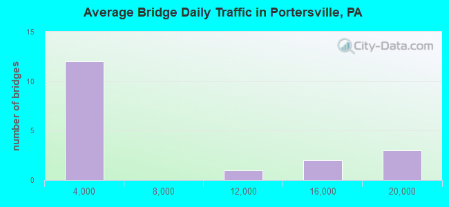
- 94,430Total average daily traffic
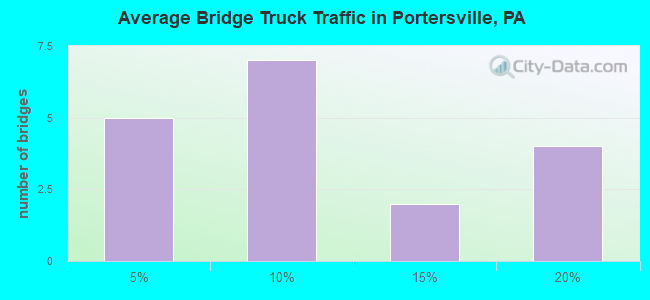
- 13,838Total average daily truck traffic
- National Bridge Inventory (NBI) Registered Bridges for Portersville
- No street view available for this location
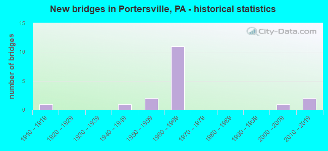
- New bridges - historical statistics
- 11910-1919
- 11940-1949
- 21950-1959
- 111960-1969
- 12000-2009
- 22010-2019
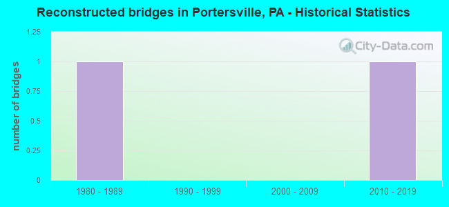
- Reconstructed bridges - Historical Statistics
- 11980-1989
- 01990-1999
- 02000-2009
- 12010-2019

- Bridge Condition - Deck
- 22.2%Very good
- 11.1%Good
- 22.2%Satisfactory
- 11.1%Fair
- 33.3%Poor
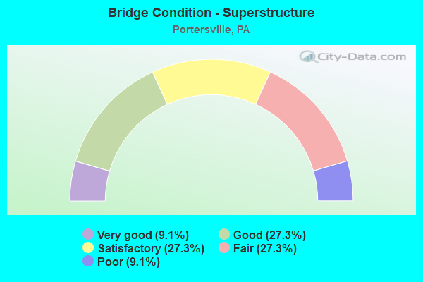
- Bridge Condition - Superstructure
- 9.1%Very good
- 27.3%Good
- 27.3%Satisfactory
- 27.3%Fair
- 9.1%Poor
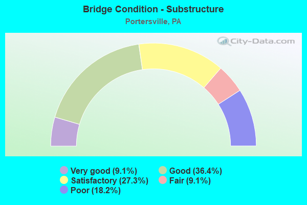
- Bridge Condition - Substructure
- 9.1%Very good
- 36.4%Good
- 27.3%Satisfactory
- 9.1%Fair
- 18.2%Poor
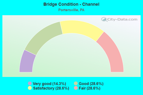
- Bridge Condition - Channel
- 14.3%Very good
- 28.6%Good
- 28.6%Satisfactory
- 28.6%Fair
Find on map >> Show street view
Structure Number: 7874, Location: SAWYER RD NB (Lat: 40.887675, Lng: -80.117664), Route carried "on" structure: State highway , Year Built: 1963, Status: Open, Structure Length: 4.36m (14.30ft), Average Daily Traffic: 163 (year 2022), Truck Traffic: 8%, Average Future Daily Traffic: 266 (year 2032), Design Load: HS 20, Features Intersected: SR0079 NB, Facility Carried by Structure: SR3042 (T-357)
Minimum Vertical Clearance: 30+ m (98+ ft), Kilometerpoint: 0.043, Lanes on structure: 2, Lanes under structure: 2, Owner: State Highway Agency, Approaching Roadway Width: 5.5m (18.0ft), Skew: 1 degrees, Material/Design: Prestressed concrete, Design/Construction: Box Beam or Girders - Single/Spread, Number Of Spans In Main Unit: 3, Length of Maximum Span: 17.7m (58.1ft), Curb or Sidewalk Widths: Left: 0.5m (1.6ft), Right: 0.5m (1.6ft), Curb-To-Curb Width: 8.6m (28.2ft), Out-to-Out Width: 10.1m (33.1ft)
Condition: Deck: Poor, Superstructure: Good, Substructure: Satisfactory, Operating Rating: 39.9 metric tons, Method Used To Determine Operating Rating: Load Factor (LF), Inventory Rating: 23.6 metric tons, Method Used To Determine Inventory Rating: Load Factor (LF), Structural Evaluation: Equal to present minimum criteria, Deck Geometry: Equal to present minimum criteria, Underclear: Equal to present minimum criteria, Approach Roadway Alignment: Equal to present desirable criteria, Length Of Structure Improvement: 5.30m (17.39ft), Designated Inspection Frequency: Every 24 months, Inspection Date: August 2020, Deck Structure Type: Concrete Cast-file-Place, Wearing Surface/Protective System: Wearing Surface: Monolithic Concrete
Find on map >> Show street view
Structure Number: 7875, Location: SAWYER RD SB (Lat: 40.887628, Lng: -80.119114), Route carried "on" structure: State highway , Year Built: 1963, Status: Open, Structure Length: 4.36m (14.30ft), Average Daily Traffic: 163 (year 2022), Truck Traffic: 8%, Average Future Daily Traffic: 266 (year 2032), Design Load: HS 20, Features Intersected: SR0079 SB, Facility Carried by Structure: SR3042 (T-357)
Minimum Vertical Clearance: 30+ m (98+ ft), Kilometerpoint: 0.000, Lanes on structure: 2, Lanes under structure: 2, Owner: State Highway Agency, Approaching Roadway Width: 5.5m (18.0ft), Skew: 2 degrees, Material/Design: Prestressed concrete, Design/Construction: Box Beam or Girders - Single/Spread, Number Of Spans In Main Unit: 3, Length of Maximum Span: 18.6m (61.0ft), Curb or Sidewalk Widths: Left: 0.5m (1.6ft), Right: 0.5m (1.6ft), Curb-To-Curb Width: 8.6m (28.2ft), Out-to-Out Width: 10.1m (33.1ft)
Condition: Deck: Poor, Superstructure: Satisfactory, Substructure: Good, Operating Rating: 46.3 metric tons, Method Used To Determine Operating Rating: Load Factor (LF), Inventory Rating: 27.2 metric tons, Method Used To Determine Inventory Rating: Load Factor (LF), Structural Evaluation: Equal to present minimum criteria, Deck Geometry: Equal to present minimum criteria, Underclear: Somewhat better than minimum adequacy, Approach Roadway Alignment: Equal to present desirable criteria, Length Of Structure Improvement: 5.30m (17.39ft), Designated Inspection Frequency: Every 24 months, Inspection Date: August 2020, Deck Structure Type: Concrete Cast-file-Place, Wearing Surface/Protective System: Wearing Surface: Monolithic Concrete
Find on map >> Show street view
Structure Number: 7876, Location: PFEIFER NB (Lat: 40.908244, Lng: -80.124214), Route carried "on" structure: Interstate 79, Year Built: 1963, Year Reconstructed: 1993, Status: Open, Structure Length: 3.41m (11.19ft), Average Daily Traffic: 15,515 (year 2021), Truck Traffic: 16%, Average Future Daily Traffic: 14,990 (year 2032), Design Load: HS 20+Mod, Features Intersected: T-370 STANFORD RD
Minimum Vertical Clearance: 30+ m (98+ ft), Kilometerpoint: 28.075, Lanes on structure: 2, Lanes under structure: 2, Base Highway Network: Yes, Owner: State Highway Agency, Approaching Roadway Width: 11.6m (38.1ft), Skew: 10 degrees, Material/Design: Prestressed concrete, Design/Construction: Box Beam or Girders - Single/Spread, Number Of Spans In Main Unit: 3, Length of Maximum Span: 11.0m (36.1ft), Curb or Sidewalk Widths: Left: 0.2m (0.7ft), Right: 0.2m (0.7ft), Curb-To-Curb Width: 12.6m (41.3ft), Out-to-Out Width: 13.9m (45.6ft)
Condition: Deck: Satisfactory, Superstructure: Satisfactory, Substructure: Satisfactory, Operating Rating: 74.4 metric tons, Method Used To Determine Operating Rating: Load Factor (LF), Inventory Rating: 41.7 metric tons, Method Used To Determine Inventory Rating: Load Factor (LF), Structural Evaluation: Equal to present minimum criteria, Deck Geometry: Better than present minimum criteria, Underclear: Meets minimum limits, Approach Roadway Alignment: Equal to present desirable criteria, Length Of Structure Improvement: 3.90m (12.80ft), Designated Inspection Frequency: Every 24 months, Inspection Date: Febuary 2021, Bridge Improvement Cost: $26,000, Roadway Improvement Cost: $77,000, Total Project Cost: $353,000, Deck Structure Type: Concrete Cast-file-Place, Wearing Surface/Protective System: Wearing Surface: Bituminous
Find on map >> Show street view
Structure Number: 7945, Location: SOUTH OF LAKE ARTHUR (Lat: 40.935636, Lng: -80.104133), Route carried "on" structure: US 422, Year Built: 1969, Status: Open, Structure Length: 3.29m (10.79ft), Average Daily Traffic: 11,266 (year 2022), Truck Traffic: 15%, Average Future Daily Traffic: 9,932 (year 2032), Design Load: HS 20, Features Intersected: SR 4005
Minimum Vertical Clearance: 30+ m (98+ ft), Kilometerpoint: 6.777, Lanes on structure: 4, Lanes under structure: 2, Base Highway Network: Yes, Owner: State Highway Agency, Approaching Roadway Width: 23.2m (76.1ft), Skew: 21 degrees, Material/Design: Prestressed concrete, Design/Construction: Box Beam or Girders - Single/Spread, Number Of Spans In Main Unit: 3, Length of Maximum Span: 13.4m (44.0ft), Curb or Sidewalk Widths: Left: 0.2m (0.7ft), Right: 0.2m (0.7ft), Curb-To-Curb Width: 29.9m (98.1ft), Out-to-Out Width: 31.5m (103.3ft)
Condition: Deck: Satisfactory, Superstructure: Fair, Substructure: Satisfactory, Operating Rating: 55.3 metric tons, Method Used To Determine Operating Rating: Load Factor (LF), Inventory Rating: 22.7 metric tons, Method Used To Determine Inventory Rating: Load Factor (LF), Structural Evaluation: Somewhat better than minimum adequacy, Deck Geometry: Superior to present desirable criteria, Underclear: Equal to present minimum criteria, Approach Roadway Alignment: Equal to present desirable criteria, Length Of Structure Improvement: 4.11m (13.48ft), Designated Inspection Frequency: Every 24 months, Inspection Date: April 2020, Bridge Improvement Cost: $61,000, Roadway Improvement Cost: $181,000, Total Project Cost: $828,000, Deck Structure Type: Concrete Cast-file-Place, Wearing Surface/Protective System: Wearing Surface: Bituminous, Membrane: Preformed Fabric
Find on map >> Show street view
Structure Number: 2242, Location: ECKERT BR, MC MILL PARK (Lat: 40.940600, Lng: -80.176597), Route carried "on" structure: State highway , Year Built: 1954, Status: Open, Structure Length: 4.39m (14.40ft), Average Daily Traffic: 62 (year 2014), Truck Traffic: 9%, Average Future Daily Traffic: 42 (year 2032), Design Load: HS 20, Features Intersected: SLIPPERY ROCK CREEK, Facility Carried by Structure: MCCONNELL ROAD
Minimum Vertical Clearance: 30+ m (98+ ft), Kilometerpoint: 0.950, Lanes on structure: 2, Owner: State Park, Forest, or Reservation Agency, Approaching Roadway Width: 9.1m (29.9ft), Material/Design: Steel, Design/Construction: Stringer/Multi-beam, Number Of Spans In Main Unit: 2, Length of Maximum Span: 21.3m (69.9ft), Curb-To-Curb Width: 8.5m (27.9ft), Out-to-Out Width: 9.4m (30.8ft)
Condition: Deck: Poor, Superstructure: Fair, Substructure: Poor, Channel: Fair, Operating Rating: 84.4 metric tons, Method Used To Determine Operating Rating: Load Factor (LF), Inventory Rating: 50.8 metric tons, Method Used To Determine Inventory Rating: Load Factor (LF), Structural Evaluation: Meets minimum limits, Deck Geometry: Better than present minimum criteria, Waterway Adequacy: Superior to present desirable criteria, Approach Roadway Alignment: High priority of corrective action, Length Of Structure Improvement: 4.40m (14.44ft), Designated Inspection Frequency: Every 24 months, Inspection Date: July 2020, Bridge Improvement Cost: $34,000, Roadway Improvement Cost: $100,000, Total Project Cost: $458,000, Deck Structure Type: Concrete Cast-file-Place, Wearing Surface/Protective System: Wearing Surface: Monolithic Concrete
Find on map >> Show street view
Structure Number: 22431, Location: 1700' N.E. OF SR 2022 (Lat: 40.912083, Lng: -80.216897), Route carried "on" structure: State highway , Year Built: 1940, Year Reconstructed: 2018, Status: Open, Structure Length: 5.82m (19.09ft), Average Daily Traffic: 149 (year 2020), Truck Traffic: 2%, Average Future Daily Traffic: 127 (year 2032), Design Load: HS 20, Features Intersected: SLIPPERY ROCK CREEK, Facility Carried by Structure: MOUNTVILLE RD
Minimum Vertical Clearance: 4.29m (14.07ft), Kilometerpoint: 0.000, Lanes on structure: 2, Owner: State Highway Agency, Approaching Roadway Width: 6.1m (20.0ft), Skew: 4 degrees, Material/Design: Steel, Design/Construction: Truss - Thru, Number Of Spans In Main Unit: 1, Length of Maximum Span: 56.7m (186.0ft), Curb-To-Curb Width: 7.3m (24.0ft), Out-to-Out Width: 7.9m (25.9ft)
Condition: Deck: Very good, Superstructure: Satisfactory, Substructure: Good, Channel: Very good, Operating Rating: 43.5 metric tons, Method Used To Determine Operating Rating: Load Factor (LF), Inventory Rating: 25.4 metric tons, Method Used To Determine Inventory Rating: Load Factor (LF), Structural Evaluation: Equal to present minimum criteria, Deck Geometry: Meets minimum limits, Waterway Adequacy: Superior to present desirable criteria, Approach Roadway Alignment: Equal to present minimum criteria, Length Of Structure Improvement: 5.80m (19.03ft), Designated Inspection Frequency: Every 24 months, Critical Feature Inspection Frequency: Every 24 months, Inspection Date: June 2020, Critical Feature Inspection Date: June 2020, Bridge Improvement Cost: $67,000, Roadway Improvement Cost: $197,000, Total Project Cost: $905,000, Deck Structure Type: Concrete Cast-file-Place, Wearing Surface/Protective System: Wearing Surface: Monolithic Concrete, Deck Protection: Epoxy Coated Reinforcing
Find on map >> Show street view
Structure Number: 22542, Location: 207003 BARKLEY RD (Lat: 40.883536, Lng: -80.175569), Route carried "on" structure: City street 353, Year Built: 1950, Status: Posted for load, Structure Length: 0.98m (3.22ft), Average Daily Traffic: 100 (year 2016), Truck Traffic: 4%, Average Future Daily Traffic: 150 (year 2036), Design Load: HS 20, Features Intersected: CAMP RUN, Facility Carried by Structure: BARKLEY RD #3
Minimum Vertical Clearance: 30+ m (98+ ft), Kilometerpoint: 0.000, Lanes on structure: 2, Owner: Town or Township Highway Agency, Approaching Roadway Width: 3.7m (12.1ft), Material/Design: Steel, Design/Construction: Stringer/Multi-beam, Number Of Spans In Main Unit: 1, Length of Maximum Span: 9.1m (29.9ft), Curb-To-Curb Width: 4.5m (14.8ft), Out-to-Out Width: 4.9m (16.1ft)
Condition: Deck: Fair, Superstructure: Poor, Substructure: Poor, Channel: Satisfactory, Operating Rating: 13.6 metric tons, Method Used To Determine Operating Rating: Load Factor (LF), Inventory Rating: 8.2 metric tons, Method Used To Determine Inventory Rating: Load Factor (LF), Structural Evaluation: High priority of replacement, Deck Geometry: High priority of replacement, Waterway Adequacy: Equal to present minimum criteria, Approach Roadway Alignment: Equal to present desirable criteria, Bridge Posting: Required (Relationship of Operating Rating to Maximum Legal Load: > 39.9% below), Length Of Structure Improvement: 1.00m (3.28ft), Designated Inspection Frequency: Every 24 months, Other Special Inspection Frequency: Every 12 months, Inspection Date: April 2020, Other Special Inspection Date: April 2021, Bridge Improvement Cost: $15,000, Roadway Improvement Cost: $44,000, Total Project Cost: $203,000, Deck Structure Type: Concrete Cast-file-Place, Wearing Surface/Protective System: Wearing Surface: Bituminous
Find on map >> Show street view
Structure Number: 22543, Location: 207001 NEAR T-353 (Lat: 40.897161, Lng: -80.169686), Route carried "on" structure: City street , Year Built: 1913, Status: Open, Structure Length: 0.91m (2.99ft), Average Daily Traffic: 50 (year 2014), Truck Traffic: 5%, Average Future Daily Traffic: 100 (year 2034), Features Intersected: CAMP RUN, Facility Carried by Structure: MCKEE RD-BARKLEY#1
Minimum Vertical Clearance: 30+ m (98+ ft), Kilometerpoint: 0.000, Lanes on structure: 2, Owner: Town or Township Highway Agency, Approaching Roadway Width: 4.3m (14.1ft), Material/Design: Concrete, Design/Construction: Arch - Deck, Number Of Spans In Main Unit: 1, Length of Maximum Span: 9.1m (29.9ft), Curb-To-Curb Width: 4.6m (15.1ft), Out-to-Out Width: 5.5m (18.0ft)
Condition: Superstructure: Fair, Substructure: Fair, Channel: Fair, Operating Rating: 73.5 metric tons, Method Used To Determine Operating Rating: Field evaluation and documented engineering judgment, Inventory Rating: 43.5 metric tons, Method Used To Determine Inventory Rating: Field evaluation and documented engineering judgment, Structural Evaluation: Somewhat better than minimum adequacy, Deck Geometry: High priority of replacement, Waterway Adequacy: Equal to present desirable criteria, Approach Roadway Alignment: Equal to present desirable criteria, Length Of Structure Improvement: 1.60m (5.25ft), Designated Inspection Frequency: Every 24 months, Inspection Date: April 2020, Bridge Improvement Cost: $25,000, Roadway Improvement Cost: $74,000, Total Project Cost: $338,000
Find on map >> Show street view
Structure Number: 44183, Location: BTW SR0019 & T353 (Lat: 40.879133, Lng: -80.126889), Route carried "on" structure: City street , Year Built: 2005, Status: Open, Structure Length: 1.16m (3.81ft), Average Daily Traffic: 100 (year 2015), Truck Traffic: 9%, Average Future Daily Traffic: 120 (year 2035), Design Load: HL 93, Features Intersected: LITTLE YELLOW CREEK, Facility Carried by Structure: T-338, PFEIFER RD
Minimum Vertical Clearance: 30+ m (98+ ft), Kilometerpoint: 0.000, Lanes on structure: 2, Owner: County Highway Agency, Approaching Roadway Width: 6.1m (20.0ft), Material/Design: Steel, Design/Construction: Stringer/Multi-beam, Number Of Spans In Main Unit: 1, Length of Maximum Span: 11.0m (36.1ft), Curb-To-Curb Width: 7.3m (24.0ft), Out-to-Out Width: 7.6m (24.9ft)
Condition: Deck: Good, Superstructure: Good, Substructure: Good, Channel: Satisfactory, Operating Rating: 98.9 metric tons, Method Used To Determine Operating Rating: Load Factor (LF), Inventory Rating: 59.0 metric tons, Method Used To Determine Inventory Rating: Load Factor (LF), Structural Evaluation: Better than present minimum criteria, Deck Geometry: Equal to present minimum criteria, Waterway Adequacy: Better than present minimum criteria, Approach Roadway Alignment: Equal to present minimum criteria, Designated Inspection Frequency: Every 24 months, Inspection Date: July 2021, Deck Structure Type: Concrete Cast-file-Place, Wearing Surface/Protective System: Wearing Surface: Monolithic Concrete, Deck Protection: Epoxy Coated Reinforcing
Find on map >> Show street view
Structure Number: 54294, Location: 435' NW of SR 2011 (Lat: 40.875253, Lng: -80.176608), Route carried "on" structure: State highway , Year Built: 2017, Status: Open, Structure Length: 1.49m (4.89ft), Average Daily Traffic: 401 (year 2020), Truck Traffic: 3%, Average Future Daily Traffic: 600 (year 2035), Design Load: HL 93, Features Intersected: Camp Run, Facility Carried by Structure: Pleasant Road
Minimum Vertical Clearance: 30+ m (98+ ft), Kilometerpoint: 2.134, Lanes on structure: 2, Owner: State Highway Agency, Approaching Roadway Width: 7.3m (24.0ft), Skew: 3 degrees, Material/Design: Prestressed concrete, Design/Construction: Box Beam or Girders - Single/Spread, Number Of Spans In Main Unit: 1, Length of Maximum Span: 14.3m (46.9ft), Curb or Sidewalk Widths: Left: 0.2m (0.7ft), Right: 0.2m (0.7ft), Curb-To-Curb Width: 7.3m (24.0ft), Out-to-Out Width: 8.3m (27.2ft)
Condition: Deck: Very good, Superstructure: Very good, Substructure: Very good, Channel: Good, Operating Rating: 45.4 metric tons, Method Used To Determine Operating Rating: Assigned ratings based on Load and Resistance Factor Design (LRFD) reported by rating factor (RF) using HL93 loadings, Inventory Rating: 35.0 metric tons, Method Used To Determine Inventory Rating: Assigned ratings based on Load and Resistance Factor Design (LRFD) reported by rating factor (RF) using HL93 loadings, Structural Evaluation: Equal to present desirable criteria, Deck Geometry: Meets minimum limits, Waterway Adequacy: Equal to present desirable criteria, Approach Roadway Alignment: Equal to present desirable criteria, Designated Inspection Frequency: Every 24 months, Inspection Date: October 2019, Deck Structure Type: Concrete Cast-file-Place, Wearing Surface/Protective System: Wearing Surface: Monolithic Concrete, Deck Protection: Epoxy Coated Reinforcing
Find on map >> Show street view
Structure Number: 54363, Location: 400' E of T-522 (Lat: 40.892025, Lng: -80.171797), Route carried "on" structure: City street 353, Year Built: 2018, Status: Open, Structure Length: 0.98m (3.22ft), Average Daily Traffic: 50 (year 2018), Truck Traffic: 5%, Average Future Daily Traffic: 60 (year 2038), Design Load: HL 93, Features Intersected: Camp Run, Facility Carried by Structure: Barkley Road
Minimum Vertical Clearance: 30+ m (98+ ft), Kilometerpoint: 0.000, Lanes on structure: 2, Owner: Town or Township Highway Agency, Approaching Roadway Width: 6.7m (22.0ft), Material/Design: Concrete, Design/Construction: Arch - Deck, Number Of Spans In Main Unit: 1, Length of Maximum Span: 9.8m (32.2ft), Curb-To-Curb Width: 6.9m (22.6ft), Out-to-Out Width: 8.0m (26.2ft)
Condition: Superstructure: Good, Substructure: Good, Channel: Good, Operating Rating: 48.6 metric tons, Method Used To Determine Operating Rating: Assigned ratings based on Load and Resistance Factor Design (LRFD) reported by rating factor (RF) using HL93 loadings, Inventory Rating: 32.4 metric tons, Method Used To Determine Inventory Rating: Assigned ratings based on Load and Resistance Factor Design (LRFD) reported by rating factor (RF) using HL93 loadings, Structural Evaluation: Better than present minimum criteria, Deck Geometry: Somewhat better than minimum adequacy, Waterway Adequacy: Superior to present desirable criteria, Approach Roadway Alignment: Equal to present desirable criteria, Designated Inspection Frequency: Every 24 months, Inspection Date: April 2021
Find on map >> Show street view
Structure Number: 7874, Location: SAWYER RD NB (Lat: 40.887675, Lng: -80.117664), Route carried "under" structure: Interstate 79, Year Built: 1963, Structure Length: 0. m, Average Daily Traffic: 15,515 (year 2021), Truck Traffic: 16%, Features Intersected: SR0079 NB, Facility Carried by Structure: SR3042 (T-357)
Minimum Vertical Clearance: 5.24m (17.19ft), Kilometerpoint: 25.701, Lanes on structure: 2, Lanes under structure: 2, Material/Design: Prestressed concrete, Design/Construction: Box Beam or Girders - Single/Spread, Length of Maximum Span: 17.7m (58.1ft)
Find on map >> Show street view
Structure Number: 7875, Location: SAWYER RD SB (Lat: 40.887628, Lng: -80.119114), Route carried "under" structure: Interstate 79, Year Built: 1963, Structure Length: 0. m, Average Daily Traffic: 16,252 (year 2021), Truck Traffic: 16%, Features Intersected: SR0079 SB, Facility Carried by Structure: SR3042 (T-357)
Minimum Vertical Clearance: 4.89m (16.04ft), Kilometerpoint: 25.687, Lanes on structure: 2, Lanes under structure: 2, Material/Design: Prestressed concrete, Design/Construction: Box Beam or Girders - Single/Spread, Length of Maximum Span: 18.6m (61.0ft)
Find on map >> Show street view
Structure Number: 7876, Location: PFEIFER NB (Lat: 40.908244, Lng: -80.124214), Route carried "under" structure: City street 3042, Year Built: 1963, Structure Length: 0. m, Average Daily Traffic: 100 (year 2005), Truck Traffic: 5%, Features Intersected: T-370 STANFORD RD, Facility Carried by Structure: SR0079 NB
Minimum Vertical Clearance: 5.03m (16.50ft), Kilometerpoint: 0.000, Lanes on structure: 2, Lanes under structure: 2, Material/Design: Prestressed concrete, Design/Construction: Box Beam or Girders - Single/Spread, Length of Maximum Span: 11.0m (36.1ft)
Find on map >> Show street view
Structure Number: 7878, Location: PFEIFER SB (Lat: 40.908153, Lng: -80.124517), Route carried "under" structure: City street 338, Year Built: 1963, Structure Length: 0. m, Average Daily Traffic: 100 (year 2002), Truck Traffic: 1%, Features Intersected: T-370 STANFORD RD, Facility Carried by Structure: SR0079 SB
Minimum Vertical Clearance: 4.42m (14.50ft), Kilometerpoint: 0.000, Lanes on structure: 2, Lanes under structure: 2, Material/Design: Prestressed concrete, Design/Construction: Box Beam or Girders - Single/Spread, Length of Maximum Span: 11.0m (36.1ft)
Find on map >> Show street view
Structure Number: 7945, Location: SOUTH OF LAKE ARTHUR (Lat: 40.935636, Lng: -80.104133), Route carried "under" structure: State highway , Year Built: 1969, Structure Length: 0. m, Average Daily Traffic: 1,218 (year 2022), Truck Traffic: 3%, Features Intersected: SR 4005, Facility Carried by Structure: SR 0422
Minimum Vertical Clearance: 4.58m (15.03ft), Kilometerpoint: 1.053, Lanes on structure: 4, Lanes under structure: 2, Material/Design: Prestressed concrete, Design/Construction: Box Beam or Girders - Single/Spread, Length of Maximum Span: 13.4m (44.0ft)
Find on map >> Show street view
Structure Number: 797, Location: PORTERSVILLE (Lat: 40.921783, Lng: -80.133039), Route carried "under" structure: Interstate 79, Year Built: 1965, Structure Length: 0. m, Average Daily Traffic: 16,201 (year 2021), Truck Traffic: 14%, Features Intersected: I-79 NB&SB, Facility Carried by Structure: SR 0488
Minimum Vertical Clearance: 5.15m (16.90ft), Kilometerpoint: 29.691, Lanes on structure: 2, Lanes under structure: 2, Material/Design: Prestressed concrete, Design/Construction: Box Beam or Girders - Single/Spread, Length of Maximum Span: 20.4m (66.9ft)
Find on map >> Show street view
Structure Number: 797, Location: PORTERSVILLE (Lat: 40.921783, Lng: -80.133039), Route carried "under" structure: Interstate 79, Year Built: 1965, Structure Length: 0. m, Average Daily Traffic: 17,025 (year 2021), Truck Traffic: 13%, Features Intersected: I-79 NB&SB, Facility Carried by Structure: SR 0488
Minimum Vertical Clearance: 4.98m (16.34ft), Kilometerpoint: 29.675, Lanes on structure: 2, Lanes under structure: 3, Material/Design: Prestressed concrete, Design/Construction: Box Beam or Girders - Single/Spread, Length of Maximum Span: 20.4m (66.9ft)