Bridge Statistics for Portland, Texas (TX)
Condition, Traffic, Stress, Structural Evaluation, Project Costs
- National Bridge Inventory (NBI) Statistics
- 19Number of bridges
- 1,230ft / 375mTotal length
- $26,000Total costs
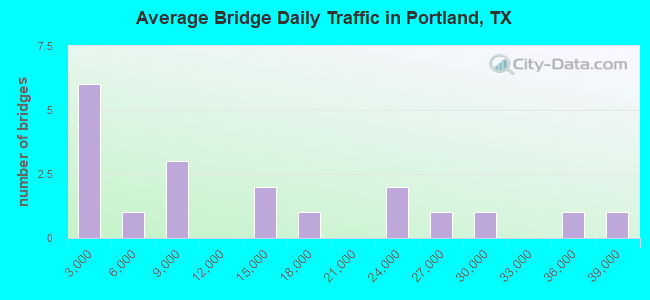
- 243,687Total average daily traffic
- 16,866Total average daily truck traffic
- National Bridge Inventory (NBI) Registered Bridges for Portland
- No street view available for this location
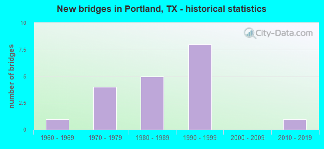
- New bridges - historical statistics
- 11960-1969
- 41970-1979
- 51980-1989
- 81990-1999
- 12010-2019
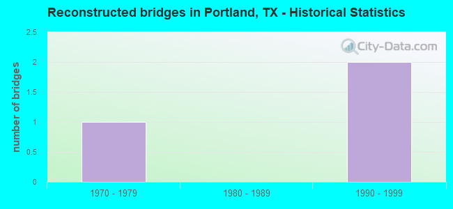
- Reconstructed bridges - Historical Statistics
- 11970-1979
- 01980-1989
- 21990-1999
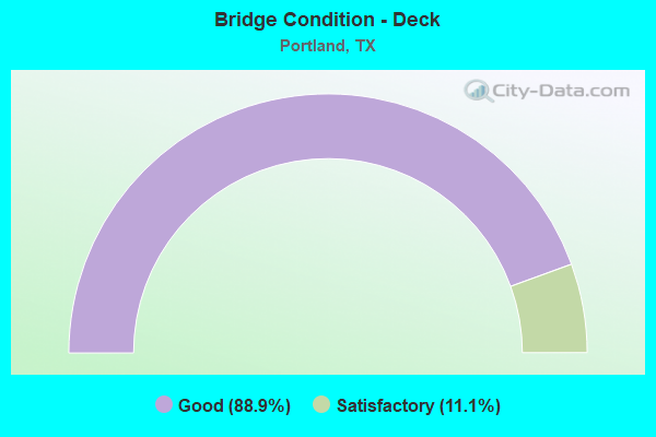
- Bridge Condition - Deck
- 88.9%Good
- 11.1%Satisfactory
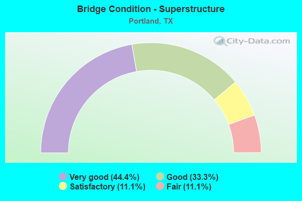
- Bridge Condition - Superstructure
- 44.4%Very good
- 33.3%Good
- 11.1%Satisfactory
- 11.1%Fair
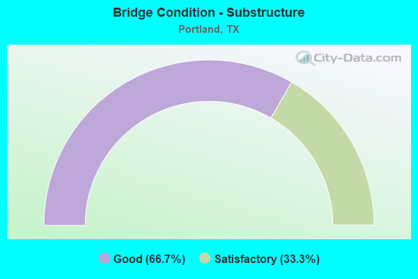
- Bridge Condition - Substructure
- 66.7%Good
- 33.3%Satisfactory
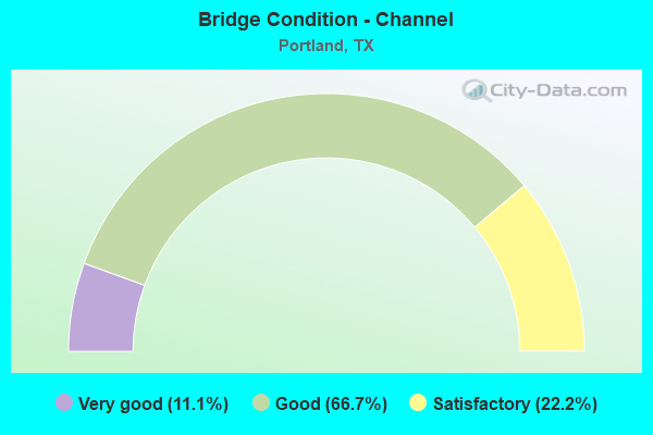
- Bridge Condition - Channel
- 11.1%Very good
- 66.7%Good
- 22.2%Satisfactory
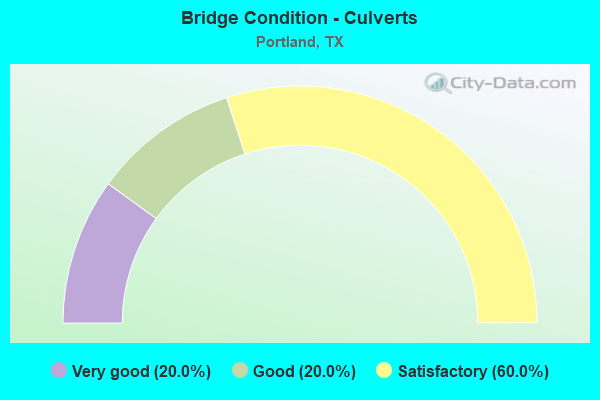
- Bridge Condition - Culverts
- 20.0%Very good
- 20.0%Good
- 60.0%Satisfactory
Find on map >> Show street view
Structure Number: 161780010106063, Location: 2.3 MI NE OF SHIP CHANNEL (Lat: 27.853025, Lng: -97.358183), Route carried "on" structure: US 181, Year Built: 1963, Year Reconstructed: 1990, Status: Open, Structure Length: 293.74m (963.71ft), Average Daily Traffic: 28,117 (year 2019), Truck Traffic: 6%, Average Future Daily Traffic: 34,480 (year 2033), Design Load: H 20, Features Intersected: NUECES BAY
Minimum Vertical Clearance: 30+ m (98+ ft), Kilometerpoint: 0.002, Lanes on structure: 3, Owner: State Highway Agency, Approaching Roadway Width: 17.1m (56.1ft), Navigation Control: Yes ( Vertical Clearance: 15.2m (49.9ft), Horizontal Clearance: 22.9m (75.1ft)), Material/Design: Prestressed concrete, Design/Construction: Stringer/Multi-beam, Number Of Spans In Main Unit: 1, Number Of Approach Spans: 165, Length of Maximum Span: 33.5m (109.9ft), Curb-To-Curb Width: 16.8m (55.1ft), Out-to-Out Width: 17.7m (58.1ft)
Condition: Deck: Satisfactory, Superstructure: Fair, Substructure: Satisfactory, Channel: Good, Operating Rating: 64.4 metric tons, Method Used To Determine Operating Rating: Load Factor (LF), Inventory Rating: 34.5 metric tons, Method Used To Determine Inventory Rating: Load Factor (LF), Structural Evaluation: Somewhat better than minimum adequacy, Deck Geometry: Equal to present minimum criteria, Waterway Adequacy: Equal to present desirable criteria, Approach Roadway Alignment: Equal to present desirable criteria, Designated Inspection Frequency: Every 24 months, Underwater Inspection Frequency: Every 60 months, Inspection Date: August 2020, Underwater Inspection Date: August 2019, Deck Structure Type: Concrete Cast-file-Place
Find on map >> Show street view
Structure Number: 16205001010404, Location: 0.45 MI NE OF FM 893 (Lat: 27.881000, Lng: -97.319169), Route carried "on" structure: US 181, Year Built: 1971, Year Reconstructed: 2002, Status: Open, Structure Length: 26.21m (85.99ft), Average Daily Traffic: 22,390 (year 2013), Truck Traffic: 7%, Average Future Daily Traffic: 31,350 (year 2033), Design Load: HS 20, Features Intersected: FM 2986 (WILDCAT DR)
Minimum Vertical Clearance: 30+ m (98+ ft), Kilometerpoint: 42.772, Lanes on structure: 3, Lanes under structure: 7, Base Highway Network: Yes, Owner: State Highway Agency, Approaching Roadway Width: 18.3m (60.0ft), Skew: 9 degrees, Material/Design: Prestressed concrete, Design/Construction: Stringer/Multi-beam, Number Of Spans In Main Unit: 7, Number Of Approach Spans: 3, Length of Maximum Span: 36.3m (119.1ft), Curb or Sidewalk Widths: Left: 0.0m, Right: 2.9m (9.5ft), Curb-To-Curb Width: 18.0m (59.1ft), Out-to-Out Width: 22.6m (74.1ft)
Condition: Deck: Good, Superstructure: Satisfactory, Substructure: Good, Operating Rating: 68.0 metric tons, Method Used To Determine Operating Rating: Load Factor (LF), Inventory Rating: 29.9 metric tons, Method Used To Determine Inventory Rating: Load Factor (LF), Structural Evaluation: Equal to present minimum criteria, Deck Geometry: Better than present minimum criteria, Underclear: Somewhat better than minimum adequacy, Approach Roadway Alignment: Equal to present desirable criteria, Designated Inspection Frequency: Every 24 months, Inspection Date: June 2020, Deck Structure Type: Concrete Cast-file-Place
Find on map >> Show street view
Structure Number: 16205001010406, Location: 1.3 MI NE OF FM 2986 (Lat: 27.897381, Lng: -97.307669), Route carried "on" structure: US 181, Year Built: 1987, Status: Open, Structure Length: 7.92m (25.98ft), Average Daily Traffic: 17,141 (year 2019), Truck Traffic: 7%, Average Future Daily Traffic: 31,350 (year 2033), Design Load: HS 20, Features Intersected: FM 3239 (BUDDY GANEM DR)
Minimum Vertical Clearance: 30+ m (98+ ft), Kilometerpoint: 40.689, Lanes on structure: 2, Lanes under structure: 8, Base Highway Network: Yes, Owner: State Highway Agency, Approaching Roadway Width: 11.6m (38.1ft), Material/Design: Prestressed concrete, Design/Construction: Stringer/Multi-beam, Number Of Spans In Main Unit: 3, Length of Maximum Span: 30.5m (100.1ft), Curb-To-Curb Width: 11.3m (37.1ft), Out-to-Out Width: 12.2m (40.0ft)
Condition: Deck: Good, Superstructure: Good, Substructure: Good, Operating Rating: 54.4 metric tons, Method Used To Determine Operating Rating: Assigned rating based on Load Factor Design (LFD) reported in metric tons, Inventory Rating: 32.7 metric tons, Method Used To Determine Inventory Rating: Assigned rating based on Load Factor Design (LFD) reported in metric tons, Structural Evaluation: Better than present minimum criteria, Deck Geometry: Somewhat better than minimum adequacy, Underclear: Meets minimum limits, Approach Roadway Alignment: Equal to present desirable criteria, Designated Inspection Frequency: Every 24 months, Inspection Date: April 2020, Deck Structure Type: Concrete Precast Panels, Wearing Surface/Protective System: Wearing Surface: Bituminous
Find on map >> Show street view
Structure Number: 162050010104061, Location: 1.3 MI NE OF FM 2986 (Lat: 27.897292, Lng: -97.307494), Route carried "on" structure: US 181, Year Built: 1987, Status: Open, Structure Length: 7.92m (25.98ft), Average Daily Traffic: 24,117 (year 2019), Truck Traffic: 7%, Average Future Daily Traffic: 31,350 (year 2033), Design Load: HS 20, Features Intersected: FM 3239 (BUDDY GANEM DR)
Minimum Vertical Clearance: 30+ m (98+ ft), Kilometerpoint: 40.689, Lanes on structure: 2, Lanes under structure: 8, Base Highway Network: Yes, Owner: State Highway Agency, Approaching Roadway Width: 11.6m (38.1ft), Material/Design: Prestressed concrete, Design/Construction: Stringer/Multi-beam, Number Of Spans In Main Unit: 3, Length of Maximum Span: 30.5m (100.1ft), Curb-To-Curb Width: 11.3m (37.1ft), Out-to-Out Width: 12.2m (40.0ft)
Condition: Deck: Good, Superstructure: Good, Substructure: Satisfactory, Operating Rating: 54.4 metric tons, Method Used To Determine Operating Rating: Assigned rating based on Load Factor Design (LFD) reported in metric tons, Inventory Rating: 32.7 metric tons, Method Used To Determine Inventory Rating: Assigned rating based on Load Factor Design (LFD) reported in metric tons, Structural Evaluation: Equal to present minimum criteria, Deck Geometry: Somewhat better than minimum adequacy, Underclear: Meets minimum limits, Approach Roadway Alignment: Equal to present desirable criteria, Designated Inspection Frequency: Every 24 months, Inspection Date: April 2020, Deck Structure Type: Concrete Precast Panels, Wearing Surface/Protective System: Wearing Surface: Bituminous
Find on map >> Show street view
Structure Number: 162050010104062, Location: 0.03 MI N OF FM 3239 (Lat: 27.897006, Lng: -97.306942), Route carried "on" structure: US 181, Year Built: 1987, Status: Open, Structure Length: 1.13m (3.71ft), Average Daily Traffic: 35,482 (year 2020), Truck Traffic: 7%, Average Future Daily Traffic: 62,700 (year 2033), Design Load: HS 20, Features Intersected: DRAIN
Minimum Vertical Clearance: 30+ m (98+ ft), Kilometerpoint: 40.689, Lanes on structure: 9, Owner: State Highway Agency, Approaching Roadway Width: 45.7m (149.9ft), Material/Design: Concrete, Design/Construction: Culvert, Number Of Spans In Main Unit: 5, Length of Maximum Span: 1.8m (5.9ft)
Condition: Channel: Good, Culverts: Satisfactory, Operating Rating: 39.9 metric tons, Method Used To Determine Operating Rating: Load Factor (LF), Inventory Rating: 23.6 metric tons, Method Used To Determine Inventory Rating: Load Factor (LF), Structural Evaluation: Somewhat better than minimum adequacy, Waterway Adequacy: Equal to present minimum criteria, Approach Roadway Alignment: Equal to present desirable criteria, Designated Inspection Frequency: Every 48 months, Inspection Date: April 2018
Find on map >> Show street view
Structure Number: 162050010104071, Location: 0.50 MI SW OF FM 2986 (Lat: 27.875867, Lng: -97.326556), Route carried "on" structure: State highway 893, Year Built: 1998, Status: Open, Structure Length: 4.69m (15.39ft), Average Daily Traffic: 8,300 (year 2011), Truck Traffic: 5%, Average Future Daily Traffic: 10,530 (year 2031), Design Load: HS 20, Features Intersected: US 181
Minimum Vertical Clearance: 30+ m (98+ ft), Kilometerpoint: 18.221, Lanes on structure: 8, Lanes under structure: 6, Base Highway Network: Yes, Owner: State Highway Agency, Approaching Roadway Width: 20.7m (67.9ft), Material/Design: Prestressed concrete, Design/Construction: Stringer/Multi-beam, Number Of Spans In Main Unit: 2, Length of Maximum Span: 23.5m (77.1ft), Curb or Sidewalk Widths: Left: 2.1m (6.9ft), Right: 2.1m (6.9ft), Curb-To-Curb Width: 34.1m (111.9ft), Out-to-Out Width: 44.5m (146.0ft)
Condition: Deck: Good, Superstructure: Very good, Substructure: Good, Operating Rating: 54.4 metric tons, Method Used To Determine Operating Rating: Assigned rating based on Load Factor Design (LFD) reported in metric tons, Inventory Rating: 32.7 metric tons, Method Used To Determine Inventory Rating: Assigned rating based on Load Factor Design (LFD) reported in metric tons, Structural Evaluation: Better than present minimum criteria, Deck Geometry: Equal to present minimum criteria, Underclear: Equal to present minimum criteria, Approach Roadway Alignment: Equal to present desirable criteria, Designated Inspection Frequency: Every 24 months, Inspection Date: June 2020, Deck Structure Type: Concrete Precast Panels
Find on map >> Show street view
Structure Number: 162050010104072, Location: 0.45 MI NE OF FM 893 (Lat: 27.880044, Lng: -97.320097), Route carried "on" structure: US 181, Year Built: 1999, Status: Open, Structure Length: 26.43m (86.71ft), Average Daily Traffic: 22,390 (year 2013), Truck Traffic: 7%, Average Future Daily Traffic: 31,350 (year 2033), Design Load: HS 20, Features Intersected: FM 2986 (WILDCAT DR)
Minimum Vertical Clearance: 30+ m (98+ ft), Kilometerpoint: 42.772, Lanes on structure: 3, Lanes under structure: 7, Base Highway Network: Yes, Owner: State Highway Agency, Approaching Roadway Width: 17.4m (57.1ft), Skew: 9 degrees, Material/Design: Prestressed concrete, Design/Construction: Stringer/Multi-beam, Number Of Spans In Main Unit: 7, Number Of Approach Spans: 3, Length of Maximum Span: 36.0m (118.1ft), Curb-To-Curb Width: 17.2m (56.4ft), Out-to-Out Width: 18.0m (59.1ft)
Condition: Deck: Good, Superstructure: Very good, Substructure: Good, Operating Rating: 54.4 metric tons, Method Used To Determine Operating Rating: Assigned rating based on Load Factor Design (LFD) reported in metric tons, Inventory Rating: 32.7 metric tons, Method Used To Determine Inventory Rating: Assigned rating based on Load Factor Design (LFD) reported in metric tons, Structural Evaluation: Better than present minimum criteria, Deck Geometry: Better than present minimum criteria, Underclear: Somewhat better than minimum adequacy, Approach Roadway Alignment: Equal to present desirable criteria, Designated Inspection Frequency: Every 24 months, Inspection Date: June 2020, Deck Structure Type: Concrete Cast-file-Place
Find on map >> Show street view
Structure Number: 162050AA0341002, Location: 1.80 MI NW OF FM 2986 (Lat: 27.930600, Lng: -97.339094), Route carried "on" structure: County highway 1612, Year Built: 2011, Status: Open, Structure Length: 0.91m (2.99ft), Average Daily Traffic: 10 (year 2011), Average Future Daily Traffic: 50 (year 2031), Design Load: HL 93, Features Intersected: DRAINAGE DITCH
Minimum Vertical Clearance: 30+ m (98+ ft), Kilometerpoint: 2.897, Lanes on structure: 2, Owner: County Highway Agency, Approaching Roadway Width: 5.8m (19.0ft), Material/Design: Concrete, Design/Construction: Culvert, Number Of Spans In Main Unit: 4, Length of Maximum Span: 1.8m (5.9ft), Curb-To-Curb Width: 7.9m (25.9ft), Out-to-Out Width: 8.5m (27.9ft)
Condition: Channel: Very good, Culverts: Very good, Operating Rating: 54.4 metric tons, Method Used To Determine Operating Rating: Assigned ratings based on Load and Resistance Factor Design (LRFD) reported in metric tons, Inventory Rating: 32.7 metric tons, Method Used To Determine Inventory Rating: Assigned ratings based on Load and Resistance Factor Design (LRFD) reported in metric tons, Structural Evaluation: Equal to present desirable criteria, Deck Geometry: Equal to present minimum criteria, Waterway Adequacy: Better than present minimum criteria, Approach Roadway Alignment: Equal to present desirable criteria, Designated Inspection Frequency: Every 24 months, Inspection Date: June 2021, Deck Structure Type: Concrete Precast Panels, Wearing Surface/Protective System: Wearing Surface: Bituminous
Find on map >> Show street view
Structure Number: 162050AA0352001, Location: 1.85 MI S OF US 181 (Lat: 27.920964, Lng: -97.343494), Route carried "on" structure: County highway 3667, Year Built: 1970, Status: Open, Structure Length: 1.19m (3.90ft), Average Daily Traffic: 160 (year 2011), Average Future Daily Traffic: 200 (year 2031), Features Intersected: DRAIN
Minimum Vertical Clearance: 30+ m (98+ ft), Kilometerpoint: 0.966, Lanes on structure: 2, Owner: County Highway Agency, Approaching Roadway Width: 4.9m (16.1ft), Material/Design: Concrete, Design/Construction: Culvert, Number Of Spans In Main Unit: 6, Length of Maximum Span: 1.8m (5.9ft), Curb-To-Curb Width: 4.9m (16.1ft), Out-to-Out Width: 9.1m (29.9ft)
Condition: Channel: Satisfactory, Culverts: Satisfactory, Operating Rating: 32.7 metric tons, Method Used To Determine Operating Rating: Field evaluation and documented engineering judgment, Inventory Rating: 24.5 metric tons, Method Used To Determine Inventory Rating: Field evaluation and documented engineering judgment, Structural Evaluation: Equal to present minimum criteria, Deck Geometry: High priority of replacement, Waterway Adequacy: Better than present minimum criteria, Approach Roadway Alignment: Equal to present desirable criteria, Designated Inspection Frequency: Every 24 months, Inspection Date: June 2021, Deck Structure Type: Concrete Cast-file-Place, Wearing Surface/Protective System: Wearing Surface: Bituminous
Find on map >> Show street view
Structure Number: 162050J00105001, Location: 0.01 MI NE OF BROADWAY (Lat: 27.896425, Lng: -97.305364), Route carried "on" structure: City street , Year Built: 1998, Status: Open, Structure Length: 1.04m (3.41ft), Average Daily Traffic: 500 (year 2011), Average Future Daily Traffic: 1,000 (year 2031), Design Load: HS 20, Features Intersected: DRAINAGE DITCH, Facility Carried by Structure: CALIFORNIA DR
Minimum Vertical Clearance: 30+ m (98+ ft), Kilometerpoint: 0.016, Lanes on structure: 3, Owner: City or Municipal Highway Agency, Approaching Roadway Width: 13.1m (43.0ft), Material/Design: Concrete, Design/Construction: Culvert, Number Of Spans In Main Unit: 5, Length of Maximum Span: 1.8m (5.9ft), Curb or Sidewalk Widths: Left: 2.0m (6.6ft), Right: 2.0m (6.6ft), Curb-To-Curb Width: 13.4m (44.0ft), Out-to-Out Width: 18.3m (60.0ft)
Condition: Channel: Good, Culverts: Good, Operating Rating: 39.9 metric tons, Method Used To Determine Operating Rating: Load Factor (LF), Inventory Rating: 23.6 metric tons, Method Used To Determine Inventory Rating: Load Factor (LF), Structural Evaluation: Equal to present minimum criteria, Deck Geometry: Somewhat better than minimum adequacy, Waterway Adequacy: Better than present minimum criteria, Approach Roadway Alignment: Equal to present desirable criteria, Designated Inspection Frequency: Every 24 months, Inspection Date: June 2021, Deck Structure Type: Concrete Cast-file-Place, Wearing Surface/Protective System: Wearing Surface: Bituminous
Find on map >> Show street view
Structure Number: 162050J00110001, Location: AT INT CHEYENNE/MEMORIAL (Lat: 27.889692, Lng: -97.328669), Route carried "on" structure: City street , Year Built: 1994, Status: Open, Structure Length: 1.07m (3.51ft), Average Daily Traffic: 500 (year 2011), Average Future Daily Traffic: 1,000 (year 2031), Design Load: HS 20, Features Intersected: MEMORIAL PARKWAY DITCH, Facility Carried by Structure: CHEYENNE ST
Minimum Vertical Clearance: 30+ m (98+ ft), Kilometerpoint: 0.000, Lanes on structure: 2, Owner: City or Municipal Highway Agency, Approaching Roadway Width: 7.3m (24.0ft), Material/Design: Prestressed concrete, Number Of Spans In Main Unit: 1, Length of Maximum Span: 10.7m (35.1ft), Curb or Sidewalk Widths: Left: 1.7m (5.6ft), Right: 1.7m (5.6ft), Curb-To-Curb Width: 8.2m (26.9ft), Out-to-Out Width: 12.2m (40.0ft)
Condition: Deck: Good, Superstructure: Very good, Substructure: Good, Channel: Good, Operating Rating: 54.4 metric tons, Method Used To Determine Operating Rating: Assigned rating based on Load Factor Design (LFD) reported in metric tons, Inventory Rating: 32.7 metric tons, Method Used To Determine Inventory Rating: Assigned rating based on Load Factor Design (LFD) reported in metric tons, Structural Evaluation: Better than present minimum criteria, Deck Geometry: Somewhat better than minimum adequacy, Waterway Adequacy: Better than present minimum criteria, Approach Roadway Alignment: Equal to present desirable criteria, Designated Inspection Frequency: Every 24 months, Inspection Date: June 2021, Deck Structure Type: Concrete Precast Panels
Find on map >> Show street view
Structure Number: 162050J00130001, Location: AT INT DOLPHIN/MEMORIAL (Lat: 27.892114, Lng: -97.326919), Route carried "on" structure: City street , Year Built: 1994, Status: Open, Structure Length: 1.07m (3.51ft), Average Daily Traffic: 500 (year 2011), Average Future Daily Traffic: 1,000 (year 2031), Design Load: HS 20, Features Intersected: MEMORIAL PARKWAY DITCH, Facility Carried by Structure: DOLPHIN DR
Minimum Vertical Clearance: 30+ m (98+ ft), Kilometerpoint: 0.000, Lanes on structure: 2, Owner: City or Municipal Highway Agency, Approaching Roadway Width: 7.3m (24.0ft), Material/Design: Prestressed concrete, Number Of Spans In Main Unit: 1, Length of Maximum Span: 10.7m (35.1ft), Curb or Sidewalk Widths: Left: 1.7m (5.6ft), Right: 1.7m (5.6ft), Curb-To-Curb Width: 8.2m (26.9ft), Out-to-Out Width: 12.2m (40.0ft)
Condition: Deck: Good, Superstructure: Very good, Substructure: Satisfactory, Channel: Satisfactory, Operating Rating: 54.4 metric tons, Method Used To Determine Operating Rating: Assigned rating based on Load Factor Design (LFD) reported in metric tons, Inventory Rating: 32.7 metric tons, Method Used To Determine Inventory Rating: Assigned rating based on Load Factor Design (LFD) reported in metric tons, Structural Evaluation: Equal to present minimum criteria, Deck Geometry: Somewhat better than minimum adequacy, Waterway Adequacy: Better than present minimum criteria, Approach Roadway Alignment: Equal to present desirable criteria, Designated Inspection Frequency: Every 24 months, Inspection Date: June 2021, Deck Structure Type: Concrete Precast Panels
Find on map >> Show street view
Structure Number: 162050J00190001, Location: AT INT RAILROAD/BROADWAY (Lat: 27.878389, Lng: -97.319678), Route carried "on" structure: City street 30, Year Built: 1970, Year Reconstructed: 1977, Status: Open, Structure Length: 1.04m (3.41ft), Average Daily Traffic: 3,500 (year 2011), Average Future Daily Traffic: 4,000 (year 2031), Features Intersected: DRAINAGE DITCH, Facility Carried by Structure: RAILROAD/BROADWAY
Minimum Vertical Clearance: 30+ m (98+ ft), Kilometerpoint: 0.032, Lanes on structure: 2, Owner: City or Municipal Highway Agency, Approaching Roadway Width: 7.3m (24.0ft), Skew: 6 degrees, Material/Design: Concrete, Design/Construction: Culvert, Number Of Spans In Main Unit: 3, Length of Maximum Span: 1.5m (4.9ft), Curb-To-Curb Width: 9.1m (29.9ft), Out-to-Out Width: 21.3m (69.9ft)
Condition: Channel: Good, Culverts: Satisfactory, Operating Rating: 32.7 metric tons, Method Used To Determine Operating Rating: Field evaluation and documented engineering judgment, Inventory Rating: 24.5 metric tons, Method Used To Determine Inventory Rating: Field evaluation and documented engineering judgment, Structural Evaluation: Equal to present minimum criteria, Deck Geometry: Meets minimum limits, Waterway Adequacy: Equal to present minimum criteria, Approach Roadway Alignment: Equal to present desirable criteria, Length Of Structure Improvement: 0.98m (3.22ft), Designated Inspection Frequency: Every 24 months, Inspection Date: June 2021, Bridge Improvement Cost: $21,000, Roadway Improvement Cost: $5,000, Total Project Cost: $26,000, Deck Structure Type: Concrete Cast-file-Place, Wearing Surface/Protective System: Wearing Surface: Bituminous
Find on map >> Show street view
Structure Number: 162050J00210001, Location: INT ST CHARLES/MEMORIAL (Lat: 27.892781, Lng: -97.323547), Route carried "on" structure: City street , Year Built: 1994, Status: Open, Structure Length: 1.07m (3.51ft), Average Daily Traffic: 500 (year 2011), Average Future Daily Traffic: 1,000 (year 2031), Design Load: HS 20, Features Intersected: MEMORIAL PARKWAY DITCH, Facility Carried by Structure: ST CHARLES DR
Minimum Vertical Clearance: 30+ m (98+ ft), Kilometerpoint: 0.000, Lanes on structure: 2, Owner: City or Municipal Highway Agency, Approaching Roadway Width: 7.3m (24.0ft), Material/Design: Prestressed concrete, Number Of Spans In Main Unit: 1, Length of Maximum Span: 10.7m (35.1ft), Curb or Sidewalk Widths: Left: 1.7m (5.6ft), Right: 1.7m (5.6ft), Curb-To-Curb Width: 8.2m (26.9ft), Out-to-Out Width: 12.2m (40.0ft)
Condition: Deck: Good, Superstructure: Good, Substructure: Good, Channel: Good, Operating Rating: 54.4 metric tons, Method Used To Determine Operating Rating: Assigned rating based on Load Factor Design (LFD) reported in metric tons, Inventory Rating: 32.7 metric tons, Method Used To Determine Inventory Rating: Assigned rating based on Load Factor Design (LFD) reported in metric tons, Structural Evaluation: Better than present minimum criteria, Deck Geometry: Somewhat better than minimum adequacy, Waterway Adequacy: Better than present minimum criteria, Approach Roadway Alignment: Equal to present desirable criteria, Designated Inspection Frequency: Every 24 months, Inspection Date: June 2021, Deck Structure Type: Concrete Precast Panels
Find on map >> Show street view
Structure Number: 16205001010404, Location: 0.45 MI NE OF FM 893 (Lat: 27.881000, Lng: -97.319169), Route carried "under" structure: State highway 2986, Year Built: 1971, Structure Length: 0. m, Average Daily Traffic: 14,420 (year 2013), Truck Traffic: 8%, Features Intersected: FM 2986 (WILDCAT DR), Facility Carried by Structure: US 181 SB
Minimum Vertical Clearance: 4.75m (15.58ft), Kilometerpoint: 6.416, Lanes on structure: 3, Lanes under structure: 7, Material/Design: Prestressed concrete, Design/Construction: Stringer/Multi-beam, Length of Maximum Span: 36.3m (119.1ft)
Find on map >> Show street view
Structure Number: 16205001010406, Location: 1.3 MI NE OF FM 2986 (Lat: 27.897381, Lng: -97.307669), Route carried "under" structure: State highway 3239, Year Built: 1987, Structure Length: 0. m, Average Daily Traffic: 7,180 (year 2013), Truck Traffic: 7%, Features Intersected: FM 3239 (BUDDY GANEM DR), Facility Carried by Structure: US 181 NB
Minimum Vertical Clearance: 5.16m (16.93ft), Kilometerpoint: 3.178, Lanes on structure: 2, Lanes under structure: 8, Material/Design: Prestressed concrete, Design/Construction: Stringer/Multi-beam, Length of Maximum Span: 30.5m (100.1ft)
Find on map >> Show street view
Structure Number: 162050010104061, Location: 1.3 MI NE OF FM 2986 (Lat: 27.897292, Lng: -97.307494), Route carried "under" structure: State highway 3239, Year Built: 1987, Structure Length: 0. m, Average Daily Traffic: 7,180 (year 2013), Truck Traffic: 7%, Features Intersected: FM 3239 (BUDDY GANEM DR), Facility Carried by Structure: US 181 SB
Minimum Vertical Clearance: 5.23m (17.16ft), Kilometerpoint: 3.158, Lanes on structure: 2, Lanes under structure: 8, Material/Design: Prestressed concrete, Design/Construction: Stringer/Multi-beam, Length of Maximum Span: 30.5m (100.1ft)
Find on map >> Show street view
Structure Number: 162050010104071, Location: 0.50 MI SW OF FM 2986 (Lat: 27.875867, Lng: -97.326556), Route carried "under" structure: US 181, Year Built: 1998, Structure Length: 0. m, Average Daily Traffic: 36,880 (year 2011), Truck Traffic: 8%, Features Intersected: US 181, Facility Carried by Structure: FM 893 (MOORE AVE)
Minimum Vertical Clearance: 5.79m (19.00ft), Kilometerpoint: 43.700, Lanes on structure: 8, Lanes under structure: 6, Material/Design: Prestressed concrete, Design/Construction: Stringer/Multi-beam, Length of Maximum Span: 23.5m (77.1ft)
Find on map >> Show street view
Structure Number: 162050010104072, Location: 0.45 MI NE OF FM 893 (Lat: 27.880044, Lng: -97.320097), Route carried "under" structure: State highway 2986, Year Built: 1999, Structure Length: 0. m, Average Daily Traffic: 14,420 (year 2013), Truck Traffic: 8%, Features Intersected: FM 2986 (WILDCAT DR), Facility Carried by Structure: US 181 NB
Minimum Vertical Clearance: 5.26m (17.26ft), Kilometerpoint: 6.437, Lanes on structure: 3, Lanes under structure: 7, Material/Design: Prestressed concrete, Design/Construction: Stringer/Multi-beam, Length of Maximum Span: 36.0m (118.1ft)