Bridge Statistics for Posen, Illinois (IL)
Condition, Traffic, Stress, Structural Evaluation, Project Costs
- National Bridge Inventory (NBI) Statistics
- 17Number of bridges
- 125ft / 38.3mTotal length
- $3,180,000Total costs
- 598,950Total average daily traffic
- 55,334Total average daily truck traffic
- National Bridge Inventory (NBI) Registered Bridges for Posen
- No street view available for this location
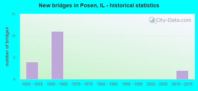
- New bridges - historical statistics
- 41950-1959
- 111960-1969
- 22010-2019
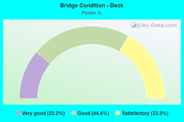
- Bridge Condition - Deck
- 22.2%Very good
- 44.4%Good
- 33.3%Satisfactory
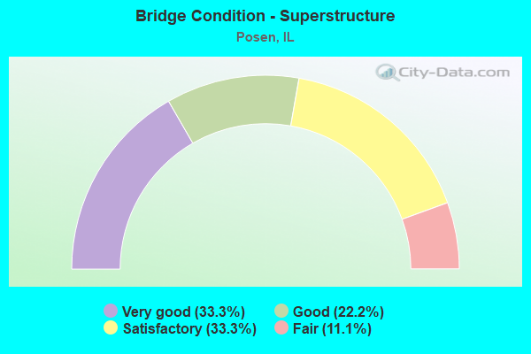
- Bridge Condition - Superstructure
- 33.3%Very good
- 22.2%Good
- 33.3%Satisfactory
- 11.1%Fair
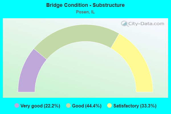
- Bridge Condition - Substructure
- 22.2%Very good
- 44.4%Good
- 33.3%Satisfactory
Find on map >> Show street view
Structure Number: 160054, Location: 0.6 M NE I294 (Lat: 41.623800, Lng: -87.680014), Route carried "on" structure: Interstate 57, Year Built: 1967, Year Reconstructed: 2003, Status: Open, Structure Length: 6.29m (20.64ft), Average Daily Traffic: 43,000 (year 2021), Truck Traffic: 7%, Average Future Daily Traffic: 59,277 (year 2032), Design Load: HS 20+Mod, Features Intersected: IL 83 (147TH ST)
Minimum Vertical Clearance: 30+ m (98+ ft), Kilometerpoint: 563.641, Lanes on structure: 3, Lanes under structure: 7, Base Highway Network: Yes, Owner: State Highway Agency, Approaching Roadway Width: 17.7m (58.1ft), Material/Design: Steel continuous, Design/Construction: Stringer/Multi-beam, Number Of Spans In Main Unit: 3, Length of Maximum Span: 33.8m (110.9ft), Curb-To-Curb Width: 17.1m (56.1ft), Out-to-Out Width: 18.0m (59.1ft)
Condition: Deck: Good, Superstructure: Satisfactory, Substructure: Good, Operating Rating: 89.1 metric tons, Method Used To Determine Operating Rating: Load Factor (LF) rating reported by rating factor (RF) method using MS18 loading, Inventory Rating: 76.8 metric tons, Method Used To Determine Inventory Rating: Load Factor (LF) rating reported by rating factor (RF) method using MS18 loading, Structural Evaluation: Equal to present minimum criteria, Deck Geometry: Equal to present minimum criteria, Underclear: High priority of corrective action, Approach Roadway Alignment: Equal to present desirable criteria, Designated Inspection Frequency: Every 24 months, Inspection Date: October 2020, Deck Structure Type: Concrete Cast-file-Place, Wearing Surface/Protective System: Deck Protection: Epoxy Coated Reinforcing
Find on map >> Show street view
Structure Number: 160055, Location: 0.6 M NE I294 (Lat: 41.623906, Lng: -87.679878), Route carried "on" structure: Interstate 57, Year Built: 1967, Year Reconstructed: 2002, Status: Open, Structure Length: 6.29m (20.64ft), Average Daily Traffic: 43,000 (year 2021), Truck Traffic: 7%, Average Future Daily Traffic: 59,277 (year 2032), Design Load: HS 20+Mod, Features Intersected: IL 83 (147TH ST)
Minimum Vertical Clearance: 30+ m (98+ ft), Kilometerpoint: 563.657, Lanes on structure: 3, Lanes under structure: 7, Base Highway Network: Yes, Owner: State Highway Agency, Approaching Roadway Width: 17.7m (58.1ft), Material/Design: Steel continuous, Design/Construction: Stringer/Multi-beam, Number Of Spans In Main Unit: 3, Length of Maximum Span: 33.8m (110.9ft), Curb-To-Curb Width: 17.1m (56.1ft), Out-to-Out Width: 18.0m (59.1ft)
Condition: Deck: Satisfactory, Superstructure: Satisfactory, Substructure: Satisfactory, Operating Rating: 89.1 metric tons, Method Used To Determine Operating Rating: Load Factor (LF) rating reported by rating factor (RF) method using MS18 loading, Inventory Rating: 76.8 metric tons, Method Used To Determine Inventory Rating: Load Factor (LF) rating reported by rating factor (RF) method using MS18 loading, Structural Evaluation: Equal to present minimum criteria, Deck Geometry: Equal to present minimum criteria, Underclear: High priority of corrective action, Approach Roadway Alignment: Equal to present desirable criteria, Designated Inspection Frequency: Every 24 months, Inspection Date: October 2020, Deck Structure Type: Concrete Cast-file-Place, Wearing Surface/Protective System: Deck Protection: Epoxy Coated Reinforcing
Find on map >> Show street view
Structure Number: 160056, Location: 0.2 M NE IL 83 (Lat: 41.626781, Lng: -87.676111), Route carried "on" structure: Interstate 57, Year Built: 1967, Year Reconstructed: 2021, Status: Open, Structure Length: 7.34m (24.08ft), Average Daily Traffic: 53,400 (year 2021), Truck Traffic: 6%, Average Future Daily Traffic: 71,379 (year 2032), Design Load: HS 20, Features Intersected: DIXIE HWY
Minimum Vertical Clearance: 30+ m (98+ ft), Kilometerpoint: 563.915, Lanes on structure: 4, Lanes under structure: 4, Base Highway Network: Yes, Owner: State Highway Agency, Approaching Roadway Width: 34.4m (112.9ft), Skew: 3 degrees, Material/Design: Steel continuous, Design/Construction: Stringer/Multi-beam, Number Of Spans In Main Unit: 3, Length of Maximum Span: 42.4m (139.1ft), Curb-To-Curb Width: 34.4m (112.9ft), Out-to-Out Width: 35.3m (115.8ft)
Condition: Deck: Good, Superstructure: Good, Substructure: Satisfactory, Operating Rating: 87.8 metric tons, Method Used To Determine Operating Rating: Load Factor (LF) rating reported by rating factor (RF) method using MS18 loading, Inventory Rating: 52.8 metric tons, Method Used To Determine Inventory Rating: Load Factor (LF) rating reported by rating factor (RF) method using MS18 loading, Structural Evaluation: Equal to present minimum criteria, Deck Geometry: Superior to present desirable criteria, Underclear: Somewhat better than minimum adequacy, Approach Roadway Alignment: Equal to present desirable criteria, Length Of Structure Improvement: 7.25m (23.79ft), Designated Inspection Frequency: Every 24 months, Inspection Date: May 2020, Bridge Improvement Cost: $1,206,000, Roadway Improvement Cost: $121,000, Total Project Cost: $1,809,000, Deck Structure Type: Concrete Cast-file-Place, Wearing Surface/Protective System: Deck Protection: Epoxy Coated Reinforcing
Find on map >> Show street view
Structure Number: 160057, Location: 0.2 M NE IL 83 (Lat: 41.626881, Lng: -87.675981), Route carried "on" structure: Interstate 57, Year Built: 1967, Year Reconstructed: 2021, Status: Open, Structure Length: 7.34m (24.08ft), Average Daily Traffic: 53,400 (year 2021), Truck Traffic: 6%, Average Future Daily Traffic: 71,379 (year 2032), Design Load: HS 20, Features Intersected: DIXIE HWY
Minimum Vertical Clearance: 30+ m (98+ ft), Kilometerpoint: 563.931, Lanes on structure: 3, Lanes under structure: 4, Base Highway Network: Yes, Owner: State Highway Agency, Approaching Roadway Width: 34.4m (112.9ft), Skew: 33 degrees, Material/Design: Steel continuous, Design/Construction: Stringer/Multi-beam, Number Of Spans In Main Unit: 3, Length of Maximum Span: 42.4m (139.1ft), Curb-To-Curb Width: 34.4m (112.9ft), Out-to-Out Width: 36.1m (118.4ft)
Condition: Deck: Good, Superstructure: Good, Substructure: Satisfactory, Operating Rating: 87.8 metric tons, Method Used To Determine Operating Rating: Load Factor (LF) rating reported by rating factor (RF) method using MS18 loading, Inventory Rating: 52.8 metric tons, Method Used To Determine Inventory Rating: Load Factor (LF) rating reported by rating factor (RF) method using MS18 loading, Structural Evaluation: Equal to present minimum criteria, Deck Geometry: Superior to present desirable criteria, Underclear: Somewhat better than minimum adequacy, Approach Roadway Alignment: Equal to present desirable criteria, Length Of Structure Improvement: 7.25m (23.79ft), Designated Inspection Frequency: Every 24 months, Inspection Date: May 2020, Bridge Improvement Cost: $831,000, Roadway Improvement Cost: $83,000, Total Project Cost: $1,371,000, Deck Structure Type: Concrete Cast-file-Place, Wearing Surface/Protective System: Deck Protection: Epoxy Coated Reinforcing
Find on map >> Show street view
Structure Number: 161012, Location: 7.4 M SW IL 1 (Lat: 41.621344, Lng: -87.683219), Route carried "on" structure: Interstate 57, Year Built: 1967, Year Reconstructed: 2021, Status: Open, Structure Length: 1.31m (4.30ft), Average Daily Traffic: 48,700 (year 2021), Truck Traffic: 5%, Average Future Daily Traffic: 62,676 (year 2032), Design Load: HS 20, Features Intersected: 149TH ST
Minimum Vertical Clearance: 30+ m (98+ ft), Kilometerpoint: 563.255, Lanes on structure: 4, Lanes under structure: 2, Base Highway Network: Yes, Owner: State Highway Agency, Approaching Roadway Width: 41.6m (136.5ft), Material/Design: Steel, Design/Construction: Stringer/Multi-beam, Number Of Spans In Main Unit: 1, Length of Maximum Span: 12.0m (39.4ft), Curb-To-Curb Width: 41.6m (136.5ft), Out-to-Out Width: 42.5m (139.4ft)
Condition: Deck: Satisfactory, Superstructure: Fair, Substructure: Good, Operating Rating: 81.0 metric tons, Method Used To Determine Operating Rating: Load Factor (LF) rating reported by rating factor (RF) method using MS18 loading, Inventory Rating: 48.6 metric tons, Method Used To Determine Inventory Rating: Load Factor (LF) rating reported by rating factor (RF) method using MS18 loading, Structural Evaluation: Somewhat better than minimum adequacy, Deck Geometry: Superior to present desirable criteria, Underclear: Meets minimum limits, Approach Roadway Alignment: Equal to present desirable criteria, Designated Inspection Frequency: Every 24 months, Inspection Date: Febuary 2020, Deck Structure Type: Concrete Cast-file-Place, Wearing Surface/Protective System: Deck Protection: Epoxy Coated Reinforcing
Find on map >> Show street view
Structure Number: 161051, Location: 7.4 M SW IL 1 (Lat: 41.621267, Lng: -87.683319), Route carried "on" structure: Interstate 57, Year Built: 1967, Year Reconstructed: 2021, Status: Open, Structure Length: 1.31m (4.30ft), Average Daily Traffic: 48,700 (year 2021), Truck Traffic: 5%, Average Future Daily Traffic: 62,676 (year 2032), Design Load: HS 20, Features Intersected: 149TH ST
Minimum Vertical Clearance: 30+ m (98+ ft), Kilometerpoint: 563.239, Lanes on structure: 4, Lanes under structure: 2, Base Highway Network: Yes, Owner: State Highway Agency, Approaching Roadway Width: 21.3m (69.9ft), Material/Design: Steel, Design/Construction: Stringer/Multi-beam, Number Of Spans In Main Unit: 1, Length of Maximum Span: 12.0m (39.4ft), Curb-To-Curb Width: 24.6m (80.7ft), Out-to-Out Width: 25.6m (84.0ft)
Condition: Deck: Satisfactory, Superstructure: Satisfactory, Substructure: Good, Operating Rating: 81.3 metric tons, Method Used To Determine Operating Rating: Load Factor (LF) rating reported by rating factor (RF) method using MS18 loading, Inventory Rating: 48.9 metric tons, Method Used To Determine Inventory Rating: Load Factor (LF) rating reported by rating factor (RF) method using MS18 loading, Structural Evaluation: Equal to present minimum criteria, Deck Geometry: Superior to present desirable criteria, Underclear: Meets minimum limits, Approach Roadway Alignment: Equal to present desirable criteria, Designated Inspection Frequency: Every 24 months, Inspection Date: Febuary 2020, Deck Structure Type: Concrete Cast-file-Place, Wearing Surface/Protective System: Deck Protection: Epoxy Coated Reinforcing
Find on map >> Show street view
Structure Number: 1641, Location: 0.6 Mi N of I-57 (Lat: 41.626314, Lng: -87.691839), Route carried "on" structure: Interstate 294, Year Built: 2014, Status: Open, Structure Length: 3.80m (12.47ft), Average Daily Traffic: 61,600 (year 2020), Truck Traffic: 16%, Average Future Daily Traffic: 45,835 (year 2032), Design Load: HS 25 or greater, Features Intersected: 147TH
Minimum Vertical Clearance: 30+ m (98+ ft), Kilometerpoint: 71.646, Lanes on structure: 2, Lanes under structure: 4, Base Highway Network: Yes, Toll: On toll road, Owner: State Toll Authority, Approaching Roadway Width: 12.8m (42.0ft), Skew: 2 degrees, Material/Design: Steel, Design/Construction: Stringer/Multi-beam, Number Of Spans In Main Unit: 1, Length of Maximum Span: 37.2m (122.0ft), Curb-To-Curb Width: 12.8m (42.0ft), Out-to-Out Width: 13.7m (44.9ft)
Condition: Deck: Very good, Superstructure: Very good, Substructure: Very good, Operating Rating: 71.9 metric tons, Method Used To Determine Operating Rating: Load and Resistance Factor Rating (LRFR) rating reported by rating factor(RF) method using HL-93 loadings, Inventory Rating: 55.4 metric tons, Method Used To Determine Inventory Rating: Load and Resistance Factor Rating (LRFR) rating reported by rating factor(RF) method using HL-93 loadings, Structural Evaluation: Equal to present desirable criteria, Deck Geometry: Equal to present desirable criteria, Approach Roadway Alignment: Equal to present desirable criteria, Designated Inspection Frequency: Every 24 months, Inspection Date: April 2020, Deck Structure Type: Concrete Cast-file-Place, Wearing Surface/Protective System: Deck Protection: Epoxy Coated Reinforcing
Find on map >> Show street view
Structure Number: 16986, Location: 0.6 M NW I55 P3 (Lat: 41.626447, Lng: -87.691914), Route carried "on" structure: Interstate 294, Year Built: 1958, Status: Open, Structure Length: 2.29m (7.51ft), Average Daily Traffic: 61,600 (year 2020), Truck Traffic: 16%, Average Future Daily Traffic: 45,835 (year 2032), Features Intersected: ILL 83 (147TH ST)
Minimum Vertical Clearance: 30+ m (98+ ft), Kilometerpoint: 71.630, Lanes on structure: 2, Lanes under structure: 4, Base Highway Network: Yes, Toll: On toll road, Owner: State Toll Authority, Approaching Roadway Width: 12.2m (40.0ft), Skew: 2 degrees, Material/Design: Prestressed concrete, Number Of Spans In Main Unit: 1, Length of Maximum Span: 21.9m (71.9ft), Curb-To-Curb Width: 10.5m (34.4ft), Out-to-Out Width: 18.6m (61.0ft)
Condition: Deck: Very good, Superstructure: Very good, Substructure: Very good, Operating Rating: 50.9 metric tons, Method Used To Determine Operating Rating: Load and Resistance Factor Rating (LRFR) rating reported by rating factor(RF) method using HL-93 loadings, Inventory Rating: 39.2 metric tons, Method Used To Determine Inventory Rating: Load and Resistance Factor Rating (LRFR) rating reported by rating factor(RF) method using HL-93 loadings, Structural Evaluation: Equal to present desirable criteria, Deck Geometry: Meets minimum limits, Underclear: Meets minimum limits, Approach Roadway Alignment: Equal to present desirable criteria, Designated Inspection Frequency: Every 24 months, Inspection Date: April 2020, Deck Structure Type: Concrete Cast-file-Place, Wearing Surface/Protective System: Wearing Surface: Bituminous, Membrane: Built-up
Find on map >> Show street view
Structure Number: 169861, Location: 0.7 M NW I55 P3 (Lat: 41.626314, Lng: -87.691839), Route carried "on" structure: Interstate 294, Year Built: 1958, Status: Open, Structure Length: 2.29m (7.51ft), Average Daily Traffic: 61,600 (year 2020), Truck Traffic: 16%, Average Future Daily Traffic: 45,835 (year 2032), Features Intersected: ILL 83 (147TH ST)
Minimum Vertical Clearance: 30+ m (98+ ft), Kilometerpoint: 71.646, Lanes on structure: 2, Lanes under structure: 4, Base Highway Network: Yes, Toll: On toll road, Owner: State Toll Authority, Approaching Roadway Width: 12.2m (40.0ft), Skew: 2 degrees, Material/Design: Prestressed concrete, Number Of Spans In Main Unit: 1, Length of Maximum Span: 21.9m (71.9ft), Curb-To-Curb Width: 10.5m (34.4ft), Out-to-Out Width: 18.6m (61.0ft)
Condition: Deck: Good, Superstructure: Very good, Substructure: Good, Operating Rating: 50.5 metric tons, Method Used To Determine Operating Rating: Load and Resistance Factor Rating (LRFR) rating reported by rating factor(RF) method using HL-93 loadings, Inventory Rating: 38.9 metric tons, Method Used To Determine Inventory Rating: Load and Resistance Factor Rating (LRFR) rating reported by rating factor(RF) method using HL-93 loadings, Structural Evaluation: Better than present minimum criteria, Deck Geometry: Meets minimum limits, Underclear: Meets minimum limits, Approach Roadway Alignment: Equal to present desirable criteria, Designated Inspection Frequency: Every 24 months, Inspection Date: April 2020, Deck Structure Type: Concrete Cast-file-Place, Wearing Surface/Protective System: Wearing Surface: Bituminous
Find on map >> Show street view
Structure Number: 160054, Location: 0.6 M NE I294 (Lat: 41.624011, Lng: -87.679739), Route carried "under" structure: State highway 83, Year Built: 1967, Structure Length: 0. m, Average Daily Traffic: 27,600 (year 2021), Truck Traffic: 9%, Features Intersected: IL 83 (147TH ST), Facility Carried by Structure: I- 57 NB
Minimum Vertical Clearance: 4.47m (14.67ft), Kilometerpoint: 24.027, Lanes on structure: 3, Lanes under structure: 7, Material/Design: Steel continuous, Design/Construction: Stringer/Multi-beam, Length of Maximum Span: 33.8m (110.9ft)
Find on map >> Show street view
Structure Number: 160055, Location: 0.6 M NE I294 (Lat: 41.624139, Lng: -87.679947), Route carried "under" structure: State highway 83, Year Built: 1967, Structure Length: 0. m, Average Daily Traffic: 27,600 (year 2021), Truck Traffic: 9%, Features Intersected: IL 83 (147TH ST), Facility Carried by Structure: I- 57 SB
Minimum Vertical Clearance: 4.65m (15.26ft), Kilometerpoint: 24.027, Lanes on structure: 3, Lanes under structure: 7, Material/Design: Steel continuous, Design/Construction: Stringer/Multi-beam, Length of Maximum Span: 33.8m (110.9ft)
Find on map >> Show street view
Structure Number: 160057, Location: 0.2 M NE IL 83 (Lat: 41.626878, Lng: -87.675819), Route carried "under" structure: Other road , Year Built: 1967, Structure Length: 0. m, Average Daily Traffic: 9,100 (year 2018), Truck Traffic: 12%, Features Intersected: DIXIE HWY, Facility Carried by Structure: I- 57 SB
Minimum Vertical Clearance: 4.80m (15.75ft), Kilometerpoint: 40.490, Lanes on structure: 3, Lanes under structure: 4, Material/Design: Steel continuous, Design/Construction: Stringer/Multi-beam, Length of Maximum Span: 42.4m (139.1ft)
Find on map >> Show street view
Structure Number: 161012, Location: 7.4 M SW IL 1 (Lat: 41.622603, Lng: -87.683764), Route carried "under" structure: City street , Year Built: 1967, Structure Length: 0. m, Average Daily Traffic: 125 (year 2018), Truck Traffic: 13%, Features Intersected: 149TH ST, Facility Carried by Structure: I- 57 SB
Minimum Vertical Clearance: 4.45m (14.60ft), Kilometerpoint: 0.274, Lanes on structure: 4, Lanes under structure: 2, Material/Design: Steel, Design/Construction: Stringer/Multi-beam, Length of Maximum Span: 12.0m (39.4ft)
Find on map >> Show street view
Structure Number: 161051, Location: 7.4 M SW IL 1 (Lat: 41.622608, Lng: -87.683622), Route carried "under" structure: City street , Year Built: 1967, Structure Length: 0. m, Average Daily Traffic: 125 (year 2018), Truck Traffic: 13%, Features Intersected: 149TH ST, Facility Carried by Structure: I- 57 NB
Minimum Vertical Clearance: 4.45m (14.60ft), Kilometerpoint: 0.274, Lanes on structure: 4, Lanes under structure: 2, Material/Design: Steel, Design/Construction: Stringer/Multi-beam, Length of Maximum Span: 12.0m (39.4ft)
Find on map >> Show street view
Structure Number: 1641, Location: 0.6 Mi N of I-57 (Lat: 41.626050, Lng: -87.691761), Route carried "under" structure: State highway 83, Year Built: 2014, Structure Length: 0. m, Average Daily Traffic: 19,800 (year 2021), Truck Traffic: 4%, Features Intersected: 147TH, Facility Carried by Structure: I294NB CD ROAD B
Minimum Vertical Clearance: 4.57m (14.99ft), Kilometerpoint: 25.105, Lanes on structure: 2, Lanes under structure: 4, Toll: On toll road, Material/Design: Steel, Design/Construction: Stringer/Multi-beam, Length of Maximum Span: 37.2m (122.0ft)
Find on map >> Show street view
Structure Number: 16986, Location: 0.6 M NW I55 P3 (Lat: 41.626047, Lng: -87.691900), Route carried "under" structure: State highway 83, Year Built: 1958, Structure Length: 0. m, Average Daily Traffic: 19,800 (year 2021), Truck Traffic: 4%, Features Intersected: ILL 83 (147TH ST), Facility Carried by Structure: I-294 SB
Minimum Vertical Clearance: 4.45m (14.60ft), Kilometerpoint: 25.137, Lanes on structure: 2, Lanes under structure: 4, Toll: On toll road, Material/Design: Prestressed concrete, Length of Maximum Span: 21.9m (71.9ft)
Find on map >> Show street view
Structure Number: 169861, Location: 0.7 M NW I55 P3 (Lat: 41.626050, Lng: -87.691761), Route carried "under" structure: State highway 83, Year Built: 1958, Structure Length: 0. m, Average Daily Traffic: 19,800 (year 2021), Truck Traffic: 4%, Features Intersected: ILL 83 (147TH ST), Facility Carried by Structure: I-294 NB
Minimum Vertical Clearance: 4.45m (14.60ft), Kilometerpoint: 25.105, Lanes on structure: 2, Lanes under structure: 4, Toll: On toll road, Material/Design: Prestressed concrete, Length of Maximum Span: 21.9m (71.9ft)