Bridge Statistics for Poyen, Arkansas (AR)
Condition, Traffic, Stress, Structural Evaluation, Project Costs
- National Bridge Inventory (NBI) Statistics
- 13Number of bridges
- 279ft / 84.7mTotal length
- $301,000Total costs
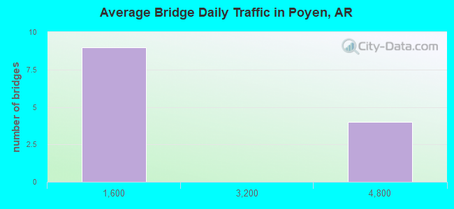
- 21,888Total average daily traffic
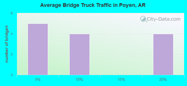
- 3,083Total average daily truck traffic
- 23,989Total future (year 2007) average daily traffic
- National Bridge Inventory (NBI) Registered Bridges for Poyen
- No street view available for this location
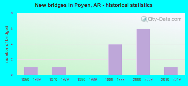
- New bridges - historical statistics
- 11960-1969
- 11970-1979
- 41990-1999
- 62000-2009
- 12010-2019
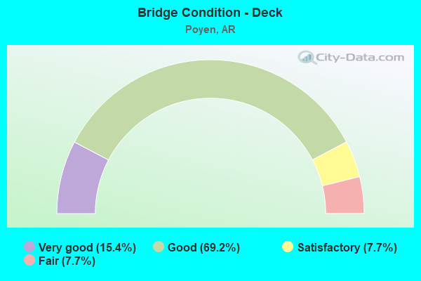
- Bridge Condition - Deck
- 15.4%Very good
- 69.2%Good
- 7.7%Satisfactory
- 7.7%Fair
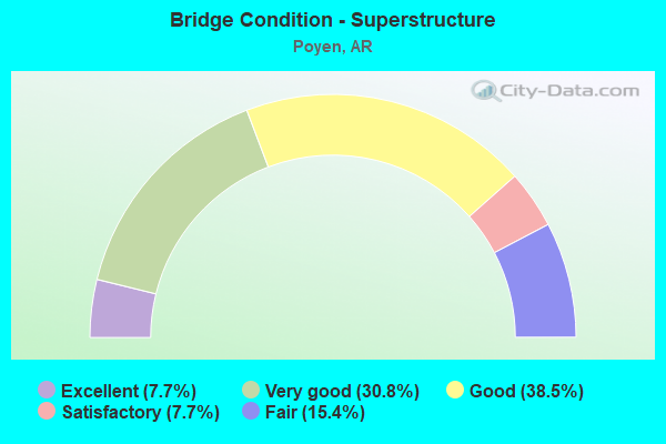
- Bridge Condition - Superstructure
- 7.7%Excellent
- 30.8%Very good
- 38.5%Good
- 7.7%Satisfactory
- 15.4%Fair
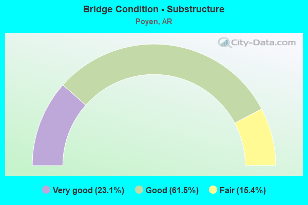
- Bridge Condition - Substructure
- 23.1%Very good
- 61.5%Good
- 15.4%Fair
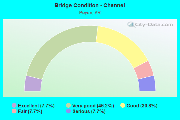
- Bridge Condition - Channel
- 7.7%Excellent
- 46.2%Very good
- 30.8%Good
- 7.7%Fair
- 7.7%Serious
Find on map >> Show street view
Structure Number: 4306, Location: 2 MI WEST OF ODGEN (Lat: 33.597953, Lng: -94.086617), Route carried "on" structure: County highway 23, Year Built: 1976, Status: Open, Structure Length: 3.78m (12.40ft), Average Daily Traffic: 580 (year 2018), Truck Traffic: 1%, Average Future Daily Traffic: 296 (year 2007), Design Load: H 15, Features Intersected: FISH LAKE
Minimum Vertical Clearance: 30+ m (98+ ft), Kilometerpoint: 2.913, Lanes on structure: 2, Owner: County Highway Agency, Approaching Roadway Width: 6.1m (20.0ft), Skew: 3 degrees, Material/Design: Concrete, Design/Construction: Slab, Number Of Spans In Main Unit: 4, Length of Maximum Span: 9.4m (30.8ft), Curb-To-Curb Width: 7.3m (24.0ft), Out-to-Out Width: 8.1m (26.6ft)
Condition: Deck: Good, Superstructure: Good, Substructure: Good, Channel: Good, Operating Rating: 49.0 metric tons, Method Used To Determine Operating Rating: Load Factor (LF), Inventory Rating: 29.0 metric tons, Method Used To Determine Inventory Rating: Load Factor (LF), Structural Evaluation: Better than present minimum criteria, Deck Geometry: Meets minimum limits, Waterway Adequacy: Equal to present desirable criteria, Approach Roadway Alignment: Better than present minimum criteria, Designated Inspection Frequency: Every 24 months, Critical Feature Inspection Frequency: Every 24 months, Inspection Date: July 2021, Deck Structure Type: Concrete Cast-file-Place, Wearing Surface/Protective System: Wearing Surface: Monolithic Concrete
Find on map >> Show street view
Structure Number: 6706, Location: 1.5 Mi E SH 229-Poyen (Lat: 34.321439, Lng: -92.619550), Route carried "on" structure: US 270, Year Built: 1999, Status: Open, Structure Length: 9.00m (29.53ft), Average Daily Traffic: 4,000 (year 2018), Truck Traffic: 17%, Average Future Daily Traffic: 4,321 (year 2028), Design Load: HS 20+Mod, Features Intersected: Francois Creek
Minimum Vertical Clearance: 30+ m (98+ ft), Kilometerpoint: 5.552, Lanes on structure: 2, Base Highway Network: Yes, Owner: State Highway Agency, Approaching Roadway Width: 11.9m (39.0ft), Material/Design: Concrete, Design/Construction: Tee Beam, Number Of Spans In Main Unit: 9, Length of Maximum Span: 10.1m (33.1ft), Curb-To-Curb Width: 12.0m (39.4ft), Out-to-Out Width: 12.8m (42.0ft)
Condition: Deck: Good, Superstructure: Good, Substructure: Good, Channel: Very good, Operating Rating: 54.4 metric tons, Method Used To Determine Operating Rating: Load Factor (LF), Inventory Rating: 32.7 metric tons, Method Used To Determine Inventory Rating: Load Factor (LF), Structural Evaluation: Better than present minimum criteria, Deck Geometry: Somewhat better than minimum adequacy, Waterway Adequacy: Equal to present desirable criteria, Approach Roadway Alignment: Equal to present desirable criteria, Designated Inspection Frequency: Every 24 months, Critical Feature Inspection Frequency: Every 24 months, Inspection Date: September 2021, Deck Structure Type: Concrete Cast-file-Place, Wearing Surface/Protective System: Wearing Surface: Monolithic Concrete, Deck Protection: Epoxy Coated Reinforcing
Find on map >> Show street view
Structure Number: 6707, Location: 1.7 Mi E SH 229-Poyen (Lat: 34.320758, Lng: -92.609153), Route carried "on" structure: US 270, Year Built: 1999, Status: Open, Structure Length: 12.00m (39.37ft), Average Daily Traffic: 4,000 (year 2018), Truck Traffic: 17%, Average Future Daily Traffic: 4,321 (year 2028), Design Load: HS 20+Mod, Features Intersected: Saline River Relief
Minimum Vertical Clearance: 30+ m (98+ ft), Kilometerpoint: 6.518, Lanes on structure: 2, Base Highway Network: Yes, Owner: State Highway Agency, Approaching Roadway Width: 11.9m (39.0ft), Material/Design: Concrete, Design/Construction: Tee Beam, Number Of Spans In Main Unit: 12, Length of Maximum Span: 10.1m (33.1ft), Curb-To-Curb Width: 12.0m (39.4ft), Out-to-Out Width: 12.8m (42.0ft)
Condition: Deck: Good, Superstructure: Good, Substructure: Good, Channel: Good, Operating Rating: 54.4 metric tons, Method Used To Determine Operating Rating: Load Factor (LF), Inventory Rating: 32.7 metric tons, Method Used To Determine Inventory Rating: Load Factor (LF), Structural Evaluation: Better than present minimum criteria, Deck Geometry: Somewhat better than minimum adequacy, Waterway Adequacy: Equal to present desirable criteria, Approach Roadway Alignment: Equal to present desirable criteria, Designated Inspection Frequency: Every 24 months, Critical Feature Inspection Frequency: Every 24 months, Inspection Date: September 2021, Deck Structure Type: Concrete Cast-file-Place, Wearing Surface/Protective System: Wearing Surface: Monolithic Concrete, Deck Protection: Epoxy Coated Reinforcing
Find on map >> Show street view
Structure Number: 6708, Location: 2.2 Mi E SH 229-Poyen (Lat: 34.320186, Lng: -92.600281), Route carried "on" structure: US 270, Year Built: 1999, Status: Open, Structure Length: 16.00m (52.49ft), Average Daily Traffic: 4,000 (year 2018), Truck Traffic: 17%, Average Future Daily Traffic: 4,321 (year 2028), Design Load: HS 20+Mod, Features Intersected: Saline River Relief
Minimum Vertical Clearance: 30+ m (98+ ft), Kilometerpoint: 7.339, Lanes on structure: 2, Base Highway Network: Yes, Owner: State Highway Agency, Approaching Roadway Width: 11.9m (39.0ft), Material/Design: Concrete, Design/Construction: Tee Beam, Number Of Spans In Main Unit: 16, Length of Maximum Span: 10.1m (33.1ft), Curb-To-Curb Width: 12.0m (39.4ft), Out-to-Out Width: 12.8m (42.0ft)
Condition: Deck: Good, Superstructure: Good, Substructure: Good, Channel: Very good, Operating Rating: 54.4 metric tons, Method Used To Determine Operating Rating: Load Factor (LF), Inventory Rating: 32.7 metric tons, Method Used To Determine Inventory Rating: Load Factor (LF), Structural Evaluation: Better than present minimum criteria, Deck Geometry: Somewhat better than minimum adequacy, Waterway Adequacy: Equal to present desirable criteria, Approach Roadway Alignment: Equal to present desirable criteria, Designated Inspection Frequency: Every 24 months, Critical Feature Inspection Frequency: Every 24 months, Inspection Date: September 2021, Deck Structure Type: Concrete Cast-file-Place, Wearing Surface/Protective System: Wearing Surface: Monolithic Concrete, Deck Protection: Epoxy Coated Reinforcing
Find on map >> Show street view
Structure Number: 674, Location: 3.8 Mi S US 270-Poyen (Lat: 34.270861, Lng: -92.626600), Route carried "on" structure: State highway 229, Year Built: 2002, Status: Open, Structure Length: 2.71m (8.89ft), Average Daily Traffic: 650 (year 2018), Truck Traffic: 8%, Average Future Daily Traffic: 966 (year 2028), Design Load: HS 20, Features Intersected: Mud Creek
Minimum Vertical Clearance: 30+ m (98+ ft), Kilometerpoint: 11.909, Lanes on structure: 2, Owner: State Highway Agency, Approaching Roadway Width: 9.1m (29.9ft), Material/Design: Concrete, Design/Construction: Tee Beam, Number Of Spans In Main Unit: 3, Length of Maximum Span: 9.1m (29.9ft), Curb-To-Curb Width: 9.0m (29.5ft), Out-to-Out Width: 9.9m (32.5ft)
Condition: Deck: Good, Superstructure: Very good, Substructure: Good, Channel: Very good, Operating Rating: 54.4 metric tons, Method Used To Determine Operating Rating: Load Factor (LF), Inventory Rating: 32.7 metric tons, Method Used To Determine Inventory Rating: Load Factor (LF), Structural Evaluation: Better than present minimum criteria, Deck Geometry: Somewhat better than minimum adequacy, Waterway Adequacy: Equal to present desirable criteria, Approach Roadway Alignment: Equal to present desirable criteria, Designated Inspection Frequency: Every 24 months, Critical Feature Inspection Frequency: Every 24 months, Inspection Date: September 2021, Deck Structure Type: Concrete Cast-file-Place, Wearing Surface/Protective System: Wearing Surface: Monolithic Concrete, Deck Protection: Epoxy Coated Reinforcing
Find on map >> Show street view
Structure Number: 6741, Location: 2.2 Mi S US 270-Poyen (Lat: 34.292311, Lng: -92.635781), Route carried "on" structure: State highway 229, Year Built: 2002, Status: Open, Structure Length: 4.51m (14.80ft), Average Daily Traffic: 650 (year 2018), Truck Traffic: 8%, Average Future Daily Traffic: 966 (year 2028), Design Load: HS 20, Features Intersected: Husky Creek
Minimum Vertical Clearance: 30+ m (98+ ft), Kilometerpoint: 14.420, Lanes on structure: 2, Owner: State Highway Agency, Approaching Roadway Width: 9.1m (29.9ft), Material/Design: Concrete, Design/Construction: Tee Beam, Number Of Spans In Main Unit: 5, Length of Maximum Span: 9.1m (29.9ft), Curb-To-Curb Width: 9.0m (29.5ft), Out-to-Out Width: 9.9m (32.5ft)
Condition: Deck: Good, Superstructure: Very good, Substructure: Very good, Channel: Very good, Operating Rating: 54.4 metric tons, Method Used To Determine Operating Rating: Load Factor (LF), Inventory Rating: 32.7 metric tons, Method Used To Determine Inventory Rating: Load Factor (LF), Structural Evaluation: Equal to present desirable criteria, Deck Geometry: Somewhat better than minimum adequacy, Waterway Adequacy: Equal to present desirable criteria, Approach Roadway Alignment: Equal to present desirable criteria, Designated Inspection Frequency: Every 24 months, Critical Feature Inspection Frequency: Every 24 months, Inspection Date: September 2021, Deck Structure Type: Concrete Cast-file-Place, Wearing Surface/Protective System: Wearing Surface: Monolithic Concrete, Deck Protection: Epoxy Coated Reinforcing
Find on map >> Show street view
Structure Number: 6742, Location: 1.9 Mi S US 270-Poyen (Lat: 34.296481, Lng: -92.637550), Route carried "on" structure: State highway 229, Year Built: 2002, Status: Open, Structure Length: 4.51m (14.80ft), Average Daily Traffic: 650 (year 2018), Truck Traffic: 8%, Average Future Daily Traffic: 966 (year 2028), Design Load: HS 20, Features Intersected: Clear Creek
Minimum Vertical Clearance: 30+ m (98+ ft), Kilometerpoint: 14.999, Lanes on structure: 2, Owner: State Highway Agency, Approaching Roadway Width: 9.8m (32.2ft), Material/Design: Concrete, Design/Construction: Tee Beam, Number Of Spans In Main Unit: 5, Length of Maximum Span: 9.1m (29.9ft), Curb-To-Curb Width: 9.0m (29.5ft), Out-to-Out Width: 9.9m (32.5ft)
Condition: Deck: Good, Superstructure: Very good, Substructure: Very good, Channel: Very good, Operating Rating: 54.4 metric tons, Method Used To Determine Operating Rating: Load Factor (LF), Inventory Rating: 32.7 metric tons, Method Used To Determine Inventory Rating: Load Factor (LF), Structural Evaluation: Equal to present desirable criteria, Deck Geometry: Somewhat better than minimum adequacy, Waterway Adequacy: Equal to present desirable criteria, Approach Roadway Alignment: Equal to present desirable criteria, Designated Inspection Frequency: Every 24 months, Critical Feature Inspection Frequency: Every 24 months, Inspection Date: September 2021, Deck Structure Type: Concrete Cast-file-Place, Wearing Surface/Protective System: Wearing Surface: Monolithic Concrete, Deck Protection: Epoxy Coated Reinforcing
Find on map >> Show street view
Structure Number: 6743, Location: 0.7 Mi S US 270-Poyen (Lat: 34.314119, Lng: -92.640319), Route carried "on" structure: State highway 229, Year Built: 2001, Status: Open, Structure Length: 8.11m (26.61ft), Average Daily Traffic: 650 (year 2018), Truck Traffic: 8%, Average Future Daily Traffic: 966 (year 2028), Design Load: HS 20, Features Intersected: Big Creek
Minimum Vertical Clearance: 30+ m (98+ ft), Kilometerpoint: 16.898, Lanes on structure: 2, Owner: State Highway Agency, Approaching Roadway Width: 9.8m (32.2ft), Material/Design: Concrete, Design/Construction: Tee Beam, Number Of Spans In Main Unit: 9, Length of Maximum Span: 9.1m (29.9ft), Curb-To-Curb Width: 9.0m (29.5ft), Out-to-Out Width: 9.9m (32.5ft)
Condition: Deck: Good, Superstructure: Very good, Substructure: Good, Channel: Good, Operating Rating: 54.4 metric tons, Method Used To Determine Operating Rating: Load Factor (LF), Inventory Rating: 32.7 metric tons, Method Used To Determine Inventory Rating: Load Factor (LF), Structural Evaluation: Better than present minimum criteria, Deck Geometry: Somewhat better than minimum adequacy, Waterway Adequacy: Equal to present desirable criteria, Approach Roadway Alignment: Equal to present desirable criteria, Designated Inspection Frequency: Every 24 months, Critical Feature Inspection Frequency: Every 24 months, Inspection Date: September 2021, Deck Structure Type: Concrete Cast-file-Place, Wearing Surface/Protective System: Wearing Surface: Monolithic Concrete, Deck Protection: Epoxy Coated Reinforcing
Find on map >> Show street view
Structure Number: 6744, Location: 2.0 Mi N US 270-Poyen (Lat: 34.352567, Lng: -92.632339), Route carried "on" structure: State highway 229, Year Built: 2002, Status: Open, Structure Length: 9.97m (32.71ft), Average Daily Traffic: 490 (year 2018), Truck Traffic: 1%, Average Future Daily Traffic: 445 (year 2028), Design Load: HS 20, Features Intersected: Francois Creek
Minimum Vertical Clearance: 30+ m (98+ ft), Kilometerpoint: 21.259, Lanes on structure: 2, Owner: State Highway Agency, Approaching Roadway Width: 9.4m (30.8ft), Material/Design: Concrete, Design/Construction: Slab, Number Of Spans In Main Unit: 11, Length of Maximum Span: 9.1m (29.9ft), Curb-To-Curb Width: 9.0m (29.5ft), Out-to-Out Width: 9.9m (32.5ft)
Condition: Deck: Good, Superstructure: Good, Substructure: Good, Channel: Very good, Operating Rating: 54.4 metric tons, Method Used To Determine Operating Rating: Load Factor (LF), Inventory Rating: 32.7 metric tons, Method Used To Determine Inventory Rating: Load Factor (LF), Structural Evaluation: Better than present minimum criteria, Deck Geometry: Somewhat better than minimum adequacy, Waterway Adequacy: Equal to present desirable criteria, Approach Roadway Alignment: Equal to present desirable criteria, Designated Inspection Frequency: Every 24 months, Critical Feature Inspection Frequency: Every 24 months, Inspection Date: September 2021, Deck Structure Type: Concrete Cast-file-Place, Wearing Surface/Protective System: Wearing Surface: Monolithic Concrete, Deck Protection: Epoxy Coated Reinforcing
Find on map >> Show street view
Structure Number: 7362, Location: 0.42 Mi E HSprngsCo-Poyen (Lat: 34.340169, Lng: -92.663650), Route carried "on" structure: US 270, Year Built: 2017, Status: Open, Structure Length: 3.38m (11.09ft), Average Daily Traffic: 4,500 (year 2018), Truck Traffic: 18%, Average Future Daily Traffic: 5,900 (year 2038), Design Load: HL 93, Features Intersected: Big Creek
Minimum Vertical Clearance: 30+ m (98+ ft), Kilometerpoint: 0.676, Lanes on structure: 2, Base Highway Network: Yes, Owner: State Highway Agency, Approaching Roadway Width: 12.2m (40.0ft), Material/Design: Steel continuous, Design/Construction: Stringer/Multi-beam, Number Of Spans In Main Unit: 3, Length of Maximum Span: 12.2m (40.0ft), Curb or Sidewalk Widths: Left: 0.5m (1.6ft), Right: 0.5m (1.6ft), Curb-To-Curb Width: 12.2m (40.0ft), Out-to-Out Width: 13.2m (43.3ft)
Condition: Deck: Very good, Superstructure: Excellent, Substructure: Very good, Channel: Excellent, Operating Rating: 49.9 metric tons, Method Used To Determine Operating Rating: Load and Resistance Factor (LRFR), Inventory Rating: 32.7 metric tons, Method Used To Determine Inventory Rating: Load and Resistance Factor (LRFR), Structural Evaluation: Equal to present desirable criteria, Deck Geometry: Equal to present minimum criteria, Waterway Adequacy: Equal to present desirable criteria, Approach Roadway Alignment: Equal to present desirable criteria, Designated Inspection Frequency: Every 24 months, Critical Feature Inspection Frequency: Every 24 months, Inspection Date: September 2021, Deck Structure Type: Concrete Cast-file-Place
Find on map >> Show street view
Structure Number: 18317, Location: 8.70 MI SE SH 16 (Lat: 35.969939, Lng: -94.068147), Route carried "on" structure: County highway 57, Year Built: 1969, Status: Posted for load, Structure Length: 6.89m (22.60ft), Average Daily Traffic: 1,400 (year 2018), Truck Traffic: 1%, Average Future Daily Traffic: 186 (year 2007), Design Load: H 15, Features Intersected: Middle Fork White River, Facility Carried by Structure: East Black Oak Rd.
Minimum Vertical Clearance: 30+ m (98+ ft), Kilometerpoint: 10.894, Lanes on structure: 2, Owner: County Highway Agency, Approaching Roadway Width: 7.3m (24.0ft), Skew: 2 degrees, Material/Design: Steel, Design/Construction: Stringer/Multi-beam, Number Of Spans In Main Unit: 5, Length of Maximum Span: 15.5m (50.9ft), Curb-To-Curb Width: 7.6m (24.9ft), Out-to-Out Width: 7.6m (24.9ft)
Condition: Deck: Satisfactory, Superstructure: Satisfactory, Substructure: Fair, Channel: Serious, Operating Rating: 12.7 metric tons, Method Used To Determine Operating Rating: Load Factor (LF), Inventory Rating: 8.2 metric tons, Method Used To Determine Inventory Rating: Load Factor (LF), Structural Evaluation: High priority of corrective action, Deck Geometry: Meets minimum limits, Waterway Adequacy: Equal to present desirable criteria, Approach Roadway Alignment: Better than present minimum criteria, Bridge Posting: Required (Relationship of Operating Rating to Maximum Legal Load: > 39.9% below), Designated Inspection Frequency: Every 24 months, Inspection Date: March 2021, Deck Structure Type: Concrete Cast-file-Place, Wearing Surface/Protective System: Wearing Surface: Monolithic Concrete
Find on map >> Show street view
Structure Number: 21108, Location: 5.9 MI S JCT CR 61 & 270 (Lat: 34.291419, Lng: -92.677039), Route carried "on" structure: County highway 61, Year Built: 1992, Status: Open, Structure Length: 2.74m (8.99ft), Average Daily Traffic: 159 (year 2018), Truck Traffic: 1%, Average Future Daily Traffic: 122 (year 2007), Features Intersected: Keisler Creek
Minimum Vertical Clearance: 30+ m (98+ ft), Kilometerpoint: 9.429, Lanes on structure: 1, Owner: County Highway Agency, Approaching Roadway Width: 5.5m (18.0ft), Material/Design: Steel continuous, Design/Construction: Orthotropic, Number Of Spans In Main Unit: 6, Length of Maximum Span: 9.1m (29.9ft), Curb-To-Curb Width: 5.2m (17.1ft), Out-to-Out Width: 5.4m (17.7ft)
Condition: Deck: Fair, Superstructure: Fair, Substructure: Fair, Channel: Fair, Operating Rating: 33.6 metric tons, Method Used To Determine Operating Rating: Load Factor (LF), Inventory Rating: 20.0 metric tons, Method Used To Determine Inventory Rating: Load Factor (LF), Structural Evaluation: Somewhat better than minimum adequacy, Deck Geometry: High priority of replacement, Waterway Adequacy: Equal to present desirable criteria, Approach Roadway Alignment: Equal to present minimum criteria, Length Of Structure Improvement: 3.54m (11.61ft), Designated Inspection Frequency: Every 24 months, Critical Feature Inspection Frequency: Every 12 months, Inspection Date: November 2021, Critical Feature Inspection Date: November 2021, Roadway Improvement Cost: $109,000, Total Project Cost: $301,000, Deck Structure Type: Steel plate, Wearing Surface/Protective System: Wearing Surface: Bituminous
Find on map >> Show street view
Structure Number: 23213, Location: 8 MI ESE MALVERN (Lat: 34.306086, Lng: -92.686308), Route carried "on" structure: County highway 61, Year Built: 2009, Status: Posted for load, Structure Length: 1.06m (3.48ft), Average Daily Traffic: 159 (year 2018), Truck Traffic: 1%, Average Future Daily Traffic: 213 (year 2007), Features Intersected: THUNDER BRANCH
Minimum Vertical Clearance: 30+ m (98+ ft), Kilometerpoint: 7.435, Lanes on structure: 2, Owner: County Highway Agency, Approaching Roadway Width: 6.7m (22.0ft), Material/Design: Steel, Design/Construction: Stringer/Multi-beam, Number Of Spans In Main Unit: 1, Length of Maximum Span: 10.1m (33.1ft), Curb-To-Curb Width: 7.3m (24.0ft), Out-to-Out Width: 7.5m (24.6ft)
Condition: Deck: Very good, Superstructure: Fair, Substructure: Good, Channel: Good, Operating Rating: 54.4 metric tons, Method Used To Determine Operating Rating: Load Factor (LF), Inventory Rating: 32.7 metric tons, Method Used To Determine Inventory Rating: Load Factor (LF), Structural Evaluation: Somewhat better than minimum adequacy, Deck Geometry: Somewhat better than minimum adequacy, Waterway Adequacy: Equal to present minimum criteria, Approach Roadway Alignment: Equal to present desirable criteria, Designated Inspection Frequency: Every 24 months, Critical Feature Inspection Frequency: Every 24 months, Inspection Date: January 2021, Deck Structure Type: Concrete Cast-file-Place, Wearing Surface/Protective System: Wearing Surface: Monolithic Concrete