Bridge Statistics for Princetown, New York (NY)
Condition, Traffic, Stress, Structural Evaluation, Project Costs
- National Bridge Inventory (NBI) Statistics
- 19Number of bridges
- 213ft / 65.2mTotal length
- $35,849,000Total costs
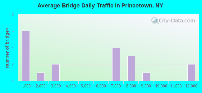
- 86,981Total average daily traffic
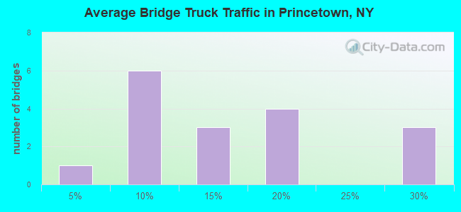
- 11,935Total average daily truck traffic
- National Bridge Inventory (NBI) Registered Bridges for Princetown
- No street view available for this location
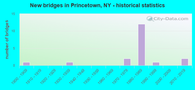
- New bridges - historical statistics
- 11900-1909
- 11930-1939
- 21970-1979
- 121980-1989
- 11990-1999
- 22010-2019
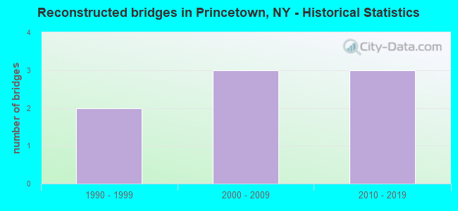
- Reconstructed bridges - Historical Statistics
- 21990-1999
- 32000-2009
- 32010-2019
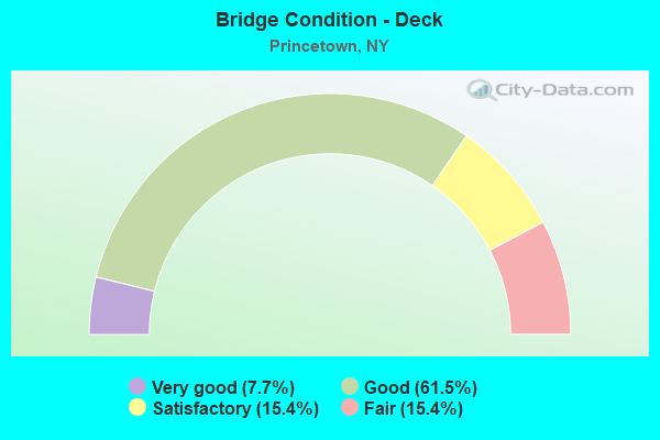
- Bridge Condition - Deck
- 7.7%Very good
- 61.5%Good
- 15.4%Satisfactory
- 15.4%Fair
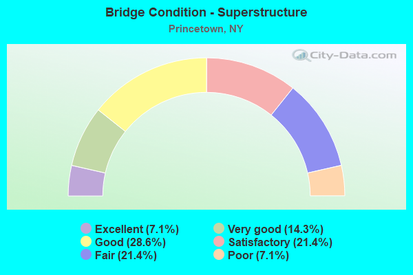
- Bridge Condition - Superstructure
- 7.1%Excellent
- 14.3%Very good
- 28.6%Good
- 21.4%Satisfactory
- 21.4%Fair
- 7.1%Poor
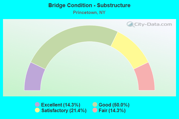
- Bridge Condition - Substructure
- 14.3%Excellent
- 50.0%Good
- 21.4%Satisfactory
- 14.3%Fair
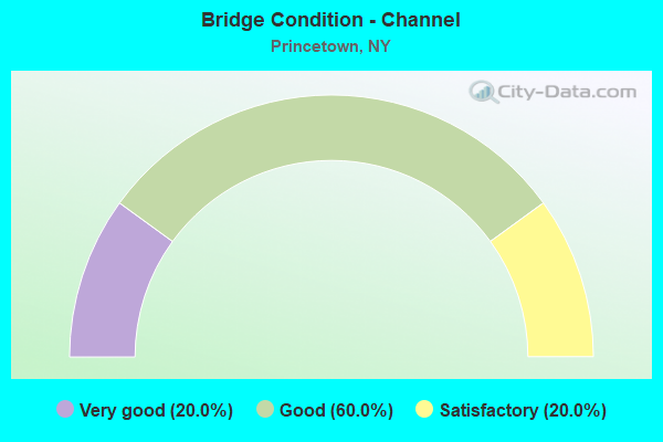
- Bridge Condition - Channel
- 20.0%Very good
- 60.0%Good
- 20.0%Satisfactory
Find on map >> Show street view
Structure Number: 100416, Location: 3.25 MI W JCT 7 & I890 (Lat: 42.777281, Lng: -74.074931), Route carried "on" structure: State highway 7, Year Built: 2011, Status: Open, Structure Length: 3.11m (10.20ft), Average Daily Traffic: 2,332 (year 2020), Truck Traffic: 9%, Average Future Daily Traffic: 2,432 (year 2040), Design Load: HL 93, Features Intersected: NORMANS KILL
Minimum Vertical Clearance: 30+ m (98+ ft), Kilometerpoint: 17.940, Lanes on structure: 2, Base Highway Network: Yes, Owner: State Highway Agency, Approaching Roadway Width: 10.4m (34.1ft), Skew: 2 degrees, Material/Design: Prestressed concrete, Design/Construction: Box Beam or Girders - Multiple, Number Of Spans In Main Unit: 1, Length of Maximum Span: 30.2m (99.1ft), Curb-To-Curb Width: 10.3m (33.8ft), Out-to-Out Width: 11.2m (36.7ft)
Condition: Deck: Good, Superstructure: Good, Substructure: Excellent, Channel: Good, Inventory Rating: 88.9 metric tons, Method Used To Determine Inventory Rating: Load Factor (LF), Structural Evaluation: Better than present minimum criteria, Deck Geometry: Meets minimum limits, Waterway Adequacy: Equal to present minimum criteria, Approach Roadway Alignment: Equal to present desirable criteria, Length Of Structure Improvement: 3.10m (10.17ft), Designated Inspection Frequency: Every 24 months, Inspection Date: October 2021, Bridge Improvement Cost: $1,183,000, Roadway Improvement Cost: $693,000, Total Project Cost: $1,875,000 ( Estimate for 2021), Deck Structure Type: Concrete Cast-file-Place, Wearing Surface/Protective System: Wearing Surface: Integral Concrete, Deck Protection: Epoxy Coated Reinforcing
Find on map >> Show street view
Structure Number: 1070641, Location: 0.3 MI SW JCT RTS I88 & 7 (Lat: 42.774725, Lng: -74.052561), Route carried "on" structure: Interstate 88, Year Built: 1980, Year Reconstructed: 2003, Status: Open, Structure Length: 4.88m (16.01ft), Average Daily Traffic: 7,111 (year 2004), Truck Traffic: 26%, Design Load: HS 20, Features Intersected: NORMANS KILL
Minimum Vertical Clearance: 30+ m (98+ ft), Kilometerpoint: 19.614, Lanes on structure: 3, Base Highway Network: Yes, Owner: State Highway Agency, Approaching Roadway Width: 14.0m (45.9ft), Material/Design: Steel, Design/Construction: Stringer/Multi-beam, Number Of Spans In Main Unit: 1, Length of Maximum Span: 47.2m (154.9ft), Curb-To-Curb Width: 14.0m (45.9ft), Out-to-Out Width: 14.6m (47.9ft)
Condition: Deck: Good, Superstructure: Good, Substructure: Fair, Channel: Good, Operating Rating: 97.1 metric tons, Method Used To Determine Operating Rating: Load Factor (LF), Inventory Rating: 58.1 metric tons, Method Used To Determine Inventory Rating: Load Factor (LF), Structural Evaluation: Somewhat better than minimum adequacy, Deck Geometry: Meets minimum limits, Waterway Adequacy: Equal to present minimum criteria, Approach Roadway Alignment: Equal to present desirable criteria, Length Of Structure Improvement: 4.87m (15.98ft), Designated Inspection Frequency: Every 24 months, Inspection Date: June 2020, Bridge Improvement Cost: $1,839,000, Roadway Improvement Cost: $1,077,000, Total Project Cost: $2,916,000 ( Estimate for 2021), Deck Structure Type: Concrete Cast-file-Place, Wearing Surface/Protective System: Wearing Surface: Bituminous, Membrane: Preformed Fabric, Deck Protection: Epoxy Coated Reinforcing
Find on map >> Show street view
Structure Number: 1070642, Location: 0.3 MI SW JCT RTS I88 & 7 (Lat: 42.774289, Lng: -74.052306), Route carried "on" structure: Interstate 88, Year Built: 1980, Year Reconstructed: 2003, Status: Open, Structure Length: 5.58m (18.31ft), Average Daily Traffic: 6,715 (year 2020), Truck Traffic: 17%, Average Future Daily Traffic: 7,997 (year 2040), Design Load: HS 20, Features Intersected: NORMANS KILL
Minimum Vertical Clearance: 30+ m (98+ ft), Kilometerpoint: 19.630, Lanes on structure: 2, Base Highway Network: Yes, Owner: State Highway Agency, Approaching Roadway Width: 12.8m (42.0ft), Material/Design: Steel, Design/Construction: Stringer/Multi-beam, Number Of Spans In Main Unit: 1, Length of Maximum Span: 54.2m (177.8ft), Curb-To-Curb Width: 12.8m (42.0ft), Out-to-Out Width: 13.4m (44.0ft)
Condition: Deck: Satisfactory, Superstructure: Good, Substructure: Good, Channel: Satisfactory, Inventory Rating: 62.6 metric tons, Method Used To Determine Inventory Rating: Load Factor (LF), Structural Evaluation: Better than present minimum criteria, Deck Geometry: Equal to present desirable criteria, Waterway Adequacy: Equal to present minimum criteria, Approach Roadway Alignment: Equal to present desirable criteria, Length Of Structure Improvement: 5.57m (18.27ft), Designated Inspection Frequency: Every 24 months, Inspection Date: June 2020, Bridge Improvement Cost: $1,912,000, Roadway Improvement Cost: $1,120,000, Total Project Cost: $3,032,000 ( Estimate for 2021), Deck Structure Type: Concrete Cast-file-Place, Wearing Surface/Protective System: Wearing Surface: Bituminous, Membrane: Preformed Fabric, Deck Protection: Epoxy Coated Reinforcing
Find on map >> Show street view
Structure Number: 1070661, Location: JCT OF SH 7 & I88 (Lat: 42.778131, Lng: -74.047608), Route carried "on" structure: Interstate 88, Year Built: 1980, Status: Open, Structure Length: 6.55m (21.49ft), Average Daily Traffic: 8,879 (year 2018), Truck Traffic: 13%, Average Future Daily Traffic: 10,515 (year 2039), Design Load: HS 20, Features Intersected: RTE 7
Minimum Vertical Clearance: 30+ m (98+ ft), Kilometerpoint: 20.209, Lanes on structure: 3, Lanes under structure: 2, Base Highway Network: Yes, Owner: State Highway Agency, Approaching Roadway Width: 13.7m (44.9ft), Material/Design: Steel, Design/Construction: Stringer/Multi-beam, Number Of Spans In Main Unit: 1, Length of Maximum Span: 64.9m (212.9ft), Curb-To-Curb Width: 13.7m (44.9ft), Out-to-Out Width: 14.6m (47.9ft)
Condition: Deck: Good, Superstructure: Fair, Substructure: Good, Inventory Rating: 64.4 metric tons, Method Used To Determine Inventory Rating: Load Factor (LF), Structural Evaluation: Somewhat better than minimum adequacy, Deck Geometry: Meets minimum limits, Underclear: Equal to present minimum criteria, Approach Roadway Alignment: Equal to present desirable criteria, Length Of Structure Improvement: 6.55m (21.49ft), Designated Inspection Frequency: Every 24 months, Inspection Date: June 2021, Bridge Improvement Cost: $2,409,000, Roadway Improvement Cost: $1,411,000, Total Project Cost: $3,819,000 ( Estimate for 2021), Deck Structure Type: Concrete Cast-file-Place, Wearing Surface/Protective System: Wearing Surface: Integral Concrete, Deck Protection: Epoxy Coated Reinforcing
Find on map >> Show street view
Structure Number: 1070662, Location: JCT OF SH 7 & I88 (Lat: 42.778122, Lng: -74.047072), Route carried "on" structure: Interstate 88, Year Built: 1980, Year Reconstructed: 2010, Status: Open, Structure Length: 6.55m (21.49ft), Average Daily Traffic: 6,715 (year 2020), Truck Traffic: 17%, Average Future Daily Traffic: 10,641 (year 2040), Design Load: HS 20, Features Intersected: RTE 7
Minimum Vertical Clearance: 30+ m (98+ ft), Kilometerpoint: 20.209, Lanes on structure: 2, Lanes under structure: 2, Base Highway Network: Yes, Owner: State Highway Agency, Approaching Roadway Width: 12.5m (41.0ft), Material/Design: Steel, Design/Construction: Stringer/Multi-beam, Number Of Spans In Main Unit: 1, Length of Maximum Span: 64.0m (210.0ft), Curb-To-Curb Width: 12.5m (41.0ft), Out-to-Out Width: 13.4m (44.0ft)
Condition: Deck: Good, Superstructure: Fair, Substructure: Good, Inventory Rating: 62.6 metric tons, Method Used To Determine Inventory Rating: Load Factor (LF), Structural Evaluation: Somewhat better than minimum adequacy, Deck Geometry: Better than present minimum criteria, Underclear: Somewhat better than minimum adequacy, Approach Roadway Alignment: Equal to present desirable criteria, Length Of Structure Improvement: 6.55m (21.49ft), Designated Inspection Frequency: Every 24 months, Inspection Date: June 2021, Bridge Improvement Cost: $2,239,000, Roadway Improvement Cost: $1,311,000, Total Project Cost: $3,550,000 ( Estimate for 2021), Deck Structure Type: Concrete Cast-file-Place, Wearing Surface/Protective System: Wearing Surface: Integral Concrete, Deck Protection: Epoxy Coated Reinforcing
Find on map >> Show street view
Structure Number: 1070671, Location: 2.2 MI E JCT I88 & US 20 (Lat: 42.772006, Lng: -74.080783), Route carried "on" structure: Interstate 88, Year Built: 1978, Year Reconstructed: 2011, Status: Open, Structure Length: 11.06m (36.29ft), Average Daily Traffic: 7,111 (year 2004), Truck Traffic: 26%, Design Load: HS 20, Features Intersected: UNNAMED STREAM, SUITS RA
Minimum Vertical Clearance: 30+ m (98+ ft), Kilometerpoint: 17.232, Lanes on structure: 3, Base Highway Network: Yes, Owner: State Highway Agency, Approaching Roadway Width: 14.0m (45.9ft), Material/Design: Steel continuous, Design/Construction: Stringer/Multi-beam, Number Of Spans In Main Unit: 2, Length of Maximum Span: 57.9m (190.0ft), Curb-To-Curb Width: 13.8m (45.3ft), Out-to-Out Width: 14.9m (48.9ft)
Condition: Deck: Good, Superstructure: Satisfactory, Substructure: Satisfactory, Channel: Good, Operating Rating: 93.6 metric tons, Method Used To Determine Operating Rating: Load and Resistance Factor Rating (LRFR) rating reported by rating factor(RF) method using HL-93 loadings, Inventory Rating: 72.3 metric tons, Method Used To Determine Inventory Rating: Load and Resistance Factor Rating (LRFR) rating reported by rating factor(RF) method using HL-93 loadings, Structural Evaluation: Equal to present minimum criteria, Deck Geometry: Meets minimum limits, Waterway Adequacy: Superior to present desirable criteria, Approach Roadway Alignment: Equal to present desirable criteria, Length Of Structure Improvement: 11.06m (36.29ft), Designated Inspection Frequency: Every 24 months, Inspection Date: May 2021, Bridge Improvement Cost: $3,591,000, Roadway Improvement Cost: $2,103,000, Total Project Cost: $5,694,000 ( Estimate for 2021), Deck Structure Type: Concrete Cast-file-Place, Wearing Surface/Protective System: Wearing Surface: Integral Concrete, Deck Protection: Epoxy Coated Reinforcing
Find on map >> Show street view
Structure Number: 1070672, Location: 2.2 MI E JCT RTS I88 & 20 (Lat: 42.771428, Lng: -74.081886), Route carried "on" structure: Interstate 88, Year Built: 1980, Status: Open, Structure Length: 12.53m (41.11ft), Average Daily Traffic: 6,715 (year 2020), Truck Traffic: 17%, Average Future Daily Traffic: 7,997 (year 2040), Design Load: HS 20, Features Intersected: UNNAMED STREAM, SUITS RA
Minimum Vertical Clearance: 30+ m (98+ ft), Kilometerpoint: 17.120, Lanes on structure: 2, Base Highway Network: Yes, Owner: State Highway Agency, Approaching Roadway Width: 12.8m (42.0ft), Material/Design: Steel continuous, Design/Construction: Stringer/Multi-beam, Number Of Spans In Main Unit: 2, Length of Maximum Span: 62.1m (203.7ft), Curb-To-Curb Width: 12.6m (41.3ft), Out-to-Out Width: 13.7m (44.9ft)
Condition: Deck: Fair, Superstructure: Poor, Substructure: Good, Channel: Very good, Operating Rating: 64.4 metric tons, Method Used To Determine Operating Rating: Load Factor (LF), Inventory Rating: 39.0 metric tons, Method Used To Determine Inventory Rating: Load Factor (LF), Structural Evaluation: Meets minimum limits, Deck Geometry: Better than present minimum criteria, Waterway Adequacy: Superior to present desirable criteria, Approach Roadway Alignment: Equal to present desirable criteria, Length Of Structure Improvement: 12.52m (41.08ft), Designated Inspection Frequency: Every 24 months, Inspection Date: June 2020, Bridge Improvement Cost: $3,678,000, Roadway Improvement Cost: $2,154,000, Total Project Cost: $5,832,000 ( Estimate for 2021), Deck Structure Type: Concrete Cast-file-Place, Wearing Surface/Protective System: Wearing Surface: Bituminous, Membrane: Other, Deck Protection: Epoxy Coated Reinforcing
Find on map >> Show street view
Structure Number: 1071311, Location: 1.4 MI SW JCT I88 & I90 (Lat: 42.780522, Lng: -74.039908), Route carried "on" structure: Interstate 88, Year Built: 1981, Year Reconstructed: 2010, Status: Open, Structure Length: 3.05m (10.01ft), Average Daily Traffic: 7,111 (year 2004), Truck Traffic: 26%, Design Load: HS 20, Features Intersected: PANGBURN ROAD
Minimum Vertical Clearance: 30+ m (98+ ft), Kilometerpoint: 20.885, Lanes on structure: 3, Lanes under structure: 2, Base Highway Network: Yes, Owner: State Highway Agency, Approaching Roadway Width: 13.7m (44.9ft), Skew: 1 degrees, Material/Design: Concrete, Design/Construction: Box Beam or Girders - Multiple, Number Of Spans In Main Unit: 1, Length of Maximum Span: 29.8m (97.8ft), Curb-To-Curb Width: 13.8m (45.3ft), Out-to-Out Width: 15.1m (49.5ft)
Condition: Deck: Good, Superstructure: Satisfactory, Substructure: Good, Operating Rating: 88.0 metric tons, Method Used To Determine Operating Rating: Load Factor (LF), Inventory Rating: 41.7 metric tons, Method Used To Determine Inventory Rating: Load Factor (LF), Structural Evaluation: Equal to present minimum criteria, Deck Geometry: High priority of corrective action, Underclear: High priority of corrective action, Approach Roadway Alignment: Equal to present desirable criteria, Length Of Structure Improvement: 3.04m (9.97ft), Designated Inspection Frequency: Every 24 months, Inspection Date: April 2021, Bridge Improvement Cost: $1,563,000, Roadway Improvement Cost: $915,000, Total Project Cost: $2,478,000 ( Estimate for 2021), Deck Structure Type: Concrete Cast-file-Place, Wearing Surface/Protective System: Wearing Surface: Integral Concrete, Deck Protection: Epoxy Coated Reinforcing
Find on map >> Show street view
Structure Number: 1071312, Location: 1.4 MI SW JCT I88 & I90 (Lat: 42.780350, Lng: -74.039767), Route carried "on" structure: Interstate 88, Year Built: 1981, Year Reconstructed: 2010, Status: Open, Structure Length: 3.05m (10.01ft), Average Daily Traffic: 6,715 (year 2020), Truck Traffic: 17%, Average Future Daily Traffic: 10,641 (year 2040), Design Load: HS 20, Features Intersected: PANGBURN ROAD
Minimum Vertical Clearance: 30+ m (98+ ft), Kilometerpoint: 20.885, Lanes on structure: 2, Lanes under structure: 2, Base Highway Network: Yes, Owner: State Highway Agency, Approaching Roadway Width: 12.5m (41.0ft), Skew: 1 degrees, Material/Design: Concrete, Design/Construction: Box Beam or Girders - Multiple, Number Of Spans In Main Unit: 1, Length of Maximum Span: 29.8m (97.8ft), Curb-To-Curb Width: 12.6m (41.3ft), Out-to-Out Width: 13.9m (45.6ft)
Condition: Deck: Good, Superstructure: Satisfactory, Substructure: Satisfactory, Operating Rating: 88.9 metric tons, Method Used To Determine Operating Rating: Load Factor (LF), Inventory Rating: 40.8 metric tons, Method Used To Determine Inventory Rating: Load Factor (LF), Structural Evaluation: Equal to present minimum criteria, Deck Geometry: Better than present minimum criteria, Underclear: High priority of corrective action, Approach Roadway Alignment: Equal to present desirable criteria, Length Of Structure Improvement: 3.04m (9.97ft), Designated Inspection Frequency: Every 24 months, Inspection Date: April 2021, Bridge Improvement Cost: $1,373,000, Roadway Improvement Cost: $804,000, Total Project Cost: $2,177,000 ( Estimate for 2021), Deck Structure Type: Concrete Cast-file-Place, Wearing Surface/Protective System: Wearing Surface: Integral Concrete, Deck Protection: Epoxy Coated Reinforcing
Find on map >> Show street view
Structure Number: 107394, Location: 3.1MI W.INT.RTES 337 & 7 (Lat: 42.778519, Lng: -74.068506), Route carried "on" structure: State highway 7, Year Built: 1987, Status: Open, Structure Length: 1.01m (3.31ft), Average Daily Traffic: 2,332 (year 2020), Truck Traffic: 9%, Average Future Daily Traffic: 2,885 (year 2040), Design Load: HS 20, Features Intersected: BONNY BROOK
Minimum Vertical Clearance: 30+ m (98+ ft), Kilometerpoint: 18.520, Lanes on structure: 2, Base Highway Network: Yes, Owner: State Highway Agency, Approaching Roadway Width: 9.8m (32.2ft), Material/Design: Prestressed concrete, Design/Construction: Box Beam or Girders - Multiple, Number Of Spans In Main Unit: 1, Length of Maximum Span: 9.7m (31.8ft), Curb-To-Curb Width: 9.8m (32.2ft), Out-to-Out Width: 10.5m (34.4ft)
Condition: Deck: Satisfactory, Superstructure: Good, Substructure: Satisfactory, Channel: Satisfactory, Operating Rating: 96.2 metric tons, Method Used To Determine Operating Rating: Load Factor (LF), Inventory Rating: 54.4 metric tons, Method Used To Determine Inventory Rating: Load Factor (LF), Structural Evaluation: Equal to present minimum criteria, Deck Geometry: Meets minimum limits, Waterway Adequacy: Somewhat better than minimum adequacy, Approach Roadway Alignment: Equal to present desirable criteria, Length Of Structure Improvement: 1.00m (3.28ft), Designated Inspection Frequency: Every 24 months, Inspection Date: July 2021, Bridge Improvement Cost: $678,000, Roadway Improvement Cost: $397,000, Total Project Cost: $1,076,000 ( Estimate for 2021), Deck Structure Type: Concrete Cast-file-Place, Wearing Surface/Protective System: Wearing Surface: Monolithic Concrete
Find on map >> Show street view
Structure Number: 330496, Location: 1.9 MI NE OF DUANESBURG (Lat: 42.783289, Lng: -74.104364), Route carried "on" structure: County highway , Year Built: 1991, Year Reconstructed: 2014, Status: Open, Structure Length: 1.13m (3.71ft), Average Daily Traffic: 123 (year 2020), Truck Traffic: 3%, Average Future Daily Traffic: 172 (year 2040), Design Load: HL 93, Features Intersected: NORMANS KILL TRIB, Facility Carried by Structure: SCOTCH RIDGE RD
Minimum Vertical Clearance: 30+ m (98+ ft), Kilometerpoint: 4.553, Lanes on structure: 2, Owner: County Highway Agency, Approaching Roadway Width: 8.5m (27.9ft), Material/Design: Wood or Timber, Design/Construction: Slab, Number Of Spans In Main Unit: 1, Length of Maximum Span: 10.6m (34.8ft), Curb-To-Curb Width: 7.9m (25.9ft), Out-to-Out Width: 8.5m (27.9ft)
Condition: Superstructure: Excellent, Substructure: Good, Channel: Good, Operating Rating: 53.5 metric tons, Method Used To Determine Operating Rating: Load Factor (LF), Inventory Rating: 36.3 metric tons, Method Used To Determine Inventory Rating: Load Factor (LF), Structural Evaluation: Better than present minimum criteria, Deck Geometry: Somewhat better than minimum adequacy, Waterway Adequacy: Somewhat better than minimum adequacy, Approach Roadway Alignment: Equal to present desirable criteria, Length Of Structure Improvement: 1.12m (3.67ft), Designated Inspection Frequency: Every 24 months, Inspection Date: August 2020, Bridge Improvement Cost: $387,000, Roadway Improvement Cost: $227,000, Total Project Cost: $614,000 ( Estimate for 2021), Deck Structure Type: Wood or Timber, Wearing Surface/Protective System: Wearing Surface: Bituminous, Membrane: Other
Find on map >> Show street view
Structure Number: 330497, Location: 1.8 MI SW OF PATTERSONVLE (Lat: 42.868911, Lng: -74.103408), Route carried "on" structure: County highway , Year Built: 1978, Status: Open, Structure Length: 2.26m (7.41ft), Average Daily Traffic: 69 (year 2018), Truck Traffic: 6%, Average Future Daily Traffic: 97 (year 2038), Design Load: H 15, Features Intersected: SANDSEA KILL, Facility Carried by Structure: MUSELBECK ROAD
Minimum Vertical Clearance: 30+ m (98+ ft), Kilometerpoint: 0.322, Lanes on structure: 2, Owner: County Highway Agency, Approaching Roadway Width: 7.9m (25.9ft), Skew: 2 degrees, Material/Design: Steel, Design/Construction: Stringer/Multi-beam, Number Of Spans In Main Unit: 1, Length of Maximum Span: 21.9m (71.9ft), Curb-To-Curb Width: 7.3m (24.0ft), Out-to-Out Width: 8.2m (26.9ft)
Condition: Deck: Fair, Superstructure: Fair, Substructure: Fair, Channel: Good, Operating Rating: 61.7 metric tons, Method Used To Determine Operating Rating: Load Factor (LF), Inventory Rating: 37.2 metric tons, Method Used To Determine Inventory Rating: Load Factor (LF), Structural Evaluation: Somewhat better than minimum adequacy, Deck Geometry: Equal to present minimum criteria, Waterway Adequacy: Somewhat better than minimum adequacy, Approach Roadway Alignment: Equal to present minimum criteria, Length Of Structure Improvement: 2.25m (7.38ft), Designated Inspection Frequency: Every 24 months, Inspection Date: May 2021, Bridge Improvement Cost: $546,000, Roadway Improvement Cost: $320,000, Total Project Cost: $866,000 ( Estimate for 2021), Deck Structure Type: Concrete Cast-file-Place, Wearing Surface/Protective System: Wearing Surface: Bituminous
Find on map >> Show street view
Structure Number: 330498, Location: 1.9MI SW PATTERSONVILLE (Lat: 42.868644, Lng: -74.103428), Route carried "on" structure: County highway , Year Built: 1935, Year Reconstructed: 2000, Status: Open, Structure Length: 1.22m (4.00ft), Average Daily Traffic: 63 (year 1993), Truck Traffic: 10%, Average Future Daily Traffic: 88 (year 2013), Features Intersected: SANDSEA KILL, Facility Carried by Structure: MUSELBECK RD (OLD)
Minimum Vertical Clearance: 30+ m (98+ ft), Kilometerpoint: 0.000, Lanes on structure: 1, Owner: County Highway Agency, Approaching Roadway Width: 4.3m (14.1ft), Material/Design: Wood or Timber, Design/Construction: Stringer/Multi-beam, Number Of Spans In Main Unit: 1, Length of Maximum Span: 11.3m (37.1ft), Curb-To-Curb Width: 4.3m (14.1ft), Out-to-Out Width: 4.9m (16.1ft)
Condition: Deck: Good, Superstructure: Very good, Substructure: Good, Channel: Good, Operating Rating: 60.8 metric tons, Method Used To Determine Operating Rating: Allowable Stress (AS), Inventory Rating: 44.5 metric tons, Method Used To Determine Inventory Rating: Allowable Stress (AS), Structural Evaluation: Better than present minimum criteria, Deck Geometry: Equal to present minimum criteria, Waterway Adequacy: Better than present minimum criteria, Approach Roadway Alignment: Somewhat better than minimum adequacy, Length Of Structure Improvement: 1.21m (3.97ft), Designated Inspection Frequency: Every 24 months, Inspection Date: May 2020, Bridge Improvement Cost: $204,000, Roadway Improvement Cost: $120,000, Total Project Cost: $324,000 ( Estimate for 2021), Deck Structure Type: Wood or Timber, Wearing Surface/Protective System: Wearing Surface: Wood or Timber
Find on map >> Show street view
Structure Number: 330499, Location: 3.7MI SW OF SCHENECTADY (Lat: 42.772922, Lng: -74.038778), Route carried "on" structure: County highway , Year Built: 2013, Status: Open, Structure Length: 3.20m (10.50ft), Average Daily Traffic: 1,791 (year 2020), Truck Traffic: 10%, Average Future Daily Traffic: 1,868 (year 2040), Design Load: HL 93, Features Intersected: NORMANS KILL, Facility Carried by Structure: PANGBURN ROAD
Minimum Vertical Clearance: 30+ m (98+ ft), Kilometerpoint: 2.671, Lanes on structure: 2, Owner: County Highway Agency, Approaching Roadway Width: 9.8m (32.2ft), Skew: 1 degrees, Material/Design: Steel, Design/Construction: Stringer/Multi-beam, Number Of Spans In Main Unit: 1, Length of Maximum Span: 30.5m (100.1ft), Curb-To-Curb Width: 9.8m (32.2ft), Out-to-Out Width: 10.8m (35.4ft)
Condition: Deck: Very good, Superstructure: Very good, Substructure: Excellent, Channel: Very good, Inventory Rating: 67.1 metric tons, Method Used To Determine Inventory Rating: Load Factor (LF), Structural Evaluation: Equal to present desirable criteria, Deck Geometry: Somewhat better than minimum adequacy, Waterway Adequacy: Equal to present minimum criteria, Approach Roadway Alignment: Equal to present desirable criteria, Length Of Structure Improvement: 3.20m (10.50ft), Designated Inspection Frequency: Every 24 months, Inspection Date: October 2021, Bridge Improvement Cost: $1,006,000, Roadway Improvement Cost: $589,000, Total Project Cost: $1,596,000 ( Estimate for 2021), Deck Structure Type: Concrete Cast-file-Place, Wearing Surface/Protective System: Wearing Surface: Integral Concrete, Deck Protection: Epoxy Coated Reinforcing
Find on map >> Show street view
Structure Number: 1070661, Location: JCT OF SH 7 & I88 (Lat: 42.778131, Lng: -74.047608), Route carried "under" structure: State highway 7, Year Built: 1980, Structure Length: 0. m, Average Daily Traffic: 11,064 (year 1999), Features Intersected: RTE 7, Facility Carried by Structure: RTE I88
Minimum Vertical Clearance: 4.47m (14.67ft), Kilometerpoint: 20.257, Lanes on structure: 3, Lanes under structure: 2, Material/Design: Steel, Design/Construction: Stringer/Multi-beam, Length of Maximum Span: 64.9m (212.9ft)
Find on map >> Show street view
Structure Number: 1070662, Location: JCT OF SH 7 & I88 (Lat: 42.778122, Lng: -74.047072), Route carried "under" structure: State highway 7, Year Built: 1980, Structure Length: 0. m, Average Daily Traffic: 11,064 (year 1999), Features Intersected: RTE 7, Facility Carried by Structure: RTE I88
Minimum Vertical Clearance: 4.50m (14.76ft), Kilometerpoint: 20.257, Lanes on structure: 2, Lanes under structure: 2, Material/Design: Steel, Design/Construction: Stringer/Multi-beam, Length of Maximum Span: 64.0m (210.0ft)
Find on map >> Show street view
Structure Number: 1071311, Location: 1.4 MI SW JCT I88 & I90 (Lat: 42.780522, Lng: -74.039908), Route carried "under" structure: Other road , Year Built: 1981, Structure Length: 0. m, Average Daily Traffic: 357 (year 2006), Truck Traffic: 6%, Features Intersected: PANGBURN ROAD, Facility Carried by Structure: RTE I88
Minimum Vertical Clearance: 4.80m (15.75ft), Kilometerpoint: 3.572, Lanes on structure: 3, Lanes under structure: 2, Material/Design: Concrete, Design/Construction: Box Beam or Girders - Multiple, Length of Maximum Span: 29.8m (97.8ft)
Find on map >> Show street view
Structure Number: 1071312, Location: 1.4 MI SW JCT I88 & I90 (Lat: 42.780350, Lng: -74.039767), Route carried "under" structure: Other road , Year Built: 1981, Structure Length: 0. m, Average Daily Traffic: 357 (year 2006), Truck Traffic: 6%, Features Intersected: PANGBURN ROAD, Facility Carried by Structure: RTE I88
Minimum Vertical Clearance: 4.47m (14.67ft), Kilometerpoint: 3.298, Lanes on structure: 2, Lanes under structure: 2, Material/Design: Concrete, Design/Construction: Box Beam or Girders - Multiple, Length of Maximum Span: 29.8m (97.8ft)
Find on map >> Show street view
Structure Number: 7305061, Location: JCT I88 & COUNTY ROAD 103 (Lat: 42.780672, Lng: -74.040028), Route carried "under" structure: County highway , Year Built: 1907, Structure Length: 0. m, Average Daily Traffic: 357 (year 2006), Truck Traffic: 6%, Features Intersected: PANGBURN RD-CR103, Facility Carried by Structure: DELAWARE & HUDSON
Minimum Vertical Clearance: 4.41m (14.47ft), Kilometerpoint: 3.588, Lanes under structure: 2, Material/Design: Steel, Design/Construction: Stringer/Multi-beam, Length of Maximum Span: 9.1m (29.9ft)