Bridge Statistics for Pulaski, New York (NY)
Condition, Traffic, Stress, Structural Evaluation, Project Costs
- National Bridge Inventory (NBI) Statistics
- 14Number of bridges
- 167ft / 51.2mTotal length
- $21,983,000Total costs
- 97,485Total average daily traffic
- 7,914Total average daily truck traffic
- National Bridge Inventory (NBI) Registered Bridges for Pulaski
- No street view available for this location
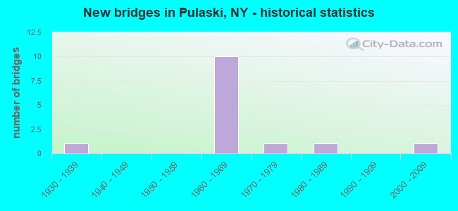
- New bridges - historical statistics
- 11930-1939
- 101960-1969
- 11970-1979
- 11980-1989
- 12000-2009
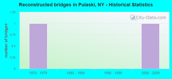
- Reconstructed bridges - Historical Statistics
- 11970-1979
- 01980-1989
- 01990-1999
- 12000-2009
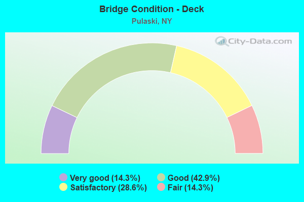
- Bridge Condition - Deck
- 14.3%Very good
- 42.9%Good
- 28.6%Satisfactory
- 14.3%Fair
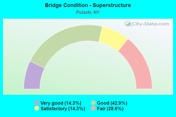
- Bridge Condition - Superstructure
- 14.3%Very good
- 42.9%Good
- 14.3%Satisfactory
- 28.6%Fair
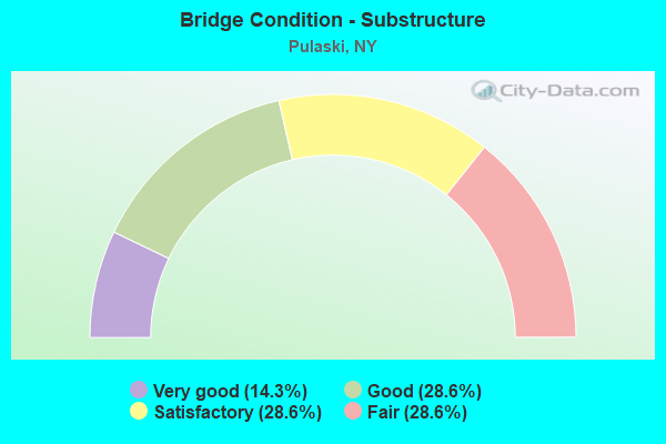
- Bridge Condition - Substructure
- 14.3%Very good
- 28.6%Good
- 28.6%Satisfactory
- 28.6%Fair
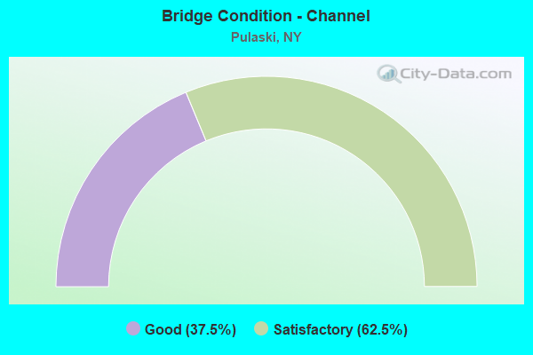
- Bridge Condition - Channel
- 37.5%Good
- 62.5%Satisfactory
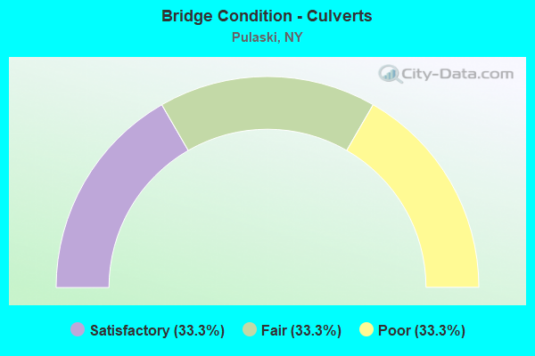
- Bridge Condition - Culverts
- 33.3%Satisfactory
- 33.3%Fair
- 33.3%Poor
Find on map >> Show street view
Structure Number: 10004, Location: 3.7MI SE JEFFERSON CL + 3 (Lat: 43.634153, Lng: -76.152844), Route carried "on" structure: State highway 3, Year Built: 2002, Status: Open, Structure Length: 2.56m (8.40ft), Average Daily Traffic: 1,279 (year 2018), Truck Traffic: 9%, Average Future Daily Traffic: 1,286 (year 2040), Design Load: HS 25 or greater, Features Intersected: LITTLE SANDY CRK
Minimum Vertical Clearance: 30+ m (98+ ft), Kilometerpoint: 64.280, Lanes on structure: 2, Base Highway Network: Yes, Owner: State Highway Agency, Approaching Roadway Width: 10.4m (34.1ft), Skew: 1 degrees, Material/Design: Prestressed concrete, Design/Construction: Box Beam or Girders - Multiple, Number Of Spans In Main Unit: 1, Length of Maximum Span: 24.6m (80.7ft), Curb-To-Curb Width: 10.3m (33.8ft), Out-to-Out Width: 11.3m (37.1ft)
Condition: Deck: Very good, Superstructure: Very good, Substructure: Very good, Channel: Satisfactory, Operating Rating: 99.8 metric tons, Method Used To Determine Operating Rating: Load Factor (LF), Inventory Rating: 57.2 metric tons, Method Used To Determine Inventory Rating: Load Factor (LF), Structural Evaluation: Equal to present desirable criteria, Deck Geometry: Somewhat better than minimum adequacy, Waterway Adequacy: Meets minimum limits, Approach Roadway Alignment: Equal to present desirable criteria, Length Of Structure Improvement: 2.56m (8.40ft), Designated Inspection Frequency: Every 24 months, Inspection Date: September 2020, Bridge Improvement Cost: $895,000, Roadway Improvement Cost: $524,000, Total Project Cost: $1,419,000 ( Estimate for 2021), Deck Structure Type: Concrete Cast-file-Place, Wearing Surface/Protective System: Wearing Surface: Monolithic Concrete, Deck Protection: Epoxy Coated Reinforcing
Find on map >> Show street view
Structure Number: 100858, Location: .3 MI N JCT US 11 & SH 13 (Lat: 43.565900, Lng: -76.127183), Route carried "on" structure: US 11, Year Built: 1935, Year Reconstructed: 1984, Status: Open, Structure Length: 2.74m (8.99ft), Average Daily Traffic: 8,323 (year 2020), Truck Traffic: 3%, Average Future Daily Traffic: 8,374 (year 2040), Design Load: H 20, Features Intersected: SALMON RIVER
Minimum Vertical Clearance: 30+ m (98+ ft), Kilometerpoint: 36.701, Lanes on structure: 4, Base Highway Network: Yes, Owner: State Highway Agency, Approaching Roadway Width: 12.8m (42.0ft), Material/Design: Steel, Design/Construction: Girder and Floorbeam System, Number Of Spans In Main Unit: 1, Length of Maximum Span: 26.2m (86.0ft), Curb or Sidewalk Widths: Left: 1.5m (4.9ft), Right: 1.5m (4.9ft), Curb-To-Curb Width: 12.8m (42.0ft), Out-to-Out Width: 16.6m (54.5ft)
Condition: Deck: Satisfactory, Superstructure: Good, Substructure: Satisfactory, Channel: Good, Operating Rating: 80.7 metric tons, Method Used To Determine Operating Rating: Load Factor (LF), Inventory Rating: 48.1 metric tons, Method Used To Determine Inventory Rating: Load Factor (LF), Structural Evaluation: Equal to present minimum criteria, Deck Geometry: High priority of replacement, Waterway Adequacy: Superior to present desirable criteria, Approach Roadway Alignment: Equal to present desirable criteria, Length Of Structure Improvement: 2.74m (8.99ft), Designated Inspection Frequency: Every 24 months, Critical Feature Inspection Frequency: Every 24 months, Underwater Inspection Frequency: Every 60 months, Inspection Date: July 2020, Critical Feature Inspection Date: July 2020, Underwater Inspection Date: June 2019, Bridge Improvement Cost: $1,612,000, Roadway Improvement Cost: $944,000, Total Project Cost: $2,555,000 ( Estimate for 2021), Deck Structure Type: Concrete Cast-file-Place, Wearing Surface/Protective System: Wearing Surface: Integral Concrete
Find on map >> Show street view
Structure Number: 101068, Location: JCT OF RTS 13 + I-81 (Lat: 43.555422, Lng: -76.113767), Route carried "on" structure: State highway 13, Year Built: 1961, Status: Open, Structure Length: 9.45m (31.00ft), Average Daily Traffic: 8,384 (year 2019), Truck Traffic: 8%, Average Future Daily Traffic: 8,435 (year 2040), Design Load: HS 20, Features Intersected: 81I 81I34041223 SB, RTE
Minimum Vertical Clearance: 30+ m (98+ ft), Kilometerpoint: 28.254, Lanes on structure: 2, Lanes under structure: 4, Base Highway Network: Yes, Owner: State Highway Agency, Approaching Roadway Width: 9.1m (29.9ft), Skew: 3 degrees, Material/Design: Steel, Design/Construction: Stringer/Multi-beam, Number Of Spans In Main Unit: 5, Length of Maximum Span: 21.0m (68.9ft), Curb or Sidewalk Widths: Left: 0.5m (1.6ft), Right: 0.5m (1.6ft), Curb-To-Curb Width: 9.1m (29.9ft), Out-to-Out Width: 10.7m (35.1ft)
Condition: Deck: Fair, Superstructure: Good, Substructure: Satisfactory, Operating Rating: 42.6 metric tons, Method Used To Determine Operating Rating: Allowable Stress (AS), Inventory Rating: 22.7 metric tons, Method Used To Determine Inventory Rating: Allowable Stress (AS), Structural Evaluation: Somewhat better than minimum adequacy, Deck Geometry: Meets minimum limits, Underclear: High priority of corrective action, Approach Roadway Alignment: Equal to present desirable criteria, Length Of Structure Improvement: 9.44m (30.97ft), Designated Inspection Frequency: Every 24 months, Inspection Date: July 2021, Bridge Improvement Cost: $2,036,000, Roadway Improvement Cost: $1,192,000, Total Project Cost: $3,228,000 ( Estimate for 2021), Deck Structure Type: Concrete Cast-file-Place, Wearing Surface/Protective System: Wearing Surface: Bituminous, Membrane: Preformed Fabric
Find on map >> Show street view
Structure Number: 1031901, Location: JCT RTE I-81 SB+SALMON R (Lat: 43.559628, Lng: -76.114122), Route carried "on" structure: Interstate 81, Year Built: 1961, Status: Open, Structure Length: 6.64m (21.78ft), Average Daily Traffic: 7,949 (year 2004), Truck Traffic: 28%, Design Load: HS 20, Features Intersected: SALMON RIVER
Minimum Vertical Clearance: 30+ m (98+ ft), Kilometerpoint: 36.428, Lanes on structure: 2, Base Highway Network: Yes, Owner: State Highway Agency, Approaching Roadway Width: 9.1m (29.9ft), Skew: 2 degrees, Material/Design: Steel, Design/Construction: Stringer/Multi-beam, Number Of Spans In Main Unit: 3, Length of Maximum Span: 21.3m (69.9ft), Curb or Sidewalk Widths: Left: 0.5m (1.6ft), Right: 0.5m (1.6ft), Curb-To-Curb Width: 9.1m (29.9ft), Out-to-Out Width: 10.7m (35.1ft)
Condition: Deck: Good, Superstructure: Fair, Substructure: Fair, Channel: Good, Operating Rating: 57.2 metric tons, Method Used To Determine Operating Rating: Load Factor (LF), Inventory Rating: 33.6 metric tons, Method Used To Determine Inventory Rating: Load Factor (LF), Structural Evaluation: Somewhat better than minimum adequacy, Deck Geometry: Meets minimum limits, Waterway Adequacy: Superior to present desirable criteria, Approach Roadway Alignment: Equal to present desirable criteria, Length Of Structure Improvement: 6.64m (21.78ft), Designated Inspection Frequency: Every 24 months, Inspection Date: August 2021, Bridge Improvement Cost: $1,528,000, Roadway Improvement Cost: $895,000, Total Project Cost: $2,423,000 ( Estimate for 2021), Deck Structure Type: Concrete Cast-file-Place, Wearing Surface/Protective System: Wearing Surface: Epoxy Overlay
Find on map >> Show street view
Structure Number: 1031902, Location: JCT RTE I-81 NB+SALMON R (Lat: 43.559475, Lng: -76.113653), Route carried "on" structure: Interstate 81, Year Built: 1961, Status: Open, Structure Length: 6.64m (21.78ft), Average Daily Traffic: 5,938 (year 2019), Truck Traffic: 18%, Average Future Daily Traffic: 6,656 (year 2040), Design Load: HS 20, Features Intersected: SALMON RIVER
Minimum Vertical Clearance: 30+ m (98+ ft), Kilometerpoint: 36.428, Lanes on structure: 2, Base Highway Network: Yes, Owner: State Highway Agency, Approaching Roadway Width: 9.1m (29.9ft), Skew: 2 degrees, Material/Design: Steel, Design/Construction: Stringer/Multi-beam, Number Of Spans In Main Unit: 3, Length of Maximum Span: 21.3m (69.9ft), Curb or Sidewalk Widths: Left: 0.5m (1.6ft), Right: 0.5m (1.6ft), Curb-To-Curb Width: 9.1m (29.9ft), Out-to-Out Width: 10.7m (35.1ft)
Condition: Deck: Good, Superstructure: Fair, Substructure: Fair, Channel: Satisfactory, Operating Rating: 50.8 metric tons, Method Used To Determine Operating Rating: Load Factor (LF), Inventory Rating: 29.9 metric tons, Method Used To Determine Inventory Rating: Load Factor (LF), Structural Evaluation: Somewhat better than minimum adequacy, Deck Geometry: Meets minimum limits, Waterway Adequacy: Meets minimum limits, Approach Roadway Alignment: Equal to present desirable criteria, Length Of Structure Improvement: 6.64m (21.78ft), Designated Inspection Frequency: Every 24 months, Inspection Date: August 2021, Bridge Improvement Cost: $1,541,000, Roadway Improvement Cost: $902,000, Total Project Cost: $2,444,000 ( Estimate for 2021), Deck Structure Type: Concrete Cast-file-Place, Wearing Surface/Protective System: Wearing Surface: Epoxy Overlay
Find on map >> Show street view
Structure Number: 103191, Location: .8 MILE N JCT I81 & SH 13 (Lat: 43.567158, Lng: -76.113897), Route carried "on" structure: County highway , Year Built: 1961, Year Reconstructed: 2006, Status: Open, Structure Length: 8.05m (26.41ft), Average Daily Traffic: 2,900 (year 2020), Truck Traffic: 6%, Average Future Daily Traffic: 2,917 (year 2040), Design Load: HS 20, Features Intersected: 81 81 34041231 NB, RTE, Facility Carried by Structure: RICHLAND ROAD
Minimum Vertical Clearance: 30+ m (98+ ft), Kilometerpoint: 1.110, Lanes on structure: 2, Lanes under structure: 6, Owner: State Highway Agency, Approaching Roadway Width: 9.1m (29.9ft), Material/Design: Steel, Design/Construction: Stringer/Multi-beam, Number Of Spans In Main Unit: 5, Length of Maximum Span: 17.6m (57.7ft), Curb or Sidewalk Widths: Left: 0.5m (1.6ft), Right: 0.5m (1.6ft), Curb-To-Curb Width: 9.1m (29.9ft), Out-to-Out Width: 10.7m (35.1ft)
Condition: Deck: Satisfactory, Superstructure: Satisfactory, Substructure: Good, Operating Rating: 46.3 metric tons, Method Used To Determine Operating Rating: Load Factor (LF), Inventory Rating: 27.2 metric tons, Method Used To Determine Inventory Rating: Load Factor (LF), Structural Evaluation: Equal to present minimum criteria, Deck Geometry: Meets minimum limits, Underclear: High priority of corrective action, Approach Roadway Alignment: Equal to present desirable criteria, Length Of Structure Improvement: 8.04m (26.38ft), Designated Inspection Frequency: Every 24 months, Inspection Date: July 2021, Bridge Improvement Cost: $1,728,000, Roadway Improvement Cost: $1,012,000, Total Project Cost: $2,740,000 ( Estimate for 2021), Deck Structure Type: Concrete Cast-file-Place, Wearing Surface/Protective System: Wearing Surface: Bituminous, Membrane: Preformed Fabric
Find on map >> Show street view
Structure Number: 1068051, Location: 0.7 MI N JCT I-81 SB +13 (Lat: 43.565817, Lng: -76.113939), Route carried "on" structure: Interstate 81, Year Built: 1961, Status: Open, Structure Length: 0.82m (2.69ft), Average Daily Traffic: 7,949 (year 2004), Truck Traffic: 28%, Design Load: HS 20, Features Intersected: SPRING BROOK, RESERVOIR
Minimum Vertical Clearance: 30+ m (98+ ft), Kilometerpoint: 37.184, Lanes on structure: 2, Base Highway Network: Yes, Owner: State Highway Agency, Approaching Roadway Width: 12.2m (40.0ft), Material/Design: Steel, Design/Construction: Culvert, Number Of Spans In Main Unit: 3, Length of Maximum Span: 2.1m (6.9ft)
Condition: Channel: Good, Culverts: Fair, Operating Rating: 73.9 metric tons, Method Used To Determine Operating Rating: Field evaluation and documented engineering judgment, Inventory Rating: 29.4 metric tons, Method Used To Determine Inventory Rating: Field evaluation and documented engineering judgment, Structural Evaluation: Somewhat better than minimum adequacy, Waterway Adequacy: Superior to present desirable criteria, Approach Roadway Alignment: Equal to present desirable criteria, Length Of Structure Improvement: 0.82m (2.69ft), Designated Inspection Frequency: Every 24 months, Inspection Date: October 2021, Bridge Improvement Cost: $232,000, Roadway Improvement Cost: $136,000, Total Project Cost: $369,000 ( Estimate for 2021)
Find on map >> Show street view
Structure Number: 1068052, Location: 0.7 MI N JCT I-81 NB +13 (Lat: 43.565803, Lng: -76.113475), Route carried "on" structure: Interstate 81, Year Built: 1961, Status: Open, Structure Length: 0.82m (2.69ft), Average Daily Traffic: 5,938 (year 2019), Truck Traffic: 18%, Average Future Daily Traffic: 6,656 (year 2040), Design Load: HS 20, Features Intersected: SPRING BROOK, RESERVOIR
Minimum Vertical Clearance: 30+ m (98+ ft), Kilometerpoint: 37.184, Lanes on structure: 2, Base Highway Network: Yes, Owner: State Highway Agency, Approaching Roadway Width: 21.9m (71.9ft), Skew: 30 degrees, Material/Design: Steel, Design/Construction: Culvert, Number Of Spans In Main Unit: 3, Length of Maximum Span: 2.1m (6.9ft)
Condition: Channel: Satisfactory, Culverts: Poor, Operating Rating: 73.9 metric tons, Method Used To Determine Operating Rating: Field evaluation and documented engineering judgment, Inventory Rating: 29.4 metric tons, Method Used To Determine Inventory Rating: Field evaluation and documented engineering judgment, Structural Evaluation: Meets minimum limits, Waterway Adequacy: Superior to present desirable criteria, Approach Roadway Alignment: Equal to present desirable criteria, Length Of Structure Improvement: 0.82m (2.69ft), Designated Inspection Frequency: Every 24 months, Inspection Date: October 2021, Bridge Improvement Cost: $418,000, Roadway Improvement Cost: $245,000, Total Project Cost: $664,000 ( Estimate for 2021)
Find on map >> Show street view
Structure Number: 320926, Location: VILLAGE OF PULASKI (Lat: 43.563422, Lng: -76.130308), Route carried "on" structure: County highway , Year Built: 1978, Status: Open, Structure Length: 12.47m (40.91ft), Average Daily Traffic: 2,301 (year 2018), Truck Traffic: 3%, Average Future Daily Traffic: 3,221 (year 2038), Design Load: HS 20, Features Intersected: SALMON RIVER, Facility Carried by Structure: SO JEFFERSON ST
Minimum Vertical Clearance: 30+ m (98+ ft), Kilometerpoint: 0.161, Lanes on structure: 2, Owner: County Highway Agency, Approaching Roadway Width: 10.4m (34.1ft), Material/Design: Steel continuous, Design/Construction: Stringer/Multi-beam, Number Of Spans In Main Unit: 3, Length of Maximum Span: 48.1m (157.8ft), Curb or Sidewalk Widths: Left: 1.5m (4.9ft), Right: 1.5m (4.9ft), Curb-To-Curb Width: 10.4m (34.1ft), Out-to-Out Width: 14.0m (45.9ft)
Condition: Deck: Good, Superstructure: Good, Substructure: Good, Channel: Satisfactory, Operating Rating: 90.7 metric tons, Method Used To Determine Operating Rating: Load Factor (LF), Inventory Rating: 54.4 metric tons, Method Used To Determine Inventory Rating: Load Factor (LF), Structural Evaluation: Better than present minimum criteria, Deck Geometry: Somewhat better than minimum adequacy, Waterway Adequacy: Somewhat better than minimum adequacy, Approach Roadway Alignment: Equal to present desirable criteria, Length Of Structure Improvement: 12.46m (40.88ft), Designated Inspection Frequency: Every 24 months, Inspection Date: August 2020, Bridge Improvement Cost: $3,625,000, Roadway Improvement Cost: $2,123,000, Total Project Cost: $5,748,000 ( Estimate for 2021), Deck Structure Type: Concrete Cast-file-Place, Wearing Surface/Protective System: Wearing Surface: Integral Concrete
Find on map >> Show street view
Structure Number: 331372, Location: 2.6 MI N OF PULASKI (Lat: 43.603189, Lng: -76.130878), Route carried "on" structure: County highway , Year Built: 1988, Status: Open, Structure Length: 0.98m (3.22ft), Average Daily Traffic: 1,032 (year 2017), Truck Traffic: 5%, Average Future Daily Traffic: 1,445 (year 2037), Features Intersected: DEER CREEK, Facility Carried by Structure: NORTH STREET RD
Minimum Vertical Clearance: 30+ m (98+ ft), Kilometerpoint: 3.894, Lanes on structure: 2, Owner: County Highway Agency, Approaching Roadway Width: 11.0m (36.1ft), Material/Design: Steel, Design/Construction: Culvert, Number Of Spans In Main Unit: 2, Length of Maximum Span: 4.2m (13.8ft)
Condition: Channel: Satisfactory, Culverts: Satisfactory, Operating Rating: 74.4 metric tons, Method Used To Determine Operating Rating: Field evaluation and documented engineering judgment, Inventory Rating: 19.6 metric tons, Method Used To Determine Inventory Rating: Field evaluation and documented engineering judgment, Structural Evaluation: Somewhat better than minimum adequacy, Waterway Adequacy: Meets minimum limits, Approach Roadway Alignment: Equal to present desirable criteria, Length Of Structure Improvement: 0.97m (3.18ft), Designated Inspection Frequency: Every 24 months, Inspection Date: May 2020, Bridge Improvement Cost: $248,000, Roadway Improvement Cost: $145,000, Total Project Cost: $393,000 ( Estimate for 2021)
Find on map >> Show street view
Structure Number: 101068, Location: JCT OF RTS 13 + I-81 (Lat: 43.555422, Lng: -76.113767), Route carried "under" structure: Interstate 81, Year Built: 1961, Structure Length: 0. m, Average Daily Traffic: 15,164 (year 1999), Features Intersected: 81I 81I34041223 SB, RTE, Facility Carried by Structure: RTE 13
Minimum Vertical Clearance: 5.05m (16.57ft), Kilometerpoint: 36.186, Lanes on structure: 2, Lanes under structure: 2, Material/Design: Steel, Design/Construction: Stringer/Multi-beam, Length of Maximum Span: 21.0m (68.9ft)
Find on map >> Show street view
Structure Number: 103191, Location: .8 MILE N JCT I81 & SH 13 (Lat: 43.567158, Lng: -76.113897), Route carried "under" structure: Interstate 81, Year Built: 1961, Structure Length: 0. m, Average Daily Traffic: 15,164 (year 1999), Features Intersected: 81 81 34041231 NB, RTE, Facility Carried by Structure: RICHLAND ROAD
Minimum Vertical Clearance: 5.03m (16.50ft), Kilometerpoint: 37.474, Lanes on structure: 2, Lanes under structure: 4, Material/Design: Steel, Design/Construction: Stringer/Multi-beam, Length of Maximum Span: 17.6m (57.7ft)
Find on map >> Show street view
Structure Number: 703189, Location: SE CORNER OF PULASKI (Lat: 43.558783, Lng: -76.114142), Route carried "under" structure: Interstate , Year Built: 1961, Structure Length: 0. m, Features Intersected: 81I 81I34041226 NB, RTE, Facility Carried by Structure: CSX TRANSPRTATION
Minimum Vertical Clearance: 4.90m (16.08ft), Kilometerpoint: 36.540, Lanes under structure: 2, Material/Design: Steel, Design/Construction: Stringer/Multi-beam, Length of Maximum Span: 14.0m (45.9ft)
Find on map >> Show street view
Structure Number: 703189, Location: SE CORNER OF PULASKI (Lat: 43.558783, Lng: -76.114142), Route carried "under" structure: Interstate 81, Year Built: 1961, Structure Length: 0. m, Average Daily Traffic: 15,164 (year 1999), Features Intersected: 81I 81I34041226 NB, RTE, Facility Carried by Structure: CSX TRANSPRTATION
Minimum Vertical Clearance: 4.95m (16.24ft), Kilometerpoint: 36.540, Lanes under structure: 2, Material/Design: Steel, Design/Construction: Stringer/Multi-beam, Length of Maximum Span: 14.0m (45.9ft)